
by Richard L. Thornton, Architect and City Planner
Chattahoochee is an Itza Maya word that was absorbed into the Creek languages.
The vast majority of residents in the Southern Highlands strongly support public access to, recognition and preservation of our ancient heritage. They seem to understand something that state officials have forgotten. Rural Appalachia is in critical need of economic development and international heritage tourism would be a mighty fine vitamin shot! It is a complex story that mixes indigenous peoples from many parts of the Americas, Bronze Age colonists from Scandinavia and Ireland, French Huguenot refugees, Sephardic Jewish refugees, Iberian gold miners, the nation’s first major gold rush and hardy 19th century settlers from the British Isles. What do you do when the US Forest Service practices Machiavellian activities, which are totally against the public’s economic welfare and an aging clique of archaeologists place their first loyalty to wannabe gambling casino developers?
A few days ago, on the seventh anniversary of the filming of the premier of the History Channel’s “America Unearthed” I went on a sentimental tour of the filming locations in North Georgia during a Sunday afternoon at the peak of the Summer Tourist Season. Helen, the Nacoochee Valley and Dahlonega were packed with tourists. Restaurants in downtown Clarkesville (Habersham County) had people waiting outside to get a table. I then went over Testnatee Gap and drove by the tiny gravel parking lot of the Track Rock Archaeological Zone. I discovered tourists from Florida, California and Atlanta standing around dumbfounded . . . trying to figure out where the stone ruins were. They were there because they had recently watched a re-run of the premier of America Unearthed on the Travel Channel. Needless to say, they were absolutely shocked to see one of the “stars” of the program step out of his Ford Explorer to give them directions. LOL
I drove on to nearby Blairsville, the county seat, to grab some lunch. I was appalled. It was like a ghost town. Many stores where I had shopped, while living in the county in 2010 and 2011 during the Great Recession, were now empty shells, displaying aged “For Rent” signs. Several restaurants were open, but either had no customers or perhaps one or two cars. There should have been at least some patrons from the nearby churches that had just let out . . . but even they had fled the downtown. How could that be? That prime time TV program on December 21, 2012 about a spectacular archaeological zone in their county is now the most watched one hour documentary ever broadcast by the History Channel .

Union County, Georgia . . . home of the Track Rock Archaeological Zone . . . is looking into an economic abyss. It was more prosperous during the height of the Great Recession than now, while most of northern Georgia is booming. Its population is aging rapidly and declining. Empty commercial buildings and houses dot the landscape. It has lost almost all its conventional industry, which was only partially replaced by a state prison and the locally-owned United Community Bank Corporate Headquarters. Once a prime destination for tourism, Union is now a county that tourists hurry through to go elsewhere. Its neighbors, Towns and Fannin Counties are now also experiencing population decline. Depressed real estate prices have attracted fringe political groups, who love to get national publicity for their wacko ideas . . . and politically influential drug dealers, who don’t want tourists (aka strangers) coming around at all.
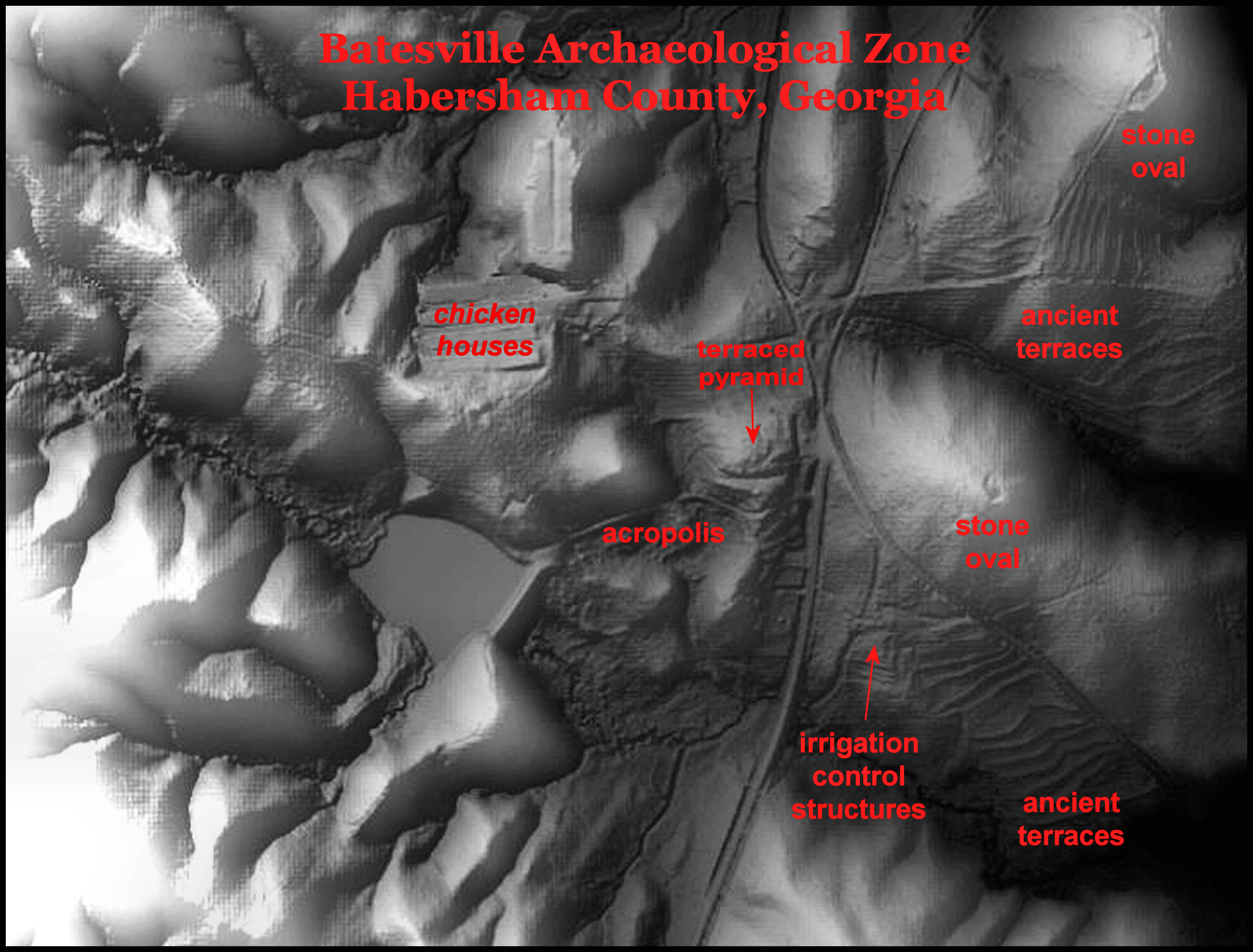
Like the county around it, the half square mile Track Rock Archaeological Zone has deteriorated during the past seven years under the hostile ownership of the US Forest Service. Although the ruins have been open to the public since the 1920s, the USFS in 2013 cut down trees to block access trails, removed directional signs on nearby highways that were erected in the 1970s and still refuses to give tourists directions to the stone ruins. A small, poorly maintained parking lot can hold seven cars. A great gash has been cut into the national forest by bulldozers and left as raw dirt, with no erosion control devices. An adjacent 8 acre residential compound . . . ideal location for a museum and parking lot . . . has been on the market for two years. You would have thought that someone in the county government or perhaps, United Community Bank, would have grabbed the real estate in order to develop international heritage tourism. Nope . . . the idea didn’t even occur to the realtor, who got the listing.
How could this be? An internationally-broadcast TV program on a massive archaeological site in their county was followed by several less noticed programs on other channels, plus thousands newspaper articles around the world . . . even in Mongolia, Tahiti and the Vatican! The local leadership has done absolutely nothing to capitalize on this golden egg laid by a media goose.
Two entities can get most of the blame for sabotaging efforts to develop heritage tourism in Union County . . . the US Forest Service Office in Gainesville, GA and a clique of aging Georgia archaeologists, who for the past 30 years have been “consultants” for enigmatic corporations, which want to develop “Cherokee casinos” in the Georgia Mountains . . . even though there is no Cherokee Reservation in Georgia. People living in an economically depressed county are less likely to oppose a gambling casino.
It is a well documented fact, but was hushed up during the controversy over the “Mayas in Georgia Thang” that only a couple of years before this TV program, the Gainesville Office of the Chattahoochee National Forest was busted for racketeering and violation of the Hatch Act. When the Bush Administration ordered the privatization of many USFS activities, the Gainesville office laid off dozens of career employees and replaced them with contractors associated with organized crime. Gainesville has been a major center of the Dixie Mafia for decades.
What really got the USFS management in trouble, though, was that they began requiring local businesses and logging companies to make contributions to certain right-wing Republican candidates in order to do business with the USFS. Their illegal actions were exposed by outraged Republicans, who didn’t have access to those funds. Apparently, the Democrats knew nothing about the scheme until it was in the newspapers.

This article, however, will focus on the culpability of the archaeologists involved with US Forest Service’s “Maya Myth-Busting in the Mountains” campaign. That’s right, at a time when this agency was facing major budget cuts, many thousands of your tax dollars were funding a ludicrous public relations program that was trying for nine months in advance to discredit a prime time History Channel program, which would feature major tourist attractions from several parts of Georgia. Well, for that matter, most Georgia Creeks carry Maya DNA and about a third of our words are borrowed from the Itza Maya language. Three of the largest rivers in Georgia have Maya names!
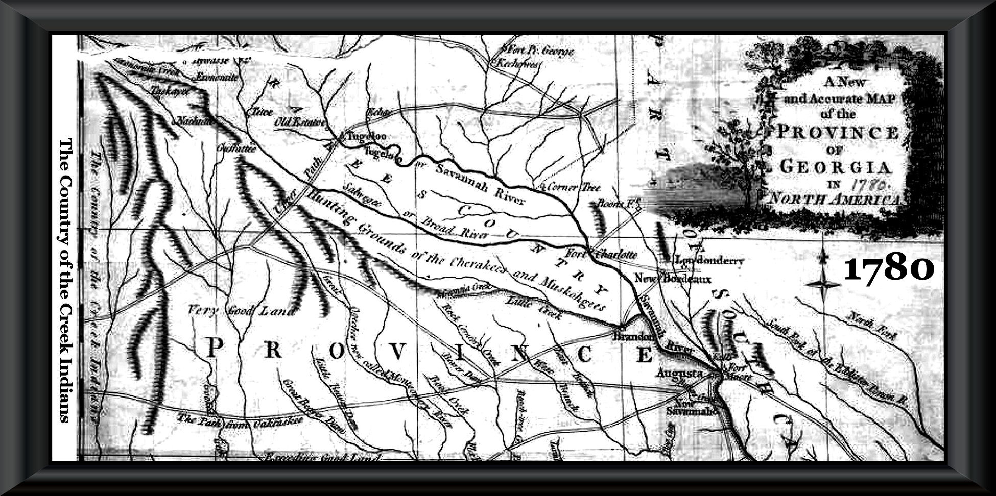
As clearly illustrated by the official British Army map above . . . until 1785, Track Rock Gap and Brasstown Bald Mountain were in the territory of the Creek Confederacy. How did contemporary archaeologists in Dixie get their strange ideas about the stone ruins at Track Rock Gap being created by Cherokees, when the Cherokees did not even appear on maps of North Carolina until 1711? About half of the terrace complexes are in areas where the Cherokees never lived.
The archaeologists most ridiculous beliefs are that “the petroglyphs in North Georgia are graffiti, carved by bored Cherokee hunters” . . . and the literally thousands of agricultural terraces in North and West Georgia “were platforms, built by the Cherokees to host sacred dances” . . . . and the thousands of stone cairns in the Southern Highlands “were the burial places of great Cherokee chiefs.” Most of the archaeologists’ professional papers merely cite their contemporary buddies as the sources of these non-facts. That is about as reliable as you hiring me to be the Architect of a 100,000 seat sports stadium. At least most architects have the sense to not discuss in public subjects for which they have no qualifications.
Famous archaeologists from the past
After going around in circles with 21st and late 20th century academicians quoting each other as references, I finally came down to names of three persons from the late 19th century and early 20th century, who were originally named in the 1970s as the authorities for the ludicrous ideas, described in the introductory paragraph. They were ethnologist-archaeologist James Mooney, archaeologist Cyrus Thomas and archaeologist George Heye. All three had something in common. Although worshiped as saints by contemporary archaeologists, none of these gentlemen had any academic qualifications, whatsoever, for their chosen profession. They were quite intelligent men, but lacking a broad education and immersion into all Native cultures, they repeatedly made mistakes . . . particularly in the Southeast, where we had a dense, multi-ethnic population prior to European Invasion.

Cyrus Thomas (1825-1910) was a Tennessee politician, who stayed loyal to the Union, and therefore was rewarded during Reconstruction by progressively more important political appointments by Republican administrations. Before the Civil War, he attended a village school in NE Tennessee then Jonesborough Academy in Jonesboro, TN, but did not graduate. Nevertheless, he was later able to pass the Bar Exam and practice law then later became a Lutheran minister for awhile. He then became a self-taught entomologist (insect expert) and accompanied the Hayden Expedition in 1869 to the Rocky Mountains as its assistant entomologist. Upon returning back East from the 1871 Hayden Expedition was appointed as a full professor at Southern Illinois University and then Chief Entomologist for the State of Indiana. At this time, 1882, he was appointed Chief Archaeologist to the United States Bureau of American Ethnology. How his self-taught knowledge on insects transcended into being the nation’s most influential archaeologist is a matter of conjecture. Throughout the 1880s, Thomas headed the Bureau of Ethnology’s Mound Excavation Program, whose objective was to prove that the mounds in the Eastern United States were built by Native Americans. In his professional writings, Thomas took this objective a step farther by trying to prove his belief that the Adena, Hopewell and Southern Highlands Mounds were built by the Cherokees. Thus, he is always cited as a reference when contemporary Cherokee spokespersons claim that the Cherokees built most of the mounds in the Southeast and Midwest.

James Mooney (1861-1921) is the name most commonly referenced by contemporary archaeologists, when they interpreted Native American sites in the Southern Highlands. He was a first generation Irish-American from Indiana, who highest educational level was the 12th grade of public high school. Mooney was fascinated by American Indian cultures and read everything he could on the subject after graduation from high school. After graduating from high school in 1878, Mooney taught public school for one year, and then joined the staff of the Richmond Palladium. Charles Stewart Parnell, who toured the United States in late 1879 on behalf of the newly formed National Land League of Ireland, stirred Mooney’s passion and idealism. Mooney helped organize a local Richmond chapter of the Land League and served as its first secretary. When the English Parliament passed land reform measures shortly thereafter, much of the original enthusiasm for the league dissipated. Mooney, late in 1884 tried to gain employment at the Smithsonian Institution’s Bureau of Ethnology (later renamed the Bureau of American Ethnology), which had been founded in 1879 to organize anthropological knowledge in the United States and provide the national government with solutions to the vexing “Indian problem.” His novel approach of studying Native Cultures was to actually live among them and learn their language and cultural history. He remained employed by the Smithsonian Institute until 1921. Mooney is best known for his book, Myths of the Cherokees, which was published by the US Government Printing Office in 1900. A significant portion of the book, however, is NOT composed of myths of the Cherokees, but rather Mooney’s version of the history of the Southern Highlands . . . from the perspective of late 19th century Cherokees in western North Carolina and Tennessee historian-politician, John Haywood.
George Heye (1874-1957) was a wealthy mining industry baron in New York City, who developed his interest in archaeology to a semi-professional obsession. He was the founder of the Heye Museum, which became the American Museum of Natural History. It was either Heye or professional archaeologists, employed by Heye, who excavated the famous Nacoochee Mound near Helen, GA and the Peachtree Mound near Murphy, NC.
In 1873, pioneer Georgia archaeologists, Charles C. Jones, Jr, had described the artifacts at the Nacoochee Mound as being very similar to those found at Creeks towns near Macon and Columbus. In 1915, none of Heye’s team had prior experience in either Georgia or the Southern Appalachians. Heye stated in his report that James Mooney had determined that all the pottery associated with mounds in the Southern Appalachians were created by the Cherokees. This statement is replicated in a legion of 20th and 21st century archaeology books. We will tell you what Mooney actually said later in the article Heye also made this blanket statement in regard to the pottery at the Nacoochee and Peachtree Mounds: “This ware is of the typical Southern Appalachian form and style, in no particular respect different from that of other pottery made by the Cherokee in early times.” The fact is that the pottery at the Nacoochee and Peachtree Mounds is entirely different that 18th century Cherokee pottery and even different from the 18th century Shawnee pottery in the Tuckasegee River Basin farther east in North Carolina and the Little Tennessee River Basin, farther north.
The reference citation in Heye’s Report on the Nacoochee Mound was for: W. H. Holmes, Aboriginal Pottery of Eastern United States, Fifteenth Annual Report of the Bureau of American Ethnology, Washington, 1903. Unlike what appears to be virtually every member of the archaeology profession today, I downloaded a copy of Holmes’ report and actually read it. Holmes stated just the opposite of what Heye said, when discussing Southern Appalachian pottery. He actually wrote this in regard to the “Mound Builders” pottery in western North Carolina, Tennessee and Northern Georgia: “Of these groups the Muskogeans probably have the best claim to authorship of this ware.” p. 151. George Heye lied.

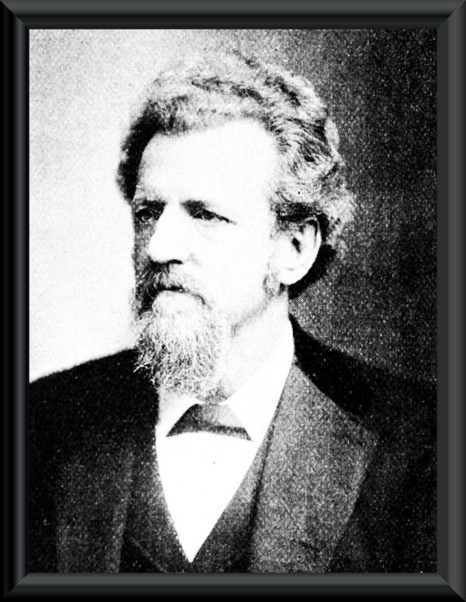
William Henry Holmes (1846-1933) during the late 1800s and first half of the 20th century was considered the nation’s leading expert on Native American ceramics. Unlike Cyrus Thomas and James Mooney, he did have some college education in geology, anthropology, biology and art history . . . but did not graduate. He developed his knowledge of art history and ceramics after college to the point by the late 1860s that he was considered an expert on the subject. Along with Cyrus Thomas, he was on the 1871 Hayden Expedition, but went on several more archaeological expeditions throughout the 1870s. There is no doubt that by 1901, when he wrote the report on American Indian pottery for the Smithsonian Institute, he was the most professionally qualified archaeologist in the United States. Look at his bio!
After the Hayden Survey was absorbed into the U.S. Geological Survey in 1879, Holmes went to Munich, Germany, to further his art studies under Frank Duveneck and to take lessons in “museum making” from Adolphe B. Meyer of Dresden’s Anthropology Museum. On Holmes’s return to the U.S., he was hired by the Geological Survey and assigned to Clarence Dutton as a geologist and illustrator. Holmes illustrated the atlas for Dutton’s Tertiary History of the Grand Canyon District (1882); his triptych panorama of the Grand Canyon from Point Sublime is a masterpiece of American scientific illustration. He was also a noted mountain climber, and a peak in Yellowstone National Park — Mount Holmes — was named in his honor. In 1875, Holmes began studying the remains of the Ancestral Pueblo culture in the San Juan River region of Utah. His models of ancient Indian ruins were a sensation at the Centennial International Exhibition in Philadelphia. Holmes became particularly interested in prehistoric pottery and shell art, producing the published works of “Art in Shell of the American Indians (1883)” and “Pottery of the Ancient Pueblos (1886)”. He expanded these studies to include textiles, and he became well known as an expert in both ancient and existing arts produced by Native Americans of the Southwest. In 1889 he discovered and reported Indian petroglyphs in central West Virginia.
When asked to examine the pottery of the Adena and Hopewell Cultures in the Ohio Valley and compare it to samples of pottery in the Southeast, Holmes did not tell Cyrus Thomas what he wanted to hear. Holmes saw no connection between 18th century Cherokee pottery and the Pre-Colonial Period ceramics of Ohio and the Southeast. The Cherokee pottery might have been made from the same clay as that produced by earlier peoples, but they were from entirely different cultural traditions. Apparently, in the 1970s North Carolina archaeology professors, working on the “Cherokee History Project” ignored Holmes’ report and instead quoted the misquotes made by George Heye as an excuse to label “Pisgah Period” and “Early Qualla Period” ceramics as being made by the Cherokees.
Concealment of the real Cherokee history
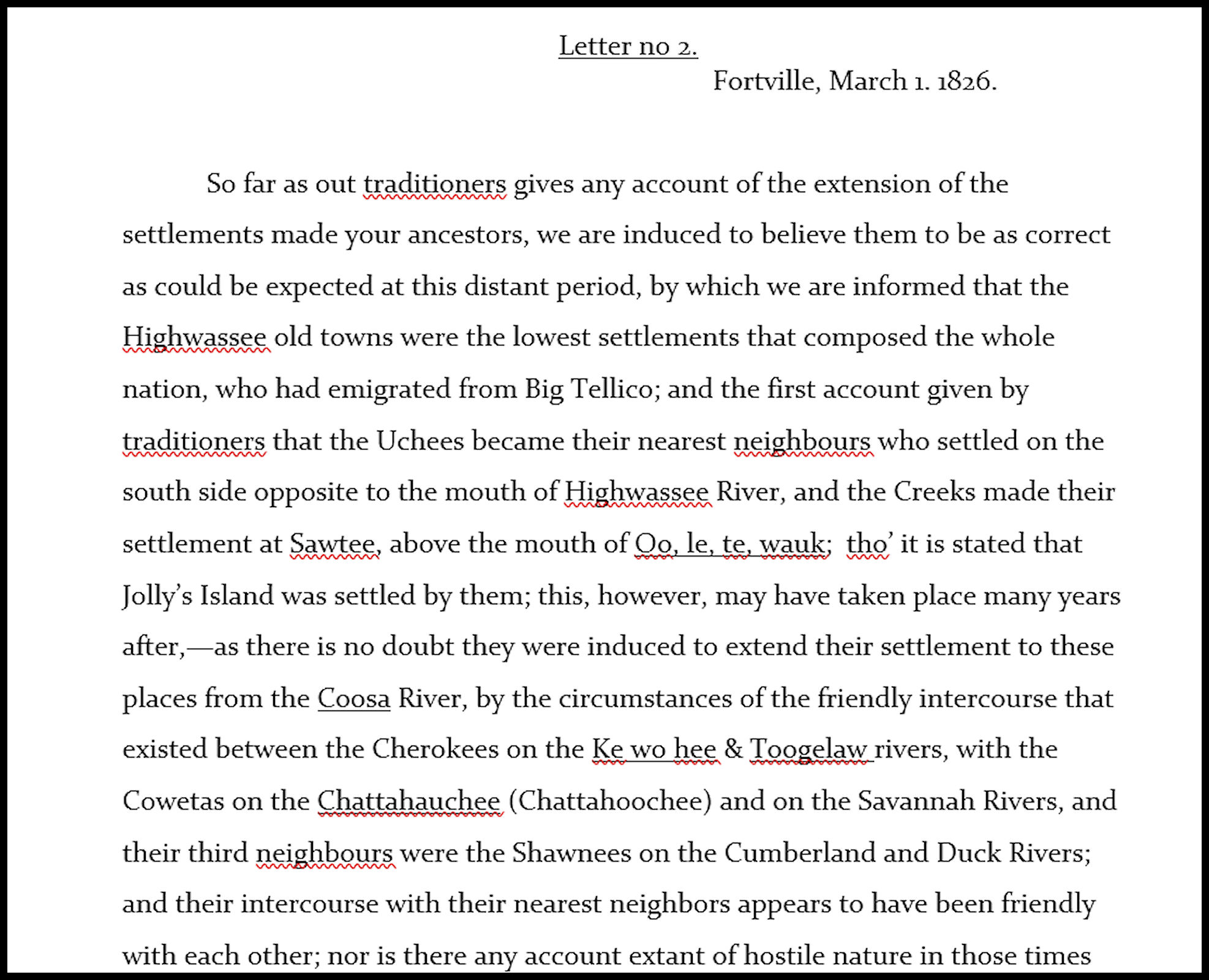
In 1826 and early 1827, Cherokee Principal Chief Charles Hicks wrote eight long letters to the newly elected President of the National Council, John Ross, concerning the history of the Cherokee People. It is a very different history than told to the public today. The Cherokees once had detailed migration legends, but by 1826 had forgotten them. These letters really only cover the recent history of the Cherokees after they arrived in the South, because even by then, they had forgotten where they came from. For many decades, these letters were in the possession of the Knoxville, TN Public Library System. Shortly after the “New Cherokee History” was released to the public in the 1970s by the State of North Carolina, the Knoxville Library System quietly SOLD these priceless letters to the Newberry Research Library in Chicago, IL. The obvious purpose was to get them away from the eyes of Southeastern researchers and news reporters.
I hope to complete the transcription and publish the eight letters in early 2020. I have obtained high resolution photographs of the original letters and was in the process of transcribing them, when the opportunity arose in the spring of 2018 for me to purchase a very nice house in the Nacoochee Valley for the price of a used trailer.
There is very little in these letters, which is compatible with the current version of Cherokee history being promulgated by tribal bureaucrats and North Carolina academicians. Hicks stated that the Cherokees arrived on the western edge of the Southern Appalachians about the same time that Charleston was founded. He went on to say that the “mound builders” in the North Carolina Mountains had once been very numerous, but had been severely weakened by a series of plagues. He said that the Cherokees killed or drove off the mound builders, burned their temples and constructed Cherokee town houses (council houses) on top of the mounds. It is curious that Hicks distinguished between the Creeks and Uchee, who lived in Tennessee and the tip of North Carolina in the 1700s and the “mound builders.”

There are several statements in the Hicks letters, which are also lies. He said that the Cherokees occupied all the land in Tennessee south to the Hiwassee River for a century before the Creek-Cherokee War broke out in 1716. Both French and English maps from 1711 and 1715 show a French fort and two Upper Creek villages on the island at the intersection of the Little Tennessee and Tennessee Rivers. [See above.] The maps show the Little Tennessee and Upper Tennessee Rivers to be occupied by Kusate (Upper Creek), Koasati towns, Tokahre-Uchee and Shawnee towns all the way to the French Broad River. The Tennessee was then named the Cusatee River. Nevertheless, Hicks’ version of Cherokee history was far more accurate than what is being taught public school students today.
Blatant misrepresentations of James Mooney’s writings
You would think that James Mooney was a full-blooded Cherokee elder from the frequency of his name appearing in “Cherokee History” books. One gets the impression that it is carried around like the Holy Bible . . . but like the Holy Bible, is rarely read in its entirety. What his disciples are carrying their arms is 1995 compilation by Dover Publications of all of Mooney’s Bureau of Ethnology reports . . . “slightly modified and rearranged.” The “slightly” refers to a bogus map of the Cherokee Nation, which shows the Cherokees always occupying all of Tennessee and Kentucky, western Virginia, West Virginia, all of northern Alabama and Georgia, western North Carolina and a huge chunk of South Carolina, where the Cherokees never lived. All of the Chickasaw’s territory in 1784, is labeled Cherokee.
Mooney correctly stated that the Chickasaws won their long war with the Cherokees in 1768. He stated that the Cherokees would not attempt to enter Chickasaw territory in Northeast Alabama, until it was given to the Cherokees in the 1785 Treaty of Hopewell Plantation. On the other hand, Mooney matter-of-factly mentioned, without giving a source, the fictional battle of Taliwa in North Georgia during 1755, where the Cherokees supposedly conquered all of North Georgia down to Atlanta (page 38). This fairy tale was contrived by a distant cousin of Nancy Ward, four years after her death. However, Mooney was passed on this tale by some Cherokee elders in Qualla, NC. Actually, the Cherokees were catastrophically defeated by the Coweta Creeks in the autumn of 1754 and signed a surrender treaty that December. John Mitchell’s 1755 Map of North Carolina labels a broad swath of Northeast Georgia and far Western North Carolina as “Deserted Cherokee Settlements” . . . hardly the case, if they had just conquered all of North Georgia. LOL
In the initial chapter of his book, Mooney speculated on the early history of the Cherokees. He relied heavily on a book, published by Tennessee jurist and politician, John Haywood, which is titled, The Natural and Aboriginal History of Tennessee (1823). From pages 16 thought 20, he provided linguistic evidence that the Cherokees were a northern tribe, speaking a Algonquian dialect. He equated them to the Rickohockens in southwestern Virginia. Several books, published by “Cherokee” or “Wannabe” authors, cite Mooney as saying that the Cherokees have always lived in the Southern Highlands. He never said this.
On pages 20-22, Mooney provided substantial evidence that the Cherokees did not build the mounds and stone structures in the Southern Highlands. He mentioned Cyrus Thomas’s belief that the Cherokees built the Adena and Hopewell Culture Mounds. However, he countered Thomas’s belief with the statements by Cherokee elders, who said that even when they were migrating southward through Ohio and West Virginia, the mounds looked like they do today and that they had no idea, who built the mounds in either the North or the Southeast. Virtually all books, written by contemporary archaeologists and academicians from North Carolina . . . and some from Georgia and Tennessee . . . quote this very same book as saying that Mooney had determined that the mounds in North Carolina and North Georgia were built by the Cherokees. It is a lie.
In that same section, and in the next chapter, Mooney stated that very few American Indian geographical place names in the mountains of North Carolina, Georgia and Tennessee seem to have any meaning in any of the four known Cherokee dialects. Well . . . yes . . . both rivers on the North Carolina Cherokee Reservation are Creek words. There is a Cherokee name for the Oconaluftee River, but it is only used today by a few Cherokees in remote communities. For that reason, Mooney speculated that all of the Southern Highlands were originally occupied by the “Creeks” . . . as if they were one ethnic group. Actually, the region was jointly occupied by Uchee, Itsate Creeks (Itza Mayas) from southern Mexico, Panoans from Peru, Chiska from Peru, Southern Arawaks from Peru, Kusate-Creeks, Tuskegee Creeks, Tokahsi-Creeks from western Veracruz, Mexico, Tamatli from Veracruz, Apalache-Creeks from Peru, Soque (Sautee) from Southern Mexico, Muskogee-speaking Creeks, Chickasaw, Kansa from North Georgia and South Carolina, Shawnee and lord knows who else. These statements are NEVER included in Cherokee histories, because the Cherokees now claim to have lived in Western North Carolina for 12,000 years. Mooney even mentioned that the original name for New Echota was Gansa-gi, but it never dawned on him that Gansa-gi is the Cherokee name for the Kansa People.
On pages 25 through 29, Mooney discussed the exploration of the Southern Highlands by the Spanish. He rolled off the Creek or Itza Maya names of towns visited by De Soto or Pardo, yet he inexplicably called them Cherokee towns. They were the same words, which in an earlier section of the chapter, he listed as not being Cherokee towns. Mooney made no effort to learn the Creek languages or heaven forbid, the languages of eastern and southern Mexico, where many Creek tribes originated. A legion of “Cherokee history” books liberally quote Mooney as stating that Chiliqui or Chalaqui were attempts by the Spanish to pronounce the Cherokee’s name. No they are not. Chiliqui is the Totonac, Itza Maya and Itsate Creek word for “barbarian.” Chalaqui is he Muskogee-Creek word for barbarian. Chorakee is the Muskogee-Creek word for a splinter group and probably only originally applied to the eight Creek-speaking villages at the head of the Savannah River, which later were labeled as “Lower Cherokees”. All of the surviving Lower Cherokee village names and words are Itsate-Creek words!
Mooney discussed the century of Spanish mining and colonization activities in the Southern Highlands as a matter of fact on page 29. He is seldom quoted on this opinion because it conflicts with what archaeologists learned in school. On the other hand, he was completely ignorant of the multiple and detailed French descriptions of the interior of the Southeastern United States prior to the arrival of the Cherokees in the region during the 1690s. In 1658, Charles de Rochefort devoted ten chapters of his famous book on the region that is now Georgia, eastern Alabama and western North Carolina. His book is by far the most detailed descriptions that we have of the “Creek” Indians prior to the book by James Adair, published in 1775, when their culture had changed radically. De Rochefort made no mention of either Cherokees or the Rickohockens. The ignorance of Southeastern academicians toward French eyewitness descriptions continues to this day.

Plagiarism at Track Rock Gap
James Mooney was contemptuous of the petroglyphs and stone ruins at Track Rock Gap near Blairsville, GA. He did sketch a few of the glyphs and included them in his book. He briefly described the site on pages 418 and 419. Mooney speculated that most of the rock carvings were too old to have been made by the Cherokees, but also dismissed them as being meaningless marks by resting hunters. Mooney was also dismissive of Charles C. Jones, Jr.’s description of massive stone ruins nearby, claiming that Jones was never there. The opposite is the truth. Mooney never explored the half square mile archaeological zone which rises 800 feet up the mountainside. Mooney did include an excerpt of a description of the petroglyphs made by someone named Stephenson in 1834.

I followed the evidence provided and eventually discovered the entire report by Dr. William H. Stephenson . . . newly appointed director of the US Mint at Dahlonega. Stephenson had no clue of what he was looking at, but at least he was a good writer and provided some detailed descriptions. Here is what shocked me, though. There is little difference in Stephenson’s interpretation of the petroglyphs and stone ruins versus the two reports made to the US Forrest Service by “professional archaeologists” in 2000 and 2001. Sections of paragraphs and entire sentences were “cut and pasted.” What was presented as the sophisticated analysis by learned archaeologists was merely the guesswork of a tourist from Virginia in 1834 . . . with no credit given the tourist. Both documents use the term, “Graffiti by bored Cherokee hunters.”
I have been able to obtain a copy of the full report by Dr. Mathew H. Stephenson. Much of it is interesting because it describes what the Georgia Mountains looked like during the five decades of the Cherokee Nation. They were mostly in a natural state with a few inhabitants, who did not have Cherokee names. In an upcoming edition of “The America’s Revealed” you will be able to compare what Stephenson wrote in 1834 to what professional archaeologists submitted to the United States Forestry Service in the first years of the 21st century . . . and called the product of their highly skilled, professional investigation. Remember, your tax money paid for this malarkey.
As for the “graffiti carved by bored Cherokee hunters” . . . there are four Itza Maya glyphs carved over much older the glyphs at Track Rock Gap. Most of the older glyphs can be found on a rock outcrop in Nyköping, Sweden. The Nyköping Petroglyphs have been dated to 2000 BC. We are finding many more Nyköping style petroglyphs in Northeast Georgia. They represent the Bronze Age writing system of Scandinavia. What I cannot explain however, is why some of the most important Maya glyphs were being carved on a rock face in Sweden, 2,400 years earlier. The truth is out there, but it is awfully durn hard to find it these days in US Forest Service-funded archaeological studies.

“George Heye (1974-1957) was a wealthy mining industry baron…” I think his birth-date should read 1874? instead of 1974? Thank-you for the interesting articles!
LikeLike
You are absolutely right . . . but its the fault of you folks in Macon sending your hot, humid weather up to the mountains. My brain has molded!
LikeLike
Richard, I am so very sorry about your other site. You are doing such valuable and interesting work. As I was starting to research my family, I knew something was not quite right in what I was reading. I hope you won’t let the true history that you uncovered perish.
LikeLike