by Richard L. Thornton, Architect & City Planner
It’s a little-known fact, ether in Ireland or the United States. During the Great Potato Famine, the only ports open to Irish immigrants were Savannah and Charleston. A huge percentage of Southern whites and Native Americans have at least some Irish or Scottish ancestry. They considered and still consider the Irish their kin – regardless of what particular branch of Christianity they adhered to.
The mega-wealthy Guiness family of Ireland only donated ≠£160 to feed the starving. On the other side of the Atlantic, many cities in Dixie, even the Choctaw Indian Nation, sent entire shiploads of food to feed the Irish. Meanwhile, the British stationed and fed 100,000 soldiers in Ireland to guard the shipments of vast quantities of grain, livestock and beer back to England. In the years 1846 and 1847, Ireland exported 430,000 tons of grain to England! Queen Victoria’s economic advisor, Nassau Senior, expressed his fear that the Irish famine “would not kill more than one million people, and that would scarcely be enough to do any good”.
A primary reason for the lack of awareness that many Southerners (both Caucasian and Native American) are part Irish and Scottish, is the provincial nature of our history courses in the US. I probably was exposed to maybe three or four paragraphs of Irish history in high school. Ireland was not even mentioned in my 2 ½ years of architectural history at Georgia Tech or four classes of Urban History in grad school at Georgia State. History textbooks of newer vintage will spend several paragraphs, maybe even a chapter of the Ulster Scots . . . aka Scotch-Irish, but say very little about the rest of Ireland and Scotland.
Ireland has its own provinciality too. The Irish tend to associate being victims of blatant discrimination and being at least nominally Roman Catholic with being REAL Irish. Irish immigrants were crowded into Northeast ghettos and discriminated against because of their version of Christianity. The more numerous Irish, Scottish and Welsh immigrants to the Southeastern United States were quickly assimilated and spread across the landscape, all the way to California. I find that many Irish in Ireland and New England tense up when I mention the fact that most Roman Catholic Irish immigrants to the Southeast sooner or later became Protestants . . . because the Protestants in the Southeast accepted them as equals from day one. English Anglicans typically treated the Irish dirt better than they did their Irish tenant farmers.
In recent years, however, I have profound evidence that at the end of the Ice Age the same Asiatic people lived in Ireland, the Maritime Provinces and New England. Then several thousand years later, Pre-Gaelic peoples, originally from Scandinavia, immigrated in several waves to Eastern North America via Ireland.
Thinking that I am off my rocker? Consider this. The suffix “gi” (sometimes written as ki or kee, but pronounced the same) means “people or tribe” in Irish/Scottish Gaelic, Algonquian, Delaware, Shawnee, Cherokee and Muskogee-Creek . . . plus several tribes in Mesoamerica and South America. My own branch of the Creeks, the Itsate, use an Itza Maya suffix for “People or Tribe.”
En vacker Svensk sommardag
Early in the morning after graduation from Georgia Tech, I boarded a Delta jet headed to New York, which would connect with a British Airways Boeing 747 to London, which would connect with a SAS flight to Copenhagen, from which a bus would take me to Tuborghamn, from which would depart the ship, Dana Scarlett, to Landskrona, Sweden. There, I would start the next morning at a job, I didn’t apply for at the Landskrona Stadsarkitektkontoret (Town Architect’s Office).
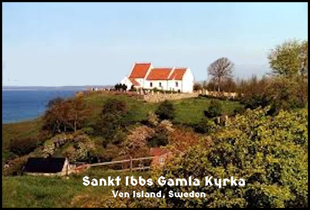
On the third day at work, my boss, Stadsarkitekt Gunner Lydh, accompanied me by boat to Ven Island, where I was to design a pedestrian village, near a 14th century farm. We then walked over to a 12th century church, Sankt Ibbs Gamla Kyrka . . . which was built on top of a Bronze Age and Iron Age worship site.
petroglyphs in northern Georgia.
After visiting the church, we then shuffled down the side of the grassy cliff to the edge of the Oresund Chanel. He wanted to show me helleristningar (petroglyphs) that had been carved in some large boulders, perhaps 3,000 to 4,000 years ago. I was stunned to see that they were all Creek and Uchee Indian sacred symbols. At that time, I was not even aware that the Creek Homeland had petroglyphs, but certainly these symbols were endemic in our art. I told that to Gunner and he laughed.
In the many years since that first, beautiful Wednesday on Ven, seeing those petroglyphs has been a nagging question in the back of my head. Why would the same religious symbols exist in southern Sweden and the Southeastern United States? It would be a long, long time before I even knew that the Picts originated in southern Sweden and the ancestors of the English originated in Denmark.
A profound lack of curiosity
I initially tried to find out more information on the petroglyphic sites in the Southern Highlands from articles and papers, authored by archaeologists. They were useless. While petroglyphic sites in Europe are usually popular tourist attractions and receive serious study by anthropologists, who happen to know something about their ancestors, many of these sites in the Southern Highlands are completely unknown to the general public and often even local residents and academicians.
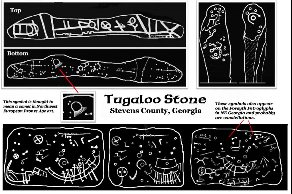
Google “Petroglyphs in Georgia” and you will get a handful of national-international websites, which list a couple of the better-known petroglyphs in Georgia, commented on by people, who have never seen them in person. There are two more websites by Georgia archaeologists, who don’t have clue as to what the petroglyphs mean or who made them. They use Latin and Greek based words to describe these symbols to make you think they do. None of these websites seem to be aware that ALL of these symbols can be found at Bronze Age sites in Europe. For 225 years, academicians looked at the Tugaloo Rock Petroglyphs . . . upside down!
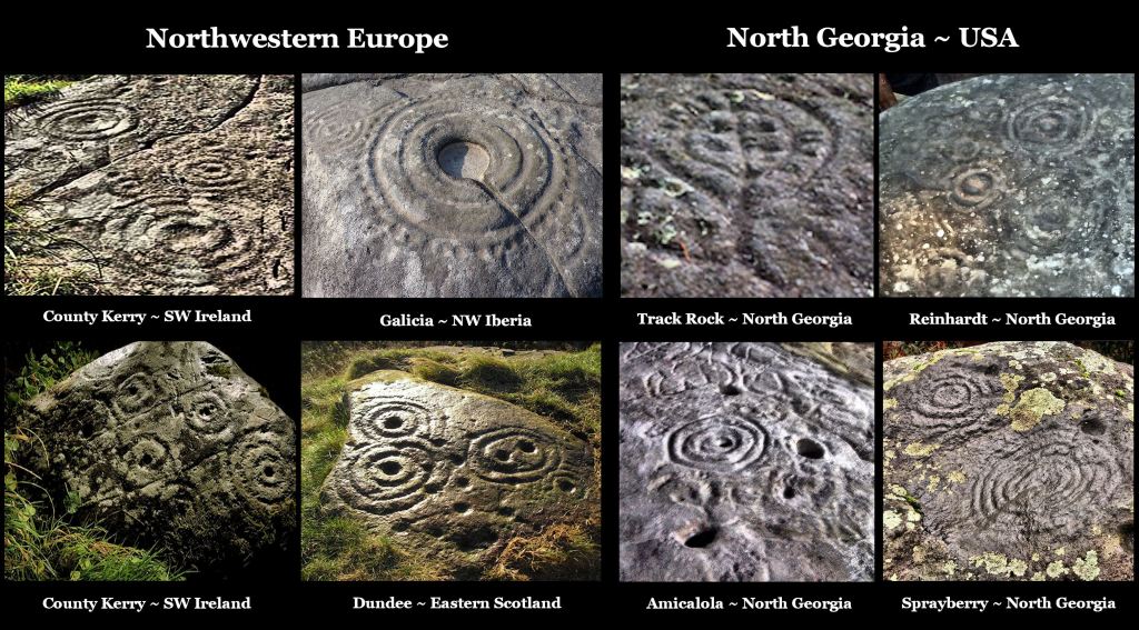
The Petroglyphs of the Georgia Gold Belt
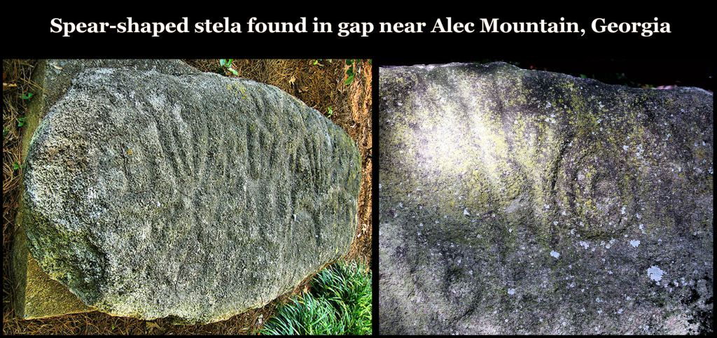
Almost evenly distributed across the hills and mountains of northern Georgia are large boulders, on whose exposed surfaces were carved geometric forms and abstract symbols. Generally known as petroglyphs, the rock carvings of this region are different than most, because the majority of the incised images are not humans, animals or plants. The boulders were originally located on relatively high points of the terrain and near major Native American trade paths.
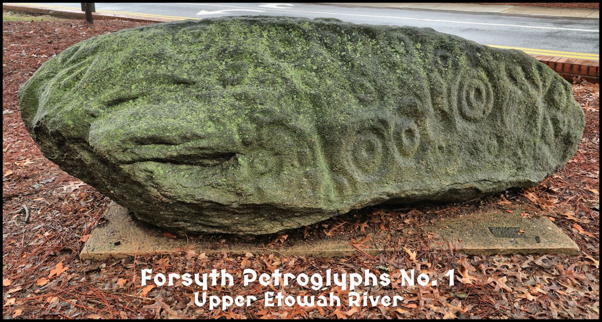
One of the boulders first noticed by white settlers in the 1830s was located on a knoll overlooking the Etowah River in Cherokee County, Georgia. It was originally part of a cluster of three boulders with petroglyphs on them. Throughout the 1800s rumors persisted that Native Americans had hidden gold under the boulders and that the abstract symbols on the boulders were used to denote the locations of ancient gold mines. At the turn of the century two of the boulders were blown up with dynamite in an effort to retrieve the mythical gold caches. No gold or anything else of value was found in the rubble of these destroyed legacies of the past.
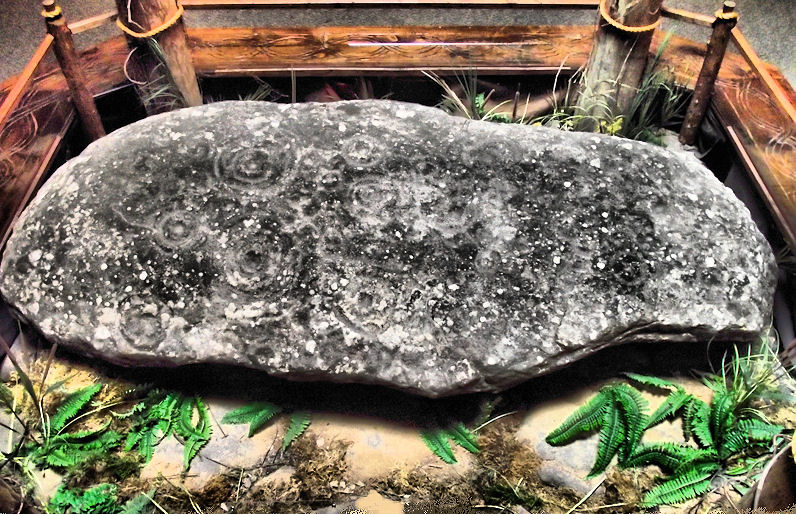
In the 1940s the Cline Family, owner of the land around the surviving boulder, donated it to Reinhardt Junior College (now Reinhardt University) in northwestern Cherokee County. The boulder is 11 feet long, 1 ½ feet thick and weighs approximately 5 tons. A larger wrecker transported the boulder to the college campus. It was originally placed outdoors between two oak trees and later moved inside the college’s library. In 1999 it was given a permanent home in the Hall of Ancients in the new Funk Heritage Museum on the college campus.
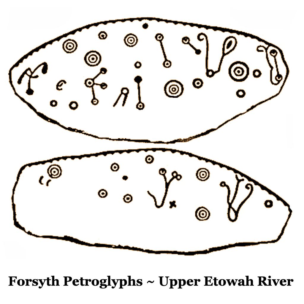
Typical motifs of the Upper Etowah River Basin petroglyphs
Most of the carvings on the Reinhardt Boulder are randomly spaced concentric circles, varying greatly in size and number of rings. One glyph has six rings, while the majority of glyphs have one or two rings. Two glyphs have crosses within them. There is at least one star-shaped glyph. There are also numerous points or small circles that could either be man-made or the result of lightning strikes. Some petroglyph specialists have interpreted several indentations in the rock as abstract, asymmetrical glyphs. However, these may actually be the result of natural erosion.
Interpretations of the purpose or meaning of the Reinhardt Petroglyphs have varied considerably. Most archaeologists, who have viewed the boulder, have felt that the carvings pre-dated the arrival of European settlers and were the work of Native Americans. The general consensus is that the rock carvings were far too old to have been done by the Cherokees. The Cherokees officially owned the region from around 1795 till 1838. Beyond the determination of the petroglyphs being quite old, there has been no consensus on their meaning or purpose.

Map of the sky?
Many observers of the Reinhardt boulder assume that it is a map of the night time sky above the boulder. The glyphs may represent stars and planets visible to the naked eye. The two largest glyphs have been interpreted as being the planet, Venus and Polaris, the North Star. The initially obvious interpretation of the petroglyphs being a star map has problems when the effect of the movement of the earth on its axis and around the sun is considered. There is also another problem, the Uchee, Creeks and Mayas used entirely different symbols for Venus and the North Star. Why was the moon not portrayed on this boulder? The locations of stars and planets change for a viewer both during the night and during the year. The view of the stars and planets as portrayed on the boulder would only be valid for a brief period two nights a year.
There is considerable variation of the size of the glyphs and the number of rings. The difference in size among heavily is not visible to a person standing on earth without the aid of a telescope and knowledge of astronomy. Rings do not appear around heavenly bodies viewed with the naked eye, except occasionally when suspended ice particles distort the light of the moon. Rings today are used by astronomical maps denote the number of planets orbiting a star; a solar system. If such was their symbolism when the boulder was carved, then it is a map of a section of the Milky Way, not of the night time Georgia star.
It has been presumed that the Uchee and Creek Indians were the long-term occupants of the region around the Reinhardt boulder. Concentric circles composed the Uchee Indian glyph for a time portal or star gate. It is possible that the carving of concentric circles was part of a ritual used by Uchee priests to go into a trance, where they thought themselves traveling in time. More commonly though, the Uchee, Mayas and Creeks carved basins into rocks then looked into the water after a pebble was dropped in. Of course, the ripple effect would be concentric rings.
The location of the boulder next to a trade path has suggested to some viewers of the Reinhardt Petroglyphs that it was a regional map to guide travelers. The concentric circles were assumed to be towns and villages. Their relative difference in size was interpreted as indicating the relative difference in size among Native American communities. Viewer failed to notice the stars and hexagons mixed in with the concentric circles.
As state earlier, the Reinhardt Boulder was originally located on a bluff overlooking the upper Etowah River. The Etowah River was an extremely important river transportation route. It the boulder was a map of communities and trade routes, why doesn’t it portray the Etowah River as one of the most important trade corridors in the region?
An astonishing discovery, while cruising the web
While researching the Province of Duhare on the South Atlantic Coast, I realized that I knew very little about either Ireland or Scotland. I began “surfing” the web for technical articles on Ireland’s and Scotland’s history. It is fascinating what we were never told in our Anglo-centric historic texts back in high school.
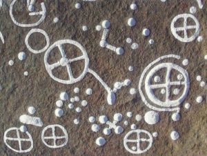
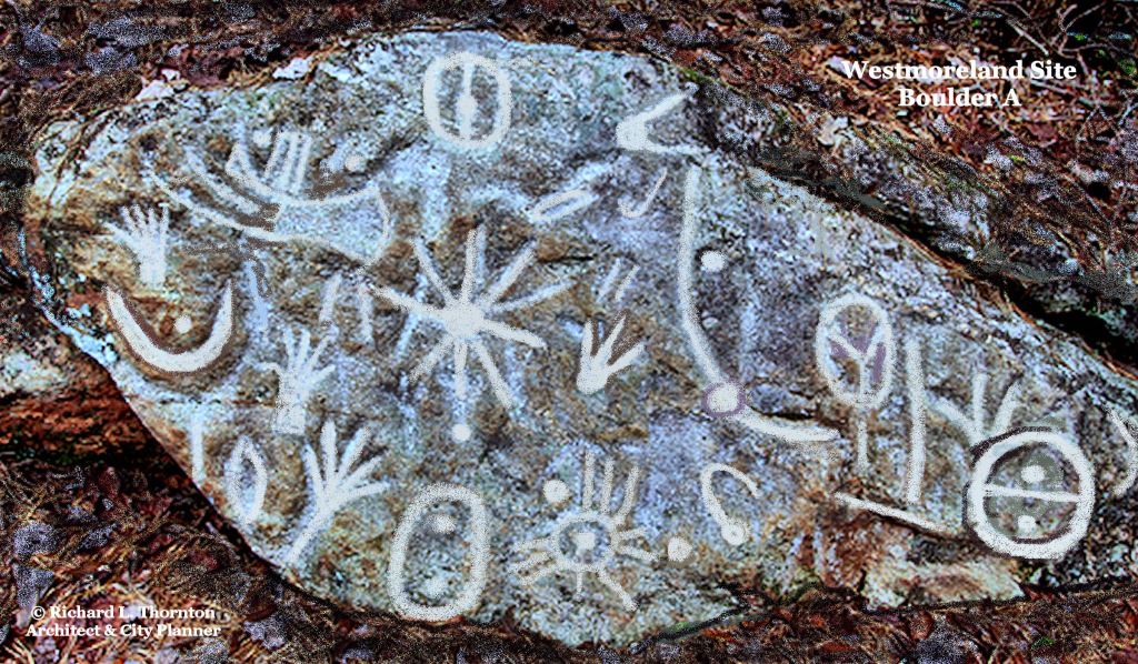
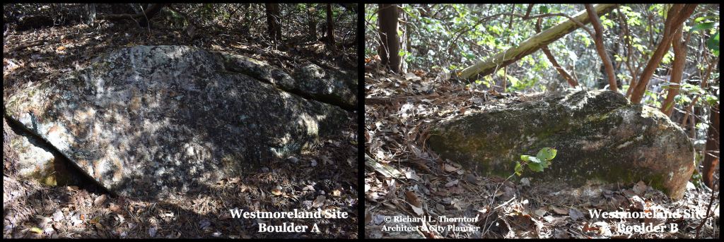
Several petroglyphic boulders have been found on the Upper Etowah and Amicalola Rivers with very similar motifs to that of the Rheinhardt Boulder. They are also identical to the petroglyphs of the Atlantic Coastal counties in Ireland, in particular Kilarney and Donnegal, plus the regions around Dundee and Stirling in Scotland. In most other regions of the Atlantic Coast in Europe, such as eastern Ireland, western France and Galicia in Spain, the concentric rings have a line drawn through them, which extend downward. These types of concentric rings can be found in the Chattahoochee River basin in Metro Atlanta. See the Sprayberry Petroglyphs above.

The petroglyphs in the Savannah, Upper Chattahoochee, Hiwassee and Nottely River Basins are quite different than those in the Etowah River Valley. They are almost identical to those found in Southern Sweden . . . even the ancient Nyköping Petroglyphs, which have been dated to 2000 BC! We will be talking about them in another article.
Conclusion

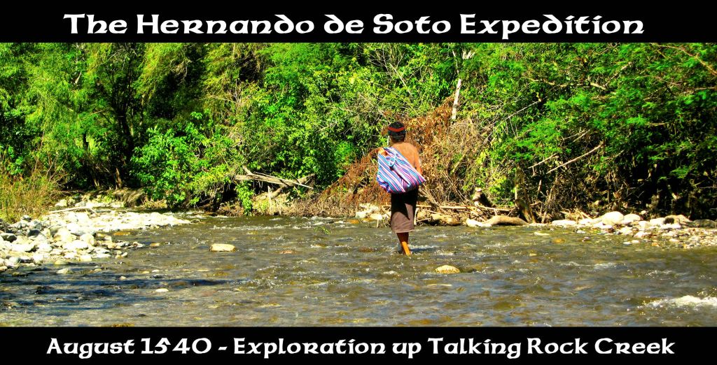
There is an intriguing account by the chroniclers of the Hernando de Soto Expedition that suggests that the descendants of the carvers of the Irish Bronze Age style petroglyphs along the upper Etowah River still survived into the 1500s. A expedition was dispatched from Kawshe (Coça ~ Kusa ~ Coosa) to travel up Talking Rock Creek to search for gold. The conquistadors and their Native guides got as far as the foot of Mount Oglethorpe, starting point for the original Appalachian Trail. The guides refused to go any farther because they said that witches lived on the tops of the Blue Ridge Mountains!
The Petroglyphic Evidence suggests that during the Bronze Age 2400 BC – 500 BC) the same ethnic group lived in certain parts of Scotland and Ireland, plus in the Upper Etowah River Valley in Georgia. Who these people were that liked to carve concentric rings, is another matter. They probably were the ancestors of the Uchee People and formed part of the genetic makeup of modern Irish and Scots. They probably were not the ancestors of modern Germanic Scandinavians. More likely they were related to the Asiatic People, who were also ancestors of the Sami People of northern Scandinavia and Basque of Iberia and southern France. Undoubtedly, these Europeans with substantial Asiatic heritage came by boat. When they came cannot at this time be determined.

my Ulster Irish, very Keltic grandmother, noted several times, that my sister & I with Creek ancestry (on other side), looked “typically pre-Keltic” or “Pre-Irish” . Because we were slight dark, like the folks in rural areas in Ireland. Seems to be true.
LikeLiked by 1 person
That is exactly what I think. There are “black Irish” in SW Ireland, who look like mixed-blood Creeks. Same thing goes for the Northern Sami. Everyone in Scandinavia, including the Sami, thought I was a northern Sami.
LikeLike
Richard, Great work on your articles. That North Georgia boulder Sunflower symbol is a connection to the Minoans of a city called Santorini… Looks like they also did cross the Atlantic: https://www.minoanatlantis.com/pix/Minoan_Miniature_Frieze_Admirals_Flotilla_Fresco_Art_Ship_Closeup_650px.jpg
LikeLiked by 1 person
One of the ships portrayed on the Tugaloo Rock looks like a Minoan ship. Two look like a Scandinavian boats, which have double prows, fore and aft.
LikeLiked by 1 person
Richard, I have no reason to believe some of the Scandinavians did not arrive to this part of the Earth in the ancient days. Many Creeks are related to them while the Cherokees are related to the Armenians, Egyptians and Berbers in DNA tests. The Armenian code in them could trace back to the city called A-tana of Turkey by the Armenians in the land once called Lu-wiya by the Hitties. Close by were the people that called themselves Kan-Ani. These groups of peoples migrated to Spain and used the suffix (Tana/ Tani) for the kingdom of the Mi-Tani or for Tanit (mother God worship). The bronze age weapons (1500 BC) seem to match the “old Bronze /copper culture” of the Great lakes and the Near middle East.
LikeLike
What an ethnic soup we are, huh?
LikeLiked by 1 person
Being adopted and searching for my heritage these past few years I have come to wonder even more. After finding my half sister several years ago we did our DNA tests. There are the British Isles, Ireland, Norway and Sweden in my mix. My sister was with our mother and knew a little of our past. She was told Native American was in the mix. Our ancestors go back on our mother’s side to the earliest 1600s colonists. Many were here in SW VA/ NE TN/ W NC since the early 1700s. Like I have said before there is a large stone along the banks of the Nolichucky that looks similar to the other concentric circle ones around the world. Definitely makes me wonder about the connections. As always I enjoy reading your articles and watching your videos Richard. I always learn something new to help me follow down my path in search of my heritage .
LikeLiked by 1 person
Oh, I think that it is quite likely that these stone circle people were up in East Tennessee. They seemed to have preferred the mountains.
LikeLike
Richard, a follow on to my last post: Thunder birds..Horned serpents…twin hero’s are connected to the Mi-Tanni peoples: https://upload.wikimedia.org/wikipedia/commons/1/1a/Mitannian_-_Cylinder_Seal_with_Two_Heroes_and_a_Tree_-_Walters_42992_-_Impression.jpg
LikeLike