by Richard L. Thornton, Architect and City Planner
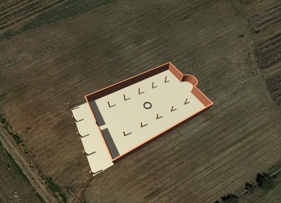
Habersham County, GA ~Dec. 12, 2019 – Just back from the archaeological site! Infrared imagery detected the distinct footprints of three mounds overlaying each other and rectangular buildings. However, the corn has been harvested now and a big surprised was revealed. The walls of both the large rectangular building footprints and the smaller rectangular footprints are lined with stones. At least one stone contained a cylindrical slot in which to place wooden posts.
While buying produce from a farm market near the Fritichey Archaeological Site, the farmer happened to mention to me that he had always wondered why there were lines of stones in the ground. Supposedly, the Georgia Department of Transportation had scrapped away a 40+ feet high hill in 1993. He also mentioned that over the years, he had plowed up bones . . . “some of them probably human.” This is a game changer.
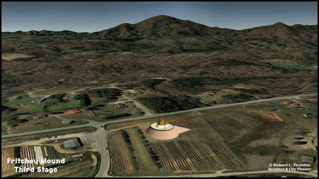
Recap of previous articles: In 1993, the Georgia Department of Transportation purchased what they thought was a hill adjacent to GA Hwy. 17 between Clarkesville and Helen, to use as road fill on an expressway in the eastern section of the county. The hill was razed then continued to be utilized for cultivation of crops by the owner.
It is a similar situation to the nationally publicized destruction of a large mound in Oxford, Alabama during 2009. Habersham County officials are consistently pro-historic preservation because it is essential to the county’s tourism industry. They were not told about the planned activity by the GDOT and were not aware that it was an archaeological sites. The GDOT apparently followed federal and state mandated Section 106 procedures that requires a site to be studied for potential cultural features, both historic and prehistoric. The consultant firm or state employee, who filled out the forms for Section 106 did not bother to actually visit the site. If they had, they would have noticed that the “hill” was a symmetrical oval, 40-50 feet high, with a very large ramp extending westward from the mound.
The farmers, cultivating the newly leveled property, immediately noticed many artifacts appearing on the surface, which included potsherds, stone tools and bones. The archaeologists at the Officer of Historic Preservation were contacted, but they declined to visit the site or look at the artifacts.
In the late summer, Mr. Allen Fritchey, who sells produce grown on this tract, asked me to take a look at the site because of the continuing appearance of what appeared to be Native American artifacts. I could see nothing on the surface of the beige colored soil that suggested human occupation, but went a further step and used remote sensing techniques to analyze it. I was astonished to see distinct footprints of three mounds, one built on top of another, plus at least eight rectangular footprints of buildings and what appeared to be a tomb or altar in the center of the largest rectangular building.
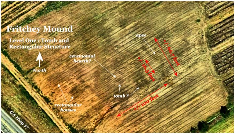
Some stones are visible on the surface of the field and they do align, except on the southwest side of the largest rectangular footprint. The farmer stated that over the years his deep chisel plow has hit stones and kicked them aside. A type of remote sensing other than infrared and LIDAR must be used to determine the locations of the remaining stone walls. This type of device senses the relative density of objects under the ground. It is significant more expensive to implement than infrared scans.
Apparently, when the bulldozers tore into the large mounds in 1993, they scooped way both the artifact-rich soil and the stone wall. What is visible now are the remnants of the wall or its foundation.
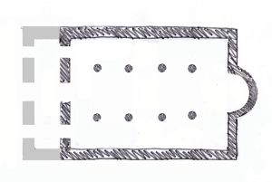
A stone temple and timber framed temple were discovered under Mound C at Etowah Mounds National Historic Landmark by archaeologist Lewis Larson. He showed our Introductory Anthropology class at Georgia Tech slides of these temples, but no mention is made of them at the current exhibits in the Etowah Mounds Museum. A cut-away drawing of Mound C only shows dirt. Archaeologists also found a six feet high stone retaining wall around the great plaza at Etowah Mounds. This is also not shown in the museums exhibit.
Sun God temple in Cádiz, Spain
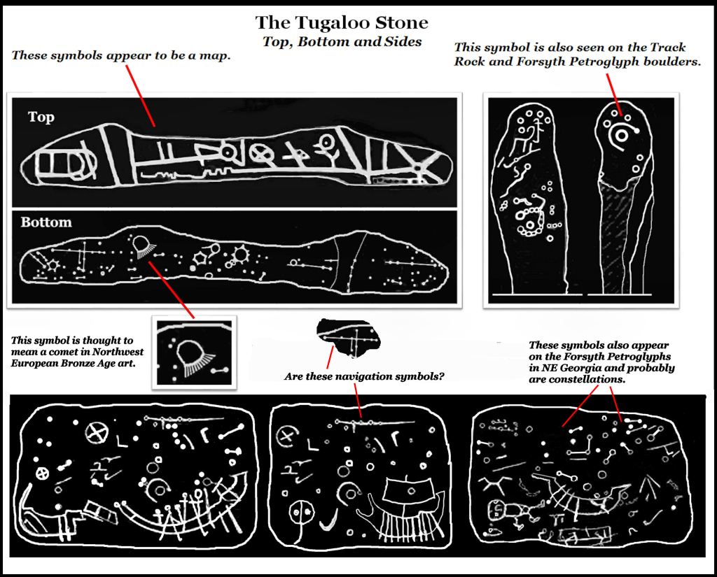
Since we now know that the largest rectangle at the Fritchy Site is a stone-walled building, there appears to be no difference between it and a Late Bronze Age temple constructed in Cádiz, Spain. This is not so implausible as it seems. The Fritchey Site is located on an ancient trade route, which begins on the Tugaloo River in Stephens County, GA, about 21 miles to the east of there. The carved stone block was discovered by laborers aroun d1795 and is on display at the Travelers Rest State Historic Site near Toccoa, GA. On this rock are carved many Bronze Age Scandinavian navigation symbols plus at least four Bronze Age ships. The truth is out there somewhere!

I find this extremely interesting Richard. You have been finding and putting together pieces to the giant mystery puzzle of the past that is scattered all across the Southeast U.S. I also believe that there is more than what has already been discovered here in east TN at the recent Cane Notch Site and the early 1980s Plum Grove Site. Many mysteries are in these areas that connect to each other and have been farmed continually for centuries with many artifacts including pot shards, stone tools and bones arising to the surface with each consecutive crop over the years. My father-in-law walked the grower’s fields with the owners permission for over the 30+ years I knew him always finding some artifacts each time he went out. Unfortunately after his passing most every item disappeared among his children that never really cared. He would have been extremely upset by that lust for them because most of his children didn’t care much about his findings or their Native American ancestry when he was alive. He could tell you about each piece and where he found each one. I only have 3 that were given to me that I have treasured for many years. Along with memories and stories told by him.
LikeLiked by 1 person
Oh, I am sure there is much undiscovered in NE Tennessee. It has hardly been touched by the archaeologists. That is where the Chiska were based. They were metallurgists from South America. Also, we have eyewitness accounts of brick town occupied by Armenians or Anatolians, a wooden town occupied by Africans and the ancient Sephardic Jewish villages visited by Col. John Tipton and Col. John Severe in the 1780s.
LikeLiked by 2 people
Yes I am sure there is plenty to be discovered around my neck of the woods Richard. They have barely scratched the surface and do not interrupt findings properly to get the clearer big picture. They are narrow minded and stuck on that there Cherokee thang. I was told by my father-in-law that there was a silver mine in the mountains nearby. He looked for it during his lifetime. He was certain it was there. My brother-in-law and I hiked several times in the mountains way back in the 70s following his directions looking for it. We never found it but I have a better idea now since reading your articles for years and searching for clues on old maps along with my father-in-law’s hints. It’s there tucked away. Which goes along with the Chiska being metallurgists. Not only that but there are many documented iron and lead mines very close by that supplied metal during the Revolutionary War. The trifecta of Colonels Sevier, Tipton, and Love surrounded the mountain range that contained the iron and lead mines here in a triangle. Col. Tipton at the point, Col. John(Chucky Jack) Sevier with his second wife and family were on the Nolichucky at Plum Grove ( Sherrill Cemetery is there) on one side and Col. Robert Love was at Greasy Cove (Unicoi County and there is family still on some of the original property now I know them) on the other side of the mountain also on the Nolichucky.
LikeLike
Simply…WOW!
On Thu, Dec 12, 2019 at 12:41 PM The Americas Revealed wrote:
> alekmountain posted: ” by Richard L. Thornton, Architect and City Planner > Habersham County, GA ~Dec. 12, 2019 – Just back from the archaeological > site! Infrared imagery detected the distinct footprints of three mounds > overlaying each other and rectangular buildings. Howe” >
LikeLike