
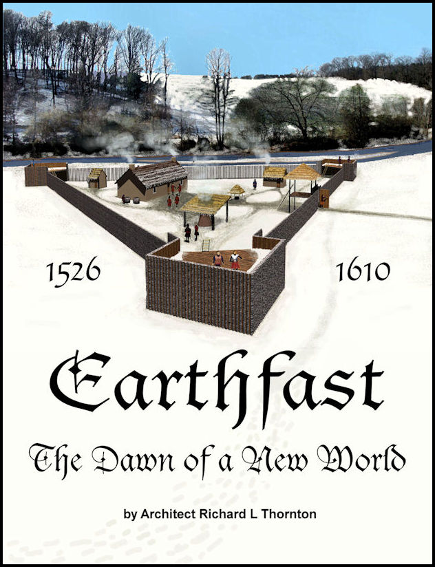
by Richard L. Thornton, Architect & City Planner
Most of these early colonial ventures are never even mentioned to students in the United States.
Fifty years ago . . . It has been an week of non-stop family fiestas in Mexico, which climax with Hallyboo’s graduation from high school tomorrow. In the day time, I have been studying exhibits at the Museo Nacional de Antropologia. On Saturday, July 4th I get to see my first Aztec pyramid, Tenayuca. We’ll get back to the “One Summer in Mexico” Series on the Fourth!

Ever heard of Charlesbourg? Mellilot? Tadoussac? St. Croix? Ville de Port Royale? These were all colonies established by Frenchmen BEFORE either Jamestown or Plymouth Plantation. Charlesbourg (1540) only lasted two years, but Mellilot was occupied from 1566 till at least 1696. These ventures by Frenchmen have been left out of the history textbooks of the United States. For unknown reasons, US history textbooks are far more likely to mention colonial efforts by the Spanish.
Of course, while practicing architecture in Virginia, I worked on many Colonial Era buildings, my own home included. However, of the 88 structures, the oldest was only built in 1746, when the Valley was mostly uninhabited. It was a stone structure on the Shenandoah River near Strasburg, built by an odd semi-monastical Protestant sect from Ephrata, Pennsylvania called the Mystischer Orden der Einsamen (Mystic Order of the Solitary).

My interest in the architecture of the very earliest North American colonies began with a commission in 2007 from the American Museum of Natural History to prepare 3D architectural drawings from archaeological reports on the Mission Santa Catalina de Guale (c. 1600 AD) on St. Catherines Island, GA. There were questions that the evidence under the ground couldn’t answer . . . How did the Spanish build the wood frames for their mission buildings? I quickly discovered that there were also no architectural references on 16th and 17th century colonial structures in North America.
For the next seven years, I worked on solving that need. I quickly discovered that there were several French and English colonies, which were NEVER mentioned in my history books from high school and college. I also discovered that of all things, the history courses that the US Navy taught me were the most useful experiences for re-creating 16th and 17th century fortifications.
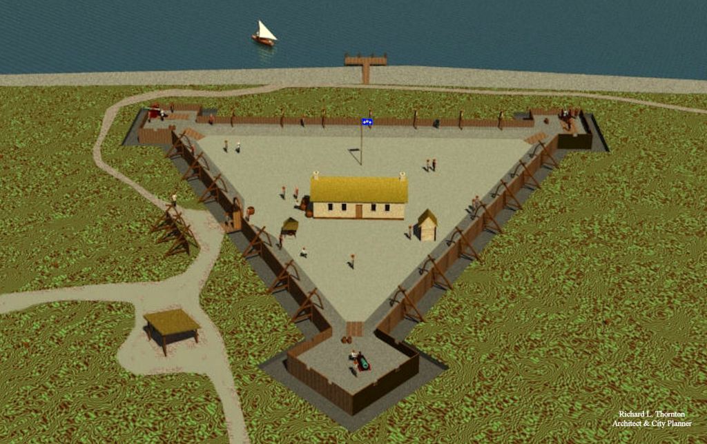
All illustrations in this article come from Earthfast . . . the Dawn of a New World. Because the book contains hundreds of full color architectural renderings, the printed version is pricy ($77) on Amazon and Barnes & Noble, but you can download a PDF from the publisher, Lulu Press, Inc. (www.lulu.com.) for $15. In this article, the description of each colony will be brief, but there are entire chapters on them in the book. The book covers all French, Spanish and English colonial efforts in North America between 1526 and 1610.

Charlesbourg-Royal (1540-1543) [Quebec]
The earliest French explorers of the St. Lawrence River established a fortified campsite on a large hill in 1540. In the summer of 1541, after arriving on his third and final voyage, French explorer Jacques Cartier established the fort and a settlement of 400 people at that site. It consisted of an upper fort, and lower fort located near the confluence of Rivière du Cap Rouge at the north shore of the Saint Lawrence River. During the first winter, 35 of Cartier’s men perished. Fort Charlesbourg Royal was abandoned in September 1543 due to the harsh weather, scurvy, and attacks from the nearby Native American village of Stadacona and other villages.
Charlesfort (1562-1563) [South Carolina]
Charlesfort was established when a French expedition, organized by Huguenot leader Admiral Gaspard de Coligny and led by the Norman navigator Jean Ribault, landed at the site on the May River in February 1562, before moving north to Port Royal Sound. There, on present-day Parris Island, South Carolina, Ribault left twenty-eight men to build a settlement. Ribault then returned to France to arrange supplies for the new colony but was arrested in England after becoming involved in the period of unrest known as the French Wars of Religion, which prevented his return.
After Ribault left, most of the settlers’ stores were burned, and Captain Albert de la Pierria died in a mutiny, possibly as a reaction to his heavy discipline. Without supplies or leadership, and beset by hostility from the native population, all but one of the remaining colonists sailed back to Europe after only a year. They built their own boat and set sail, without compass, across the Atlantic. During the long voyage in an open boat, they were reduced to cannibalism before the survivors were finally rescued in English waters by an English ship, and some eventually reached France. Shortly after the colonists’ departure, Hernando de Manrique de Rojas commanded a Spanish force from Cuba that destroyed the French fort, and took captive the one Frenchman who had remained with the local Native Americans nearby.

Fort Caroline (1564-1565) [Georgia]
Fort Caroline was a massive fortification, constructed in 1564, in anticipation of 900 more French colonists arriving in the late summer of 1565. It initially contained over 300 residents. It was intended to be a town so large and so thoroughly armed with artillery as to be impossible for the Spanish to dislodge it. However, the Capital of French Florida was to be approximately where the University of Georgia campus is today in Athens, GA. This location was chosen in order to be close to the Georgia Mountains Gold Belt. Fort Caroline was massacred then razed by Spanish forces in late September 1565. This was made possible because most of the soldiers in Fort Caroline were on ships, looking for the Spanish fleet.
The current location of Fort Caroline National Monument in Jacksonville, FL is probably the biggest scam ever foisted on the American public. The “Fort Caroline” that tourists visit today is an inaccurate 1/12th scale model of the real Fort Caroline, which was built in 1962 with discretionary funds to reward the congressional district around Jacksonville, FL for supporting the first Civil Rights Act. In reality, the St. Johns River was not even accessible to ocean-going vessels until 1860!
I first became aware that something was terribly wrong in 2007. The American Museum of Natural History sent me a box full of photocopied Spanish archives associated with Mission Santa Catalina de Guale, which was immediately north of the Altamaha River. Over and over again, I read eyewitness accounts by friars and Spanish officials that placed the ruins of Fort Caroline and Fort San Mateo on the southside of the Altamaha River (initially called Secco by the Spanish) several miles inland.
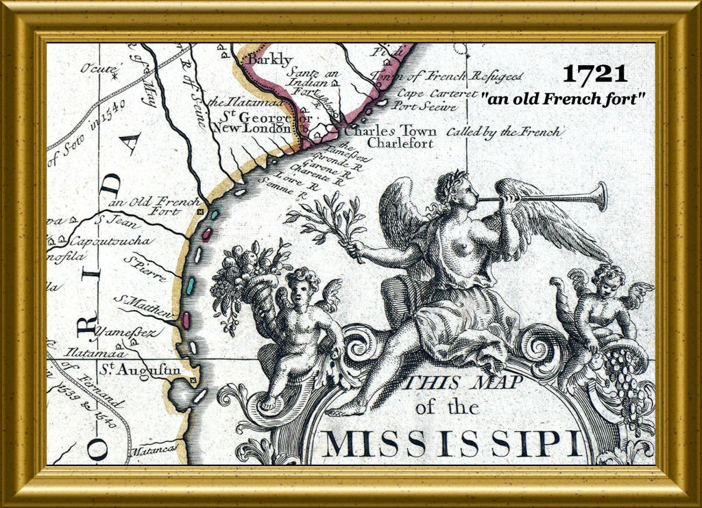
All French and Spanish colonial archives . . . all French, Spanish, English, Dutch and German maps . . . labeled the Altamaha River of Georgia as the May River and the location of Fort Caroline on that river until 1722. William Bartram even visited the site of Fort San Mateo in 1776 and mentioned it in his book! France never claimed land south of the St. Marys River. The border between French Florida and Spanish Florida, the St. Marys River, became the border between Georgia and Florida. In 1721, South Carolina changed the name of the river from May to Altamaha to conceal the claim on that region by France.
The phony location of Fort Caroline and the myth of the Fountain of Youth in St. Augustine were created by a real estate speculator from New York in the mid-1800s, who bought large tracts of land in both locations. Since there was no location near Jacksonville with 16th century French and Spanish artifacts, the City of Jacksonville arbitrarily bought a 25-acre tract with a good view of the river and gave it to the federal government in 1950 in order to create a Fort Caroline National Park. Suspecting that the location was bogus, Congress balked at the national park designation, but initially agreed to accept the land for a “memorial” to the French Huguenot colony . . . which for the next 12 years was a wooden sign.
Read Wikipedia today. It tells you matter of fact-ly that Fort Caroline was in that specific location and does not tell you that what you see in the photos is an inaccurate fake. Essentially, what was built was a putt-putt golf course with miniature timber walls around it – not a fortified town of 1000-1200 people.
Florida academicians are knowingly perpetuating the fraud. I caught the University of Florida History Department with changing the latitudes of Fort Caroline and the original location of St. Augustine on St. Andrews Sound, Georgia in the supposed “English translation” of an October 1565 report to the King of Spain to match the fake location of Fort Caroline. St. Augustine moved south 100 miles to its current location in March 1566, because of the large numbers of hostile Native Americans in Georgia. Also, recently someone changed the maps on the Wikipedia articles on Charlesfort and Fort Caroline. They now use a 1763 map, used in the peace negotiations between Great Britain and France, which vaguely shows Fort Caroline, somewhere in SE Georgia, but labeled it as a map produced in 1562!

My drawings of Fort Caroline are based on the very detailed information in the original French language memoirs of Captain René de Laudonnière, plus LIDAR and infrared imagery, provided by the Glynn County, GA Planning Department. If you want to know more, please watch the two videos below.

Mellilot (1566-c. 1700) [Georgia]
According to 17th century historian Charles de Rochefort, 10 colonists were away from Fort Caroline when it was massacred. Six of those colonists were able to make their way up the Altamaha and Oconee Rivers, where they were given sanctuary by the High King of Apalache in the Apalachen Mountains. Those six Frenchmen established a town for Europeans at what is now called Little Mulberry River County Park. It attracted many more Protestants and Jews. Mellilot appeared on European maps from 1570 to 1700. I have a copy of a letter written by one of its directors, Edward Graeves, that is dated January 6, 1660.
I had planned to prepare measured drawings of the very visible quarried stone foundations of European style houses in Little Mulberry River Park. However, that project is on hold until the pandemic goes away.
Tadoussac (1599-Present) [Quebec]
Tadoussac was founded in 1599 by François Gravé Du Pont, a merchant, and Pierre de Chauvin de Tonnetuit, a captain of the French Royal Navy, when they acquired a fur trade monopoly from King Henry IV.[6] Gravé and Chauvin built the settlement on the shore at the mouth of the Saguenay River, at its confluence with the St. Lawrence, to profit from its location. But the frontier was harsh and only sixteen of the initial 50 settlers survived the first winter.[7] In 1603, the tabagie or “feast” of Tadoussac reunited Gravé with Samuel de Champlain and with the Montagnais, the Algonquins, and the Etchimins.” In 1615, the Mission of L’Exaltation-de-la-Sainte-Croix-de-Tadoussac, named in memory of a cross planted by Jean de Quen, was founded by the Récollet Order.

St. Croix (1604) [Nova Scotia-Maine]
On November 8, 1603, Henry IV of France granted a Protestant nobleman, Pierre Dugua, Sieur de Mons, a monopoly for the conduct of the fur trade and the title of lieutenant governor of the territory between the 40th and 46th parallels known as La Cadie. In return, De Mons was expected to colonize the country and convert the First Peoples to Christianity. Prominent members of the expedition included the explorer/geographer, Samuel Champlain; the Sieur de Poutrincourt, who had a special interest in farming; and François Pontgravé, who, like Champlain, had been involved with an expedition up the St. Lawrence the year before. De Mons also brought along a surgeon, a miner, a Roman Catholic priest and a Protestant (Huguenot) minister to look after the spiritual needs of the colonists. The group included a sizeable contingent of Huguenots.
The expedition sailed from Havre de Grâce (now Le Havre), France in March 1604. Arriving at Sable Island on May 1st, they divided-up; three ships headed up the St. Lawrence to trade, Pontgravé sailed for Canso, and De Mons, Champlain, and Poutrincourt explored the coast of Nova Scotia and the Bay of Fundy. Throughout the summer De Mons searched for an appropriate site for a settlement while Champlain carefully mapped the inlets and harbors of the rugged coastline.
At the end of June, after exploring the mouth of the St. John River, the group arrived at Passamaquoddy Bay. Here they found an island situated inland near the confluence of three rivers. Blessed with an abundance of resources, especially herring and bass, and easily defended against possible attack, it seemed a promising site for a settlement. De Mons named the island Île-Sainte-Croix.
The snow came early that year. The situation of the colony quickly changed. During the first winter there more than half the settlers had perished due to a “land-sickness” believed to be scurvy. The following spring, Champlain and François Gravé Du Pont moved the settlement to a new location on the southern shore of the Bay of Fundy Champlain had found during a shoreline reconnaissance there for a more suitable site. Called Port-Royal, it became the first permanent European settlement in New France.

Port Royal (1605) [Nova Scotia]
Port-Royal was founded after the French nobleman Pierre Du Gua de Mons who spent a disastrous winter in Île-Saint-Croix. He was accompanied by Samuel de Champlain and Jean de Biencourt de Poutrincourt et de Saint-Just. They decided to move their settlement to the north shore of present-day Annapolis Basin, a sheltered bay on the south shore of the Bay of Fundy which had been recorded by Champlain earlier in the spring of 1605 during a coastal reconnaissance.
The colonists constructed a log stockade fortification called a “habitation.” With assistance from members of the Mi’kmaq Nation and a local chief named Membertou, coupled with the more temperate climate of the fertile Annapolis Valley, the settlement prospered. After its destruction by raiders from Virginia in 1613, Port-Royal was re-established on the south bank of the river 8 km (5.0 mi) upstream. The British renamed Port-Royal at this new location as Annapolis Royal following their conquest of Acadia in 1710.


Many holes in American history that is taught in America’s schools is a Giant Understatement in my opinion Richard. After searching for my true heritage (I was an adopted child) over the last 10 years I have learned a considerable amount of information that I was never taught in school growing up. From reading your many articles for years and researching on my own I have been astonished by the lack of True American History that is omitted. Even after returning to college several years ago I found that evident in the early American history classes I took. My professor was surprised and amazed by the questions I posed to her along with the information I presented in my projects and in class. Keep on spreading the Truths that are out there Richard. We ALL Need to learn the Truth. Thank you for enlightening us with your knowledge and insight of the past, present, and future with your research and prospective.
LikeLiked by 2 people
Thank you for your many kind comments. I am trying to steadily improve the professional aspects of my research and articles. We’re getting there!
LikeLike