
by Richard L. Thornton, Architect and City Planner
Most emphatically, YES!, but there is virtually nothing in the national and international professional literature about it. It is a similar problem to he one, which we addressed back in 2014 and 2015. Several books had been recently published on petroglyphs and pre-Columbian stone structures in the United States. They completely left out the petroglyphs and stone structures in the Southern Highlands, where there are by far the greatest concentration of ancient stone ruins. We asked readers to go out in the boonies to document these vestiges from the past. You sent in photos and GPS locations for 78 sites in the Southeast. I then forwarded the GIS map to the National Park Service.
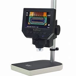
I now have a 1200X power digital microscope . . . the type used by geologists and archaeologists, which connects directly with my computer via a USB cable. I can store the photos and videos in my computer or in external data storage device.
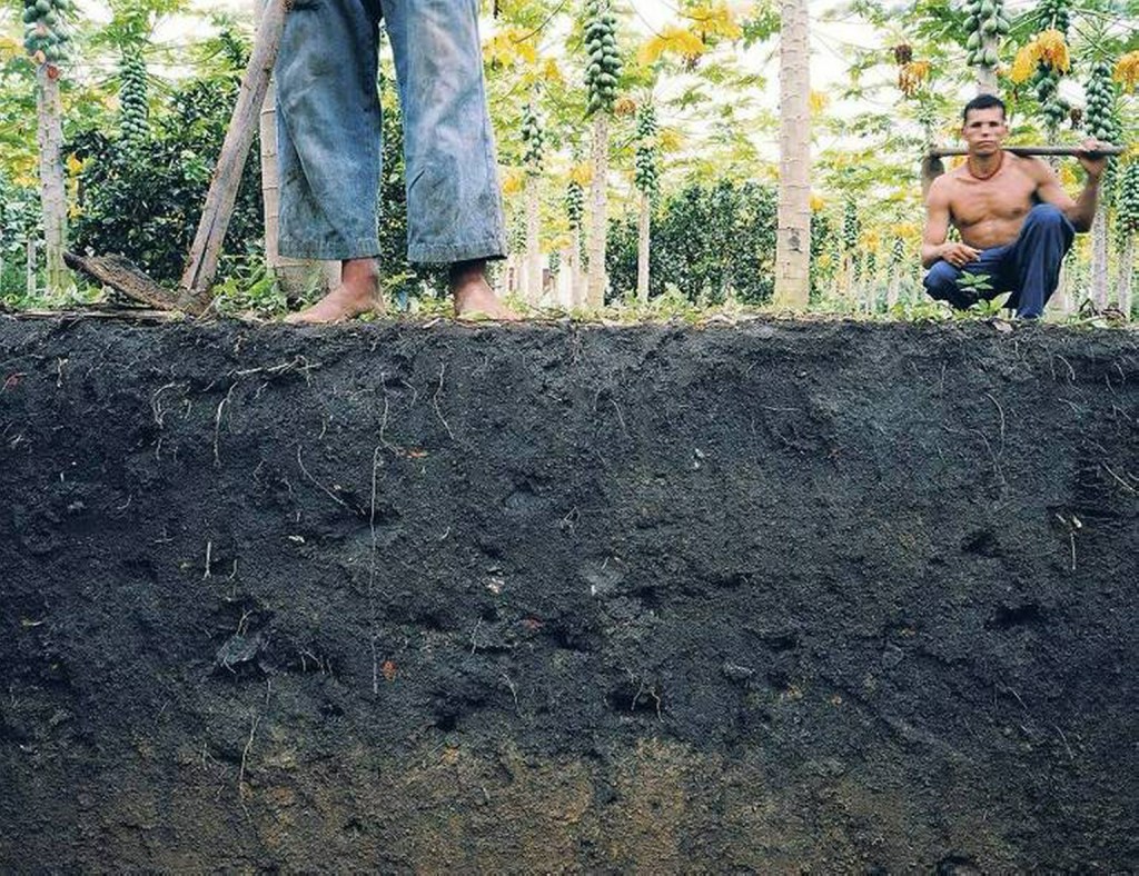
Currently, I have three “terra preta” soil samples. Registered Land Surveyor and Archaeologists, David Barrow, sent me a sample from an agricultural platform on his property in Key West, Florida. Using my infrared camera, I also found two terra preta platforms in the Amy’s Creek Valley between my house and the Alec Mountain Stone Oval. These two agricultural sites provide multiple (and quite bountiful) vegetable crops a year for Fritchey’s Gardens Farm Store on Highway 17 in Habersham County, GA.
If you know of an artificial platform mound with unusually black soil in it or a Pre-Columbian agricultural terrace complex in your area, could you obtain about a cup of sample soil and forward it to me for analysis? The agricultural platform mounds are generally no more than six inches to three feet in height above the existing grade. Dig down at least a foot to get a sample. Put the soil in a ziplock plastic bag or plastic jar.
What is terra preta or biochar soil?
Meaning “black soil” in Portuguese) is a type of very dark, fertile artificial soil that was originally identified in the Amazon Basin. It is also known as “Amazonian dark earth” or “Indian black earth”. In Portuguese its full name is terra preta do índio or terra preta de índio (“black soil of the Indian”, “Indians’ black earth”). This type of soil appeared between 450 BCE and 950 CE at sites throughout the Amazon Basin.
Terra mulata (“mulatto earth”) is lighter or brownish in color. This is the name used in Brazil for the soils of the villages that surrounded the terra preta platform mounds.
Terra preta owes its characteristic black color to its weathered charcoal content, and was made by adding a mixture of charcoal, bone, broken pottery, compost and manure to the low fertility Amazonian soil. A product of indigenous soil management, slash-and-char, plus the replicative application of garbage and human urine/excrement to the site, the charcoal is stable and remains in the soil for thousands of years, binding and retaining minerals and nutrients.
Scientific research identified the complex composition of terra preta soils very early in the first decade of the 21st century. However, this information was not generally known internationally until writer, Charles C. Mann, published his best-seller, 1491: New Revelations of the Americas Before Columbus in 2005. Several TV documentaries were based on his book. (See below.)
Virtually all media sources in the United States define terra preta as an agricultural technique peculiar to the Amazon Basin in Brazil, Peru and Ecuador. However, immediately after their subjugation of Mexico, the Spanish were aware that indigenous farmers in the lake basins of Central Mexico created artificial top soil on man-made islands, while the indigenous peoples of southern Mexico typically raised most of their vegetables on raised beds, composed of artificial top soil. Farmers in the mountainous regions of Chiapas State, Mexico and Guatemala created artificial top soil in mountainside terraces. In fact, the practice was so endemic in the southern 2/3 of Mexico, academicians never thought it useful to analyze said soil.
In 2001, New South Associates, a highly respected cultural resource consulting firm in Stone Mountain, GA, was asked by archaeologist, Johannes Loubser, to analyze soil samples taken from three rock-walled terraces in the Track Rock Terrace Complex, Union County, GA. They found the black soil to be identical in content to the description of terra preta in paragraph 3. However, terra preta would not be known to most North American archaeologists until 2005. The carbon deposits of the soil dated to around 1018 AD or later. The potsherds in the soil were typical of the Middle and Late Woodland Period in North Georgia. The botanist and anthropologist, employed by New South Associates, assumed that the terraces were used for agriculture, but were not aware of the special bio-chemical characteristics of soils containing, charcoal, potsherds and kitchen refuse.
Johannes Loubser included the New South Associates report in his archaeological report to the US Forest Service. However, by 2012, Loubser was describing the 300+ terraces at Track Rock Gap to be platforms, where Cherokee chiefs performed sacred dances. Until 1785, Track Rock Gap was within the boundaries of the Creek Confederacy.

Eye Witness Accounts
Captain René de Laudonnière, commander of Fort Caroline, stated in his 1574 memoir that most of the soils along the South Atlantic Coast were unsuitable for agriculture. The two exceptions were the deltas of the Grande (Savannah) and May (Altamaha) Rivers, which contained minerals from the mountains that were vital for the cultivation of corn. Otherwise, the Indians grew their crops in garden plots, where there was a certain type of soil that would sustain vegetables, roots and grains. He said that there was virtually no agriculture on the coast south of the St. Marys River.

During the late 1500s and early 1600s, Spanish friars at missions on the Georgia coast stated exactly the same thing as De Laudonnière. Most of the Indians had three homes. Their largest home was in a town or village. Their second home was smaller and located at a farmstead next to a patch of soil that would grow vegetables. The Indians annually added human waste, ashes, charcoal, shells, broken pottery and kitchen refuse to these gardens, thus creating a raised bed of black, fertile soil. The third home was a hut at a fishing camp, next to a tidal river or creek on the west sides of islands or the edge of the mainland, next to tidal marshes. (In 2007, the American Museum of Natural History required me to read numerous documents from the Spanish Colonial Archives, prior to preparing architectural drawings of the Mission Santa Catalina de Guale on St. Catherines Island, GA.)
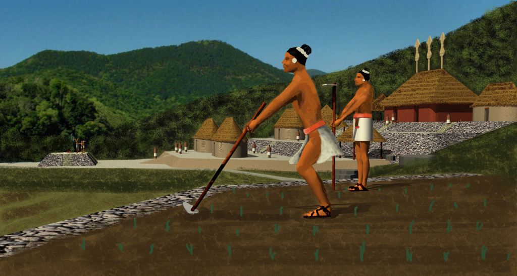
In 1773, William Bartram encountered massive platform mounds, containing man-made black soil, in the flood plain of the Savannah River near Fort James (now near Elberton, GA). This was the location where my mother’s Creek-Uchee ancestors lived from 1763 until the early 20th century. It was the location of the Creek town of Wahasi, prior to the late 17th century, but was called Ruckers Bottom by white settlers and Rembert Mounds by archaeologists. As can be seen in the rendering above, the large town also contained ceremonial and domiciliary platform mounds.
Bartram described the mounds in 1773 as: “an imposing group of one large and several smaller mounds standing adjacent to some extensive tetragon terraces, containing black soil.” The agricultural mounds varied between 3 and 12 feet in height, 100-200 feet wide and 100-500 feet long.
In 1848, George ‘s Historical Collections of Georgia claimed “the smaller mounds had been nearly destroyed.” Then, Charles C. Jones, Jr. in his book, Antiquities of the Southern Indians, stated that “only traces of the smaller mounds remained and the tetragon terraces were no more than gentle elevations.” Less than 10 years later, in 1886, John P. Rogan excavated part of the site under Cyrus Thomas and found only the largest mound and one of the smaller mounds still standing.
At the end of the American Revolution, the young state of Georgia offered free tracks of land to Patriot veterans. Many thousands of people poured into Northeast Georgia. The settlers quickly learned that the terra preta of the agricultural platforms worked wonders as fertilizer for their gardens. Within a few years, mule wagons had hauled away most of the visible agricultural platforms, leaving black footprints in the flat landscape of the Savannah River floodplain.

In 1939, archaeologist Robert Wauchope visited the site of Wahasi. He was able to measure the footprints of several mounds and took samples of the black sample. His book, Archaeological Survey of Northern Georgia does not say what he did with the soil samples.
In 1948, archaeologist Joseph Caldwell went to the wrong archaeological site . . . downstream from the proposed dam location at a site that locals call the Elbert Mounds. Generations of Georgia archaeologists have been taught information about his work there, not knowing any better.
My Uncle Uncle Hal took several of us the real Rembert Mounds in 1967. It was three miles north of the planned dam construction site. There were significant remnants of most of the ceremonial mounds, but the agricultural platforms were merely black footprints. Elbert Mounds, where Caldwell went 19 years earlier didn’t have any black footprints.
There is no doubt that the Creeks knew how to grow topsoil. I don’t remember my grandparents ever throwing pieces of pottery into their garden behind the house, but they did constantly throw kitchen waste, charcoal, ashes, sea shells, bones and the morning contents of chamber pots into the garden. When I was a kid they replaced the outhouse with a bathroom off the back porch. However, there was no heat in the bathroom, so in the winter they usually kept a chamber pot under the bed.
I strongly suspect that with the help of The Americas Revealed readers, we are going to find several other sites in the Lower Southeast, where the Native Americans “grew” terra preta. We wish you the best of hunting for them!
The following was the first TV documentary to introduce the discovery of terra preta in the Amazon Basin. In my opinion it is still the most entertaining of those documentaries.

Howdy, ONE GREAT DIGGG!!!!!!!!!!!!!!!!!!!!!!!!!!!!!!!!!!!!!!!!!
On Sun, Jan 31, 2021 at 3:55 PM The Americas Revealed wrote:
> alekmountain posted: ” by Richard L. Thornton, Architect and City Planner > Most emphatically, YES!, but there is virtually nothing in the national and > international professional literature about it. It is a similar problem to > he one, which we addressed back in 2014 and 20″ >
LikeLiked by 1 person
Thanks for this very interesting post Richard. I wish we had some of the black soil here.However ,we do create our own type of fertilizer which we call a compost from Kitchen waste,such as egg shells, potato peelings and the outer leaves from cabbage, and other greens which are not usable to cook.
LikeLike
It is the addition of potsherds and low temperature charcoal, which creates an environment for a special type of bacteria that radically changes the chemistry of soil. At my previous cabin site, I turned red clay into black topsoil in three years!
LikeLiked by 1 person
Have you analyzed any of the Trackrock site? Especially that portion south and east of the road. 34°52’40.95″N 83°52’27.02″W I spent some time in here early Jan and found many stone foundations. Also flat areas that looked to be hewn man made. Not to say logging may have had a hand in this. The dense cedar stands seem to indicate good growing soil. If you have not been in this area let me know. I will send you some soil samples. That is if I can locate promising signs. If you look on GE you can make out some faint lines that appears to be architectural walls of some sort. My eye is not trained so it is difficult to distinguish between logging intrusions and true terracing. Would love to start populating the Union County Historical society archives with the missing Creek culture. Visitors only see Cherokee history. Not right!
LikeLiked by 1 person
Could you take photos of those stone foundations? If you see black earth, I do want a soil sample. When Track Rock Gap Road was reconstructed in the late 20th century, many tombs were found along the right of way. They contained Mesoamerican type artifacts. The workers had a brisk business selling the artifacts to buyers from Metro Atlanta, who then sold them to collectors and galleries as Mexican artifacts. My legs are finally recovering from being struck by lightening 18 months ago. I will be able to do some hiking by late winter or early spring. Thank you! for this very important information.
LikeLike
I have some significant information for you regarding lightening. Remember the mountain of the petroglyphs is labeled “Thunderstruck Mountain”. Petroglyphs at trackrock align with the stars and planets and sun. This is an observatory where ancients could watch for shifts in alignment to warn them of the coming magnetic excursion that earth cycles every 12K years. Myans knew of it in their calendars. Increase in lightening in the artic indicates we are into the cycle. The sun is onto its grand solar minimum. Our magnetic poles are shifting as we speak. This trackrock land is valuable for our survival as you ancestors knew of it. I will be going back to the site mid Feb to look for better evidence. Our second home is 10 minutes away from the site. Have Video of foundations. where send?
LikeLiked by 1 person
Communicate with me on this matter via our email, PeopleOfOneFire@aol.com. This is a public comment page, which anybody can read.
LikeLike
Where would I send the soil sample should I find something? Or would you like to meet at the site and we can look together. You are welcome to stay at our place during any visit.
LikeLike
Okay after several months of investigation I have found soil samples are critical! What we have here is living archeology. I am sending multiple soil samples to Richard from confirmed and unconfirmed mounds. Remember these ancient people were the best soil scientist in the world because… They had to be. Their track record is impeccable as to raising crops years after year. the lands where we find their ruins and remnants have crop growth that is beyond all yields to this day. I can attest to this in the area I live. No artificial fertilizers. However the soils are ancient and contain the elements Richard documents here. We have proof! This is huge! I have the pot chards documented and the agricultural areas to prove. Plus mounds and artifacts of the area. All we must get some archeologist to catalogue these findings. More to come.
LikeLike