by Richard L. Thornton, Architect & City Planner
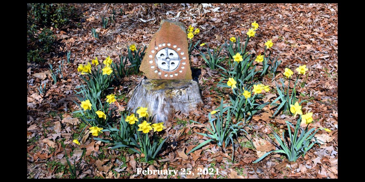
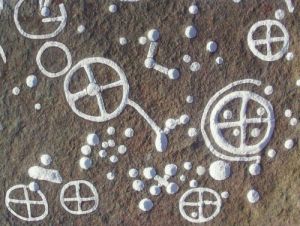
Photo Above: This same ancient symbol can be found carved on stone in Sweden, the State of Georgia, the State of Arizona and in southern Mesoamerica. Swedish daffodils will even bloom, when the ground is covered in snow. I obtained the bulbs from Amazon.com.
Chattahoochee is an Itza Maya word, which means, “Engraved Stone – Shallow River.” It means the same in Eastern Creek.
During the autumn of 2012, all six active members of the Georgia Council of Professional Archaeologists, plus the Public Relations & Archaeological Staffs of the Southeast Regional Office of the US Forest Service thought they had crafted a document, which would be the coup de grâce for a forthcoming History Channel program on the origins of the Creek Indians in the Southeastern United States. To be honest, though, I had manipulated them into thinking that the TV program was just about Track Rock Gap in the Chattahoochee National Forest. The article, which was distributed to several national publications, stressed that these Georgia archaeologists were the experts on the subject (<NOT!>) . . . that there was no evidence of visits to Georgia by Mesoamericans . . . and that I was not qualified to talk on the subject.
The article stated that no Maya writing had ever been found in Georgia. That is not true. Several Maya glyphs can be found in the art of Etowah Mounds, GA or petroglyphs in northern Georgia. Nevertheless, the refugees, who came to Georgia were obviously commoners, escaping a collapsing civilization. About 95% of the Mayas were illiterate, plus the Itza and Chontal Mayas did not utilize the Classic Maya writing system anyway.
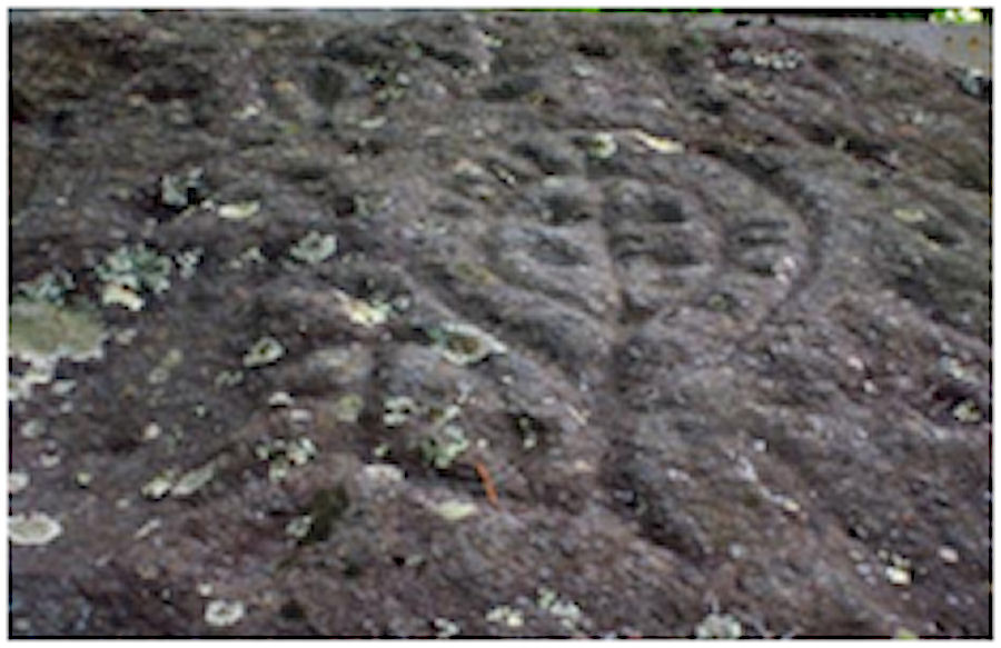
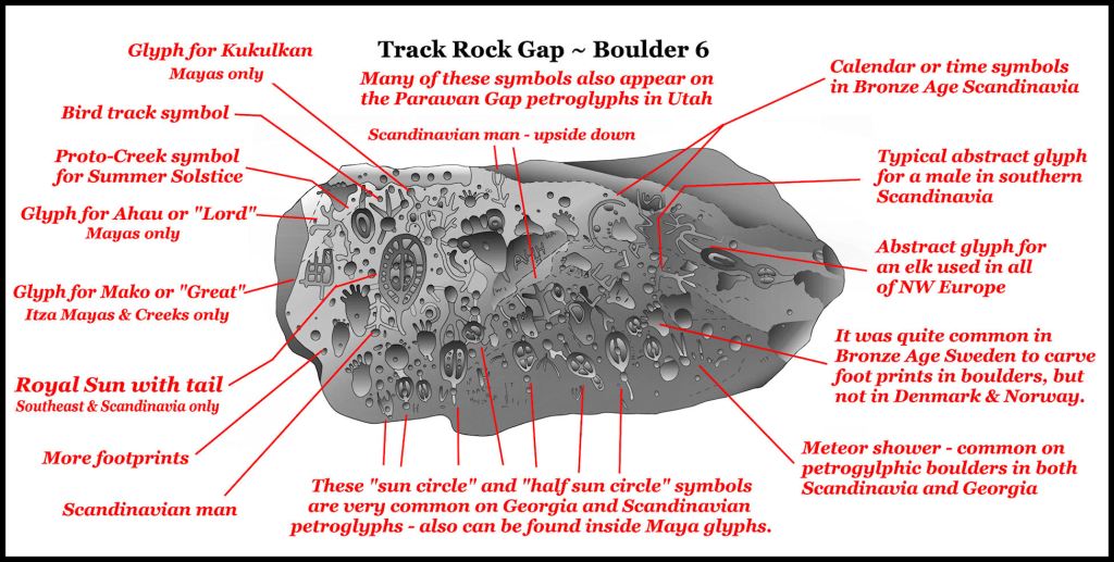
As the cover art for their nationally distributed article, which according to the limited knowledge base of the authors, proved no contact with Mesoamerica, they incredulously chose a Maya glyph on Boulder Six at the Track Rock Gap petroglyphs. It was the symbol that meant Henemako or “Great Sun” . . . the official title of a high king among the Mayas and the Creeks. It was the first glyph ever translated by anthropologist and Maya language expert, David Stuart. It was also the logo for the famous National Geo documentary film, “Cracking the Maya Code.”


Much more to this symbol than meets the eye!
Let me back up a bit. The Track Rock Archaeological Zone covers over a half square mile and is one of the most spectacular archaeological sites in the United States. I wrote the article about the Track Rock Terrace Complex in the National Examiner to help the local economy of Union County, GA and to provide jobs for archeologists. At the time, I assumed that the economy would soon improve and that I would restart my architecture practice within months. I never dreamed that here in 2021, I would be writing an article about Mesoamerican culture to an international audience.
The Great Recession had devastated both Union County and the archaeology profession. Eighty-five percent of anthropologists with post-graduate degrees in the United States were unemployed! I envisioned a massive WPA type project at Track Rock Gap to bring in jobs and tourists. Things have only gotten worse for archaeologists during the Trump Administration. Outside of a few successful multi-office consulting firms, headquartered in Metro Atlanta, the profession barely exists in Georgia today.
Back in 2012, I said very little about the Track Rock Petroglyphs, because I assumed that it was impossible to either translate them or precisely estimate their age. In truth, I had not really looked at them closely. I certainly did not “buy” the explanation by the Georgia Council of Professional Archaeologists that they were “graffiti by bored Cherokee hunters.” The Cherokees were no where around until after the American Revolution. However, I had no other explanation for them . . . then.
The Swedish Bronze Age connection
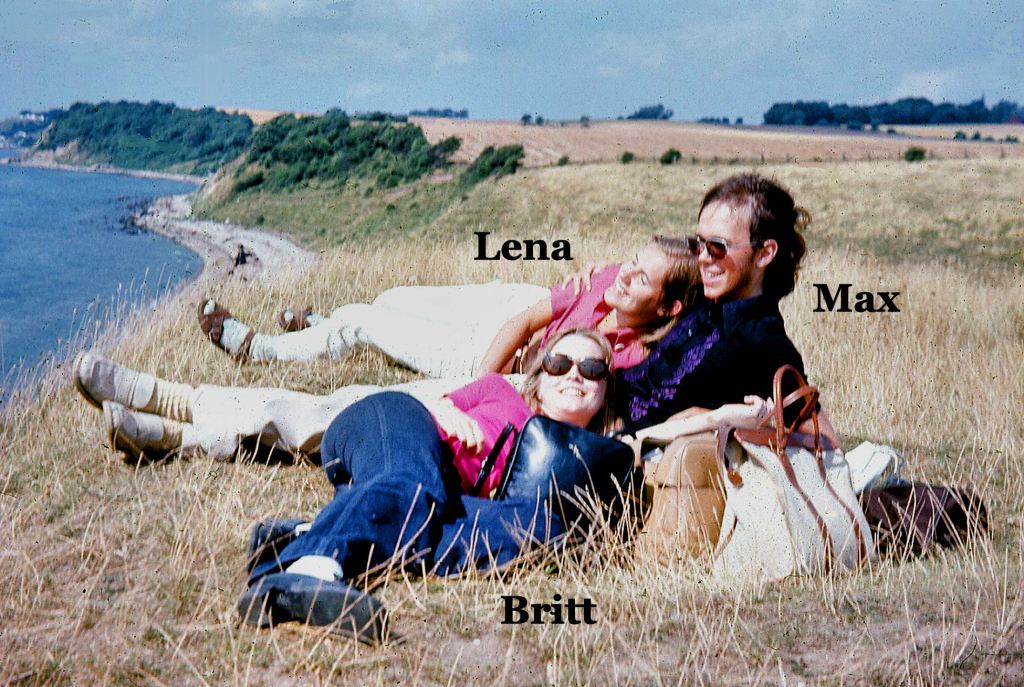
In the process of moving to my current residence in May 2018, I stumbled upon many boxes containing the memories of my life. Most had not been opened in decades. Having being forced to live an impoverished, monastic life during the Great Recession that stretched on for ten years, it was a great morale booster to find the boxes containing photos and love letters from the beautiful, intelligent women I had loved in the past. Eventually, in 2020, I was able to reconnect on Linkedin with Britt in Sweden and Vivi in France! Guess I should have expected it, but Britt has served in the Swedish Riksdag (Parliament) for many years and Vivi . . . you know about her from our Americas Revealed series, “The French Courtesan.” Alicia (Mexico City) and Yvette (while in Oaxaca, Mexico) are still missing.
There was something else, though, thousands of color slides. Among them were the petroglyphs of Sweden! I worked in Sweden, immediately after graduation from architecture school.
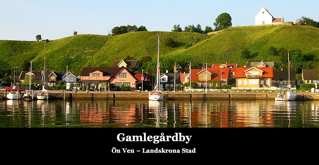
On my third day at the job, working for the Stadsarkitektkontoret (City Architect’s Office) in Landskrona, Sweden, my boss, Gunner Lydh, took me by boat to my project site, Ven Island. He intentionally showed me Bronze Age petroglyphs near the site to stress how important this location was to Sweden’s national heritage. I immediately noticed that most of the glyphs were Creek and Uchee Indian sacred symbols. I told Gunner that. He laughed in disbelief . . . but they are! I looked at my slides again. They symbols are identical to those at Proto-Creek town sites.
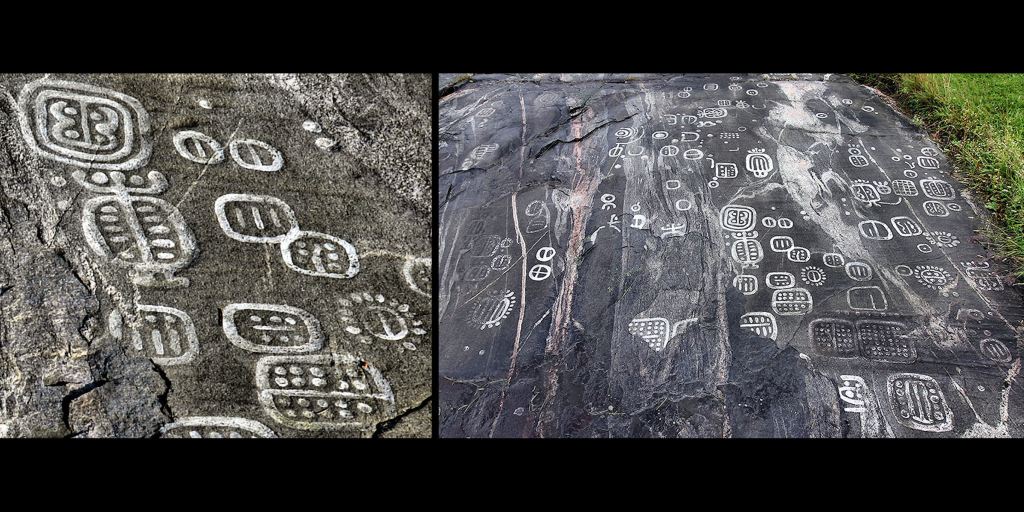
Those same Swedish Bronze Age symbols all appear on petroglyphic boulders in the mountains of Northeast Georgia. All but two of the symbols on the six Track Rock petroglyphic boulders also can be found among the Nyköping, Sweden petroglyphs, which have been dated to around 2000 BC. Some of the Nyköping symbols appear on other Georgia petroglyph sites, such as the Westmoreland Petroglyphs near my home. More common in North Georgia, though, are the Scandinavian and Irish Bronze Age symbols typical of the period from around 1800 BC to 500 BC.
However, here is the clincher. Several of the Nyköping symbols became the earliest known glyphs of a Maya writing system, carved in stone, around 300 BC. They may have been around earlier as symbols painted on bark or animal skins. Whatever the case, the symbols on the Track Rock Petroglyphs are the same, but probably predate the symbols, carved on stone, in Mesoamerica. The symbol that you see on the stone slab surrounded by daffodils meant “high king” in Bronze Age Sweden, Creek Indian culture and the Maya writing system. How could that be?
One possible explanation is the Maya Migration Legend. It begins is a cold land, where snow and ice covered the landscape during long winters. The Mayas ancestors were frequently persecuted by giants. They migrated southward along the edge of the Atlantic Ocean and North America then paddled southward till they reached a land where there was no snow . . . Yucatan. Of course, the modern Germanic Swedes also have a tradition that “Ice Giants” formerly inhabited Scandinavia. Could it be that the Nyköping Petroglyphs were carved by ancestors of the Mayas and that the Track Rock Petroglyphs were carved by the ancestors of the Mayas as they were migrating southward through North America. It is an interesting question, but I am not sure how this theory could be proven.
The Truth is out there somewhere!

Amazing!!
LikeLiked by 1 person
Howdy, E xcellent article, well done, concise. My own experience (no swedish blondes) has been comparing Texas rock art to Maya/Aztec.
On Sat, Feb 27, 2021 at 11:58 AM The Americas Revealed wrote:
> alekmountain posted: ” by Richard L. Thornton, Architect & City Planner > Photo Above: This same ancient symbol can be found carved on stone in > Sweden, the State of Georgia and in southern Mesoamerica. These Swedish > daffodils will even bloom, when the ground is covered i” >
LikeLiked by 2 people
Extremely interesting post Richard and I wish I could read the Petroglyphs.
LikeLiked by 1 person
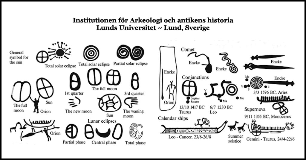
I can now translate most of the individual symbols on the Georgia petroglyphs, thanks to the professor at Lund University. However, I suspect that when combined together on a boulder or rock face they have a greater meaning, like letters in a word or words in sentence.
LikeLiked by 2 people
I would be in my element if I lived in those area’s where Petroglyphs have been found and would most likely want to study them. Thanks for your reply Richard.
LikeLike
This is starting to come together. We know (and can prove) that Earths magnetic poles shift or flip at certain clock cycles. Large or significant flips take place every 12 to 14 thousand years. And so it is with the Sun which Nova on similar if not exactly same time periods. (Probably integrated physics at hand) When these solar events take place the earth goes through geological disasters. Mini Ice ages, Ice Ages, rotation of earth stopping, great floods due to ocean momentum. Ancient humans knew of this cyclical disasters and recorded in permanent record of rock as such. My guess is their primary virtue and value to life was being good astronomers. Evidence suggest they knew when to get out of the North and head to the equator. They left information written in stone at locations they knew would not flood. Hence we find evidence in the mountains of the SE. Note top soil, rock, and landscape in the Appalachians is nearly oldest on earth. Would like to post a GE earth pic of the southern Appalachians. You can clearly see the massive flood etchings surrounding the mountains. My guess is they built structures and living quarters that acted as observatories and early warning systems to impending disaster. Should the constellations and sun not line up they knew the earth poles and solar clock cycle was moving. Much of the science portion of what I learned about the solar system and magnetic excursions is from https://www.suspicious0bservers.org/ Also daily news reports of current events of space weather gained here: https://spaceweathernews.com/
It is intriguing to bring these two branches of science together. Thank you Richard for bringing clarity to our human experience.
Charlie Harner
LikeLiked by 1 person