by Richard L. Thornton, Architect & City Planner
The short answer is that Appalachian is the Anglicization of the plural form of the name that the Creek Indians called themselves until the early 1750s . . . in English phonetics, Aparashi. The word is Panoan from Peru. It translates, “From the ocean (or the Upper Amazon Basin, if actually Pará) – descendants of.” The Creeks AND the Panoans of Peru rolled their R’s so hard that the European colonists recorded their R’s as L’s. That’s right, immigrants from Peru arrived in eastern North America about 800 years before the Itza Mayas of Mesoamerica.
Yet, today, all of the published explanations and etymologies for Appalachian are wrong, except for my recently published, Native American Encyclopedia of Georgia. Below is one from Wikipedia. Yet . . . there are books, published as late as 1884 by the Smithsonian Institute ethnologist Albert S, Gatchet, which correctly stated that the ancestors of the Creeks once occupied all of the Southern Appalachians and gave their original name to the mountains. The explanation of the evolution from an ethnic name to a major region of the United States is not so simple. For starters, here is the Wikipedia version:
“From a Native American village near present-day Tallahassee, Florida transcribed in Spanish as Apalachen [a.paˈla.tʃɛn]. The name was eventually used also for the tribe and region spreading well inland to the north. Now spelled “Appalachian”, it is the fourth oldest surviving European-given place-name in the US after Florida, the Dry Tortugas and Cape Canaveral. After the de Soto expedition in 1540, Spanish cartographers began to apply the name of the tribe to the mountains themselves.”

“Creek” Migration Legend – On June 7, 1735, The Migration Legend of the Kaushete People was presented to Supervising Trustee James Edward Oglethorpe and the leaders of the new Province of Georgia by Chikili, Paracusate (High King) of the Creek Confederacy in the form of a bison calf velum, painted in the Apalache writing system read by Chikili and its translation by Princess Kusapawnakesa. She was later known as Mary Musgrove.
In the next to last section of the saga, the Kaushete attacked a large town on the side of a mountain near Georgia’s tallest mountain. The Kaushete called the mountain Motele. The word survives as the name of the Nottely River. The high mountain is now called Brasstown Bald. This event probably occurred around 1500 AD, because it is the newest radiocarbon date for the Track Rock Terrace Complex.
The people of the high mountains lived in stone buildings, flattened their foreheads and spoke a language, which the Kaushete could not understand. They were hostile to the newcomers.
Immediately to the south in the lower mountains lived the Apalache. Their nobility also lived in round stone houses on the sides of mountains and the tops of hills, but their commoners lived in rectangular houses in the river valleys, built of timber and clay. The Apalache commoners like to build their towns next to waterfalls and river rapids.
The Apalache gave the starving Kaushete food and offered them friendship, if the Kaushete gave up their warlike ways. The Kaushete agreed and from then on built their towns across the river from Apalache Commoners. The two peoples promised eternal friendship and became the core of the Creek Confederacy two centuries later.
Panfilo De Narvaez – Panfilo De Narvaez had been appointed by the Governor of Cuba to lead the invasion of Mexico, but instead was arrested by Hernan Cortez. Most of his 900 Spanish soldiers and 1000 Taino warriors, plus many women, who accompanied them, were captured by the Aztecs and sacrificed. Their heads were mounted on racks.
As compensation for De Narvaez’s mistreatment, King Carlos named him Governor of Florida. All he had to do was conquer what is now the Southeastern United States to become a very wealthy man. He sailed from Spain with five vessels and six hundred men, but when he reached the West Indies, nearly a fourth of his men refused to go any farther. Then two of the vessels with seventy men on board were lost in a hurricane. On account of these misfortunes, he could not go on with his voyage until he could get more vessels and more men. In next spring he again set sail from Havana de Cuba, and on April 15, 1528, he entered a bay just north of what is now Tampa Bay.
A few days after landing, De Narvaez began his march to the north. He met some Indians wearing gold ornaments. He asked where the gold came from, and the Indians pointed to the north, saying “Apalache!” They made signs pointing to the north and indicated that Apalache temples were made of gold. The Spaniards assumed that a great deal of gold was to be found. The Indians meant the gold region of northern Georgia, which was the land of the Kingdom of Apalache, but the Spaniards thought they meant a much nearer province of Natives, somewhat more advanced than those in Tampa Bay, who occupied much of the Florida Panhandle. De Narvaez directed his Conquistadors to head north.
He had not looked for any great resistance from the natives, but, like Ponce de Leon, he soon found that they were very different from the gentler natives of the West Indies. Some were on the shore when he landed and, though they did not attack him, they made signs that he must go back to his boats and sail away.
De Narvaez decided that he would march with the greater number of his men along the coast until he should reach the large bay Miruelo had discovered, and there the ships with one hundred men on board were to meet him. But De Narvaez and the men with him never saw the ships again. The ships reached the bay, anchored, and waited in vain for the leader and his forces. Then, after cruising and searching along the coast for a year, they sailed to Mexico.
At the end of a long, hard march northward, the conquistadors only encountered relatively small villages with no gold or splendor of any kind. The women wore skirts made of Spanish moss.
De Narvaez made his headquarters at the capital town, which was called Anihaica, which means “Elite – Place of” in the Southern Arawak language of Peru. It was situated at the present location of Tallahassee. His expedition remained there several weeks. Throughout this period, the Natives tried to get rid of him. First, a kind of guerilla war was attempted against the invaders then the Natives tried the more successful plan of saying that their land was poor and not worth having. They told De Narvaez that nine days’ journey southwestward to the sea was a town called Aute, where plenty of provisions could be gotten. Since no gold could be found and provisions were in short supply, De Narvaez decided to go to Aute. Here was another disappointment. Aute was reached only to find that its occupants had burned the village and fled.
Hernando de Soto Expedition – In May 1539, de Soto landed nine ships with over 620 men, 220 horses and about 30 pigs in an area generally identified as south of Tampa Bay near present day Bradenton. The herd of pigs would eventually grow to over 300, but also leave many stragglers in a broad swath of the Southeast. The expedition initially zig-zagged through the central portion of northern Florida, but eventually turned west until it stumbled upon the village of Apalachen. Since this word was very similar to Apalache, De Soto incorrectly assumed that he was in the territory of the Apalache People, who supposedly had much gold. He found no gold.
De Soto’s men spent the winter in Anihaica. In late February 1540, De Soto’s men asked some leaders where they might find gold. They were told that the town of Yupaha in the mountains, two weeks march to the north. A two weeks journey at 12 to 15 miles a day (168-210 miles) would not have placed the conquistadors in the Georgia Mountains, but rather in West-Central Georgia . . . where there are gold deposits, but no large mountains.
Instead of heading due north as instructed, the Conquistadors veered north-northeast and eventually ended up two weeks later on the lower Ocmulgee River, where there is no gold. Yupaha was never mentioned again in the chronicles of the De Soto Expedition. They followed the Ocmulgee upstream until they reached Ichesi (Itza-si ~ Descendants of the Itza) and then veered northeast to the lower Oconee River, where they camped for a awhile at Okvte. Here they were convinced to head east-southeast toward the rising sun until they reached Kofitacheki. Neither Apalache nor Yupaha was named on the map published in 1544, which described the De Soto Expedition.
Tristan de Luna Expedition – In 1559, Tristan de Luna was awarded the right to establish a colony in what is now Pensacola Bay, Florida. They found region around Pensacola Bay virtually uninhabited. This was probably due to multiple waves of plagues due to European diseases during the previous 50 years. Before they could unload the vessels, on the night of September 19, 1559, a hurricane swept through and destroyed most of the ships and cargo.
After the loss of most of the colony’s supplies, most of the men traveled inland to the Alabama River. to the village of Nanipacana, which they had found abandoned; they named the town Santa Cruz de Nanipacana and settled in until the rest of the colony arrived. After most of the remaining supplies ran out, an expedition led by Major Matio de Sauz of 100 infantrymen and 40 cavalrymen was dispatched northward up the Alabama and then the Coosa River to obtain food from the powerful province of Kusa, which supposedly still prospered. A late 20th century book on the De Luna Expedition by a purple gate keeper of Southeastern archaeology incorrectly label de Saux a Sergeant Major. Now all references give him that low rank.
The Spaniards were garrisoned in a village of about 30 houses and were told that it was the town of Kaushe. Some of the men were survivors of the De Soto Expedition. They remembered being in a great capital, surrounded by mountains with over 3,000 houses. The expedition’s journal states that these men thought they had been bewitched into remembering this small village as a large town.
They were not bewitched. The physical description of this village of Kaushe matches the original location where the Kaushe people settled in northwest Georgia . . . at the confluence of the Conasauga and Coosawattee Rivers. Anthropology professors at the University of Georgia, who wrote about the De Luna Expedition were not familiar with the geography of Northwest Georgia and so did not catch the deception of the Kaushe leaders. They therefore assumed that the population of Northwest Georgia had dropped by 90% in 20 years.
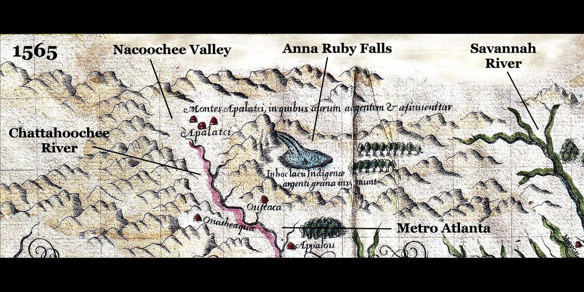
The 1562 Gutierrez Map – That was the official story. There is something suspicious about the official description of events between 1559 and 1561. In 1562, the official cartographer for the King of Spain, Diego de Gutierrez, published a map that contained new information gleaned from the Tristan de Luna Expedition. Note how the map ends the Alabama River roughly where Wetumpka, Alabama is now located . . . in Southwest Alabama. On the other hand, we suddenly see a rather accurate map of the Chattahoochee River, flowing down from the Georgia Mountains to the Gulf of Mexico. According to official Spanish records, no Spaniards had ever seen the Chattahoochee River in 1562 . . . yet there it is. The map does not even show the Coosa River. YET, this is the first map to correct show Apalachen to be in the Southern Appalachian Mountains. There is no mention of either Apalache or Apalachen in present day Florida.
Guess what? Apalachen is merely the plural of Apalache in the Apalache language of North Georgia.
North Georgia? Everybody knows that the Apalachee lived in the Florida Panhandle. It’s in all the encyclopedias, history and archaeology books. Don’t you think everyone would know, if it wasn’t so. Why did you say North Georgia?
1566 ~ Geronimo Chavez Map – This map by the Royal Geographer of Spain does not mention the Apalache, but interestingly enough, places the location of Fort Caroline and its successor, Fort San Mateo on the south side of the Altamaha River in present day Georgia.
1564-1565 ~ Fort Caroline – The current location of Fort Caroline National Memorial is totally bogus. No evidence of either a French or Spanish fort has ever been found on the St. Johns River. In fact, the St. Johns River could not even be accessed by sea-going vessels until immediately before the Civil War, when the US Army Corps of Engineers dredged a channel at its mouth.
Captain René de Laudonnière, Commander of Fort Caroline, dispatched six small exploration parties, which traveled through all of Georgia and much of the northeastern corner of Florida. Lt. La Roche Ferrière led a small party northward to the mountains, which was gone for over six months. He spent an extensive period of time with the Apalache People in Northeast Georgia. The Apalache towns were concentrated along the rivers flowing out of the mountains. Their capital was located on a major tributary of the May River, which joined with other Highland rivers then flowed southeastward to the Atlantic Ocean.
The Apalache had grown wealthy because of their control of the gold, copper and greenstone deposits in the mountains around them. Their Paracusate or High King offered to make an alliance with France.
Captain de Laudonnière was so enthusiastic about the information brought back by Lt. Ferrière that he planned to build the capital of New France on a plateau overlooking one of the May River’s tributaries. The location was two day’s march from the gold deposits. That location is now the University of Georgia. As soon as a thousand new colonists arrived by ship, Captain de Laudonnière would lead a large party up the May River and establish the capital.
Unfortunately, a hurricane struck the large fleet carrying the colonists off the coast of Georgia and a Spanish army under the command of Pedro Menendez massacred both the survivors of the storm and the occupants of Fort Caroline. The path of history was radically changed. Because the Spanish treated Native Americans with extreme arrogance, they would never be able to establish a permanent presence within the interior of southeastern North America.
At least 10 residents of Fort Caroline escaped execution by the Spanish because they were away from the fort on trading missions when it was attacked. The Spanish put a bounty on their heads. Six managed to reach the capital of Apalache, where they were given asylum by the King of Apalache, if they agreed to marry Apalachete wives.
- 1580 Dutch map – This map correctly places the Apalache in the mountains of present day northern Georgia. Chicora is shown to be at the mouth of the Savannah River. The map also shows the new European colony of Mellilot in northeastern Georgia.
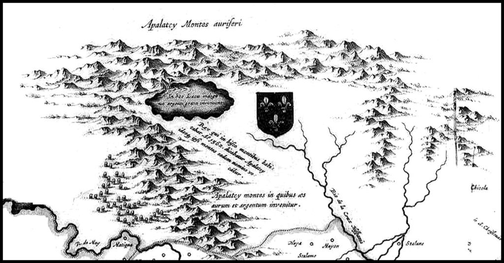
- 1590 Teodor de Bry Map – This map is based on an earlier water colored map by a member of the Fort Caroline garrison, Jacques Le Moyne. It. places the Apalache (Apalatcy) in northeast Georgia and names the mountains around them the Apalatcy Mountains.
- Maps 1600– 1694 – All French, English and Dutch maps in the 17th century showed the Apalache living in Northeast Georgia and did not use that name for the indigenous peoples of northwestern Florida.
- 1621 – English colonists settled in northeast Georgia within the Kingdom of Apalache. They were allowed to build an Anglican church . . . probably in the Nacoochee Valley.
- 1653 – Richard Brigstock – In 1653, a fleet of the Commonwealth of England blockaded the island of Barbados because it was known to be a center of royalist sentiment. A member of a prominent family on the island, Richard Brigstock sailed to the coast of Georgia then was a guest of the King of Apalache for almost a year. At that time, the Kingdom of Apalache stretched from southwestern Virginia to Southwestern Georgia.
- In 1658, French Natural Scientist, Charles de Rochefort, converted the notes that Brigstock took on the Native Peoples and natural environment of Georgia into ten chapters within his book, l’Histoire Naturelle et Morale des isles Antilles de l’Amérique. De Rochefort correctly stated that the Apalachete (Creek Indians) of Georgia were descended from the civilizations of Mexico and Peru and built many stone structures. He correctly stated that the Apalachete (Creeks) at that time only built their towns next to waterfalls and river shoals, at the Fall Line or northward. He also correctly stated that the Florida Apalachee never called themselves by that name until the Spanish called them that name. His book was extremely popular in Europe and went through six publications in multiple languages. It is still used as a classroom text in Europe so there is absolutely no excuse for North American academicians
- 1693 – David Morden map of North America – This was the last map to show the Spanish-speaking mining village of Apalache in the Nacoochee Valley.
- Spanish Map of 1697 – This map still showed the Apalache living in northern Georgia, but labeled one of the rivers in the Florida Panhandle, the Rio Apalache. A section of this map is at the top of the article.
- 1701 – Guillaume De L’Isle Map of Louisiana and Florida – This was the first published map to show the Apalachee in the Florida Panhandle and the Apalache in North Georgia. The Florida Apalache would soon be decimated by an invasion sponsored by Carolina.
- 1717 – Guillaume De L’Isle Map of Louisiana – The Apalache were only placed in the Florida Panhandle. The Muskogean Apalache People in present day northern Georgia are labeled the Conchakee or Apalachicola.
Maps in the 1700s
After 1717, most maps did not give a name for the mountain ranges in the Southern Highlands. Maps sponsored by Georgia showed northern Georgia as part of the Colony of Georgia. Most other maps until around 1790 showed northern Georgia to be part of South Carolina. In 1754, English cartographer, Emmanuel Bowen, was the first to name the mountains in Georgia, Apalachian Mountains. Up until then they were named the Apalache or Apalachen Mountains. In other words, the current name began as a misspelling of the indigenous name for the region.
- The mountains of present-day North Carolina, Tennessee and Virginia, north of the Hiwassee River were named the Cherokee Mountains until after the Cherokees were defeated during the French and Indian War.
- The Unaka and Cohutta Mountains were generally labeled the Enemy Mountains until after 1763, because they were in the territory of the Creek Confederacy, enemies of the Cherokees.
- Buell’s 1784 map of the United States named the entire Southern Highlands, the Allegheny Mountains. It showed the northern halves of Georgia, Alabama and Mississippi to be in South Carolina. The present- day Georgia-North Carolina Line was the approximate southern boundary of the Cherokees from 1733 to 1784.
- In his manuscript handwritten in 1826, “The History of the Cherokee People,” Cherokee Chief Charles Hicks stated that the Cherokees never lived south or west of the Hiwassee River until the latter part of the American Revolution, when the Chickamauga Hostiles fled westward and southward to hide from the militia units, based in North Carolina, Virginia and present-day Tennessee. Hicks called the Georgia Mountains, the Creek or Muskogee Mountains.
- By the time of the American Civil War, all of the mountains from Virginia southward were as a whole labeled the Appalachian Mountains. North of Virginia, cartographers generally labeled that region, the Allegheny Mountains. The term, “Blue Ridge Mountains” generally was applied only to a single mountain of that name, which ran from Virginia, through West Virginia, Maryland and Pennsylvania to southwestern New York.
Benton MacKaye was an American forester, planner and conservationist. He was born in Stamford, Connecticut; his father was actor and dramatist Steele MacKaye. After studying forestry at Harvard University, Benton later taught there for several years. I n 1921, MacKaye wrote his original plan—called “An Appalachian Trail, A Project in Regional Planning” . . .shortly after the death of his wife. This report formerly names all of the mountains in the Eastern United States, the Appalachians.
MacKaye’s idea detailed a grand trail that would connect a series of farms and wilderness work/study camps for city-dwellers along the Appalachian Mountains from the highest point in the North (Mt. Washington in New Hampshire) to the highest in the South (Mt. Mitchell in North Carolina). Hiking was an incidental focus of his plan. By the end of the year, MacKaye modified the concept to be a trail from Mount Oglethorpe . . . at the southern end of the Blue Ridge Mountains in Pickens County, GA . . . to Mount Katahdin, the highest mountain in Maine.
In 1922, at the suggestion of Major William A. Welch, director of the Palisades Interstate Park Commission, his idea was publicized by Raymond H. Torrey with a story in the New York Evening Post under a full-page banner headline reading “A Great Trail from Maine to Georgia!” From that point on, the general public and media began increasingly using the term “Appalachians” for all the mountains running from Alabama to Maine.
It was not until 1965, at the creation by Congress of the Appalachian Commission, that all of the mountains in the eastern United States became officially known as the Appalachian Mountains.

Homeless in the Appalachians
Throughout 2010, 2011 and early 2012, I was officially homeless . . . along with my three herd dogs, living in a tent, Olympic Games bomber’s hideout at Fontana Lake or in an abandoned chicken house near Track Rock Gap, GA. During the entire time, I was National Architecture columnist for the Examiner, but they did not know that fabric residence had to move to another point in the national forests every two weeks. During that interesting period, I wrote over three hundred articles for the Examiner and took several hundred photos. The best photos have been converted into a video with a sound track. It is presented below.
My article about the ruins at Track Rock Gap gained me the most notoriety, but the article, which I am most proud of radically changed the situation of homeless veterans. I camped for two weeks with a troop of homeless veterans in the Chattahoochee National Forest. The very personal articles, which I wrote resulted directly in radical policy changes by the Obama Administration, PLUS bipartisan support for the successful passing of the Prevention of Homeless Veterans Act. So, I guess more than one good thing came out of being evicted from my home on Christmas Eve.
I now live in the Habersham County end of Georgia’s beautiful Nacoochee Valley . . . a place where thousands of my ancestors once lived. Ironically, I bought a fixer-upper that had been seized by Fannie Mae. I traded up in the process. Now if I could only trade up to a female* soulmate, who likes to play indigenous American musical music (I have over 50 of them) . . . loves herd dogs and the mountains. * For the first two years I was here, local Trumpite gendarmes kindly spread the rumor that I was “gay male prostitute with AIDS, living on welfare.” LOL

It’s great learning pieces of history I thought I knew and realize there was more to what we were taught in school. Thank you for sharing this!
LikeLiked by 1 person
We are still learning! One discovery leads to another. Just think about those slides from Mexico that I am digitizing. There is so much I didn’t see in them back when I took the slides that now is obvious.
LikeLiked by 1 person
This is so interesting Richard. I am reading a book at the moment which includes how the Spanish treated the American Indians.
LikeLiked by 1 person
Richard, Here we all are in a open border country in the Atom age…and all these Evil people around you…GOD must be Testing You.
God’s Country:
https://www.bing.com/videos/search?q=god%27s+country&view=detail&mid=BF08E14DD52D2FD2CEB4BF08E14DD52D2FD2CEB4&FORM=VIRE0&ru=%2fsearch%3fq%3dgod%2527s%2bcountry%26form%3dANSPH1%26refig%3d4c38ede426e94f8ba325bde8afabf415%26pc%3dU531
LikeLike
Howdy, As always an education.
On Wed, Mar 31, 2021 at 5:02 PM The Americas Revealed wrote:
> alekmountain posted: ” by Richard L. Thornton, Architect & City Planner > The short answer is that Appalachian is the Anglicization of the plural > form of the name that the Creek Indians called themselves until the early > 1750s . . . in English phonetics, Aparashi. ” >
LikeLike