by Richard L. Thornton, Architect & City Planner
One Summer In Mexico ~ Part 60
The cylindrical astronomical towers at Chichen Itza, Mayapan and Itzate were virtually identical stone architecture. The two in Yucatan were ruins when the first Spanish conquistadors arrived in the region. To this day scholars speculate and debate the functions of these towers. However, there was another stone-walled, cylindrical observatory in the mountains of the State of Georgia, which is virtually unknown to North American archaeologists. We have a detailed eyewitness description of this observatory, by an English explorer, when it was in full operation. Yes, there are many facts left out of North American history books!


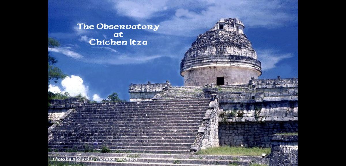
The Observatory or El Caracol (The Snail)
The Chichen Itza Observatory is dated to 906 AD by a stone stela on the Upper Platform. This date was in the Post Classic period of Mesoamerican chronology. This structure consists of a rectangular earthen platform, veneered with stone blocks and a cylindrical observatory about 35 feet (20.67m) in diameter at the base and 32 feet (9.75 m ) at the top. The smaller cylinder on the top, which no longer exists, was probably about 20 feet (6 m) in diameter. The highest point on the original tower was probably around 85 feet (26 m) above the plaza in front of the platform.
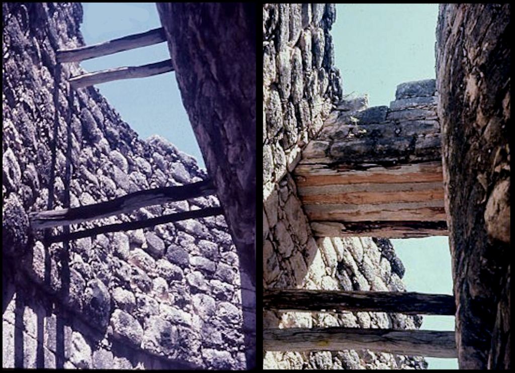
The observatory tower consists of concentric stone walls and three levels of an inner space, supported by Norman vaults. Archaeologists can only speculate on the activities that went on within the internal rooms. There are narrow openings in the walls to allow for precise sighting of the sun, moon, planets and stars. Visitors are no longer able to enter the observatory, but I was able to photograph radial wood timbers, which were used to mark time on a sun clock, plus calibrate special positions of the planets Venus and Mars in addition to some large stars.

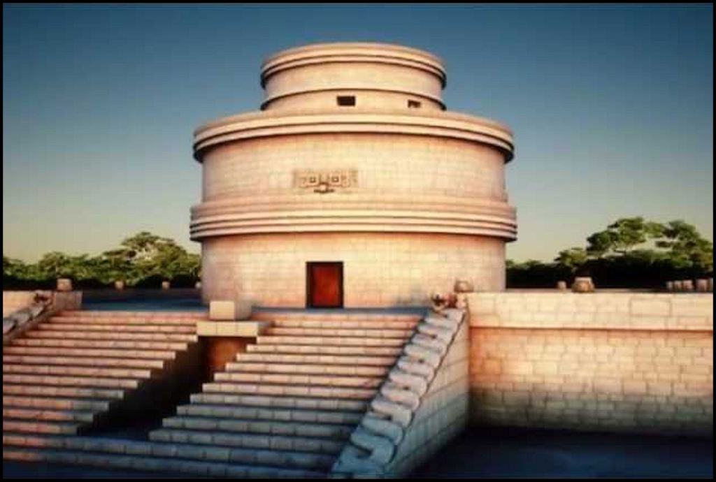
Mayapan Observatory
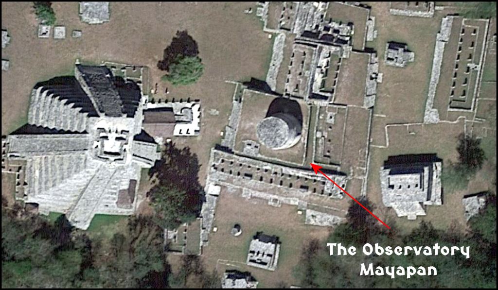
The observatory at Mayapan is in much better condition than the one at Chichen Itza. The tower is exactly the same size . . . 35 feet (10.7m) diameter at the base and 32 feet (9.75m) at the top. Note that it is identical also to the observatory at Itzate in the Nacoochee Valley of Georgia. Both observatories at Chichen Itza and Mayapan would have been completely unknown to the Dutch artist who engraved the observatory in Georgia.

The Nacoochee Valley Observatory
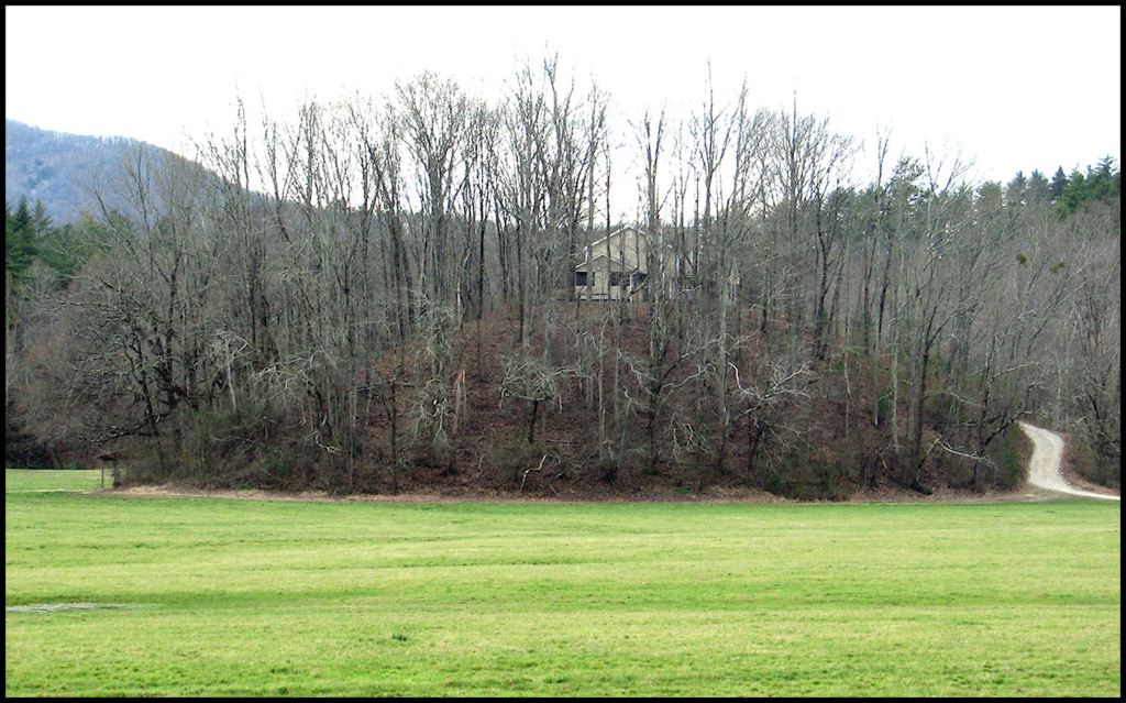
In contrast, the observatory on a large hill next to the Chattahoochee River in Georgia’s Nacoochee Valley was still in full operation, when visited by British explorer Richard Brigstock in 1653. Brigstock took detailed notes and made sketches, which he eventually passed on to the French Huguenot natural scientist, Charles de Rochefort. De Rochefort included the information within ten chapters about the advanced indigenous cultures of present-day Georgia in his extremely popular book L‘Histoire Naturelle et Morale des isles Antilles de l’Amérique. (Six editions published from 1658 to 1701.)
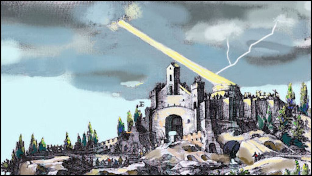
Richard Brigstock described the complex of buildings atop the large hill as consisting of an observatory, a temple and the home of the principal Joana (High Priest). In his June 6, 1735 speech to leaders of Savannah (now known as the Creek Migration Legend) High King Chikili did not use the title of his newly elected position, but introduced himself as “the Joana of the western towns.” The observatory consisted of two concentric stone walls, the outer being well over 30 feet in diameter. Within the tower were multiples levels for the most secret activities of the kitanen (priests who maintained the Sacred Fire and Day Keepers (astronomers). The Temple contained a large room with a large stone alter on which the elite would place their sacrifices (donations) of colorful clothing to be distributed to the commoners.
The temple also contained a large room where Painted Buntings nested during the warm months. Each autumn these birds would fly to Mexico to live with the Sun Goddess. The people of the Kingdom of Apalache would climb up to their hilltop and mountaintop temples in early autumn to give prayers to these birds, which they would pass on to the Sun Goddess, once arriving in Mexico. Commoners were not required to make any sacrifices.
Unfortunately, the observatory and temple complex in the Nacoochee Valley was dismantled by early 19th century white settlers to build stone foundations and chimneys. However, we do have verbal descriptions and a lithograph of it. In the late 1820s, the first use ever of highly destructive hydrological gold mining techniques washed away the artifact-rich sides of the Observatory Hill. About 50 feet (15.2 m) of the east slope, pictured below, was sheered off by the high pressure hoses, until the miners realized that the hill contained very little gold. Ironically, the official location where the first gold nuggets were found by white settlers that kicked off the Georgia Gold Rush was at the base of the hill, pictured in this mid-17th century engraving below.

The owners of the hill, where the temple complex once stood, have allowed me to study, photograph and film their property over the past three years. Of course, I am not disturbing anything underground. Archaeologist Robert Wauchope excavated several locations on and near the hill in 1939. I am relying on his findings, plus infrared and Lidar at this time. The stone retaining walls, shown in the engraving above are still visible in some locations. Detailed information on this archaeological site will be presented as a separate article and Youtube video.
In Part 61, readers will learn more about Itza Mayas and their cousins the “Real” Mayas, who were a mixture of Muskogean and Itza ancestry. Did you know that the real Mayas originally lived in southern Florida, but later colonized northern Yucatan?
You will also learn more about Chichen Itza and Mayapan. Most of the ethnic groups in southern Mexico and Central America, who the Spanish and contemporary anthropologists label Maya, never called themselves that name until the Spanish told them they were Mayas.

Interesting! From the research you have shared I see a lot of connections between Mexico and Georgia and think that’s why it has been left out of history books and ignored when the evidence is there. What I would like to better understand is who traveled where ? What drove these communities to leave their home and travel long distances? Many of these complexes where deserted when Europeans arrived in Mexico. Was it invasion by other indigenous groups that drove them out? I am also curious as to the indigenous people they first encountered in Mexico. If they weren’t Mayas where was their origin from? I have learned a bit from one side of my families puzzle but have not started with the South American part and their connection to the Yucatán other than their close proximity. Can’t wait to read party 61!
LikeLiked by 1 person
Thank you for explaining parts of history in depth and helping others as my self better understand it.
LikeLiked by 2 people
When that house was being built on the hill, it worried me because somehow I knew that was not just a hill. I knew it was an important site, but I never dreamed it could have been the site of an observatory. Wow!
LikeLiked by 1 person
It was more than that. Archaeologist Robert Wauchope proved that Roanoke Colony survivor, Eleanor Dare lived on top of that hill the last ten years of her life.
LikeLike
That’s fascinating!
LikeLike
Howdy, Great photos.
On Fri, Apr 9, 2021 at 6:57 AM The Americas Revealed wrote:
> alekmountain posted: ” by Richard L. Thornton, Architect & City Planner > One Summer In Mexico ~ Part 60 The cylindrical astronomical towers at > Chichen Itza, Mayapan and Itzate were virtually identical stone > architecture. The two in Yucatan were ruins when the first S” >
LikeLiked by 1 person
Richard, a crystal that could ignite fire? That sounds like a connection to Archimedes the Spartan or Greek who did the same to Roman ships. The term “Kita” seems to be a connection to the lower Cherokees / Creeks for the word Kita-wah or Kita-ra where their astronomers priest received their training. “Kita-ra” seems like a connection to that Georgia hill and the post- Maya peoples. Another Great article!
LikeLiked by 1 person
Kitani, Kitua, etc are all Muskogean words having to do with the ignition of a fire. The Cherokees and Cherokee scholars are really bad about not considering other languages before giving speculative meanings for words.
LikeLike
Richard, In my understanding the lower Cherokees could be related to the proto Creeks. Ani-Kituwah part of the Cherokee Nation seem to be relating themselves to that area of North Western Carolina (lower Cherokees). The term “Tani” can be connected to words all the way to the Black Sea area…for example: Bronze age Bri-tani people of England’s history. It’s likely the Bronze age Sea peoples have some word connections and built with stone. The Para-kusa spoke of a people that came from a “barren land” long ago: the Anasazi? They likely became Creeks and Cherokees.
LikeLike
Truly fascinating had no idea. Do you make any connection between such things and say things like The Georgia Guidestones or for that matter, Scottish Rite/Freemasons like Oglethorpe expressing such fascination with these areas and the Lower Creeks? “Advance knowledge” kinds of subjects? “Lost Tribes” so to say? We see one of the Georgia Trustees citing meridian line elements, “Savannah sits on the same latitude lines as distant Palestine.” All very Jacobite at certain levels as well. The original desire to import so many Jews here along with Freemasons for this kabalistic sort of Pre-Israel 300 years prior kind of thing? Oglethorpe in his letters drew comparisons between the Ancient Romans and The Creeks but think that was to illicit some obvious public intrigue and think more to it than that. That’s quite a lot to take in all at once but would love to see you address some ot those concepts and connections in a future article if so desired.
LikeLike
Like most people, I don’t know anything about who actually put up the Guidestones. However, I do know that a famous rabbi in Amsterdam, Holland during the 1600s, described the region that is now the State of Georgia as “the New Jerusalem” and said that a new temple was being built there. I think it was on Browns Mount near Macon, GA – since that would be the same latitude as Jerusalem. In a book, this rabbi urged Jews to move to New Jerusalem.
LikeLike