Includes a bonus feature! Learn how some University of Georgia anthropology professors fictionalized the history of Etowah Mounds in 1995. It was to help their covert client place a Cherokee gambling casino near Etowah Mounds. Fortunately, this scheme didn’t happen, but visitors to the Etowah Mounds museum are now presented fake history!
by Richard L. Thornton, Architect and City Planner
One Summer In Mexico ~ Part 66
“The Creek Indians are different than any Native people ever encountered by British colonies to the north of Georgia. They are obviously the descendants of a great civilization. Their intelligence is equal to or greater than Englishmen. They should be treated as equals in all endeavors. In doing so, both peoples will remain the fastest of friends and prosper together.”
Supervising Trustee James Edward Oglethorpe – letter to King George II (1734)
“The Creek Indians are a savage and vile race. They were so ignorant that they refused to acknowledge the natural superiority of White People and never submitted to our God-given authority. Georgia is blessed to be rid of them!”
Early History of the Methodist Church In Georgia (1911)
All good things come from the North!
Why did James Oglethorpe know something that today’s Gringo archaeologists don’t? Through the years, The America’s Revealed has presented to you a series of highly credible . . . initially, eye-witness authors, from the Early Colonial Period until Charles C. Jones in Savannah and Gates P. Thruston in Nashville, who described Native American peoples in the Southeast with advanced cultures and obvious ties to civilizations to the south. Why would otherwise well-educated people still today stick to myths and speculations made by writers, who came along later? The answers come not from different interpretations of scientific data, but deep-set racial and regional prejudices.
There is a distinct pattern. As early as 1574 (Captain Réne de Laudonnière) authors described Southeastern Indians as being culturally advanced humans, while authors in New England describe Indians as being dull-witted, sub-human savages, who should be swept from the landscape. Throughout the Late Colonial Period and early 1800s, New Englanders wrote a series of fictional novels and speculative treatises, which ascribed the construction of mounds and other artificial earthworks to either white Europeans or the Ten Lost Tribes of Israel.
In response, Thomas Jefferson excavated a mound near Montecello in 1780 to prove that its builders were American Indians. William Bartram, who published his book on the travels in the Southeast, intentionally ascribed the now abandoned earthworks as being built by the Creek, Choctaw and Chickasaw Indians.
In 1833, Jefferson’s friend, Samuel Kercheval, clearly credited the many mounds and Mesoamerican type artifacts in the Shenandoah Valley to Native American immigrants from Mexico or South America. (Early History of the Valley of Virginia). Current Virginia history textbooks and maps of Native American tribes now claim that the Valley was uninhabited hunting lands and that the Southeastern mound builders never lived in the western part of the Commonwealth.
In 1873, Savannah archaeologist, Charles C. Jones, Jr., ascribed the mounds in northern Georgia to ancestors of the Creek Indians, because they all contained artifacts, very similar to those in Macon and Columbus, GA. A decade later, James Mooney, a Smithsonian ethnologist from Indiana, automatically labeled these same mounds as “Cherokee” without even digging in them.
What we see, though, from the mid-1800s onward, though, is a concerted effort by Northern intelligentsia to force their prejudices toward Native Americans and general contempt for Southerners into the world of anthropology. One variation, we see at the late 19th century Smithsonian Institute is that the mounds are credited to Indians, but only to Cherokee Indians, since they were originally from the North. Being that the majority of textbooks were being printed in New England, the Northern viewpoint steadily became orthodoxy.

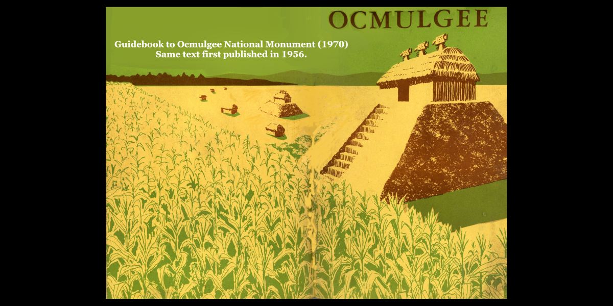
Once upon a time at Ocmulgee
This past weekend, I stumbled upon the 1970 official guidebook to Ocmulgee National Monument and my notes from a Georgia Tech class field trip to Macon. I had to take an introductory course in Southeastern Anthropology, taught by the famous archaeologist, Lewis Larson, prior to going to Mexico on the Barrett Fellowship. I was stunned how really ludicrous the official understanding of Ocmulgee was at that time. Now to be honest, more progressive archaeologists like Larsen were privately challenging SOME of these beliefs, but they were still official orthodoxy at the national level of his profession.
After reading this article, you will better understand how stunned I became at my first orientation meeting at the Museo Nacional de Antropologia with Dr. Román Piña Chán. He immediately asked me why the Indians at Etowah made marble statues of Maya slaves? He then pulled out his landmark book, La Cultura Madre, and showed me that the earthen “pyramids” of the Olmec Civilization were identical the earthen mounds of the Southeastern United States. He then pulled out his landmark book, Chichen Itza . . . the City of the Wise Men of the Water, and showed me how the art on the shell gorgets and copper plates of Etowah Mounds had the same human figures as found on the bas relief stone carvings at Chichen Itza. He then pulled out his landmark book, Los Toltecas, and showed me that several types of art and artifacts, excavated at Tula, the capital of the Toltecs, were identical to art and artifacts, excavated at Moundville, Alabama.
If you had visited the Ocmulgee National Monument Museum with our class in 1970, this is what you would have “learned:”
- Wandering Hunters from the Southwestern United States, making Clovis points, were the first humans to live on the Ocmulgee River. Actually, we now know that the oldest Clovis points in the Americas can be found along the Savannah River in South Carolina and Georgia.
- Early Hunters from the Ohio Valley introduced pottery to Georgia around 1000 BC. Actually, the oldest known pottery in North America has been found in eastern Georgia. It dates to about 2500 BC. Pottery did not reach Ohio until around 1000 BC.
- The Swift Creek Culture was founded Middle Georgia by Northern Indians, who formerly lived around Boston, Massachusetts. Actually, my first mentor, Dr. Arthur Kelly, proved in the early 1960s that Swift Creek pottery was introduced by an unknown tribe that immigrated into Georgia from somewhere south of Florida. Archaeologists, outside the Southeast ignored his report. Saying that Swift Creek came from the south was one of the controversial statements that got him forcibly “retired” in December 1969. In 2015, I identified that tribe to be a Panoan people from eastern Peru. Even today, Gringo archaeologists are blissfully unaware that the Conibo People of Peru still today use the exact same artistic motifs, found on Swift Creek pottery.
- Early Farmers from the Hopewell Culture in Ohio introduced sophisticated pottery, permanent villages, burial mounds and gardening to Middle Georgia around 500 AD. Actually, the oldest known permanent agricultural villages in North America were found on the Chattahoochee and Etowah Rivers in Georgia. They date to about 400 BC. The oldest known mound in all of the Americas, the Bilbo Mound, is found in Savanah, GA. It has been radio-carbon dated to 3545 BC!
- Master Farmers from Cahokia, Illinois introduced maize (Indian Corn) and the construction of large temple mounds to Middle Georgia around 900 AD. Actually, we now know that the first mound-building at Cahokia occurred around 1050 AD. Construction of the Great Temple Mound at Ocmulgee began around 900 AD, but some mounds near the Ocmulgee Acropolis are much older. For many centuries, there were large villages on both sides of the Ocmulgee River. Ocmulgee National Historical Park is the oldest known location where all elements of the “Mississippian Culture” can be found.
- About 200 years after Ocmulgee was abandoned, Farmers (proto-Creek Indians) settled the Lamar Village. Actually, in 1973, archaeologists employed by the National Park Service obtained radiocarbon dates for the bases of the two larger mounds in the Lamar Village. Construction began around 990 AD. About 4-5 years later, the same ethnic group founded Etowah in northwest Georgia.
The banishment of Charles de Rochefort
The J. Carter Brown Family owned one of the largest library collections on the Colonial Period in the United States. Included, were books by Richard Hakluyt, Peter Martyr, Réne de Laudonnière and Charles de Rochefort, which provided eyewitness accounts of advanced indigenous societies in the Lower Southeast, in particular, the Kingdom of Apalache in what is now northern Georgia. The 1658 book by Charles de Rochefort contains 10 chapters on the Native American inhabitants of what would become Georgia. Those chapters included astonishingly accurate details about Native American architecture, towns and mounds, which not be re-discovered by archaeologists until the late 20th century. He even explained how the defensive ditch and palisade walls at Etowah Mounds were constructed!
In 1846, this library was donated to Brown University. During the Civil War Era . . . operating under the obvious fact that since white Southerners were stupid, uncivilized and backward, so were the former Indians of that region . . . notes were placed in Early Colonial Period books, which warned readers not to believe anything written about the “Indian civilizations in the barbaric South.”
In 1904, the historical books in the J. Carter Brown Library were made accessible to scholars outside the university. Apparently, several “flagged” books were reviewed by a faculty committee. l’Histoire Naturelle et Morale des isles Antilles de l’Amérique by Charles de Rochefort was banished to the Fantasy and Utopia bin in the attic of the library. A note inserted in the book by a professor stated that although the book’s description of flora and fauna seem accurate, the inclusion of 10 chapters on an Indian civilization in Georgia are not credible. Therefore, the book should be considered fictional.
There the book sat, collecting dust, until discovered by Marilyn Rae in 2013. She was first attracted to the book, because it contained a page size engraving, which thought was the Track Rock Terrace Complex. I eventually figured out that it was the Sun Goddess Temple in the Nacoochee Valley.
Marilyn and I jointly translated the 10 chapters on Georgia then published an annotated translation as The Apalache Chronicles (Ancient Cypress Press). What astonished me most about the eyewitness accounts of North Georgia in 1652 was the profound influence of South American and Caribbean tribes on that region of the nation. Many traditions, like the Sacred Black Drink, turbans, Creek long shirts, Creek squares and the Stomp Dance were from Eastern Peru . . . not home grown. There were several key words in Muskogee, which are Panoan, and many Native American town names in Georgia which are from South American languages. Even the Appalachian Mountains get their name from words of Peruvian origin.
Those discoveries were a game-changer!
1939 De Soto Trail Commission
In 1939, President Roosevelt appointed the famous ethnologist, John R. Swanton, to lead a blue-ribbon commission of scholars, which was charged with determining the route of the Hernando de Soto Commission through the Southeast between 1539 and 1542. Swanton was considered the nation’s leading expert on American Indian languages. He was able to approximate where the conquistadors were by the ethnicity of the American Indian words, recorded in their chronicles.
The commission continued a tradition continued to this day by archaeologists in the Southeast in ignoring Colonial Period maps. Instead, Swanton headed the highly un-educated speculations of late 19th century Smithsonian anthropologists Cyrus Thomas and James Mooney that the Cherokees had arrived in North Carolina prior to the Columbus voyages. Actually, no map of the future Southeastern United States prior to 1715 even mentions the Cherokees.
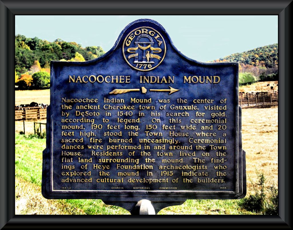
Swanton knew that there were no Cherokee words or village names in the De Soto Chronicles. At the time, archaeologist Robert Wauchope was working in northern Georgia. Swanton asked Wauchope to determine the ethnicity of the mounds at Tugaloo and in the Nacoochee Valley, since the commission thought that De Soto and later, Juan Pardo, came through these valleys.
Wauchope responded that the mounds at Tugaloo and Nacoochee only contained traditional Creek-style artifacts. At the end of 1939, he notified Swanton that he could find no Cherokee artifacts or villages in the Nacoochee Valley. Apparently, even during the period between 1785 and 1821, when the Nacoochee Valley was officially inside the Cherokee Nation, its occupants were actually mixed-blood Creeks. You won’t believe what the State of Georgia did 15 years later!
The 1947 American Indian conference at Harvard
It was in 1947 that radio-carbon dating was invented, but the equipment was not generally available until the mid-1950s. Nevertheless, archaeologists that year decided that they knew everything they needed to know to in order to create a comprehensive orthodoxy for the American Indians in North America. The conference was held at the oldest and most prestigious archaeology department in the nation – Harvard University near Boston. Until the 1960s, the majority of PhD archaeologists in the United States were Harvard graduates.
The conference adopted the following religious beliefs. All have been proven to be totally wrong:
- The first humans in the Americas were “Clovis People,” who crossed the Bering Land Bridge around 8000 BC and settled in the Southeastern United States. From there they spread northeastward, eastward and southward.
- The first pottery and burial mounds in the United States was created by the Adena People in Ohio.
- The first ceremonial mounds and agriculture in the United States were created by the Hopewell People in Ohio.
- Around 600 AD, the Hopewell People migrated westward to American Bottoms where the Mississippi, Ohio and Missouri River converge. There, they founded Cahokia, Illinois. Corn, bean and squash seed magically jumped from Central Mexico to Cahokia, It was in Cahokia where the Mississippian Ceremonial Mound Culture was invented around 900 AD. There was no direct contacts between the United States and Mexico.
- The conference determined that all burial mounds and village site in the Southeast must post-date those in Ohio, while all large towns with large ceremonial mounds must post-date the mounds in Cahokia.
Although all of these “facts” were eventually proved to be false, for decades they convoluted and retarded serious scientific research in the Southeast. Archaeological reports that conflicted with orthodoxy would not be published and the young professors, who submitted them would not get tenure. When reliable radiocarbon dates in the mid-1950s began to conflict orthodoxy, the archaeologists either concealed them to avoid losing their job or labeled them as being inaccurate because the dates conflicted with the arbitrary dates selected at the Harvard Conference.
State Hysterical Markers
Tennessee, Georgia and Alabama were the place to be during the 1930s, 1940s and 1950s, if you were an archaeologist. Federal and state agencies funded dozens of major archaeological excavations, supervised by many of the most famous American archaeologists of the late 20th century. Their presence elevated the anthropology programs at the Universities of Tennessee, Alabama and Georgia to national status. You would think that such prestige would have motivated these states to dot the landscape with accurate historical markers, which celebrated the discoveries of their archaeologists. Well, not in Tennessee and Georgia.
Tennessee chose to ignore its archaeologists and only erect markers that noted the locations of 18th century Cherokee villages. Non-Cherokee town sites are not marked. Tourist literature tells visitors that the occupants of towns with Creek names, visited by the De Soto and Pardo Expeditions, were actually Cherokees. Tennessee history textbooks do not mention that the Uchee, Chickasaw, Upper Creeks and Chiska were living in eastern Tennessee for many centuries before the Cherokees moved southward into the region. When Pre-Columbian skeletons were returned to the state by the TVA, state officials labeled them Cherokee and invited Cherokee officials to preside over the reburial ceremonies.

Tennessee history textbooks and historical markers do not mention an early 18th century French fort at the confluence of the Tennessee and Little Tennessee Rivers. Tourists and students are also not told that Upper Creeks, Uchees and Chickasaws occupied southeastern Tennessee until after the American Revolution.
During the 1950s and 1960s, the Georgia Historical Commission also chose to ignore its archaeological reports when erecting historic markers, but went a step further. State historical markers elevated obscure frontier fairy tales up to the credibility of official history status. Georgia’s actions, however, are far less excusable than Tennessee’s. Georgia has some of the most accurate 18th century and early 19th century maps in the Southeast. At the end of the Revolution, Georgia was bickering with North and South Carolina over their boundaries. In 1784, surveyors were sent in to accurately survey the state boundaries, major rivers and mountain ranges.
In the autumn of 1754, an army from the Creek town of Coweta defeated the entire Cherokee Nation, thus ending the 40 year long Creek-Cherokee War. All Cherokee villages south of the Snowbird Mountains in North Carolina were burned. Thirty-two Cherokee chiefs were executed. The Cherokees signed a surrender treaty on December 16,1754. The locations of the burned Cherokee villages are noted on the 1755 John Mitchell Map of North America. These well-documented facts are left out of Georgia’s, Tennessee’s and North Carolina’s official state history texts. Instead all three state history texts tell students that the Cherokees first occupied northern Georgia around 1450 AD.
The official 1785 state map labels all of North Georgia, except a county located north of the Tallulah River as “Upper Creeks of the Muskogee Creek Nation.” Nevertheless, in the mid-1950s Georgia erected markers, describing three different fairytale versions of how the Cherokees “captured” North Georgia. The one at Neels Gap says that the Cherokees won North Georgia at the battle of Blood Mountain in the early 1700s. There are two other versions in Ball Ground, GA. The one in its downtown states that the Cherokees won all of North Georgia in a game of stickball. Out from town, tourists are told that the Cherokees won all of North Georgia in 1755 during the fictional “Battle of Taliwa.” The sign says that the famous Cherokee warrior Kingfisher died in this battle. Another state historical marker in Rome, GA accurately tells readers that Kingfisher died in the Battle of Etowah Cliffs in 1793!
Tugaloo Island: In 1953, University of Georgia archaeologist, Arthur Kelly, excavated two mounds near the bank of the Tugaloo River, next to Tugaloo Island. The smaller mound turned out to be a Late Swift Creek burial mound, dating from around 500 AD. The larger mound was a Lamar Culture burial mound, whose initial construction Kelly dated from around 1450 AD. In his report, Kelly clearly stated that both mounds contained artifacts, typical of the ancestors of the Creek Indians. Throughout the 1700s, the Tugaloo and Tallulah Rivers were the southern boundary of the Cherokee tribal territory. However, official maps of the colony showed Uchee villages on north sides of these rivers, not Cherokee. Colonial Indian Agent, the Rev. Charles Wesley, visited Tugaloo Island in 1736. He reported that it was occupied by about 100 Uchees. He had intended to also introduce himself to some Cherokees, but could find none in Northeast Georgia.
In 1955, the Georgia Historical Commission erected a marker next to the island, which stated that the island was first settled around 500 AD and then permanently occupied around 1450 AD by the Cherokees. No mention was made of the Uchee.
In 1957, Smithsonian Institute archaeologist Joseph Caldwell led a team, which excavated all of Tugaloo Island. Caldwell confirmed Robert Wauchope’s 1939 statement that the mounds contained only Creek-style artifacts. He determined that the island was first settled around 1200 BC, probably by Uchees. Around 500 AD, people making Late Swift Creek style pottery settled there and began construction of its first modest burial mound. Larger mounds were begun by other ancestors of the Creeks from around 800 AD. The town thrived until c. 1700 AD. All artifacts in all layers of mounds were consistent with ancestors of the Creek Indians. A few years after the town was burned, another ethnic group erected crude round huts in one section of the plaza. This village was permanently abandoned around 1776.
In 1961, the Georgia Historical Commission erected a second historical marker near the Tugaloo River. It stated that the town on the island was founded by the Cherokees around 1450 AD and that this was the first Cherokee town in Georgia! It credited the Cherokees with building all the mounds and stated that Cherokee priests tended sacred fires 24/7 in each of the mound top temples. No mention was made of the Uchee or Creeks. In subsequent years the texts of these two fictional historical markers were incorporated into the official Georgia State History textbook.
Creating a fake history of Etowah Mounds
In early 1996, I moved to a spacious rental townhouse, adjacent to the Etowah Mounds Archaeological Zone. This was a happenstance decision since my divorce was about to be finalized and I anticipated having about $100,000 from my share of the farm in Virginia, to buy another farm in the Georgia Mountains. That amount was equal to about $250,000 today.
Initially, the Etowah Mounds Museum was closed for remodeling, but soon opened. I was in walking distance of the mounds and so went there often, not knowing that 25 years later, I would be devoting 100% of my work time in Native American research. I immediately noticed changes in the museum’s presentation. The excellent film about the excavation of the mound in the 1950s had been replaced by a film on the Cherokee People, hosted by the talented Cherokee actor, Wes Studi. Etowah Mounds was mentioned briefly, but the film stated that the mounds were occupied by both the Cherokees and the Creeks . . . in that order . . . inferring that the mound had been built by the Cherokees.
The central exhibit of the museum had been removed. It was a plastic skeleton, surrounded by grave goods, which reproduced the appearance of a royal burial, unearthed in Mound C. I asked the manager, who was a Creek lady from southwest Georgia. I told her that Georgia Creeks were very proud of this exhibit, since it was not an actual human skeleton. She said that actually, no one from Georgia complained about it. The state received a complaint from some North Carolina Cherokees and knuckled under. I told her that it was none of their business. She agreed, but that’s politics.
I also noticed that many of the more sophisticated copper and pottery artifacts had been removed. I asked the manager what had happened to them. She said that the University of Georgia professors had ordered them removed and then shipped to their offices. She didn’t know what happened to them after that.
The chronology of Etowah Mounds had been changed from when I was last there in 1970. The museum brochure and initial exhibits said that there only three occupations at the mounds before the Cherokees lived there. The site had never been occupied until newcomers arrived around 1000 AD. None of the statement was true. The Cherokees NEVER lived at Etowah Mounds, as stated by Wikipedia. They avoided the place, thinking it to be haunted.
A year later, I was working on the restoration of the Roselawn Mansion in Cartersville. That was the actual location of the Cherokee village. The cemetery of the Etowah Cherokee Mission was under the front lawn of Roselawn.
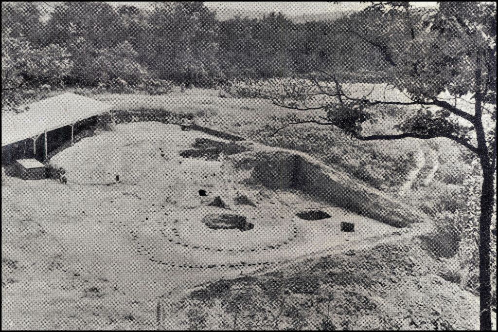
In 1886, the Smithsonian Institute excavated a Deptford Culture mound, dating from at least 800 BC, on the south side of the Etowah River, where the state does not own much land. Around 1200 AD, the Etowah River flooded and split the original town in half. In the big 1954-1957 excavation Dr. Arthur Kelly found later occupation levels associated with the Swift Creek Culture, Napier Culture and Woodstock Culture. Typical of most other town sites on the Etowah and Chattahoochee Rivers, this place had been occupied over and over again . . . and it had been occupied four times by the ancestors of the Creeks, not three. Dr. Kelly found a level of mixed Late Lamar (Creek) and European artifacts, which apparently lasted throughout the 17th and early 18th century. He ran out of money and time to excavate it separately, then never got around to the project afterward.
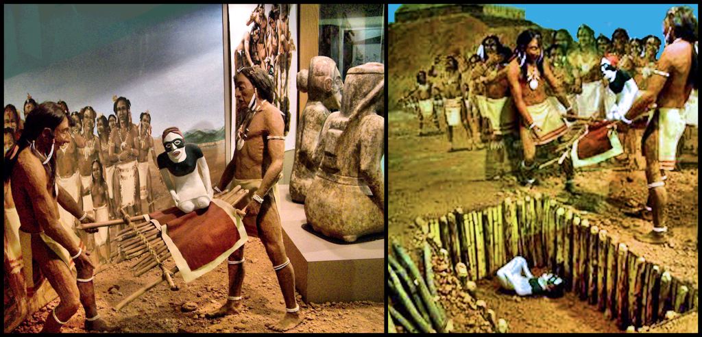
The big shocker was a diorama behind reproductions of the famous marble statues of Etowah. It stated that around 1585, Etowah was under attack, so the leaders ordered the burial of the statues in a shallow grave under the ramp of Mound C. In their panic to hide the statues before the town was captured, they dropped the statues, damaging one of them. The town was soon captured by an Indian tribe from the north, aka the Cherokees.
That was it! I was furious. I went back to the site manager and told her that I had worked for Arthur Kelly and had Lewis Larson as an anthropology professor. The two of them had given my Pre-Columbian Architecture class a tour of the site. The diorama was a total lie. The statues had been found by Lewis Larson in a collapsed log temple at the base of Mound C. There were human bones scattered all over the floor of this temple. One of the statues had been damaged, when a wooden table rotted and collapsed.
She responded that I was just a visitor to the museum. The Division of Parks and Historic Sites had to rely on the guidance of professional archaeologists. I went back to my townhouse and eventually found my old copy of the archaeological report for Etowah Mounds from 1970. I photocopied the report and gave it to the site manager. She was astounded when she saw the photographs of the statues being unearthed at the base of Mound C, not the surface of the ramp. She also quickly recognized the major conflicts between other new stories told by museum exhibits and what the archaeologists actually found. She forwarded a letter from me and the photocopy to her bosses. A couple of weeks later, she received a curt response from Dr. David Hally, Director of the Department of Anthropology.
“This man is not qualified discuss archaeology. His comments should be ignored.”
We later learned that some wealthy investors, led by a gentleman, who would be one of the largest donors to the 2000 Presidential campaign of George W. Bush, planned to be leased Etowah Mounds National Historic Landmark for a dollar a year. He would build a new “Etowah Museum of Cherokee History” named after him. Around the walls of the town would be built million dollar houses for members of the occult, “who wished to draw on the power for the archaeological zone.” Around the subdivision would be built a golf course and a Cherokee gambling casino. Archaeologists, who would in 2012 play a major role in the “Maya Myth-busting In the Mountains” campaign prepared a report for the developers, stating that the Cherokees had lived in and around Etowah Mounds for hundreds of years. State of Georgia and federal officials signed off on the idiotic project, but it was eventually blocked due to the efforts of the Muskogee-Creek Nation of Oklahoma and many Georgia Creeks. Oh, did we mention that shortly before the project was announced to the public, the Creek site manager was fired then replaced by a guy, who claimed to have some Cherokee ancestry, but didn’t look a bit Native American?
Now you know!

Nice blog!
LikeLiked by 1 person
Thank you! I like to call them essays rather than blogs. I try to make them a little more than opinionated small talk . . . if you get my gist.
LikeLiked by 1 person
Wow!! Increíble!
LikeLike
OMG ! Richard you have such patience with your research and you go to such lengths to make it interesting. I can’t believe how some of the fake news has been allowed to be published,but you certainly know where to look to get things reading correctly. Thank you for sharing your hard work.
LikeLiked by 1 person
Often it takes many years before all the puzzles are solved to correct fake history. Those responsible back each other up, causing the public to think that if all these professors say it’s so, it must be so!
LikeLiked by 2 people