
They were the elite of the Province of Coosa!
(aka Kaushete, Coçate, Cusate, Conchate,Coushetta, Cussetta & Coosa)
by Richard L. Thornton, Architect and City Planner
The federally-recognized Alabama-Kaushete tribes and tribal towns in Oklahoma, Louisiana and Texas, plus those Creeks, who can trace their ancestry to towns named Cussetta, are direct descendants of the elite of the great province, called Coosa in modern English. The Hernando de Soto Expedition lingered in the Province of Coosa throughout the summer of 1540, so Native American scholars probably know more about this indigenous people (in their original form) than any tribe in the Southeastern United States . . . yet the general public probably knows less about the Kaushete than any Southeastern tribe still existing today..
Although academicians, plus Muskogee-Creeks in the Southeast and Oklahoma have long called the Kaushete Migration Legend . . . The Creek Migration Legend . . . the language spoken by the elite of Coosa, would have been only partially comprehensible to Muskogee speakers. The situation would have been similar to Modern English speakers only understanding individual words of Swedish, even though 2000 years ago the languages were almost identical.
The commoners, mentioned in the De Soto Chronicles, who lived on the south side of the Coosawattee and Coosa Rivers were Siouans, living in earth lodges, who now call themselves the Kaw or Kansa Nation. We will tell you more about them later.
To the north of the Coosawattee and Coosa Rivers were the Napoche, Uchees and Mandans, plus many Chickasaw towns. According to the Migration Legend of the Kaushete, the Kaushete and Chickasaw often built their towns adjacent to each other . . . typically on opposite sides of a river or creek.

Both Alabama-Koasati and Kaw (Kansa) tribes today hold the eagle to be sacred. Kaw is the Itza Maya and Eastern Creek word for eagle. Nowadays, the Kansa are divided into a White Eagle and Black Eagle clans, but use a Siouan word for eagle.
Etymology and ethnological history
Koasati and Coushetta are merely two of the European mispronunciations of Kaushete. In most southern Mesoamerican languages, the European S can be pronounced as “jzh” – “sh” – or “tsh.” The Iberian chroniclers of the Hernando de Soto expedition recorded their name variously as Coste, Coça or Coçate. In southern Florida, the Spanish called them either Tequista or Calusa.
The Kaushete probably called themselves Tekesta in Mexico, but may have been a sub-tribe in contact with Itza Mayas, who called themselves Kaushete. The Tekesta were a Toltec tribe, all of whom were known for being tall, lanky and quite intelligent.
The Nahua invaders from the north hated them. In particular, the Mexica (Aztecs) carried out a war of extermination against them for several centuries. The Mexica sacrificed and ate many thousands of Tekesta. There was a good reason for them to get out of Mexico! Today, there are just a few pockets of Tekesta in the remote mountainous regions of SW Veracruz, Pueblo and Jalisco.
Seventeenth French explorers and later colonial administrators labeled them Cousha, Coushate and Coushata. The varying names used by their descendants generally is determined by whether their ancestors live in locales more influence by the French or the British.
The earliest British map to mention them (1715) labels them the Cusatee and calls the Upper Tennessee River the Cusatee River. Coasati, Coosa and Cussetta appeared as a frontier mispronunciations of Cusate and Coushetta. The letter K was seldomly used in English until the late 1700s. Thomas Christie, who wrote the English translation of the Chikili’s 1735 speech to the leaders of Savannah, used the spelling Cussetta, which is an Anglicization of the French name, Cousheta.
On first examination, the meaning of Kaushete seems obvious. It is an Itza Maya, Eastern Creek and Miccosukee word meaning, “Eagle – Children of – People.”
However, there is a problem. There are a significant number of core words in the modern Koasati-Coushetta language, which are Panoan from Peru. Were these words picked up from Panoan neighbors in Georgia and South Carolina or were the Tekestas originally from Peru? If so, Kaushe means “strong or elite” in Panoan. The name is quite appropriate, because indeed, the Kaushete were the elite of their region.
The real name of the Panoan-speaking Cusabo tribes in South Carolina was Kaushebo (Elite – Place of). There is still today a Kaushebo Tribe in Satipo Province, Peru. There were towns on the Georgia Coast and in the mountains between North Carolina and Tennessee, named Satipo!
Whatever the case, the arrival of the Kaushete in NW Georgia and SE Tennessee is announced by the appearance of “checkerboard, red on buff” pottery. That style is the “trademark” of Tekesta potters in the mountains between Veracruz and Oaxaca States.
Kaushete Migration Legend
The Kaushete Migration Legend states that after migrating from their homeland in SW Veracruz on the Great White Path that paralleled the Gulf Coast, the Kaushete formed an alliance with three other tribes that had Mesoamerican roots . . . the Chikasa, Alibama and Apeke. They called themselves, “The People of One Fire,” because they chose a sacred fire, which originated in the lava of the Orizaba Volcano.
- Alibama is an Itza Maya word, which means “Place of – principal – jaguars.” Jaguars lived in the swampy lowlands of the present-day states of Alabama, Mississippi and Louisiana until the early 1700s. Evidently, the Alabamas once dominated the middle and lower Coosa River Basin, plus the Alabama River Basin.
- The Apike (Cornstalk People) formerly dominated the Lower French Broad River Valley.
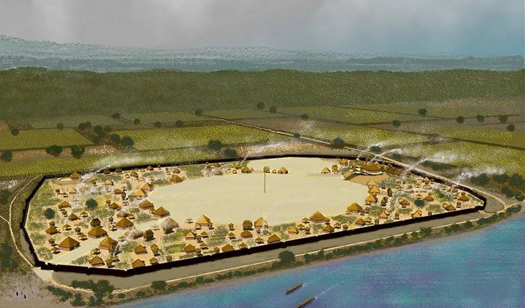
- Early colonial maps show the Kaushete (Cusatees) dominating all of the Upper Coosa and Upper Tennessee River Basins in Georgia, Tennessee and Alabama, as late as 1715.
- The Chickasaw towns and villages were spread over a vast region than included northern Georgia, northern Alabama, central and western Tennessee and western Kentucky.
Hernando de Soto Expedition
It is clearly stated in its chronicles that the De Soto Expedition spent several weeks in the Province of Kaushe (Coça) during the mid-summer of 1540. So, we can comfortably state as fact that the ancestors of the Koasati or Coushetta were living in northwest Georgia in 1500 AD. Two other towns downstream from the capital had Proto-Koasate names that cannot be translated by a Creek dictionary, Ulibahalin and Itaba. Ulibahalin means “Town – Principal – Stabbed (multiple times). Itaba means “border crossing on trail.” Late 20th century academicians equated Itaba with Etowah, but the original name of Etowah was Itula . . . very different.
Mythology from the Universities of Tennessee and Georgia
Almost everything that is wrong with the fossilized orthodoxy of Southeastern Native American archaeology today can be blamed on the sins of 20th century authority figures in their profession. Those folks just did not do their homework! They interpreted complex indigenous cultures during at least 15,000 years of history at the microscale of what particular artifacts, they unearthed at a particular spot. Once those interpretations were “engraved in stone” by the Old Guard, newer generations dare not challenge them. Specifically . . .
- 1. They never examined Colonial Period maps and only a few even utilized USGS topographic maps. The official route of the De Soto Expedition was devised by sticking masking tape to state highway maps! I was an eyewitness to that malarkey, while Executive Director of the Asheville-Buncombe County Historic Resources Commission.
- 2. If considering eyewitness accounts at all, it was the brief, highly biased, visits to indigenous communities by the De Soto Expedition in 1540. French reports from 1565 onward were ignored, even though they were far more numerous, detailed and sympathetic to indigenous cultures. The 1658 book by Charles De Rochefort contains 10 chapters on the Native Americans and natural features of what is now Georgia! There is virtually nothing during the 1600s on what is now the interior of Georgia, Tennessee and Alabama in the Spanish and British archives.
- 3. Throughout the 20th century, there was a consistent disinterest in the meaning of the town names that Tennessee, Georgia and North Carolina archaeologists were excavating. They seemed to assume that it was impossible to translate the word. If the meaning was mentioned at all, it was typically a fanciful, folkloric interpretation by 19th century travelogue authors . . . always wrong. An alternative interpretation was that “it is an ancient Cherokee word, whose meaning has been lost” . . . except, of course, in university-published Creek, Koasati, Chickasaw or Alabama dictionaries, which the anthropology professors never bothered to purchase.
- 4. Until very recently in the 21st century, “scientific facts” were defined by the archaeological profession as speculative opinions of authority figures, supported by the Old Guard. None of these speculations in the past were based on the type of multi-disciplinary analysis that urban planners, such as myself, are trained to do. It all began falling apart when the “Clovis First over the Bering Strait” belief was proved to be impossible by new archaeological discoveries and geologists.
The punishment for heresy
Dr. Arthur Kelly was forcibly removed from the University of Georgia faculty in December 1969, officially because earlier that spring, in an article written by John S. Pennington in the Atlanta Constitution, he had interpreted numerous artifacts unearthed on the Chattahoochee River as either being made in Mexico or copies of artifacts made in Mexico. Dr. Kelly showed me those artifacts at the Archaeology Lab at Georgia State University in February 1969, just before the article was published.

(Left) Arthur Kelly at Site 9FU14 near Atlanta – February 1969 – Pennington never advertised the fact publicly that he was a Creek Indian from SW Georgia, who, like most Georgia Creek kids, had grown up being told that “he was part Maya.” He was covertly trying to verify Georgia Creek traditions in his article.
In late August 1970, while on the Barrett Fellowship, I was stunned to see artifacts in the Tabasco State Museum at Villahermosa, which were almost identical to those unearthed by Dr. Kelly. They were made by Chontal Mayas, living in the coastal marshes of Tabasco.
Almost unknown in 1970, the Chontal Mayas are now recognized as master mariners and merchants, who ranged long distances in sea-going vessels with sails that closely resembled a Viking långbåt. My fellowship coordinator in Mexico, Dr. Román Piña Chan, never even mentioned the Chontal Mayas to me, even though they also occupied coastal areas of Campeche State, where he grew up.
Unstated was also Kelly’s sin of refusing to label Etowah Mounds as a “Cherokee” town. As soon as Dr. Kelly died in 1979, some new professors at the University of Georgia began pressuring the state to revise the exhibits at the Etowah Mounds Museum. The original exhibits stated that Creeks occupied the town until the late 1600s or early 1700s and occupied Northwest Georgia until after the American Revolution. The new exhibits and films suggest that the Cherokees sacked then reoccupied Etowah around 1585.
Tennessee orthodoxy
Thomas Lewis and Madeline Kneberg were University of Tennessee anthropology professors, who for three decades were heavily involved in the investigation of Native American archaeological sites in the Upper Tennessee River Basin. Lewis and Kneberg were pioneers in modern archaeological techniques. Their descriptions of the artifacts that they unearthed can be trusted completely.
Lewis’s and Kneberg’s ethnology and history assessments cannot be trusted at all. Lewis was from Minnesota. Kneberg was from Illinois. It is quite obvious from their published books and articles that they remained largely ignorant of the Native American cultures, colonial history and geography of the Carolinas, Georgia, Alabama and Florida throughout their careers.
Actually, they were also oblivious to the early history of Tennessee. They never had a clue that many Sephardic families had colonized NE Tennessee in the 1600s or that the French had both mapped the Native American towns and built a fort in eastern Tennessee during the late 1600s and early 1700s.
The Upper Tennessee River Basin was their New World. Otherwise, they traveled back to visit relatives in the Midwest or else attended national archaeological conferences in other parts of the United States.
The two adopted Tennessee academicians were unaware that the Chickasaw had occupied about ¾ of their state until after the American Revolution. The Chickasaw were barely mentioned by the couple in their books and still today are almost a footnote in the Tennessee State History textbook.
They presumed that the Uchee (spelled Yuchi in Tennessee) originated and only lived in the Cumberland Plateau of Tennessee and in some locations, south of the Hiwassee River. You can still read their version of the Yuchi’s in online references. It has become orthodoxy, but is fictional. The Uchee Migration Legend says that they sailed across the Atlantic from their homeland and first landed at the mouth of the Savannah. The huge Uchee province between the Ogeechee and Savannah Rivers was always where their principal population concentration was locate – not Tennessee.
Kneberg and Lewis also ignored the De Soto Chronicles. All of the town names and political titles recorded by the De Soto Expedition in what is now Georgia, South Carolina, North Carolina, Tennessee and Alabama can be translated by a Creek, Itza Maya, Koasati, Alabama or Chickasaw dictionary. Yet, in 1957 Kneberg and Lewis published their orthodoxy that the Cherokees had always lived north and east of the Hiwassee River in Tennessee, North Carolina and Georgia. The Cherokees had conquered the remainder of Tennessee by 1720.
The ”Creeks” were believed to be one ethnic group. The Pre-Columbian ancestors of the Creeks were assigned the name “Dallas Culture.” There was no mention of the Koasati, Cusatee, Tanasi, Tuskegee, Apeke, Chiaha, Tallasee, Chickasaw, Shawnee, etc.
Uchee town on the Hiwassee River
Late 20th century revisions
Archaeological work along the Little Tennessee River in the 1970s in association with creation of Lake Tellico forced a partial revision to the Kneberg-Lewis Orthodoxy. By this time, radiocarbon dating was available. It had not been invented, when Kneberg and Lewis did most of their work. It was determined that towns, visited by De Soto during 1540 in the Little Tennessee River Basin had varying architecture, but made the same pottery as found south of the Hiwassee River. Therefore, “Creeks” were living there in 1540. The orthodoxy was revised to say that the Cherokees “conquered” the region between the Little Tennessee River and the Hiwassee River around 1600. You will soon learn that the maps say something different.
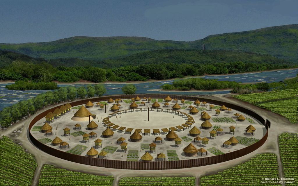
Another problem that did fit the Kneberg and Lewis mold was the pairing of towns along the Tennessee River. The towns would contain distinctly different architecture, but very similar Dallas Culture pottery and artifacts. Of course, with the Migration Legend of the Kaushete People, this is a no brainer. The document clearly states that the Kaushete and the Chickasaw liked to pair their towns. Typically, only a creek or river separated towns speaking different languages. Indeed, the “other” culture built towns that were identical to the Proto-Chickasaw town near me, the Eastwood Site and to hundreds of other Chickasaw towns around the Southeast . . . Campeche Maya style house arranged around a oval plaza with a large square communal building at one end and no large mounds.
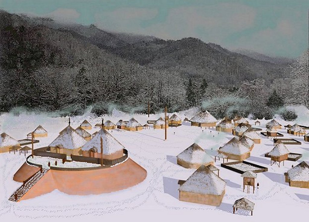
Late 20th century professors at the University of Tennessee decided that the “other” culture were Yuchi’s. They labeled it the Mouse Creek Culture. Now, that is an established fact, if you read any Wikipedia article or academic paper on the subject. Only trouble is that another name for the Tennessee Yuchi’s was “The Round Town People.” They built round houses, round temples on circular mounds and round, palisaded towns. You can’t fit a square peg in a round hole!
University of Georgia’s turn
Late 20th century anthropology professors at the University of Georgia took UT’s ball and ran with it. They labeled the territory of the Province of Coosa (Kaushe) in northwest Georgia to be part of the Dallas Culture, and thus only occupied by “Creeks.” None of their academic papers or archaeological reports mention either the Chickasaws or the Cusate/Coushetta.
The professors decided that in the period between 1540 and 1542 there was a terrible plague, which killed off most of the population of the province. Then in 1585 all of the towns and villages in Northwest Georgia were abandoned for a hundred years. By the early 1600s, a modest town, named Coosa, near present-day Childersburg, Alabama was all that was left of the province of Coosa (Kaushete).
- (Version 1) Northern Georgia was occupied by the Cherokees around 1600 AD, at the same time that they were occupying southeastern Tennessee. This version of history is championed by professors, who like to receive grants from the Eastern Band of Cherokee Indians.
- (Version 2) Northern Georgia was uninhabited for a hundred years, until the Cherokees occupied the region around 1700 AD. This version is championed by those academicians, who refuse to do research in the French Colonial archives or look at maps.
An historic map is worth a thousand words

The Spanish originally built a road to the Nachoochee Valley from St Augustine in 1646. It was soon extended to the towns of the Koasate and their allies the Apeke in the Tennessee Valley. That route is now called the Unicoi Turnpike. This map does not show any Cherokee villages in either Tennessee or North Carolina.
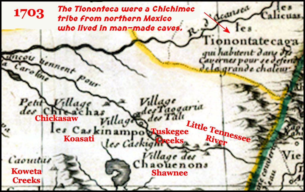
This is a detail of the Little Tennessee River Basin on a French map of North America. Caskinampo is a Koasati town name that means “Warriors-Many”. It was located on Mia-rakko Island. Mia means “lake or pond” in Koasati, Itsate Creek and Itsa Maya. It is the source of the proper nouns Miami and Maya. A word similar to Cherokee is not found anywhere on this French map..

This is the earliest map to mention the Cherokees. It showed that all of the territory from Hiwassee Island, northward to the confluence of the Holston and Hiwassee Rivers was occupied by the Cusatee (Koasati). Another section of the map showed the Chickasaw and Cusate occupying northwest Georgia

This French Army map showed many Coushate (Koasati-Conchate) villages in the vicinity of present-day Rome, GA. (center of map) Earlier French maps showed some Conchate villages in the region, but apparently those in the Tennessee Valley had moved southward in response to the Creek-Cherokee War, which began in December 1715.
After the French ceded all of their lands, east of the Mississippi River to Great Britain in the 1763 Treaty of Paris, many Koasati and Alabama villages moved west of the Mississippi, because under British ownership of their lands, they would be forced to join the Creek Confederacy in order to remain. These villages located in Louisiana, Texas, Oklahoma, Coahuila and Tamaulipas.

The first official map of Georgia in 1785 was far more detailed and accurate than anything produced by the British. It showed the portion of the state, north of the Coosawattee and Coosa Rivers to be occupied by the Chickasaws. The Cherokees owned a minuscule section of Northeast Georgia, which is now Rabun and the eastern half of Towns Counties. However, its occupants were not ethnic Cherokees, but rather Uchees and former South Americans Most of the remainder of Northern Georgia was labeled, “Upper Towns of the Creek Country – The Muskohgee Nation.” Track Rock Gap and the Nacoochee Valley were in Creek Country.
If any Koasate (Kaushete) villages remained in Georgia, apparently, they were now considered Creek towns. The Koasati had ceased to exist as a separate tribe . . . at least in the eyes of the officials of the state government.
When Rome, Ga was settled in 1832, there were three large mounds where Downtown Rome is today. Presumably, these were built by the ancestors of the Koasati. Within a few years these mound were gone. They had been used as fill soil in order to protect this new downtown from floods. No grave artifacts from the Downtown the Rome Archaeological Zone, survive from that era.
Now you know!

You always confirm what I had previously known, heard about, or read about. DNA shows I have a huge amount of Spanish in me, plus Sephardic ancestry. My known ancestors from Europe came to America in the late 1600s and always settled on the frontier, and of course, I have native ancestry which, as I’ve mentioned before, I always believed to be Creek and Shawnee. All of this seems to have converged in my physical appearance because people don’t seem to know what I am. I had a Seminole student who said to me, “You’re not white, are you?” And an acquaintance who was Cree from Canada said to my late husband, “your wife’s Native American, isn’t she?” And when I lived in Indiana, Jewish work colleagues just assumed I am Jewish. Interesting, considering my siblings were blond as children and have blue eyes.
LikeLiked by 1 person