
The archaeological zone is located between Helen, GA and Unicoi State Park. Those small rectangles below the fort site are 20th century house lots.
Because this is exactly the type location, where Itza Mayas built colonial trading towns in Mexico and the fact that it is associated with agricultural terraces and earthen mounds, the archaeological zone is probably in earlier times an Itza town site, contemporary with Track Rock Gap in Union County, GA and Itzate Gap in Rabun County, GA.
Immediately south of the knoll, Archaeologist Robert Wauchope excavated two large Late Archaic-Early Woodland mounds in 1939. They were bulldozed a few years ago by the City of Helen to make a parking lot for people tubing on the river.
The earthen ramparts of the fort were still visible in 1849, when visited by explorer Charles Lanman, who was associated with the Library of Congress and Smithsonian Institute.
by Richard L. Thornton, Architect and City Planner
In 1646, the Governor of La Florida directed that a pack mule road be built from St. Augustine to the headwaters of the Chattahoochee River, where a fortified trading post was built.
I first became aware that there was a fortified trading post and mission in the Nacoochee Valley, when reading the 1658 book by Charles de Rochefort’s ten chapters on Florida Francaise . . . now the State of Georgia. I later read more detailed descriptions of it in Florida Anthropologist Magazine and the official Florida state history text. Then, I read about it in the Virginia state history textbook. Georgia’s official textbook says virtually nothing about events in the interior of the state during the 1600s.
The Florida and Spanish sources state that in 1646, Governor Benito Ruíz de Salazar Vallecilla ordered the construction of a pack mule road between St. Augustine and the headwaters of the Chattahoochee River, where a fortified trading post was constructed at the confluence of this road with the Unicoi Trail. The road was later extended to the Tennessee River in order to establish trade with the Upper Creeks and Koasati.
The Virginia history text states that English merchant, Edward Bland, moved from Spain to Virginia in 1646. Immediately after arriving at Jamestown, he held a private meeting with Governor William Berkeley. Soon thereafter he led a small party to the southern tip of the Blue Ridge Mountains to inspect “an investment he made in a commercial enterprise.”
For the past 10 years, I have assumed that the Spanish fort was located in the flood plain of the Chattahoochee River near the contemporary village of Sautee. Infrared scans picked up the footprints of several rectangular buildings in that area.

1886 USGS Map – The town of Nacoochee is now a cornfield.
Secret location of Unicoi Trail
I recently obtained a digital copy of a USGS topographic map, published in 1886. What I thought were the footprints of 17th century Spanish buildings were actually store buildings of a 19th century town, which no longer exists. However, I was also able to obtain old maps from the Library of Congress, which showed the original Native American trade path, now know as the Unicoi Trail not passing through the Nacoochee Valley and Helen, but going through Batesville then cutting westward along the current route of Hwy. 365.
The route of the Unicoi Trail was changed to the Nacoochee Valley in 1828, after Georgia Governor John Forsyth announced that gold had been discovered there. The old route of the Unicoi Trail through rugged mountains is where I finding amazing stone ruins and many agricultural terrace complexes with LIDAR. It is another lost civilization that can’t quite be explained.
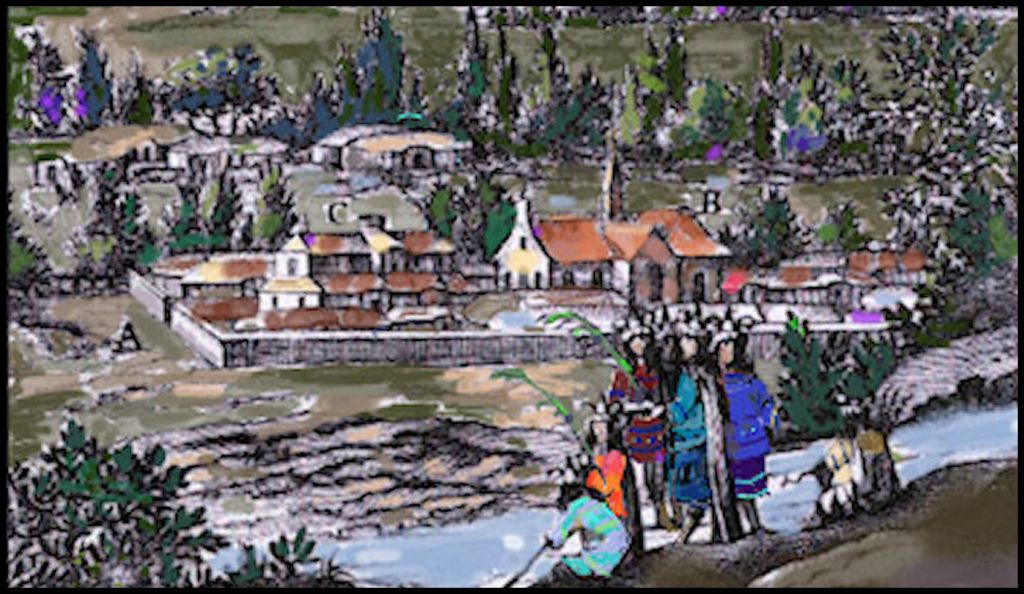
This is how 17th century Dutch engraver, Arnout Leers, portrayed the Spanish fort, trading post and mission compound on the Chattahoochee River. It turned out to be about the right size, land area, but the buildings were probably quite simple in style.
Where we go from here
Yesterday, I drove over to the archaeological zone. No ramparts of a colonial period fort were obvious. However, there is a +/- 500 feet x 350 feet (152 m x 107 m) flat, man-made terrace on the promontory, overlooking the Chattahoochee River. It is an absolutely perfect location for a fortification. Above is a flat, asymmetrical terrace overlooking it, which I suspect was Native American ceremonial or fortification site.
A series of USGS maps from 1886 to 2020, showed that no modern buildings were ever constructed on the flat terrace. In the late 20th century, it was used as a playground for rather small, Robertstown Elementary School, which is on the eastern edge of the terrace.
The next step is to obtain from the US Geological Survey a satellite image of the Spanish fort site, in the ideal spectrum of infrared light, which will pick up the decomposed wood and carbon from long gone buildings. Until then, I cannot speculate about the architecture of the Spanish and Native American buildings.
