
Were many of the mysterious movements of indigenous peoples across the landscape, triggered by localized climatic catastrophes, too brief to be easily identified by archaeologists?
It was -43 ° F. ( -42 ° C.) on the top of nearby Mount Mitchell that morning on January 15, 1985. Since 1993, there has been a radical change in the climate of the Southern Highlands. That fact alone suggests that many of the changes in the Indigenous societies of North America and Mesoamerica may have been triggered by short-term climatic changes , restricted to relatively small geographic areas.
The two articles, which follow this one, will investigate (2) The dramatic changes resulting from two “Little Ice Ages” that lasted several centuries and (3) movements of populations that resulted from the impacts of large comets on the Atlantic Ocean, catastrophic storms and volcanic eruptions.
by Richard L. Thornton, Architect and City Planner
The Secret Native American History of the Southeastern United States – Part Six

The town of Cho-te (Helen, GA) in January of 1653. English explorer, Richard Brigstock, stated that snow covered the landscape all winter. He added that the higher peaks of the Apalachen (Georgia/Blue Ridge) Mountains had snow-covered tops, most of the year. In 1568, Spanish explorer, Juan de la Bandera, wrote that these same mountains were impassible, due to heavy cover, from mid-December to late March. My has the climate of Eastern North America changed!
Someone, who has always lived with nature
For most of my adult life, I have either lived on a farm or in a rural home, next to forests, in the Southern Highlands. For that reason, I am particularly attuned to the impact of weather and changes in climate . . . certainly more so than someone, who has spent that equivalent time, commuting to a university campus, office building or factory.
Think that it is bitter cold in the Eastern United States this morning? Forty years ago, at my farm in the Craggy Mountains of North Carolina or thirty years ago at my farm in the Shenandoah Valley of Virginia, the 11° F. temperature at my Nacoochee Valley house early this morning would be quite the norm for January.
At this moment it is 21° F. both here and at the former Shenandoah Valley Farm . . . even though it is 510 miles to the north. The morning low temperature was actually three degrees warmer at Toms Brook.
Thirty years ago, if it was 12 ° F. in the Nacoochee Valley of Northeast Georgia, it would have been at least around 0° F. at our farm in the Shenandoah Valley. At both the North Carolina and Virginia farms, I was able to cross country ski down my pastures most of the time between mid-December and late March.
I still have the booklet that the Shenandoah County Agricultural Extension Agent sent me in late 1986, when I wrote him that we planned to move our goat cheese operation to the Shenandoah Valley.
The booklet states, “Shenandoah County, VA receives the least water-equivalent precipitation of any county, east of the Mississippi. Most of this precipitation comes as snow or sleet in the winter months. July is the driest month. Dairy animals must be fed hay in July and early August.“
“Since the 1700s, most rural homes in Shenandoah County have had underground cisterns for storing winter and spring precipitation for use in the summer months. It is an ideal climate for spring hay, alfalfa, wheat and barley cultivation. Unless irrigated, corn and soya beans do poorly.”
A similar US Department of Agriculture booklet, published in 2022, states, “Precipitation occurs throughout the year in Shenandoah County, but July is the wettest month. In recent decades, summer precipitation has far exceeded long-term averages, thus making the county, usually an unsuitable location for alfalfa production, but excellent for corn and soya beans.”

The Mid-1980s Climatic Disturbance
I have noticed that in contemporary archaeological literature, the authors seem to be focused on the impact of long-term droughts. At least in eastern North America, droughts may have merely been part of the climatic instability that disrupted Native American communities, dependent on agriculture.
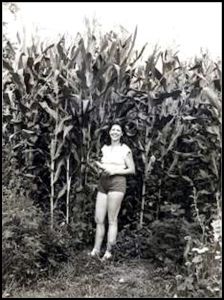
1980-84: The eruption of Mount St. Helens on May 18, 1980 had a spectacular impact on our crop of sweet corn . . . which normally grows 6 to 7 feet tall in the Appalachians. Our last frost was typically around May 10, so the seeds were just planted when the dust cloud reached the Appalachians.
It did “something” to the upper atmosphere, which made growing conditions ideal in our area. With the minimum of fertilization, our corn stalks grew from 12 to 14 feet tall. The cobs were massive. We froze what we didn’t eat and ate corn on the cob often for the next year and a half. The young woman in the photo is 5’-10” (178 cm) tall!
Then in 1981, 1982, 1983 and 1984, there were a series of major eruptions in Central America, Hawaii and South America. The largest eruption was El Chichon, the super-volcano that fried the Maya city of Palenque in 800AD.
The haze began increasingly affecting our garden crops in a negative way, but seemed to also cause heavier and more frequent snows in the winter . . . making our pastures lush in the spring and early summer. Translation? Lots of goat cheese to sell, plus whey fed pork and lambs for the freezer. North American indigenous peoples did not raise any grass-feeding livestock, however.
1985: We had a heavy snow in mid-December 1984, followed by a white Christmas and increasingly colder temperatures. It snowed several times in early January 1985, followed by the record-breaking low on January 15 . . . followed by a week of lows below or near 0 F. The weather remained cold and snowy throughout the winter and spring of 1985. We had 36 inches of snow on Easter Sunday, 24 inches of snow on May 8th and the last killing frost, plus snow flurries on June 6.
The soil was not warm enough to plant seeds until the last week in June. We experienced our first killing frost on September 6. The corn had barely formed kernels, when the frost killed everything in the garden and corn field. The pastures had stayed lush green all summer, but I had to buy hay from the state of Tennessee to make it through the winter.
That sounds like the weather of norther Ontario, doesn’t it? You know . . . that region, where the only thing grown, is trees?

1986: That winter was a little milder, both in terms of snowfall and low temperatures, but the last measurable precipitation, in the form of one inch of snow, was on February 11, 1986. Rain did not fall again on our farm until June 19, 1986. There were virtually no leaves on the trees until the last week in June! Fortunately, we received our drinking and dairy processing water from the Weaverville Water Department reservoir up on the mountain above us. So, we didn’t have to deal with a dry well.
The entire Asheville Area was classified as being in an extreme drought conditions by spring, but our situation was far worse. Over and over again, we would see snow clouds and later thunderstorms pass over our farm to drop at least some water on other parts of the Asheville Area.
There was no grass on our pastures until summertime either. The grass grew very slow even after rain came. On several days in July and August, we had record-breaking highs at or near 100° F. Normally, it rarely got above 88 ° in the summer.
By mid-summer, the Department of Agriculture became aware that there was a peculiar and very extreme drought in the Asheville, NC area. As a licensed dairy, I was awarded an entire tractor trailer load of very high-quality orchard grass and alfalfa hay from western Virginia. I noticed that milk production increased over 50%, once the goats were eating Virginia hay.
The hay was not enough to keep licensed cow dairies going. That summer 26 out of the 29 licensed cow dairies in Buncombe County, where Asheville is located, ceased operation and never restarted, after the drought ended. Cow dairies have extremely high operating costs, whether or not the cows are being milked. These dairies were bankrupt. Their farms were auctioned off.
To keep our goats and sheep healthy, I had to spend far more time finding food for them than making cheese. The rest of the time was spent being an architect. I made just enough cheese to keep our customers in the North Carolina Research Triangle, Washington, DC area and New York city happy.
The drought did not seem to bother kudzu, because the vines have roots, which can reach down to the water table. I received permission from the North Carolina Department of Transportation to harvest kudzu from their rights of way.
In addition, friends of ours in Weaverville let me graze the goats and sheep on a mountainside meadow, above our farm. The grass and weeds received enough moisture from evening fogs and passing clouds to thrive. To let the goats know that it was time to go up the mountain, I would whistle “Garry Owen,” the theme song of the Seventh Cavalry Regiment. I would continue whistling “Gary Owen” as we wound up the old wagon trail to the meadow.
When it was time to go back down the mountain, so I could do architecture work, I would whistle, “Dixie.” That became a tradition that was continued, when the entire operation moved to the Shenandoah Valley in 1987. I had no clue in 1985, that I would soon be moving to the site of the third largest cavalry battle of the American Civil War – between armies led by George Armstrong Custer, USA and Fight’n Tom Rosser, CSA!
Playing a recording of “Dixie” over the intercom in Virginia told the goats that it was time to be milked. Playing “Garry Owen” on the intercom told the goats to go trotting out into the pastures. They preferred hammer dulcimer music or French folk songs, sung by Vivi the French Courtesan, while be milked.
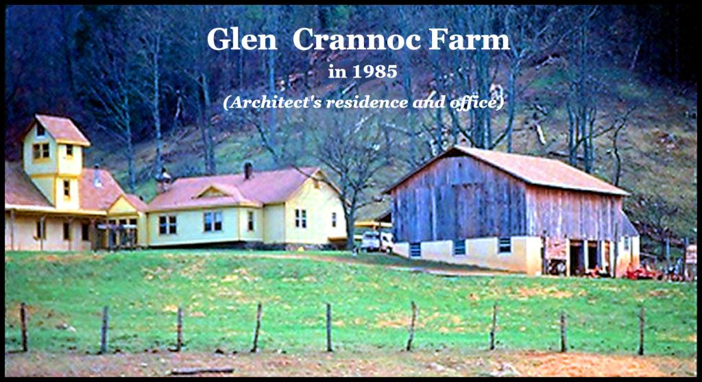
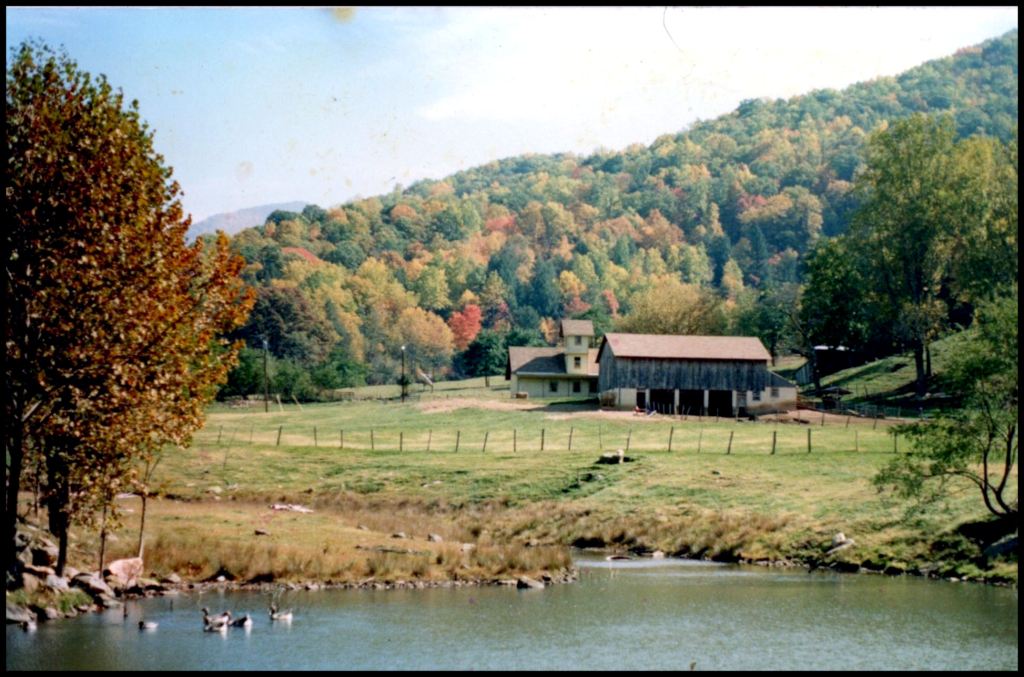
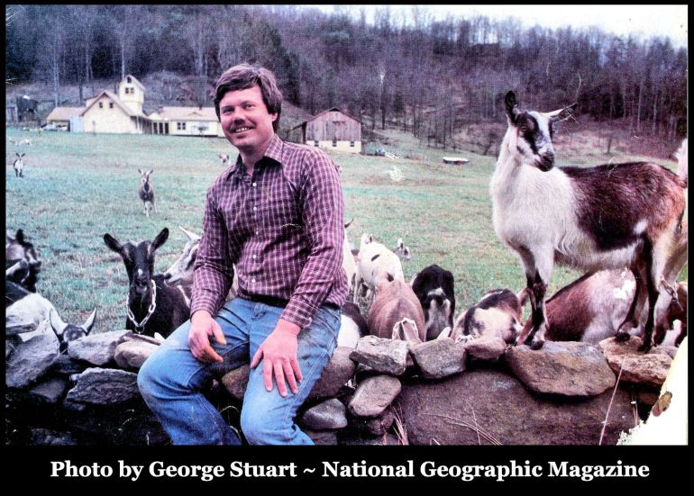
In October 1986, George and his wife, Gene, Stuart , , , both senior staff members of the National Geographic Society, spent a Saturday afternoon with us. I had first met George three years earlier, when he had photographed our farm for a book on the Appalachian Mountains. They convinced us that I would make much higher income as an architect in northern Virginia and that our cheese would sell “like hot cakes.” I moved my “tribe” 380 miles (612 km) northward. Both predictions came true.
Conclusion
Certain locations in the Southeast, especially in the valleys of the Southern Appalachians and on major rivers, seem to have micro-climates that can suddenly go bonkers, while the remainder of the continent is experiencing normal climatic conditions. The sudden abandonment of a town could well have been local climatic conditions that made the location unsustainable . . . not wars, invasions, plagues or widespread climatic changes. Likewise, the sudden re-occupation of a town site could have been after the point of time, when the location returned to normalcy.

In early autumn, 1986, the Stuarts, both nationally-recognized experts on the Maya Civilization, joined my former wife and I, plus Norwegian exchange student, Gert Erik Engelien, on a hike up to the old cabin to pick from a massive wild apple tree, which we then squeezed in my press to make fresh cider.
You know that mountainside meadow
If you have watched the movie, “The Last of the Mohicans,” then you have seen the high meadow, where I grazed my goats and sheep during the drought of 1986. In the summer of 1991, It was the location of several memorable scenes of that blockbuster movie.
Not knowing this in advance, when about to watch the movie, I already in a surrealistic situation. In the summer of 1992, I was at a movie theater in Manassas, VA, seated beside Vivi the French Movie Actress. . . who had an ancestor, who was an officer in the French army, which besieged the British at Fort William Henry. Then, in the opening scene of the movie, I was stunned to see the steep, upper mountainside my former farm in North Carolina.

- The deer hunting scene at the beginning of the movie was the upper part of my former farm.
- The wagon road where the British Redcoats, escorting Colonel Munroe’s daughters were ambushed was the old wagon road that led from my farm to the high meadow.
- The pioneer log cabin in upstate New York was a real pioneer cabin in the cove above my farm. I can’t believe that the moviemakers burned a 150 year old log cabin!

Frontier village in the old mountainside meadow
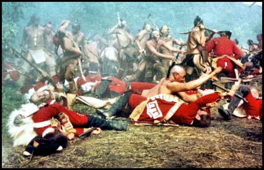
- The frontier village and the massacre of Fort William Henry survivors were in my favorite meadow.
Life is stranger than fiction!
