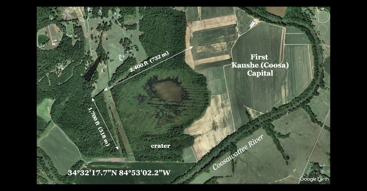
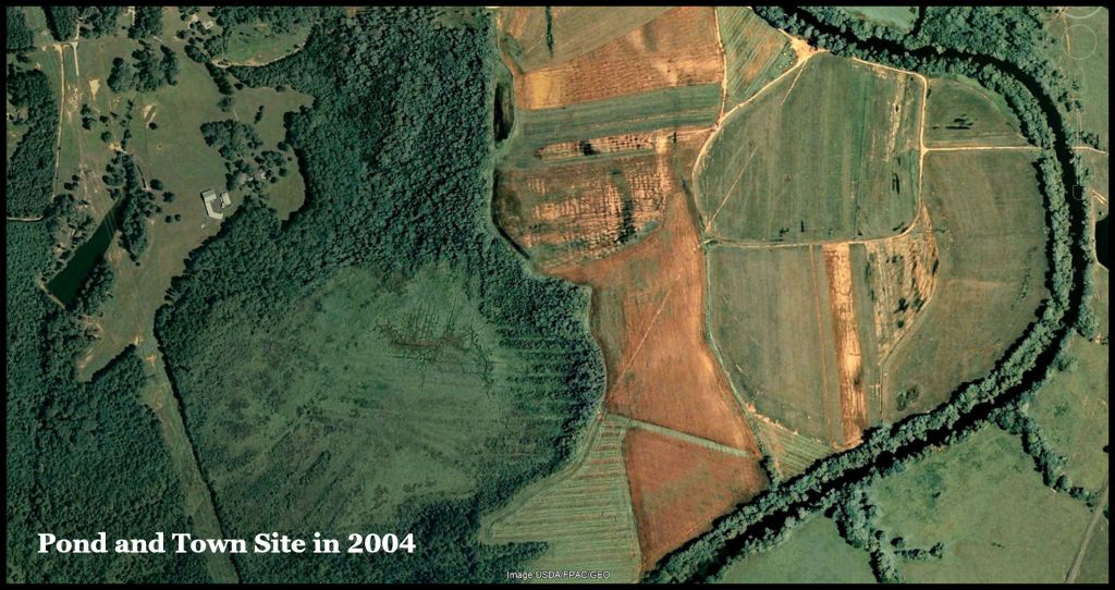
This oval, water-filled crater is one of several in Northwest Georgia, which were created by an asteroid fragmenting, as it entered the atmosphere. This fragment was large enough to have had the lethal effect of a small nuclear bomb.
The resultant pond is in the middle of very fertile bottomland, so attracted a cluster of Native American towns, occupied by three distinct ethnic groups. During the Early Colonial Period this cluster developed into a Proto-Creek metropolis . . . then a small section of the former metropolis became the capital of the Cherokee Nation for five years. in the 19th century,
It illustrates one of the caveats of LIDAR – based research. This crater, although a half mile by 1/3 mile in its axes, is INVISIBLE on a LIDAR scan! The water table here is near the surface. Water-tolerant trees and water lilies have covered most of the surface in recent years. The USGS LIDAR interpreted it as flat land.. The crater only becomes visible on high resolution satellite and infrared imagery.
by Richard L. Thornton, Architect & City Planner
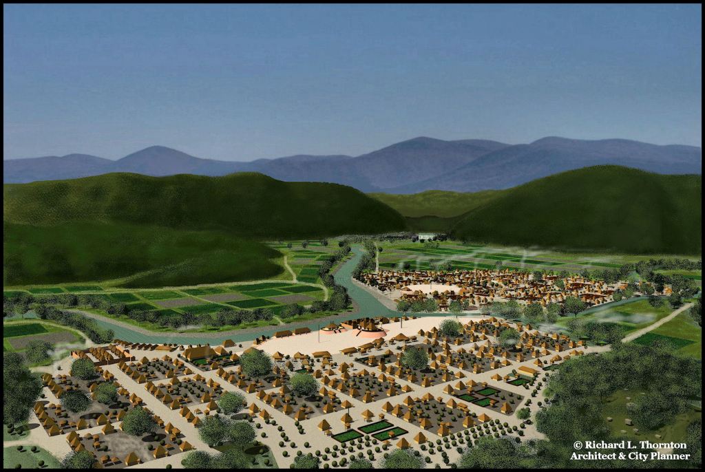
Capital of Kaushe (Kusa) that was visited by Hernando de Soto in 1540
Documenting the history of the Upper Creeks
In 2006, we learned that the US Army Corps of Engineers planned to lower the water level of the Lower Reservoir at Carters Lake, sufficiently for the mounds of the ancient capital of Kaushe (Coosa) to be visible for the first time since 1971 . . . but for only one day. Judge Patrick Moore asked me to measure and photograph the mounds on that day. He wanted me to create an accurate architectural drawing of the entire town. I still had to paddle my Mad River canoe to reach the temporary high ground, but it was a fascinating experience.
Afterward, some Upper Creek members of the Muscogee-Creek National Council asked Second Chief Alfred Berryhill, if I could find the first capital of the Upper Creeks. According to their tradition, their ancestors first lived in another town, when they arrived in what is now Georgia. I told Chief Berryhill that I would try, but couldn’t make any promises.
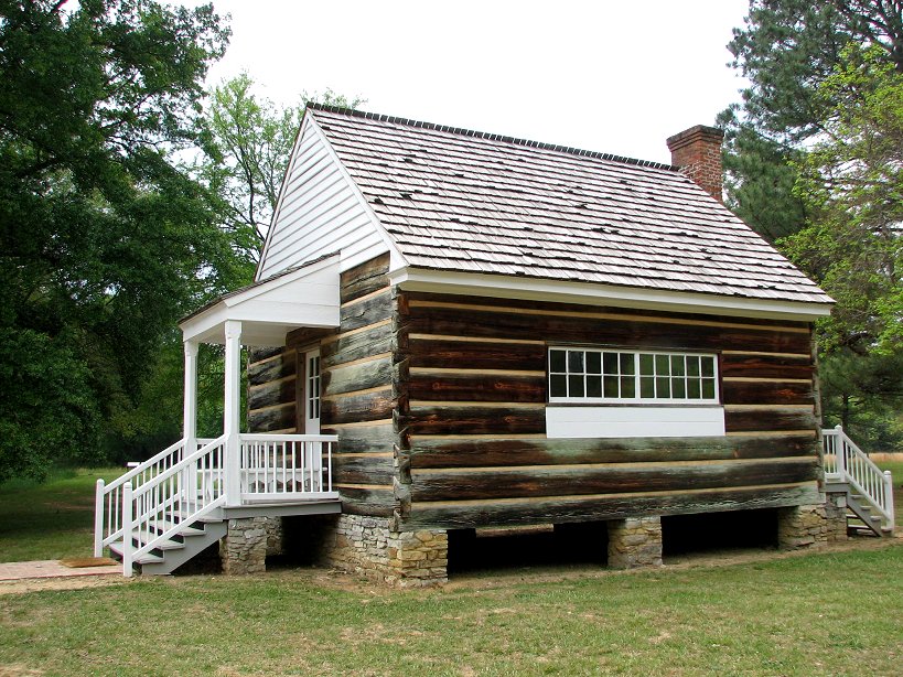
Reconstruction of the Cherokee Phoenix Newspaper office
Forgotten archaeological studies
New Echota: New Echota was the last capital of the Cherokee Nation in the Southeast. It was only occupied from 1827 to 1832 and had a maximum permanent population of about 50 people.
In March 1954, a small archaeological team, led by Georgia State Archaeologist, Dr. Lewis Larson (my former Anthropology professor) began work on the section of the former New Echota site, owned by the state of Georgia. Once the team was working a 100 yards away or less from the Worcester Missionary House, they were finding little evidence of a historical Cherokee occupation. What they found instead was a deep layer of strata, associated with pre-19th century indigenous occupations of the land by what appeared to be Creek Indians!
To his credit, Larson realized that he did not know diddlysquat about the pre-Cherokee occupation of that part of Georgia. This was BEFORE he began work at Etowah Mounds. He brought in Dr. Joseph Caldwell, who had been doing work for the National Park Service and Smithsonian Institute at Ocmulgee National Monument and Lake Allatoona, which is about 35 miles south of New Echota.
Caldwell found that the layer immediately below the shallow scattering of Historic Cherokee artifacts, were much more substantial deposits of artifacts associated with the Colonial Period Creek and Chickasaw Indians. Below that layer were artifacts associated with the Proto-Creek Lamar Culture and below that were artifacts typical of the McKee Island site near Guntersville in North-Central Alabama.

Once the slightly larger team identified likely locations to find Cherokee artifacts, they did have some success. The group recovered a Spanish coin dated 1802, crockery, household wares, remains of boots and shoes, a small quantity of lead, and 1700 other artifacts. They identified 600 items as having belonged to the Cherokee. In addition to the standard finds and remains of many buildings, Larsen and Caldwell astonished the world by discovering much of the type once used to print the Cherokee Phoenix.
The McKee Island statement caught my eye, however. It was the birthplace of the Kansa People . . . who eventually ended up out west, living in earth lodges. According to their Migration Legend, they had outgrown McKee Island then moved eastward to live near advanced peoples, who taught them agriculture. There are several key words in the Kansa (or Kaw) language, which were borrowed from Chickasaw. Everything was falling together.
Yes, that is right. The State of Georgia ignored the work of its own archaeologists and instead tells visitors to the New Echota Museum that the Cherokees had lived there for hundreds of years. No mention at all is given of the thousands of Creek artifacts found UNDER New Echota.
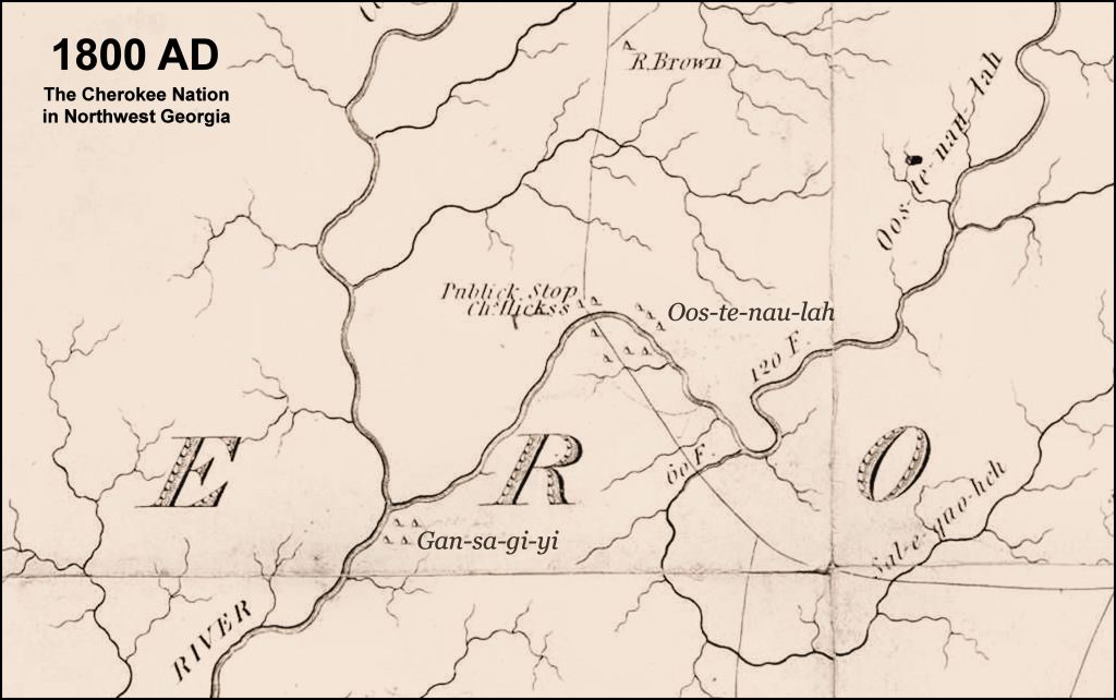
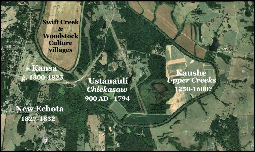
I looked closely at an 1810 map of Georgia. It showed a Kansa (Gansagiyi in Cherokee) village where New Echota was to be built and a former Chickasaw town, Ustanaula, to the east.
Dr. Kelly’s archaeological survey
I found my old copy of the archaeological survey of the Coosawattee River Valley by Dr. Arthur Kelly. This was done in the 1960s for the US Army Corps of Engineers in preparation for the construction of Carters Dam. Kelly was hired to identify all archaeological sites along the Coosawattee River, westward to New Echota.
Kelly found the original Georgia capital of the Cherokees during the 1790s immediately west of the much, much larger Creek town of Kusa (Kaushe, Coosa). It was just a cluster of perhaps a half dozen houses and a ball field.
Moving westward, Kelly found very little evidence of a Cherokee presence along the Coosawattee River. Village sites with Swift Creek, Lamar, Dallas or Mouse Creek style artifacts were regularly spaced along the river.
About two miles east of New Echota, Kelly encountered a large bend in the river, containing a dense array of Early Lamar style artifacts. He estimated that the town had been founded around 1200 to 1250 AD and remained occupied until the end of the Colonial Period or later. The capital visited by the Hernando de Soto Expedition was located near the proposed site of Carters Dam and was founded around 1375 AD. This appeared to be the original capital.

I drove to the beautiful archaeological zone and photographed it for the folks in Oklahoma. I saw nothing that could possibly be a mound, however. In looking for a mound, I came upon a large pond. It seemed odd that such a large body of water would not have a stream flowing in or out of it. Later, I obtained a satellite photo of it from the Soil Conservation Service, taken when the field was divided up into smaller fields.
Here are the locations of the town sites.
Now you know!

Excellent information! I love learning more about the early cultures in my home state. It is disturbing that solid research has not been acknowledged by the historical societies and pak services. The museums should be displaying the older artifacts and labeling them accurately by area and culture at the New Echota Museum and the Etowah Mounds State Historic Site, among the numerous ones across the state. They could all learn from the timeline displays in Mexico City at the Museo Nacional de Antropologia. So glad you worked there at one of the best!
On another note, it is surprising information that the pond is shown as flat land by LIDAR. Wow! Glad you could identify it with satellite data and infrared. Keep up reporting!!
Mary Jane Parker Real Estate Broker*, *Retired mjparker.broker@gmail.com mjparker@mindspring.com 404-274-6319
LikeLiked by 1 person