
They caused massive changes to the coastlines of Florida and North Carolina
In recent years, geologists have found proof in the soils of Eastern North America and the Caribbean Basin . . . plus the ice of Greenland . . . that in 539 AD and in 1014 AD, relatively large objects from space crashed into the North Atlantic, causing massive losses of life. They are also finding evidence of many more impacts on the landscape of Eastern North America, These may have only been fatal near the point of impact, but still altered the cultural beliefs of Indigenous Americans.
The Secret Native American History of the Southeastern United States – Part 14
by Richard L. Thornton, Architect & City Planner
There is something really strange about Florida’s Atlantic Coast!
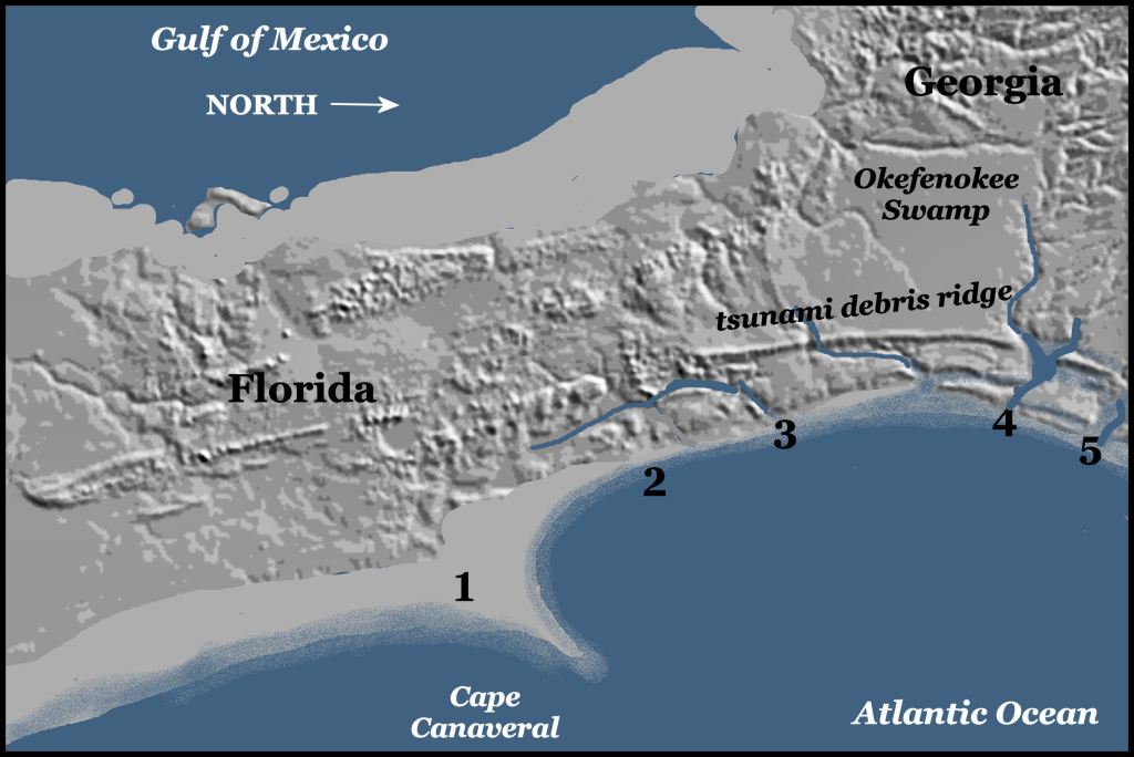
The new USGS LIDAR map of the United States reveals a terrain that goes unnoticed as motorists cruise up and down Florida’s Atlantic Coast on I-95. What appears to be a pancake flat landscape actually has the vestiges of a coastline very similar to that of Georgia’s and South Carolina’s . . . low elevation barrier islands separated by river outlets and wide expanses of tidal marshes from the mainland. So what happened to the islands and tidal marshes? Well, you wouldn’t have wanted to be vacationing at Daytona Beach or St. Augustine, when the change occurred.
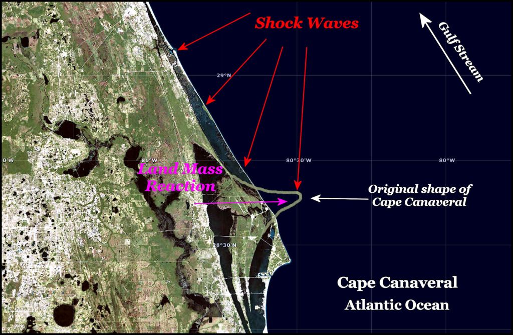
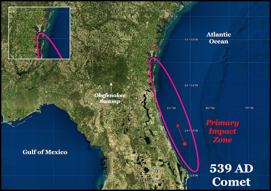
(1) Cape Canaveral should not be there! - Cape Canaveral juts out into the Atlantic Ocean in the face of one of Earth’s most powerful ocean currents, the Gulf Stream. The northern side of the cape forms the bottom of an ellipse. The top of the ellipse is formed by the mouth of the Altamaha River in Georgia, where the “South Atlantic Ridge” that we discussed in a previous article is at it’s highest point.
(2) An ancient river once drained most of northern Florida – One can see the valley of a river that once flowed into the Atlantic Ocean at St. Augustine, FL. Its northern fork once flowed southward from the Okefenokee Swamp then joined the main river at St. Augustine Bay.
(3) Jacksonville is a manmade seaport – Some massive act of nature blocked the mouth of the ancient river and caused part of its water to flow northward until it broke through the new dam, built by Mother Nature, near Jacksonville, FL. The mouth of the St. Johns River was invisible in Colonial times and not accessible by ocean-going ships until 1860, when a channel dredged by the US Army Corps of Engineers opened up.
(4) Missing barrier islands on Florida’s northeast coast – Today there are no islands on Florida’s coast from the mouth of the St. Johns River southward to Cape Canaveral.
(5) Deepest harbor and highest ridge – St. Andrews Sound, Georgia is the deepest and largest harbor on the Atlantic Coast of North America. Sixteen miles inland the South Atlantic Ridge reaches 85 feet. This is why the US Navy built the Kings Island Submarine Base there. The reason that no large city on St/ Andrews Sound is that until I-95 was built, it did not have regional transportation access. In a very early example of socialism, the State of Georgia built a rail system, which intentionally channeled all products from the interior of the Southeast to Savannah . . . thus intercepting exports that might have gone to Charleston, SC.
The geological links to cultural changes in North America and Mesoamerica
What caused the sudden decline of the Swift Creek Culture in the Southeast and the Hopewell Culture in the Midwest? What caused the 50% decline in the population of Campeche State, Mexico that was followed by the appearance of Campeche style houses in Northeast Georgia around 600 AD. Is there a connection between the mind-boggling changes in Florida’s and North Carolina’s shore line with disappearances and movements of Indigenous Americans elsewhere?

Is the massive 2000 feet by 1200 feet (610 m x 366 m) Celestial Serpent earthwork in the Nacoochee Valley of Georgia a monument to a section of the comet or asteroid that fell on the Valley? It is directly aligned to the ellipse-shaped impact zone in Florida. In March 2013, an international team of scientists, parked next to this earthwork, discovered a gravitational vortex immediately to the south. Eyewitness accounts of other impacts in Mexico described them as appearing to be spiraling serpents of fire, when aimed directly at you.
When a large meteor, asteroid or comets strikes the ocean, intense heat and mechanical energy, plus several gases are released into the atmosphere. These gases are trapped in the Arctic and Antarctic ice caps. Volcanic eruptions leave several chemical traces in the ice caps; primarily sulfates. There were enormous ammonia spikes in 539 AD and 1014 AD. Volcanoes do not emit ammonia.

In 2009, Dallas Abbot of Columbia University found nodules associated with a major asteroid or comet strike at the “500s AD level” of the Greenland Ice Shelf. She insisted that either a comet or asteroid played a role in the climatic catastrophe of the Sixth century, since volcanoes do not emit ammonia. She also found nodules in the Caribbean Basin. The concentration increased the closer one came to the Florida Coast.
In 2010 a Greek archaeologist, Dr. Amand Laoupi, reinforced Abbot’s theories by revealing a second ammonia spike in the Arctic ice shelf in 539 AD. The spike was clearly unrelated to Icelandic volcanic activity.
In 2013, Dr. Robert Dull of the Environmental Science Institute at the University of Texas in Austin announced results of tests, which indicated that the Ilopango volcano in El Salvador kicked off a period of cooling in the world’s climate. In 536 at least two large volcanoes also erupted in Iceland. For decades afterward a bluish haze over the northern hemisphere and tropics caused famines and probably a horrific plague.
A strain of bubonic plague appeared in China and by 540 AD wiped out somewhere between 30% and 50% of the population of the old Roman Empire. This “Little Ice Age” ushered in the Dark Age of Europe and made the Eastern Roman Empire far more vulnerable to future invasions by Islamic armies. There is plenty of evidence of cultural decline in eastern North America and Mesoamerica during the Sixth century AD, but the chronology is slightly different.
In 2013 two scientists in Japan, Haruna Sugahara and Koichi Mimura, finally answered the question of whether the catastrophic strikes in 539 AD and 1014 AD were meteors or comets. It was already known that comets were essentially dirty ice balls that contained the type of debris which could become the type of nodules that Dallas Abbot had found in several locations along the Atlantic Coast and in the Caribbean Basin.
In 1994 chunks from the Shoemaker-Levy Comet crashed into Jupiter, creating massive explosions, visible on earth. The largest explosion was the width of the planet Earth. The Japanese scientists’ analyzed the electro-magnetic waves emitted by these explosions. Shoemaker-Levy contains large amounts of frozen ammonia. A super-sized comet striking the Atlantic Ocean could have both caused gargantuan shock waves and filled the atmosphere with ammonia.
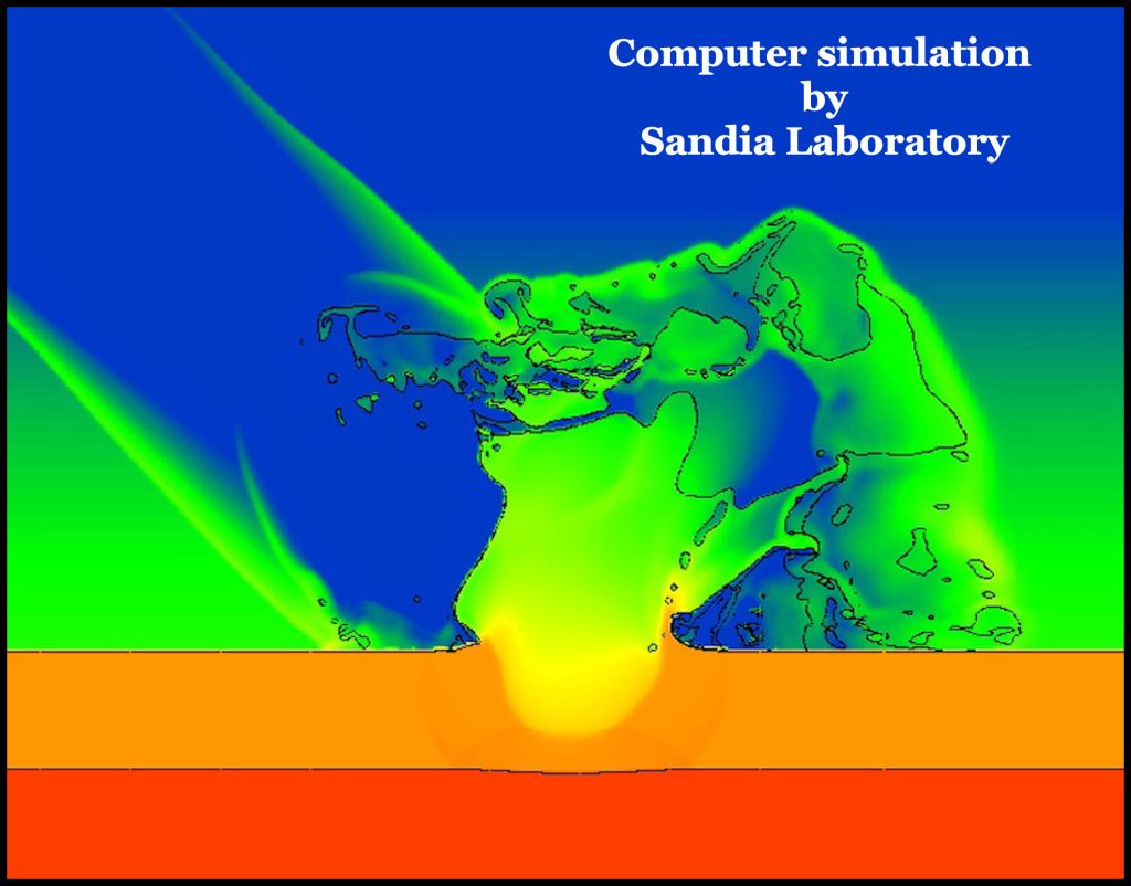
The recent computer simulations by the Sandia National Laboratory found that superheated steam, ammonia and the solid particles within a comet would be ejected at sub-orbital velocities into the edge of the exosphere (space.) This would cause them to be more equally spread around the globe than the pollution from volcanoes. The combined effect of both the comet and the volcanoes would be sufficient to cause a Little Ice Age on earth AND chemically disrupt the photosynthesis of plants for many decades. The presence of ammonia high in the atmosphere would explain the blue haze that enveloped Earth for several years after the 1014 AD.
The Second Impact on the North Atlantic Ocean
New York forensic geologist, Dallas Abbott of Columbia University has also found evidence that around 1014 AD, a swarm of large meteors or comet debris struck North America and the Atlantic Ocean, causing both a mega-tsunami and local, cataclysmic meteor damage. She is employed by the Lamont Doherty Earth Observatory at Columbia. She has found evidence of a large meteor or comet strike in the middle of the Atlantic Ocean, which hurled extraterrestrial debris over 3800 km (2361 miles) to a bog in the Black Rock Forest in New York. The material was dated to around 1014 AD. Abbot also found debris from a meteor or comet strike in the Lesser Antilles in the Caribbean Basin that also dated to 1014 AD.
Were there any historical documents, which correlated with Abbot’s discoveries? I dug further into available historic and anthropological resources. Abbot’s statements are backed up by several European archives, geological evidence and sudden cultural changes in the Southeastern United States, Caribbean Basin and Ohio River Valley.
The Anglo-Saxon Chronicles

“1014 AD – This year, on the eve of St. Michael’s day (September 28 – Julian Calendar), came the great sea-flood, which spread wide over this land, and ran so far up as it never did before, overwhelming many towns, and an innumerable multitude of people.”
Other Medieval records confirm Abott’s interpretation of the geological evidence. William of Malmesbury in The History of the English Kings (vol. 1) states “A tidal wave, of the sort which the Greeks call euripus, grew to an astonishing size such as the memory of man cannot parallel, so as to submerge villages many miles inland and overwhelm and drown their inhabitants.”
A sea-flood is also mentioned in the Chronicle of Quedlinburg Abbey (Saxony), where it states many people died as a result of the flood in the Low Countries (Juteland, Holstein, Friesland, the Netherlands and Belgium) in 1014.
Impact on North Carolina’s coast
In 2007 North Carolina geologists published evidence that the coastline of their state had once been protected by a chain of barrier islands and tidal marshes such as those that shield the mainland of South Carolina and Georgia. They stated that either a Class 5 hurricane or a tsunami had destroyed these islands in the 11th century. The authors were NOT aware of the massive 1014 AD impact on the Atlantic Ocean, which, of course, occurred in the 11th century.
[Culver, et al, The Sedimentary Record, “Barrier Island Collapse in the Late Holocene, Outer Banks, North Carolina, USA” - Volume 5, No. 4, December 2009]
The Outer Banks are the remnants of these islands, which were splashed back by the ripples of a tidal surge or tsunami. These geologists are further concerned that multiple fractures in the Continental Shelf could cause the Outer Banks to slide into the ocean, creating a mega-tsunami. Evidence of such a mega-tsunami during the early 11th century in the Atlantic Ocean is undoubtedly also lurking along the coastlines of Virginia, South Carolina, Georgia and Florida.
Could these horrors ever happen again? Yep! The geologists all agree that for unknown reasons, the Caribbean Basin and North America have been in the bullseye of Mother Nature for hundreds of millions of years. The impact that wiped out the dinosaurs, hit the northern Yucatan Peninsula. It is a matter of when, rather than if.
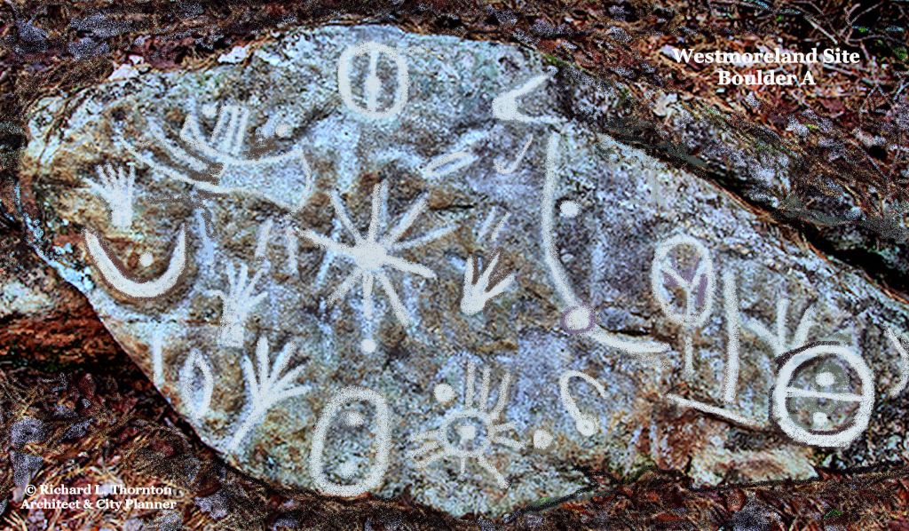
This petroglyph, seven miles north of my house, contains in the center, a bright light or explosion in the sky with the symbol for a meteor or comet to its right. The symbols are from a Swedish Bronze Age writing system.

Devastating and frightening even reading about the comet Richard. Let alone the people who had to cope with it.
LikeLiked by 2 people
You’re on fire and firing on all cylinders with this article Richard my extreme compliments! As a Savannahian and regular traveler to North Carolina’s coastal world along with South Carolina’s, it makes this one feel all the more closer to home! Looks like we may have to embrace a fire serpent death with a smile at some point even if I’d much prefer surviving to build the next effigy homage instead! Question – as to the 85 ft debris field shelf idea, any estimates on how fast that wave was moving?
LikeLiked by 1 person