
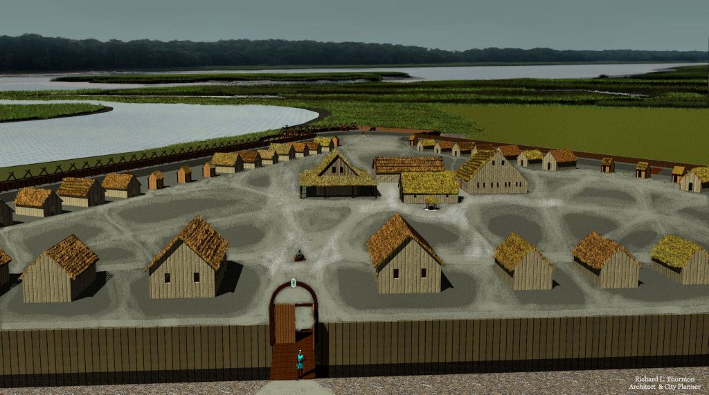
+ Architectural drawings of the real Fort Caroline
In September 1565, approximately 1000 French Huguenot colonists reached the shores of Georgia. They would live in the real Fort Caroline for several months, while colonists, who had arrived in 1564, built a town on a natural terrace overlooking the Oconee River. That site is now the University of Georgia!
Simultaneously, Sephardic Jewish leaders in the Netherlands, England and Scotland were planning to build New Jerusalem where Macon, GA is today. The New Temple was to be built atop Browns Mount in Ocmulgee National Historical Park, which is about the same latitude as the Temple Mount in Jerusalem. LIDAR images suggest that that project was actually begun.
The Forgotten Native American History of the Southeastern United States – Part 16
by Richard L. Thornton, Architect & City Planner
When I woke up this morning, I realized that if the previous articles in this series was confusing enough, but I really needed to provide an overview of what was simultaneously going on in Southeastern North America during the chaotic period of the late 1500s and much of the 1600s. We will then proceed to the slide shows of French Colonial architecture. It was starkly more sophisticated that the crude structures initially erected by Spanish and English colonists.
My primary sources of information are the memoirs of Captain René de Laudonnièrre (Commander of Fort Caroline, 1564-1565), Captain Domique de Gourgues (commander of the punitive expedition against the Spanish in 1568), plus ten chapters of a book, written by Charles de Rochefort in 1658 about what is now Georgia and western North Carolina. In addition, I perused letters and books, written by Sephardic leaders in the Netherlands during the late 1500s and early 1600s.
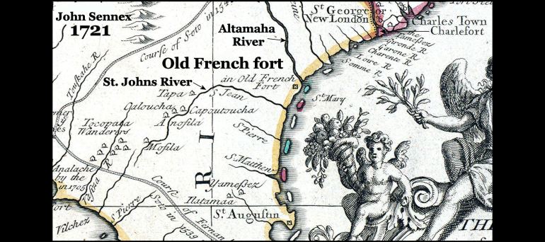
Fort Caroline was NOT in Florida
All of the French authors above placed Fort Caroline at the latitude of where today I-95 crosses the Altamaha River near Darien, GA. All historic French, English, Dutch and Spanish maps place Fort Caroline on the south side of the Altamaha River in Georgia. No map ever placed Fort Caroline in Florida and in fact France never claimed land south of the St. Marys River, which is the boundary between Florida and Georgia.
While staying at a plantation on Broughton Island, GA in 1776, explorer William Bartram visited the ruins of Fort Caroline and Fort San Mateo. He mentioned his visit and described the earthworks in his famous book. Maps, published as late as the early 1800s stated that the original name of the Altamaha River was the May River.
All of the Native American tribes, which bordered Fort Caroline and the first location of St. Augustine were Georgia tribes, primarily of South American origin. Most fled northward or westward, when the Spanish established forts and missions of the coast of Georgia. They eventually joined the Apalachen Confederacy then in 1717, joined the new Creek Confederacy. For example, the Thamacoggan moved to the Middle Oconee River in the Piedmont . . . a location that is now in Jackson County, GA (NE Metro Atlanta). The original name of Jackson’s county seat was Thamacoggan!
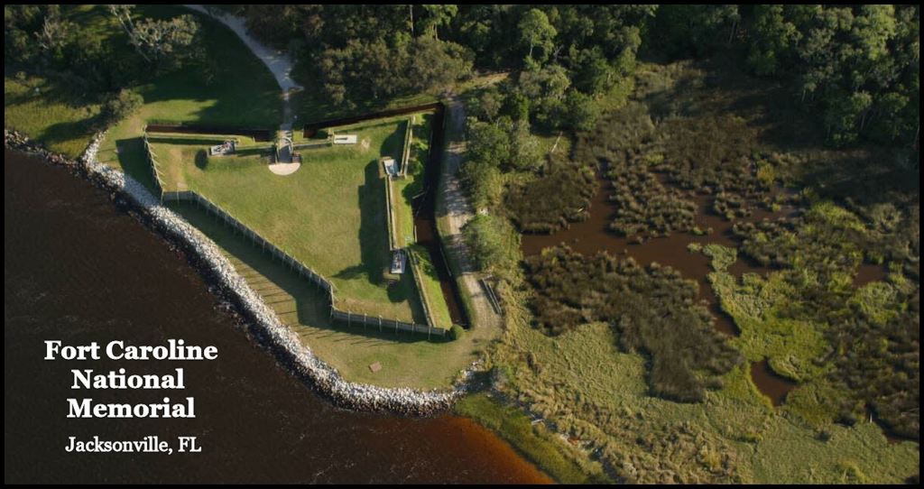
This 1/12th scale replica is located on the banks of an artificial channel, dredged by the US Army Corps of Engineers in the late 1850s. Jacksonville, FL was not accessible by ocean-going ships until 1860! Fort Caroline National Memorial is six miles from the ocean. The real Fort Caroline was 11 miles from the ocean, on one of the many navigable channels of the Altamaha River. The mouth of the May River was defined by two large islands and one smaller island, three miles in diameter (Sapelo Island). There are NO islands at the mouth of the St. Johns River.
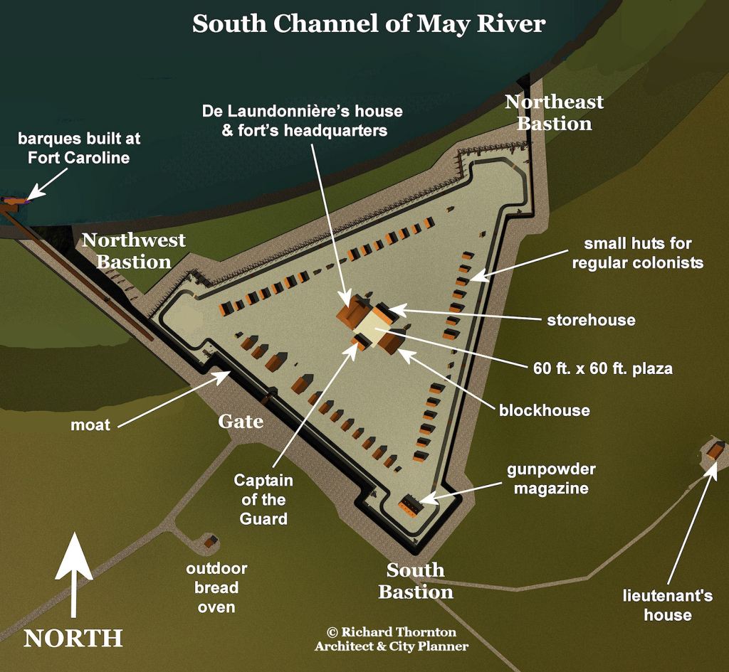
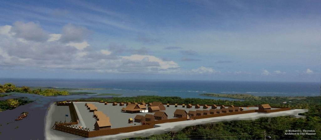
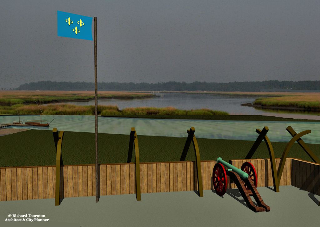
What Fort Caroline actually looked like
–
–

–
–
View, looking northward, of the many channels of the Altamaha River as it flows into Altamaha Sound. Multiple French, Spanish and English eyewitness descriptions of the May River, plus latitude-longitude calculations bear no resemblance whatsoever to the St. Johns River in Florida.
It should be understood that the placement of an inaccurate 1/12th scale replica of Fort Caroline on the St. Johns River in Jacksonville, FL by the National Park Service in 1961 was the result of political payoffs by President Harry Truman in 1950 and President Lyndon Johnson in 1961.
In 1950, NPS officials balked at labeling a 50 acre track, given to them by the City of Jacksonville . . . . Fort Caroline National Historic Site, because no 16th century earthworks or artifacts have ever been found there. That is why it is named Fort Caroline National Memorial. The real Fort Caroline enclosed about 50 acres and was meant to protect a town of about 1000 residents.
At the time, some NPS staff archaeologists remembered that in 1934, Smithsonian Institute archaeologist, James Ford, had found a treasure trove of 16th century French and Spanish artifacts at the Georgia location. Unfortunately, Ford misidentified the still-visible earthworks of Fort San Mateo as a trapezoidal Indian mound and did not actually excavate within the fort. A trapezoidal earthwork, the size of Fort San Mateo, is still visible with LIDAR and infrared scans.
The original Nouvelle France
In the spring of 1565, Lt. LaRoche Ferrière signed a treaty with the High King and National Council of the Kingdom of Apalache in the Apalachen (Georgia) Mountains, making that Native American nation a military ally and commercial partner with the Kingdom of France. A distinct difference between the French Protestants and the Spanish, was that the French recognized Native American land ownership and purchased it from the owners. The Spanish consistently seized what they wanted and treated Native Americans at best, as serfs or slaves. The terms of the treaty were:
- Apalache would immediately grant to the French a natural terrace overlooking the Oconee River at the location, which was at the end of cargo canoe navigation. The site for a principal town and trading post was immediately east of the Georgia Gold Belt and about two days walk from the Apalachen Mountains.
- French farmers could cultivate the lands near the town in an area roughly equal to Athens, GA today.
- The Apalache and French (predominantly Protestants) would become military allies. The French would furnish the Vehite (professional Apalache soldiers) firearms and steel weapons. The two peoples would join together to conquer the Ustanauli, who were arch-enemies of the Apalache and controlled the Savannah River trade route between the ocean and the mountains.
- All single French adults will marry Native American spouses.
When Lt. Ferrière returned to Fort Caroline with the good news, Captain De Laudonnièrre was desperately awaiting the arrival of a large fleet of French warships and cargo ships, commanded by Captain Jean Ribault. Fort Caroline’s colonists had run out of food and was very short on gun powder and lead balls for their muskets and arquebuses. The fleet also carried over 900 new colonists for Nouvelle France, including women. No women had accompanied the approximately 250 Fort Caroline colonists.
As soon as Ribault’s fleet arrived, Ribault would become commander of Fort Caroline. De Laudonnièrre planned to lead a large portion of the original colonists up the May River to begin construction of the planned capital . . . and to also begin mining gold. Now THAT would make the Kind of France very happy and cooperative with the Protestants.
Ferrière mentioned that he had visited the western fork of the May River, which was much more densely populated than the eastern fork, where the French planned to settle. One section contained many ancient temples (Ocmulgee Mounds) and was the same latitude as Jerusalem. It would be an ideal location to establish the Jewish colony of New Jerusalem for Jewish refugees from Europe.
The Sephardic Jews would naturally hate the Spanish, because of the evils done by the Spanish Inquisition. As such, they would be an ideal barrier between the Spanish Catholics, who were trying to colonize the Florida Peninsula and the French/Swiss/Dutch Protestants in the Piedmont foothills and Apalachen Mountains.
Ribault’s fleet eventually arrived at Altamaha Bay in September 1565. By then, the Fort Caroline colonists had given up hope and had already dismantled much of the fortifications in preparation for returning to France. Then a Spanish fleet appeared off the mouth of the Altamaha River. Spanish spies with the colony had slipped away then informed officials in Havana, where Fort Caroline was located.
The Spanish had arrived too late. They were greatly out-gunned and out-numbered by the French, once Ribault’s fleet had arrived. The Spanish fleet then started sailing southward as the weather worsened.
Stealing catastrophe from the jaws of victory
Captain Jean Ribault managed to steal catastrophe from the jaws of victory. Instead of staying in the harbor until the hurricane or severe tropical storm passed, he announced plans to overtake the Spanish fleet and destroy it. Since his fleet greatly outnumbered the Spanish, that might have been possible in good weather, but . . .
Ribault stripped Fort Caroline of its trained soldiers and most of its cannons to supplement those on his ships. He sent some of the non-combatants in his fleet to the fort, but inexplicably kept the women on the ships. Since the timber palisade had been removed from the south side of the fort, it was totally helpless if attacked by land.
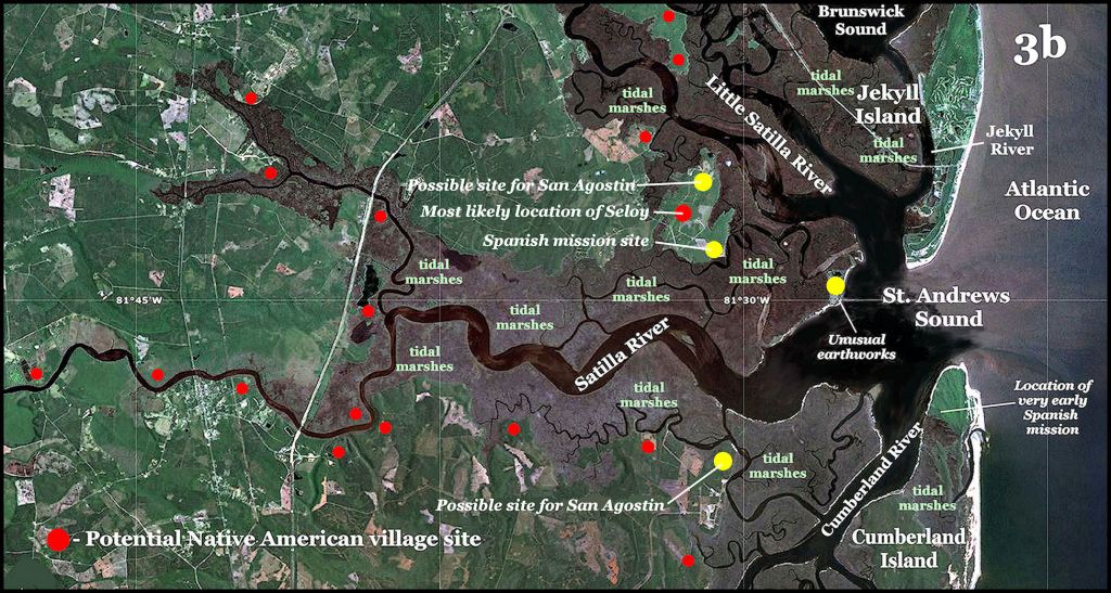
The small Spanish fleet, commanded by Pedro Menendez turned right into St. Andrews Sound to avoid the worst winds of the tropical storm. St. Andrews is the deepest port on the Atlantic Coast. Menendez’s large flagship could enter there, but not into St. Augustine Sound, Florida.
If one reads the original Spanish language reports by Menendez to the king, he states the latitude of peninsula between the North and South Satilla Rivers to be 31 °. This was the location of St. Augustine until March 1566, when the colony moved to its current location in Florida. Online English translations by Florida universities of these documents change the latitude and physical description of the first Spanish settlement to match St. Augustine, FL, rather than St. Andrews Sound, GA.
Ribault charged like a mad bull into the tropical storm, never noticing that he had passed the Spanish fleet. Most of his ships were wrecked along the coast of Georgia and Florida. Most of the occupants of the ships were drowned. Those, who made it to the beach were sooner or later rounded up by the Spanish and summarily executed with swords . . . unless they were Roman Catholics.
Menendez then led his conquistadors northward from St. Andrews Bay to attack the bared south face of Fort Caroline at night during the storm. There were no sentries. Most of the occupants of the fort were killed in combat. Those adult Protestants, who surrendered were hung from trees near the fort. Captain René de Laudonnière led a small party, including artist Jacques Le Moyne, which fought its way out of the fort then hid in the marshes. They were picked up by a ship, captained by Jacques Ribault, son of Captain Jean Ribault, who was executed by the Spanish.
Ten members of the Fort Caroline colony, were sleeping with their Native American girlfriends in villages away from the fort on the night of the attack. Even though the Spanish put a bounty on their heads, six managed to paddle up the Altamaha to the Oconee River then up the Oconee to the frontier of the Kingdom of Apalache. They were granted asylum, with the provision that they marry Apalachete women.
The adopted Frenchmen immediately began introducing European technology to the Apalachete. The High King and his family converted to Protestant Christianity within a few years. The presence of friendly Europeans was so beneficial to the kingdom’s economy and military power that its leaders began welcoming Protestant and Jewish immigrants to their land . . . again with the provision that single adults marry Native spouses.
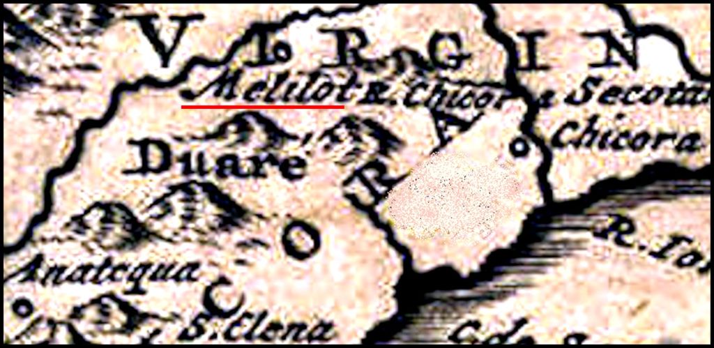
The town of Melilot, on one of the tributaries of the Oconee River, was created as a settlement for Europeans in 1567. Later editions of a book, written by Charles de Rochefort, contain a long letter, written by Edward Graeves, one of the leaders of Melilot. It was dispatched on January 6, 1660.
The location of Melilot is probably the ruins at Little Mulberry River Park in Gwinnett County, GA. It stayed on European maps until after the horrific 1696 Smallpox Plague.
Now you know!

Two things that I should tell the reader. The book, “Three Voyages” by Congressman Charles E. Bennett, claims on the cover to be an accurate translation of the French language memoir by Captain René de Laudonnière, entitled, “Four Voyages.” That is a bald face lie. It is a modernization of a faulty translation by Elizabethan scholar, Richard Hakluyt, in 1584, but contains the same translational errors. Bennett went a step further, however, and redacted or changed all statements in Hakluyt’s translation which placed Fort Caroline on the south side of the Altamaha River in Georgia. He also created fake maps and left out Hakluyt’s map. All French, Spanish, English, Dutch, German and American Colonial maps place Fort Caroline on the south side of the Altamaha River in Georgia.
LikeLiked by 1 person
Life IS like a box of chocolates. Had I not started the second licensed goat cheese creamery in the USA in 1981 near Asheville, NC, I would have not built the nation’s first federally-licensed goat cheese creamery in the Shenandoah Valley of Virginia during 1989. Had I not built the Virginia creamery, I never would have been invited to the annual Christmas Party for Smithsonian Institute senior staff in 1990 to sample my cheese. Had I not attended the party, I never would have been asked by a lovely French actress to sample my cheese with her French wine. Had I not fallen in love with that actress . . . who was a History graduate from the Sorbonne, I never would have become fascinated with French history . . . in particular, the Colonial Period.
LikeLiked by 1 person