
In 1933, the State of Georgia tried to give the probable sites of Fort Caroline and Fort San Mateo to the National Park Service. The offer was declined because of a report from a young man, who only had four quarters of introductory Liberal Arts education. Numerous 16th century French and Spanish artifacts have been found at that location near Darien, GA, while none have been found at the fake Fort Caroline, near Jacksonville, FL.
by Richard L. Thornton, Architect & City Planner
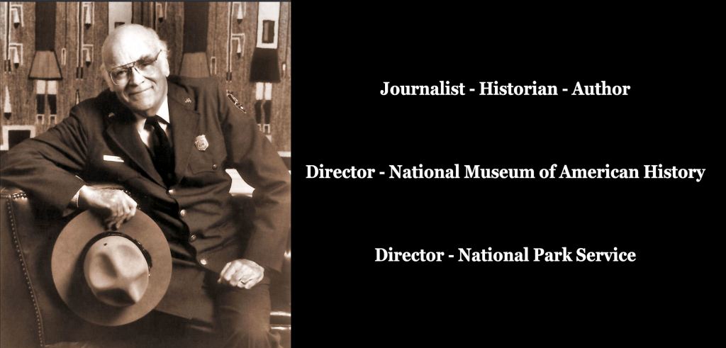
I first met former National Park Service Director, Roger Kennedy, at a Smithsonian – National Geo Administrator’s Christmas Party in December 1990. At the time, he was Director of the National Museum of American History. He and his wife, Frances, later drove out to visit my Colonial Era farm in the Shenandoah Valley . . . which then was being studied by NPS archaeologists and historians to become a key property in the proposed Shenandoah Battlefields National Park.
In March 1993, Roger appointed me to be on the Advisory Council of the American Battlefield Protection Program. In 1995, he and his staff awarded the largest ABPP grant that year to the 11-mile long Brushy Mountain Defense Line in NW Metro Atlanta. I wrote the grant application and was working on the preservation of this structure . . . which is the largest fortification in the Americas..
Then, in 2010 and 2011, until his death from cancer on September 30, 2011, Roger subsidized my camping journey across the Southern Appalachians in search of the Early Colonial Period’s lost history. In the little cabin, where I was based, I was working on the architectural drawings of Fort Caroline.
In one of our last conversations, Roger was stunned to find out that what one sees in Jacksonville, FL is a 1/12th scale fake, built in 1961. Absolutely, no colonial document or map places Fort Caroline in Florida. Roger told me that while he was director of the museum at the Smithsonian Institute, not one historian or staff member ever mentioned Georgia’s early contacts with European colonizers. * Florida historians never told him that the St. Johns River was not accessible by ocean-going vessels until 1860!
* Sapelo Island, GA is the probable location of a short-lived Spanish colony, which in 1526 was the first attempt by a European nation to colonize North America – Sapelo is in eyesight of the probable location of Fort Caroline.
He added that when he visited Fort Caroline to give a speech to the National Huguenot Society, the entire staff made him think that it was the actual fort! Also, no one on his staff ever told him that 16th century French or Spanish artifacts had never been found at or near Fort Caroline National Memorial. He asked me, “What else in American history seems solid as a rock, but really began as a real estate marketing scheme?”
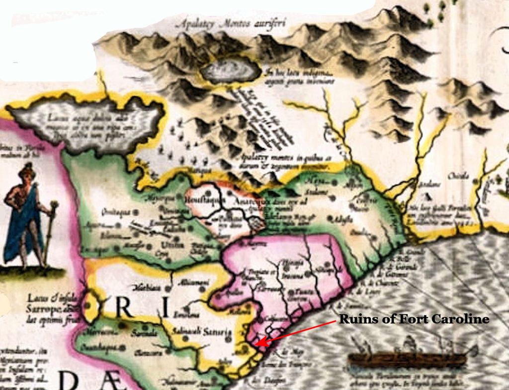
This 1603 map by Jacob Hondius clearly labels the Altamaha River as the May River, shows the ruins of Fort Caroline on the south side of the May River and places the original location of St. Augustine between Sept. 1565 and March 1566 on what is now called St. Andrews Sound in Georgia. No map before the late 20th century located Fort Caroline in Florida.
Ironically, Roger told me that his speech to the National Huguenot Society people ended by giving thanks that such a sacred shrine of American History as the earthen ramparts of Fort Caroline had been preserved by earlier generations in Jacksonville.

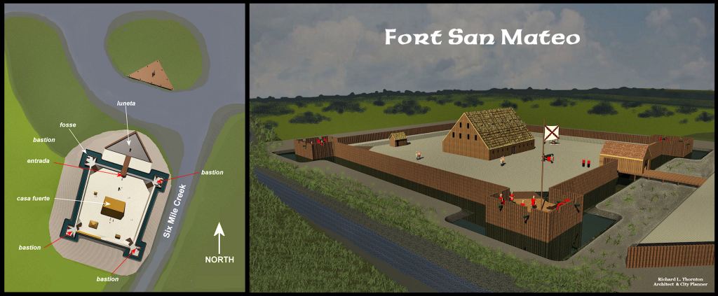
The real Fort Caroline was substantially different than the 1/12th scale replica built by the National Park Service. Foremost is the fact that Fort Caroline was intended to be a fortified town with initially over 1000 residents, not an infantry fort. Even during its construction stages, some officers built houses outside the fortifications.
With the help of a professor, who specializes in archaic French, I carefully translated the detailed description of the structure from the original Late Medieval French text in the memoir of Captain René de Laudonnière then converted its archaic French measurements into the Metric and Imperial measurement systems. A precise computer-based 3D virtual reality program was then utilized to re-create the structure. It was obvious that the real Fort Caroline would not even have fitted on the site in Jacksonville, where generations of tourists were told, the fort was located.
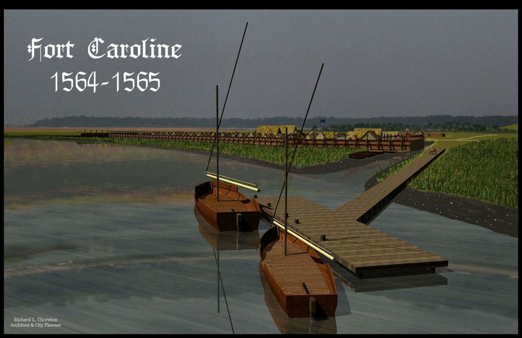
Fort Caroline was built by an all man expedition of about 260 Frenchmen in anticipation of about 900 permanent colonists arriving by the end of the year. Captain René de Laudonnière chose a site on the serpentine South Channel of the mighty Altamaha River that could not be approached by Spain’s massive galleon warships. The water was too shallow for the largest warships. Smaller Spanish galleons would have be towed up stream by rowboats, while never being at an angle where they could fire back at Fort Caroline’s flexible cannons. The ships would have been torn to shreds before ever being able to fire a cannon ball in response.
Another major attraction of this site was a natural artesian spring near this bend in the South Channel of the river, which gushed enough “sweet” water to supply a city. In an earlier voyage along the Atlantic Coast, the French mariners had quickly learned that it is very difficult to find potable water
Members of the Fort Caroline garrison could climb the 85 feet tall ridge, that we now know was created by a tsunami and see any ship sailing along the coast 11 miles away. Of course, that was possible only in the daytime and when it was not raining. However, the Live Oak trees, growing on the islands that ring Altamaha Bay made impossible for any approaching ship to see Fort Caroline.
The fake Fort Caroline is six miles from the ocean. There is no artesian spring gushing water at the site. There are no islands near its mouth nor deep, natural bay behind the islands. The entire St. Johns River Channel, from the Atlantic to downtown Jacksonville is a man-made creation by the US Army Corps of Engineers.

The planners of Fort Caroline did make two fatal mistakes. First, they did not bring along enough food to supply even the original garrison, much less a town of 1200 people. They did not bring fishermen, fishing boats and farmers to feed the colony. By spring of 1565, they devolved into begging or stealing food from neighboring Native American tribes.
Secondly, the fort was very vulnerable to an attack by European armies from the landward side. Perhaps, they only anticipated attacks by Native Americans from that direction, but as can be seen in the architectural rendering above, the south side of the fort only had a relatively low palisade, made of saplings and a ditch.
The terrain sloped gradually upward on the south side of the planned town. Artillery redans could easily be constructed out of range of arquebuses, which would have raked the entire town from above.
Chronology of an archaeological and historical tragedy
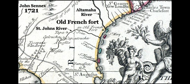
Almost all French, Spanish, Dutch and British maps from 1565 to the mid/late 1700s stated that the May River was the original name of the Altamaha River in Georgia. Most of those maps also specifically noted the location of Fort Carolina on the south side of the mouth of the Altamaha River. Several maps, published in the United States until the 1820s also stated that “May” was the original name of the Altamaha.
1658: In his extremely popular 1658 book, which contained 10 chapters on present-day Georgia, French historian and natural scientist, Charles de Rochefort, specifically stated that Fort Caroline was located on the south side of the May River, 5 leagues (11 miles) from the Ocean and that the source of May River was in the foothills of the Apalachen Mountains. He also stated that several survivors of Fort Caroline had managed to reach the mountains and had intermarried with the Apalachete (Creek) Indians.
In 1776, while staying at a plantation on Broughton Island, GA, William Bartram visited the earthen ruins of a 16th century fort, which his hosts said was built by the French or Spanish. In his famous book, Bartram provided a description of the ruins and how to get there.
1857: George R. Fairbanks moved from Watertown, NY to Fernandina Beach, Florida in 1842 to accept a job appointment from the federal government. He was 22 years old at the time, but shrewdly began buying up undeveloped land around Jacksonville and St. Augustine. By at least 1857, he was espousing his myths of the Fountain of Youth in St. Augustine and the French Huguenots in Jacksonville – both locations being on land that he owned. His lectures evolved into Florida’s first history book in 1868, which stated both myths as facts.

In the 1890s, the Carnegie family, owners of the Dungeness Plantation, found the remains of several survivors of Jean Ribault’s fleet, who were brutally executed by the Spanish behind the sand dunes on the south end of Cumberland Island, Georgia. Artifacts found with the skeletons clearly identified them. The salt saturated sand even preserved some of their clothing. Their remains were reinterred next to a cottage on the estate. Both locations were marked with wooden signs.
The State of Georgia replaced those wooden signs with larger ones in the late 1920s, which told a little more about the sad story of Fort Caroline. The barely legible signs were still there in the summer of 1971, when I was studying Cumberland Island on behalf of Gov. Jimmy Carter and in 1998, when I camped with friends on Cumberland Island for a week. Those signs were removed by the National Park Service around 2001, because they were telling folks that Fort Caroline was about 35 miles to the north.
1925: Construction of the Atlantic Highway from Maine to Miami in the 1910’s and early 1920s was causing tourists to bypass Jacksonville, FL and make St. Augustine their destination. In 1925, the Jacksonville Chamber of Commerce decided to attract tourists off the highway by offering Jacksonville’s French Protestant origins and an alternative to St. Augustine’s Spanish Catholic origins. A favorite spot for locals to picnic and enjoy a panoramic view of the St. Johns River was arbitrarily designated the site of Fort Caroline. Twenty-five acres were purchased and a wooden sign was erected.
In 1933, Georgia Governor Eugene Talmadge wrote a letter to the National Park Service, which nominated Santo Domingo State Park at the mouth of the Altamaha River, as the core of a new national park, honoring Georgia’s Colonial and Native American heritage. The focus of the park were ancient tabby concrete ruins, believed to be the vestige of Mission Santo Domingo de Talasee (Talaxe in Spanish). However, the roughly 3 square mile tract also included the Hofwyl-Broadfield Plantation, ruins of several colonial era plantations, an Indian village site, burial mounds and the earthen ramparts of a “16th or early 17th century French or Spanish fort,” which was visited by explorer William Bartram, mentioned in his famous book and still were visible.
Also, in 1933, Archaeologist Arthur Kelly was hired by the Smithsonian Institute to administer all WPA-funded archaeological digs in Georgia. Civil Engineer, Joe Tamplin, a graduate of Georgia Tech, was hired to be the Supervising Archaeologist for the excavations at Ocmulgee. For most of the 1930s, Arthur Kelly was the only professional archaeologist involved in what became the largest archaeological project ever in North America – Ocmulgee Mounds. However, Dr. Kelly stated that being an intelligent, well-educated man, Tamplen learned quickly and soon functioned as a legitimate archaeologist.
In the spring of 1933, Kelly hired 19-year-old James Ford as his assistant (intern). Ford had dropped out of his Sophomore year Mississippi College earlier that year, due to lack of funds. However, however, Kelly listed his job title as an “archaeologist” in order to get more WPA funds to pay Ford.
1934: Kelly was directed by the Smithsonian to investigate Santo Domingo State Park to determine its true historical value. In 1934, Kelly notified the National Park Service that he was sending one of “his archaeologists” James Ford, to Santo Domingo State Park to carry out an archaeological investigation. The NPS dispatched a film crew to document Ford’s work. That film is available on Youtube.

Frame from NPS film on Santo Domingo State Park
Ford dug numerous test pits along the banks of that part of the Altamaha River. He unearthed numerous bronze and iron weapons and tools, which he credited to the Spanish. They stopped making bronze weapons in Spain around 500 BC!
Between the tabby ruins of the supposed mission was located, westward to the current location of the I-95 bridge, Ford found numerous 16th century French and Spanish artifacts, including weapons, buckles, tools, French china dinnerware and eating utensils. Ford interpreted these as the detritus of a 16th century Spanish army camp, whose existence had been forgotten by history.
Ford stopped digging, when he arrived at the edge of a large trapezoidal earthwork, which he labeled “some sort of Indian mound.” He did not dig there. It is still visible with LIDAR and infrared. The earthworks are the exact size and shape as Fort San Mateo.
Ford correctly interpreted the tabby ruins as being the remnants of 18th century rice and sugar mills, which were burned by Union troops in 1863. However, he had no direct contact with state officials, who continued to assume that the ruins were from the 16th or 17th century.
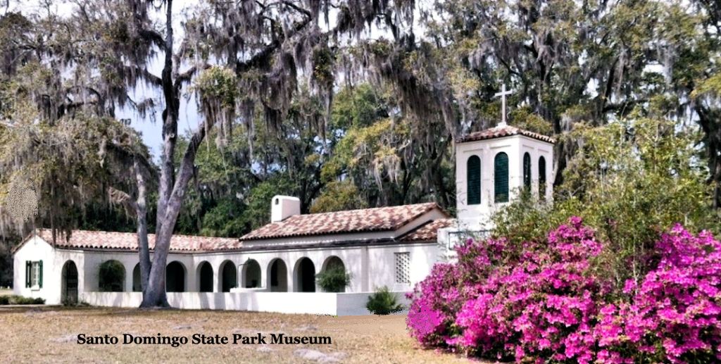
The State of Georgia was elated with the news of Early Colonial artifacts being discovered. Later in 1934, Georgia erected an attractive museum to house the artifacts . . . assuming that the building would speed up the process of the NPS taking possession of the park.
Several years later, Gov. Talmadge received a very condescending letter from the director of the National Park Service, stating that “professional archaeologists from the Smithsonian Institute had determined the site was of no historical value.” Eighteenth century factory walls, 16th century china, Viking swords and Bronze Age weapons sound pretty historical to me?
The State’s leadership was so embarrassed that it closed the beautiful park and converted it into an orphanage during and after World War II. To this date, I still have not been able to determine what happened to Ford’s amazing artifacts, which were on display in the museum.
In 1950, Representative Claude S. Bennett of Jacksonville, submitted a bill before Congress to convert a wooden sign and gravel parking lot on the St. Johns River into Fort Caroline National Monument. The National Park Service balked at the proposal because they could find no artifacts or earthworks to designate as a monument. A compromise bill was passed in 1951, designating it a National Memorial. The City of Jacksonville donated 50 acres to the NPS for said memorial.
In 1961, Rep. Bennett was rewarded for his support of the Kennedy Administration by the construction of a 1/12th scale replica of Fort Caroline and a small museum, so tourists would have something to see.

In 2007, clients at the American Museum of Natural History required me to devour two entire cardboard boxes of photocopied Spanish archives and archaeological reports by AMNH archaeologists, prior to creating architectural drawings of Mission Santa Catalina de Guale on St. Catherines Island near the real location of Fort Caroline. I quickly realized that much of what Florida and Georgia anthropology professors had published in books on the history of the South Atlantic Coastal Plain over the previous 15 years was caco de toro. I started on my quest to discover the real history of the Southeastern United States.
2024: That wooden sign and small gravel parking lot on the St. Johns River has grown into the 46,000-acre National Timucuan Ecological and Historic Preserve. Still today, very few Jacksonville Area residents and out-of-state tourists are aware that the Fort Caroline they visit, is an inaccurate 1/12th scale replica.
Now you know!
