
St. Andrews Sound, Georgia ~ approximately Latitude 31°00′ N and Longitude 81°28’W . . . yes, Georgia! The Spanish Colonial Archives place the original site of the colony approximately 78 miles (125 km) north of where a permanent town was later constructed in St. Johns County, Florida!
by Richard L. Thornton, Architect & City Planner
When I started my journey into the Southeast’s Pre-Columbian and Early Colonial past, exactly 20 years ago this month, I assumed that if a history, anthropology or archaeology book was published at a major university by a respected professor at that university, it was to be assumed to be 100% accurate. Not so! Project after project, I was shocked to discover that over and over again these professors quoted the opinions of authority figures within their profession as facts, rather than going to the trouble to research eyewitness accounts or the colonial archives, as I always do.

The first shock occurred in 2004, when Judge Patrick Moore of the Muscogee-Creek Nation asked me to build an architectural model of Itchesi (actually Itzasi) which is called the Lamar Village Site by academicians. It is located in Ocmulgee National Historical Park about two miles north of the Acropolis.
The National Park Service sent me a copy of its 1973 archaeological report on the Lamar Village Site. Virtually nothing within the Ocmulgee Museum and in books by late 20th century academicians jives with the archaeological report. Itchesi was founded around 990 AD by the same people, who founded Etowah Mounds (Etula) a few years later . . . not around 1250 AD as the museum tells you.
Both towns had Itza Maya names. Both towns were built on horseshoe bends, which were devastated by a catastrophic storm around 1200 AD. Both town sites were turned into islands in the river and covered with up to three feet of muck.
Then in 2005, the Muscogee National Council asked me to build a massive 6 feet by 8 feet model of Etula (Etowah Mounds) at its peak size around 1375 AD. It was to sit under the Great Seal of the Muscogee-Creek Nation in the Mound Building. Dr. Arthur Kelly had given me a copy of the Etowah Mounds Report in the autumn of 1969, while he and Dr. Lewis Larson were leading our Georgia Tech architectural history class on a tour of Etowah Mounds. The previous spring, I had prepared architectural drawings of Kelly’s 9FU14 site on the Chattahoochee River.
I also purchased published copies of Warren K. Moorehead’s report on the 1925 dig at Etowah and Cyrus Thomas’s 1885 dig at Etowah. In addition, MCN Principal Chief A. D. Ellis arranged for the US Geological Survey to provide me with several infrared scans of the Etowah Archaeological Zone.
I quickly discovered that the team of University of Georgia professors, who guided the mid-1990s remodeling of the Etowah Museum had not only “dumbed down” the cultural level at Etowah, but also produced a fraudulent portrayal of the discovery of the famous two marble statues in the museum’s key exhibit. The statues were discovered in a collapsed tomb underneath Mound C within a circular temple and next to a stone masonry, rectangular building.
The people of Etula wore woven cloth garments, with colorful dyed patterns, like those described by the De Soto Expedition, when it traveled through Georgia in 1540. Their pottery was fired in dome-shaped stone kilns to high temperatures. They made extensive use of copper and natural brass tools, weapons and ornaments. They fought with brass hatchets and brass tipped arrows. They wore leather helmets with copper crests. They carried rectangular shields into battle, which strongly resembled those used by Roman legionnaires. Well, you get the gist.
The Archives of the West Indies in Seville, Spain
As mentioned in an earlier article of this series, in 2007, the American Museum of Natural History required me to study two cardboard boxes of archaeological reports and photocopied Spanish archives from Seville, Spain, prior to preparing architectural drawings of Mission Santa Catalina de Guala on St. Catherines Island, GA. I quickly realized that the Early Colonial History in my high school and college textbooks – plus popular late 20th century anthropology books by Florida professors – contained very inaccurate information about the native peoples of the South Atlantic Coast and the early colonization of the region by the Spanish. Even contemporary websites by the National Park Service contain some very inaccurate details.

In doing research for my book on Fort Caroline, I found numerous examples of where Florida academicians had intentionally mistranslated Spanish archives . . . changing the latitudes and distances so that the St. Johns River would seem to be the location of Fort Caroline and contemporary St. Augustine, FL the location of the original St. Augustine. In some cases, they merely redacted any sentences in letters from Pedro Menendez to the King of Spain, which conflicted with the fake location of Fort Caroline or the real location of the first St. Augustine.
The critical information comes from the reports prepared by Pedro Menéndez de Avilés, commander of the expedition to destroy Fort Caroline and later governor of La Florida. They were sent directly to King Filipe II. Menendez would not have dared to send false information to the king.
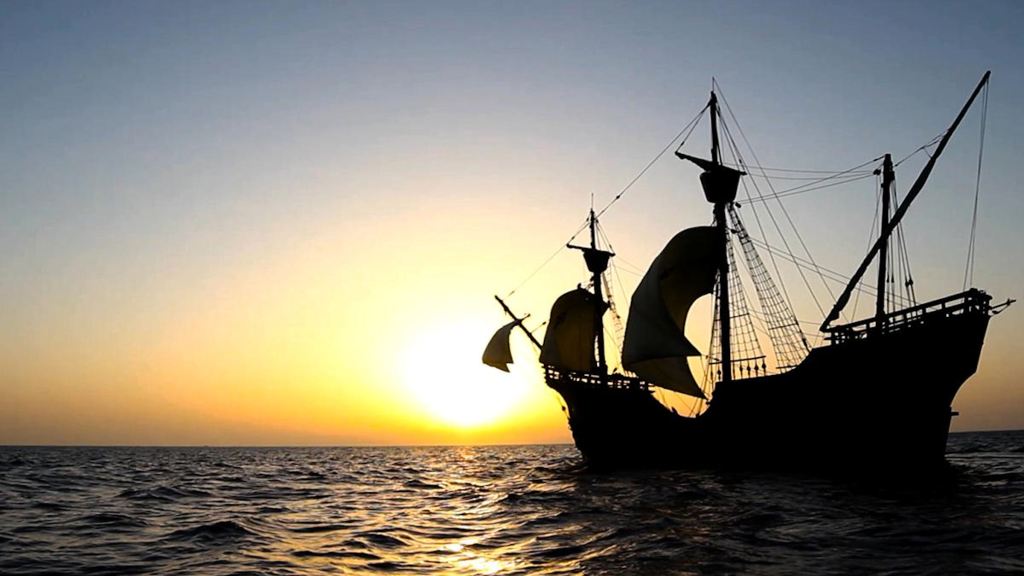
His fleet containing approximately 1,000 soldiers, sailors and colonists . . . plus a menagerie of farm animals . . . first caught site of the Florida Coast near Cape Canaveral then sailed northward. They noted what is now St. Augustine Bay as a good location for a “Coast Guard station” to help Spanish treasure ships in distress, but actually landed at Amelia Island, Florida.
They officially landed on the Roman Catholic feast day of Saint Augustine – which is August 28, 1565 in the Gregorian calendar. The first “Thanksgiving Mass and Feast” was on Amelia Island, not at St. Augustine. Afterward the Spaniards gathered fresh drinking water and intelligence on the French from local Natives.
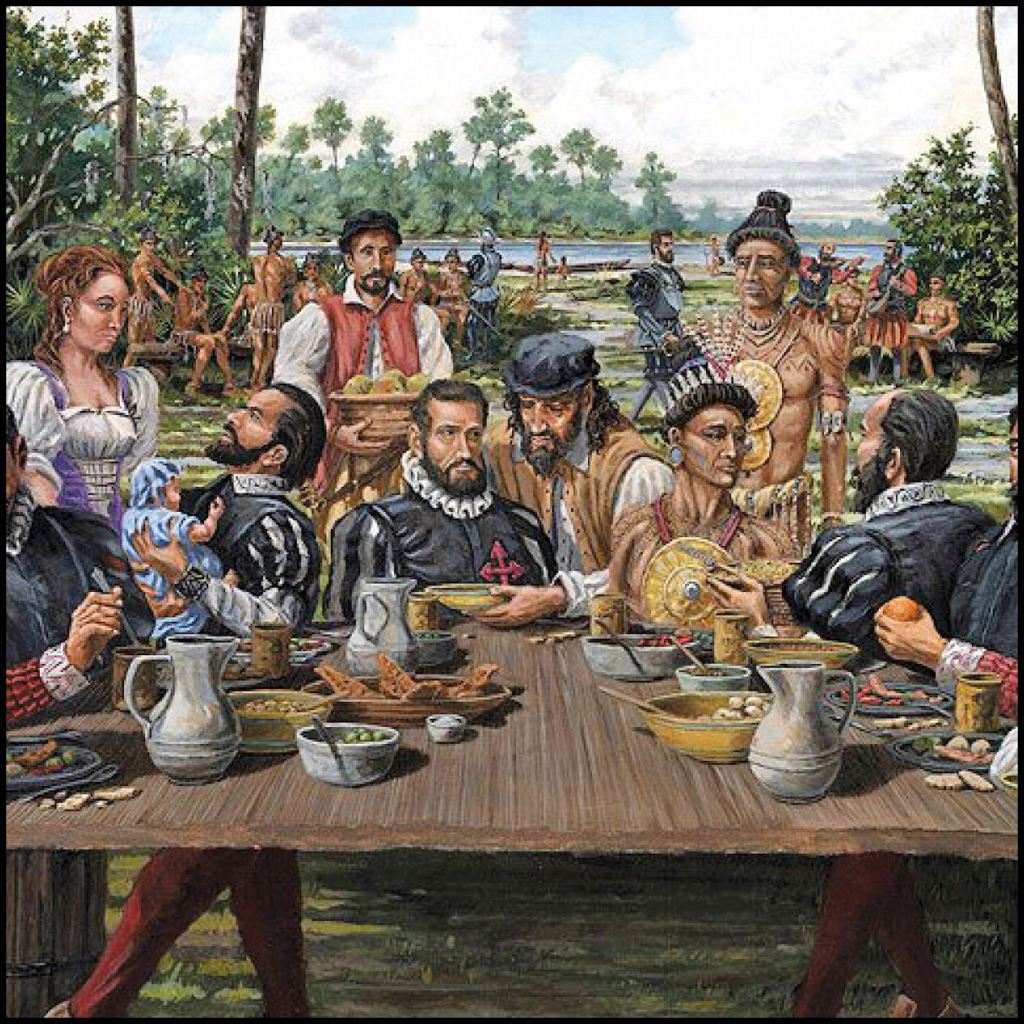
St. Augustine, FL now claims to be the location of the first celebration of “Thanksgiving” in North America. This artist’s conception shows Native Americans fraternizing and eating with the Spanish. That was highly improbable and not mentioned in the report by Pedro Menendez. Furthermore, his report to the king states that they sailed past what is now St. Augustine Bay and landed farther north on Amelia Island, FL – north of Jacksonville. Menendez’s large flagship could not enter St. Augustine Bay.
Menendez wrote that the mouth of the Rio Secco (Spanish name for the Altamaha River) was about 31.5 degrees latitude. He could see a large French fleet, but could not see Fort Caroline. Thinking themselves out numbered and out-gunned, the Spanish sailed southward about 35 miles then turned into a large bay with a deep harbor, when they saw a large storm (probably a hurricane) overtaking them. He stated that the harbor was large enough to protect an entire Spanish treasure fleet from storms. It was called the Bay of Dolphins by the French.
St. Andrews Sound is the deepest natural harbor on the North American Atlantic Coast. This was one of the reasons that the United States Navy constructed the Kings Bay nuclear submarine base in an estuary off of St. Andrews Sound.
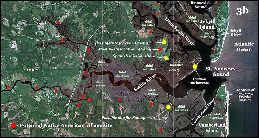
The mouth of this bay was at about 31 degrees latitude. The mouth of St. Augustine Bay is 29.9 degrees latitude. The entrance was bounded by San Pedro Island (Cumberland Island, GA) and Aseo Island (Jekyll Island, GA). Two rivers flowed into the bay that created a peninsula, jutting out into the bay. No such peninsula exists in St. Augustine Bay.
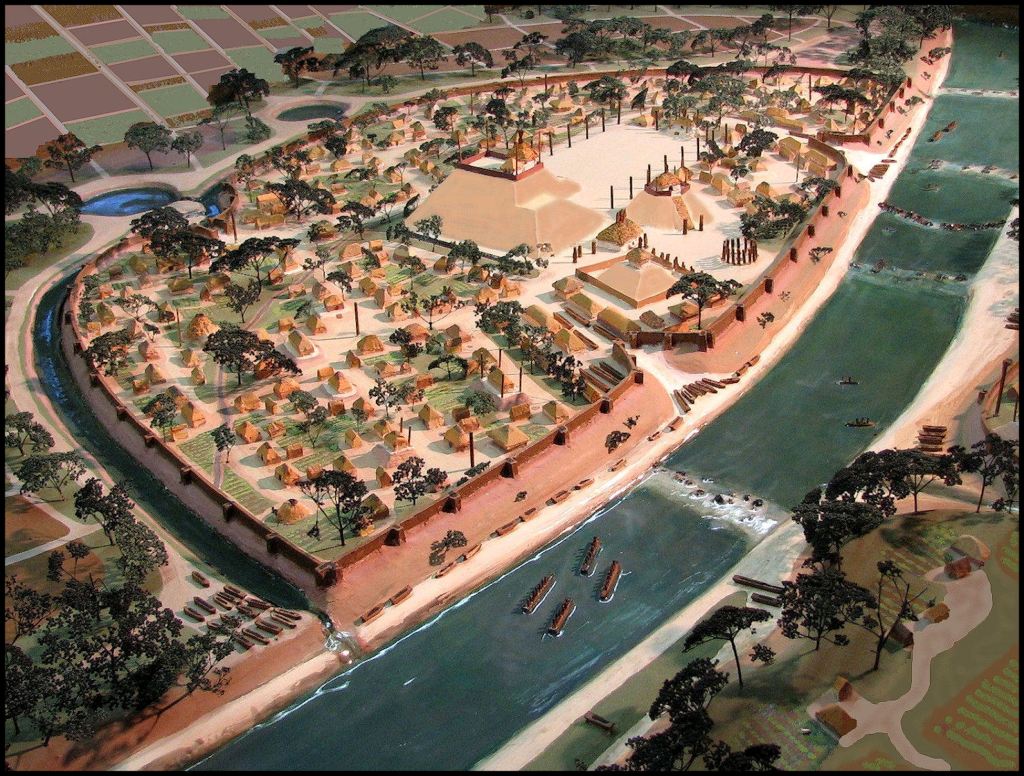
Menendez unloaded the civilians, some soldiers and livestock near the planned location of his first colony, which was fairly close to the Satile Indian village of Seloy. They decided to name the town after St. Augustine, since his feast day was when they first landed in the New World.
The warships then sailed northward and anchored near another Satile village at the latitude of the north side of the Brunswick River. They took over the village chief’s house and built a fort around it. Apparently, some young Satile women were ravaged by Spanish soldiers. It was at this point that the Satile really began to hate the Spanish.
The Satile were a Georgia tribe. The Satilla River gets its name from them. Florida academicians call them the Satiruriwa . . . but actually that is the name of their king. Sati Uriwa means “Colonists – King” in the Panoan language of Peru. Most of the Native peoples on the Georgia coast were of South American or Caribbean origin. They were not “Creek Indians,” but remnants did later move westward and join the Creek Confederacy.
There was a Satipo province in Georgia and still is a Satipo province in Peru. There was also a Satile village in the county, where I currently live that was named Saticora . . . called Seticoa by European settlers.
The small Spanish army marched northward over the length of Glynn County, GA and attacked the south side of Fort Caroline, where the palisade had been intentionally demolished by the French . . . in preparation for sailing back to France. The French colonists were massacred. Those Protestants, who surrendered were hung from nearby trees.

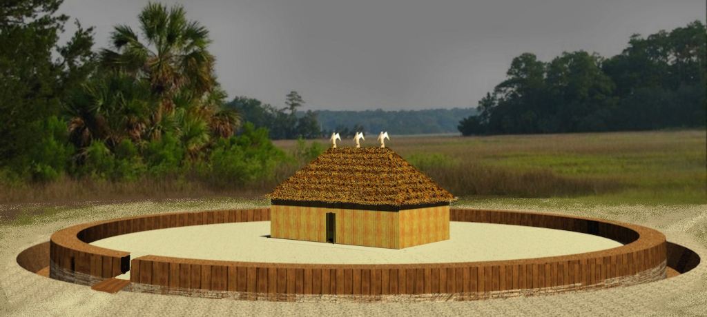
Menendez then returned to the civilians in what is now St. Andrews Sound. He gave instructions to the engineers and soldiers on the construction of a fort for the new town of St. Augustine. This is probably what it looked like. Apparently, the civilians constructed crude farmsteads outside the wall of the fort to house their families and the 200+ farm animals brought by the ships.
Menendez heard from Native American informants that most of Jean Ribault’s fleet had been destroyed by the hurricane or tropical storm, but that bands of survivors had made it to shore. They were now wandering along the beaches to the south. His large galleon led a group of warships southward to construct a small fort at the mouth of what is now St. Augustine Bay, Florida.
Here is well-documented proof that the first St. Augustine was not in Florida. The flagship, commanded by Menendez was too large to enter the mouth of what is now St. Augustine Bay. He then gave instructions to his sub-commander and returned to the St. Augustine Colony. His flagship easily passed through the deep channel between Jekyll Island and Cumberland Island. Once the fort was near completion, Menendez returned to Spain.
A large party of survivors, led by Jean Ribault, surrendered without a fight to a smaller party of Spanish soldiers near what is now called the Matanzas River, south of St. Augustine, FL. As unarmed castaways, who had never actually been in combat with the Spanish, they expected to be treated decently . . . fed . . . then ransomed back to France. Instead, all of the Protestants (which was most of the party) were brutally put the sword.
While Menendez was traversing the Atlantic and visiting Spain, things went very badly for the colonists at the first St. Augustine. They were greatly out-numbered by the Satile, who hated the Spanish with a passion. Any Spaniard who ventured away from the fort to get firewood or potable water was very likely to be killed. Many of the colonists became ill from contaminated water or food.
The colonists and soldiers mutinied in late February and began preparations to sail back to Spain. Menendez returned to the mayhem in early March. Rather than brutally crushing the rebellion, he agreed with colonists that they had landed in a very bad spot, that probably would result eventually in most of them being dead.
Menendez ordered the fort dismantled and as much as possible, transported to the bay 78 miles to the south, where the “Coast Guard station” had been built. Here the landscape was thinly populated by much more primitive Native American bands, who would not be a serious military threat to the Spanish.
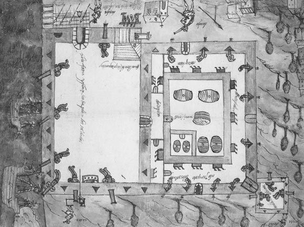
Original fort at St. Augustine, Florida . . . from the Spanish Archives of the West Indies.
During the next 35 years hundreds of Spanish soldiers, sailors and priests met violent deaths on what is now the Georgia Coast, before it was sufficiently pacified to establish a Franciscan mission system, with its headquarters on Isla Santa Catalina.

Your blog is always a cliffhanger and we can hardly wait for the next episode! Thanks for sharing all of your experiences and knowledge here with us Richard! I think its interesting that the water running by Bonaventure Cemetery at times mapped as “St. Augustine Creek” which reminds of their presence across Georgia and these areas.
LikeLiked by 1 person
Early Georgia colonists were definitely aware that Fort Caroline was on the Altamaha River and the later construction of many Spanish missions on the Georgia coast and southern tip of South Carolina, but I have never run across any English language colonial document mentioning this. However, the Spanish documents sure remembered both the early St. Augustine, Santa Elena in South Carolina and contemporary Fort San Mateo. It was the basis of them claiming all of what is now Georgia and South Carolina.
LikeLiked by 1 person
It reminds me of what Phinizy Spalding spoke of when referring to Georgia as “the most unpioneered of the original 13 Colonies.” So much lost, destroyed, hidden, yet to be discovered. It was the joy of my researcher youth here in Savannah and The Land of Allyon. Your St. Augustine subject prompted the memory of prisoner swapping parties that the English in Georgia and the Spanish shared in and wonder what those exchanges really looked like.
LikeLiked by 2 people
Maybe the sandbar at Memphis, TN in the Arkansas river was also of same fate! There is also a museum there now
LikeLiked by 1 person