
How we discovered Colonial Era history that had been completely overlooked by university academicians!
by Richard L. Thornton, Architect & City Planner
All illustrations in this article are ARCHITECTURAL graphics, created with BricsCad from Brussells, Belgium and Artlantis from Studio Base2 in Paris, France.
There is absolutely no excuse for historians and anthropologists, particularly those in Georgia, omitting the discussion of 17th century colonization in the Southern Appalachian Mountains. The late 18th century discovery of long-and-currently occupied Sephardic villages in SW Virginia and NE Tennessee, plus the discovery in the Georgia Gold Fields of 17th century European village ruins and artifacts were mentioned in several 19th century books, most of which are either still in print or available on-line today.

The official United States Congress map of the Georgia Gold Belt mentions the Spanish miners and displays a drawing of a 17th century European gold-refining retort, found in the Nacoochee Valley.

Dr. Brent Kennedy in the Shenandoah Valley of Virginia in 1992
The discovery of French, Middle Eastern and Iberian DNA in Appalachia
Dr. N. Brent Kennedy became a national celebrity between 1995 and 2005, because of his pioneering work in the genetic, linguistic and genealogical heritage of Southern Appalachian families. His first book in 1995, The Melungeons . . . Resurrection of a Proud People became a national best seller. In the book, Brent theorized that refugees from Europe and Turkish galley slaves, freed by the Spanish and English, had settled in the Appalachians in the 1500s and 1600s.
As the science of genetics advanced rapidly in that period, Brent was able to identify substantial Middle Eastern, Iberian and North African DNA in both the old time “Melungeon” families of Southern Appalachian families and the Cherokee People. The typical federally-recognized Cherokee today has twice as many Middle Eastern DNA test markers as the average practicing Jew in the United States . . . and very little or no AmerIndian DNA!
He also discovered many Anatolian words in the Cherokee language. Almost all the Cherokee words having to do with female familial relationships were Anatolian words! The famous 18th century Cherokee chief, Attakullakulla had an Anatolian name, which means “Red Horse.” His name had no meaning in the modern Cherokee language.
It was Brent, who first showed me the real Sequoyah Syllabary. It looks nothing like what Cherokees today call the Sequoyah Syllabary, but has identical symbols to those in the alphabet of the Medieval Script used by Christians in Eastern Anatolia and the Caucasus Region.
Sequoyah probably never if saw the current Cherokee syllabary, because it was created by Cherokee Principal Chief Charles Hicks and white missionary Samuel Worcester in 1826, after Sequoyah moved out west. Worcester continued to modify his original design until his death in 1859. Actually, the “Sequoyah” Syllabary was called the “Hicks” Syllabary until North Carolina tourism development officials changed the name in the 1970s.
Brent and I first met in 1990, after a TV station in southwest Virginia broadcast a special feature on my goat cheese creamery and the naming of my Colonial farmhouse as the national residential restoration of the year. While we were munching on goat cheese and discussing Virginia history, Katie Couric and her first husband, Jay Monahan, casually drove up and asked to walk around the farm with her friends from NBC News. That snowed the heck out of Brent! LOL He would always stop by our farm on his way to do research at the Library of Congress. There was NO internet back then!
Brent tracked me down in 2000, when I was living in Jasper, GA. He had found ancient ruins of European style houses in East Tennessee and western North Carolina, which he thought might date to the 1600s. He was right.
Brent, Susan Karlson and I would explore the mountains together from time to time. Brent repeatedly joked that we had known each other Biblically for over a decade. It was time for us to get married and move back to the Shenandoah Valley, where we met. Brent didn’t know that Susan now had a top secret “James Bond” job and that I didn’t even know her real name!
Sadly, Brent was disabled by a stroke in 2005. He never spoke again and I never saw him again. He died in 2020.
The discovery of 16th and 17th century artifacts in Appalachia

As mentioned in an earlier article, the famous 20th century archaeologist, Robert Wauchope, wrote in Archaeological Survey of Northern Georgia that he could have filled a tractor trailer with the 16th and 17th century artifacts that he unearthed in the Nacoochee Valley, plus such artifacts in private family collections.
Very few, if any museum exhibits show Southeastern Native Americans riding horses in the 1700s or even Europeans riding horses in the 1600s, but that is a fact. Wauchope unearthed extensive evidence of both imported firearms, plus locally forged tools, horse shoes and horse bridle linkages in what archaeologists label the “Late Lamar Period” strata in the Nacoochee Valley. Virtually all the artifacts unearthed after the 1700 AD strata were imported from European fabricators or home-made European style metalcraft.

A metal smith at the Spanish trading post. Artifacts unearthed or examined by Robert Wauchope suggest that metal smiths in the Upper Chattahoochee Valley knew how to forge or repair iron, steel, bronze and copper items.
Discovery of forgotten eyewitness accounts
In late spring of in 2013, I was contacted by a linguist and expert on the “Renaissance in southern Europe” from Boston University. Marilyn Rae, telephoned me about a French language book that she had stumbled upon in the “Fantasy and Utopia” bin of the John Carter Brown Library at Brown University.
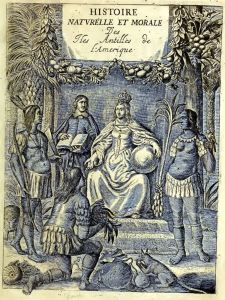
First published by the Rev. Charles de Rochefort in 1658, L’Histoire Naturelle et Morale des isles Antilles de l’Amérique contains ten chapters on what is now northern Georgia and western North Carolina. The news was astonishing because late 20th century university professors in Dixie had unanimously told us that almost nothing was known about the interior of the Southeast during the 1600s.
The detailed information was obtained from Richard Brigstock, who had lived in that region during much of 1653. Brigstock was a cousin of Edward Bland, who was a investment partner with the Spanish Governor of Florida in the 1646 construction of a road from St. Augustine to the Nacoochee Valley, plus the construction of fortified trading post there. Brigstock was based at the village of Cho’i-te, which is now Alpine Helen, GA.
The book had been placed in the Fantasy and Utopia bin, after being reviewed by history professors in 1904. It was last checked out in 1921. The reason for this “book banning” were the ten chapters on Georgia. They described an advanced Native American civilization in the state, almost on par with Mexico, which built earthen pyramids and stone buildings, plus wove elaborate clothing. The professors reasoned that since it was well known that white Southerners had inferior minds, plus were backward and lazy, undoubtedly the Indians, who came before them were the same. (Yes, really!)
There is another bit of irony here. Marilyn Rae was still living in the northern Shenandoah Valley, when I lived there in the late 20th century. In fact, her home was quite close to the Wendy’s Restaurant, where FBI agent Susan Karlson and I first met and rendezvoused often. Marilyn’s and my paths probably crossed, but we don’t remember the occasions.
Brigstock’s description of the indigenous peoples in Georgia contained detailed accounts of their architecture. Much of what he told Charles de Rochefort was not discovered by Southeastern archaeologists until the late 20th century. Yet, other things that Brigstock described . . . like the large European mining colony, Roman Catholic Mission and the Spanish trading post compound seemed far-fetched. They were not mentioned in any contemporary archaeology or history book. It would take me ten years and the use of LIDAR to find all of the structures, described by Brigstock to Charles de Rochefort.

Misidentified French Protestant crosses!
Numerous silver crosses have been unearthed by archaeologists in northern Georgia, which the finders uniformly misidentified as being “proof that De Soto visited here.” Not so.
The crosses distributed by the De Soto and Pardo Expeditions were mass-produced in Mexico and quite different. Some of them have also been found . . . primarily near the coast and border with Florida. They are simple silver crosses on which the caricatures of crude animals have been etched.
To this day French Protestant girls and women wear a cross very similar to the ones above that was found near the Coosawattee River. The key elements of the Protestant cross are a rose in the center, plus roses or rays of sunlight on the points of the cross. Many also have flame on the lower point, symbolizing the Holy Spirit.
I learned this fact the good ole fashion way . . . by falling instantly in love with architecture student Yvette De Veaux in Oaxaca, Mexico, while on my fellowship in Mexico. Yvette was a French Huguenot from a small village in Languedoc (SE France). She wore one of those crosses. Twenty years later, Vivi the Courtesan purchased a fancier version of this cross with jewels, upon returning to France, after I baptized her in my Shenandoah Valley farmhouse on December 19, 1990.
There are ancient silver mines a short distance north of the Coosawattee River. My guess is that these somewhat cruder versions of the Huguenot girl’s cross were made locally.
Covert trade with Santa Elena
From 1567 until 1584, a clandestine trade existed between the Apalachete and the small Santa Elena Colony on Parris Island. SC. Mellilot was probably the location where the trade between Apalachete gold and gems with Spanish weapons, cloth and cooking ware occurred. Any Spaniards, who proceeded further into the heart of the Apalache Nation without permission, were killed on site.
A few favored traders were allowed to continue their journey to a large town on the side of a mountain, which the Spanish called Copal Grande (Great Copal) and archaeologists label the Track Rock Terrace Complex. Here they traded European goods for diamonds and rubies. One of those diamonds was purchased by the Governor of Florida for 5000 crowns or about $400,000 today.
Santa Elena was abandoned in 1584 due to chronic attacks by South Carolina’s indigenous peoples. The Spanish then concentrated their colonization efforts in present-day southeastern Georgia and northeastern Florida
Establishment of the Kingdom of Apalache
Something not fully explained happened elsewhere. The capital of the Kaushete (Coosa) on the Coosawattee River was abandoned, while the Apalachete elite took over Etula (Etowah Mounds) and constructed their large round houses on the plazas of the former Kusate town. This town, along with most of the large Creek towns in North Georgia were permanently abandoned after the catastrophic 1696 Smallpox Epidemic. Afterward, the members of the Creek Confederacy limited the size of their communities to about 500 people.
This fourth occupation of Etowah Mounds was presented in the original Etowah Mounds Museum, which was designed by one of my former professors at Georgia Tech, Julian Harris. When my Architectural History class was given a tour of Etowah Mounds in Fall 1969 by Drs. Arthur Kelly and Lewis Larson, the fifty feet (15 m) diameter house footprints were even visible in the coloration of the grass. Today, they are only visible with infrared imagery. We were also handed a copy of the Etowah Mounds Archaeological Report. I still have it. However, since 1995 the public has been told that the report was never published. Here is why.
During the early 1990s, remodeling of the Etowah Mounds Museum was guided by a team of University of Georgia archaeology professors, who “erased” the fourth occupation of Etowah. They created the bald-faced lie that the famous marble statues were found in a shallow pit ON TOP of Mound C. Henceforth, visitors were told that the statues were hastily buried as the Cherokees were about to capture Etowah in 1585. Several of these professors were also on the payroll of the Eastern Band of Cherokees, who wanted to build a gambling casino near Etowah Mounds.
In fact, the concealed archaeological report describes the marble statues being excavated in a collapsed temple UNDERNEATH Mound C. The construction of the temple was radiocarbon dated to around 1000 AD.
The Etowah Mounds museum was reopened about the same time (June 1995) that I gave up trying to return to my beloved Shenandoah Valley farm and so rented a townhouse near Etowah Mounds. The museum staff freaked out when I showed them the photographs in the archaeological report. The State of Georgia had just spent about $180,000 on a diorama, which portrayed the bald-faced lie. Several of those UGA professors were also behind the extreme opposition to the “Mayas in Georgia” Thing in 2012.
In 2006, the archaeological firm carrying out a remote sensing survey of Etowah Mounds posted aerial photos of the 1955-1956 excavations at Etowah Mounds . . . including the excavation of the “erased” fourth occupation between 1585 and 1700 AD. I immediately recognized the proof of the fourth occupation and wrote about it in one of the earliest “People of One Fire” newsletters. I could not download the HTML file photos, because the MS Windows technology had not been developed yet.
The photos of the “erased” Apalachete buildings were immediately yanked from the internet. I asked to see and copy the original photos at the University of West Georgia Department of Anthropology, but was refused access. However, the US Geological Survey did give me graytone infrared images, which showed the building footprints.
The Apalachen Foreign Legion
In the mid-1980s a team of North Carolina geologists dated the supporting timbers of ancient gold and silver mines in western North Carolina and northern Georgia. The dates of the trees, cut by metal saws and axes ran from around 1585 to 1620. The Sephardic wedding memorial that I found carved on boulder on Hoopers Bald Mountain in North Carolina announces its date as September 15, 1615. Evidently, this period corresponds to a massive influx of Sephardic Jews into the Southern Appalachians. Rabbis in the Netherlands and France began preaching about a New Israel and New Jerusalem in Florida . . . a term then used to label all of what is now the Southeastern United States.
The King of Apalache told Richard Brigstock in 1653 that an earlier king had allowed many Europeans to settle on the recently conquered northern and southern frontiers of the Kingdom of Apalache as protection against northern Indian tribes and Spanish invaders from the south.
Evidently, the leaders of Apalache utilized a battalion of French Protestants and Sephardic Jews, carrying fire arms and steel weapons, to conquer a vast territory from present-day southwestern Virginia to southwestern Georgia. Archaeologists call this territory, “The Late Lamar Culture.” LOL The mercenaries were awarded large tracts to start colonies for their kinsmen. Most of the men were single and so also took Native American wives. Their mestizo offspring became distinct tribes and ethnic communities.
100 mysterious horsemen
Beginning in 1600 AD, Spanish Governor Gonzalo Méndez de Canço y Donlebún received repeated reports from Native American vassals in southern Georgia that a group of about 100 European horsemen were patrolling the Fall Line in what is now Middle Georgia – between the Savannah River and the Chattahoochee River. Méndez speculated that the horsemen were Englishmen from the Roanoke Colony, which the Spanish Navy could never locate. An missionizing expedition into the interior of Georgia in 1597 had been warned at the capital town of Tama, near the Fall Line then told at Ocute that they would be killed immediately if they attempted .
In 1602, Ensign Juan de Lara led a troop of soldiers along with Guale men to Tama again. They were again warned at Ocute not continue northward, but were more heavily armed this time and so ignored the threats. De Lara was told that the locals HAD seen “some” Spaniards on horseback with lances, who arrived from the north. De Lara thought that they had seen Englishmen, but it is likely that the indigenous people had seen Sephardic members of the Apalachen Foreign Legion.
De Lara was surprised to see Spanish vegetables and fruits thriving in the gardens along the Altamaha and Oconee Rivers along with Indigenous American plants. He also observed peach orchards, obviously planted with seeds from typical Andalusian peach varieties. The Eurasian fruits included several types of melons.
Spain wanted to found a town with Iberian immigrants farther north in what is now Georgia. The rumors of Spanish-speaking cavalrymen, who were hostile to Spain continued. Between 1624 and 1627, Governor Don Luis de Rojas launched two small military expeditions into the interior of present-day Georgia. The names of the participants and their destinations do not survive.
During 1627 and 1628, a military expedition consisting of Ensign Pedro de Torres, a squad of Spanish soldiers and a group of Florida Indian allies, traveled through the Coastal Plain and southern Piedmont in search of the mountains where gold was plentiful.
Developing commerce with Indigenous peoples.
While the total population of the British North American colonies had grown to around 50,000 by the mid-17th century, Spanish Florida’s European population had stagnated at around 600 people. England, France or Sweden could have easily grabbed the colony, if they wanted it. Much of the Spanish Empire in the Americas was under-populated, so there was little probability of settlers being available to settle additional lands stolen from the indigenous tribes. Anywhere the Spanish placed Roman Catholic missions to control the indigenous people, the local population rapidly sped toward extinction.
Benito Ruíz de Salazar Vallecilla was appointed Royal Governor of La Florida on April 10, 1645.] In that year he led an expedition along the Lower Chattahoochee River into southwestern Georgia and eastern Alabama. His soldiers attacked and burned several Apalachicola towns near present day, Columbus, GA, that objected to the presence of Spanish soldiers and missionaries. Ruíz established short-lived Mission San Miguel de Asile. He developed a farm near the mission that raised wheat, maize and hogs.
In 1646, Ruiz ordered construction of a pack mule road from St. Augustine to the headwaters of the Chattahoochee River, one kilometer north of the present city of Helen, GA. In conjunction with English merchant, Edward Bland, he built a fortified trading post, a small fort and a mule-breeding farm. The Roman Catholic Church established a small mission next to the trading post.
Governor Ruiz died during a plague in 1651, but in 1653 a cousin of Edward Bland, Richard Brigstock, stayed for much of the year in the “international” town of Cho’i-te, immediately south of the Spanish compound. Brigstock frequently socialized with the friar at the mission and the administrators of the trading post. His sketches described the compound as being quite extensive.
1660 – Letter from Mellilot
A letter was written to De Rochefort in French, from Edward Davis, a director of Mellilot, which was dated January 6, 1660. It describes a forgotten European colony that longs for direct commercial contact with Europe. That would occur a decade later with the founding of Charleston . . . but would also open a pandora’s box of pathogens, for which the colonists had lost immunity.

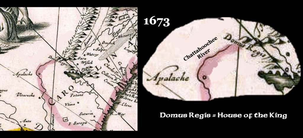
1669 – Johann Lederer Expedition
This recent arrival from Germany led a small expedition along the eastern slopes of the Blue Ridge Mountains from the Shenandoah Valley to somewhere in northern South Carolina. He might have gotten as far as NE Georgia, because his map states “House of the King” where the Nacoochee Valley and Apalache Capital was located. His map also shows a man-made dam near the conjunction of what is now South Carolina, North Carolina and Georgia. Settlement of the Province of Carolina has just begun and Georgia didn’t exist.
Lederer’s book did not mention the Cherokee. He stated that the Rickohockens controlled the southern Virginia Mountains and northern North Carolina Mountains. The Wataree (aka Wataugi/Watauga) occupied the central North Carolina Mountains. The Apalache controlled what is now western North Carolina and northern Georgia.
1673-1674 – James Needham and Gabriel Arthur Expedition
Needham and his bond servant Gabriel Arthur were dispatched by Abraham Wood to establish trade between Tidewater Virginia and a tribe that Virginians called the Tomohitans. Its real name was Tamahiti, which is an Itza Maya word meaning “Merchant People.” They originated near the Forks of the Altamaha River in central Georgia, but spread northward all the way to Virginia. In southwestern Virginia they encountered the Oconechee, which was another Creek tribe, which was an offspring of the Oconee in NE Georgia. Apparently, the men were trying to reach the Tennessee River, which they called the Tomohitan River.
While in what in Virginia and what is now North Carolina and Tennessee, the two men encountered Spanish-speaking traders on several occasions. Apparently, they were based at the trading post in the Naccoochee Valley of NE Georgia.
Needham was captured and killed by Oconechee. Gabriel Arthur’s written description of the expedition never mentions the word, “Cherokee.” The last leg of his adventure involved walking from the western North Carolina Mountains to the new settlement of Charlestown on the Atlantic Coast. He stated that throughout the journey, the Natives spoke dialects of the Creek languages.
There is a fraudulent version of Arthur’s report, which deleted references to Spanish traders and substituted the word “Cherokee” for the names of Creek tribes. It was created in 1991 by a history professor at the University of North Carolina at Chapel Hill. It is frequently quoted by “Cherokee History” books and websites.
1673-1700 – Robert Morden’s maps of the British North American colonies
Morden’s early maps labeled all of the Southern Appalachians as being within the territory of the Apalache or Apalachen. The Nacoochee Valley was labeled, “House of the King.” The final form of his maps in 1693 and 1700 merely showed the town of Apalache located where the village of Sautee, GA is now located. No map, drawn by Morden, ever mentioned the word, “Cherokee” or any word similar.

Detail of the Franquelin Map
1684 – Map of North America by Jean Baptiste Franquelin
This astonishingly detailed map of the interior of eastern North America was based on information from French traders and Marines, who explored the major rivers and trade paths. It provides names of all the major Native American towns and tribes in eastern Tennessee and northeast Georgia, plus the location of the trading post and mission at the headwaters of the Chattahoochee River.
The word, “Cherokee” is not seen anywhere on the map. All town names in what is now eastern Tennessee, Georgia and western Carolina are either Creek, southern Mesoamerican, Panoan (Peru) or Arawak words.
1693 – James Moore expedition to the Nacoochee Valley
Moore led a troop of mounted Redcoats and Indian scouts to explore what is now Northeast Georgia. The original colonial archive merely states “Indians” from villages that had Creek names. Modern authors changed “Indians” to “Cherokees.”
While cresting a ridge on the eastern edge of the Nacoochee Valley, the party observed numerous smoke plumes. Their scouts explained that these plumes were from gold smelters, being operated by Spanish gold miners. Realizing that they were greatly outnumbered, the Carolinians made a hasty retreat. South Carolina did no exist at this time.
1700-1776 – British Colonial Era
At the time of contact with English settlers from South Carolina, the Bohurons lived in the Blue Ridge Foothills, immediately south of the Nacoochee Valley – between the headwaters of the Oconee River and the Chattahoochee River. Their province composed present day (southern) White, Banks, Madison and (northern) Hall Counties. Chickasaw villages occupied the same region, but they were allies and both members of the Creek Confederacy.
The policy of allowing European and African immigrants, who married Native spouses was continued throughout the 1600s for Jewish and Protestant refugees from the Old World, who wished to settle in Apalache realm. Many became gold or gem miners. He wanted their technology and commerce, but also their loyalty. He dispersed the refugees amongst its towns. This probably explains the presence of the ruins of Late Medieval style houses at several terrace complexes in North Georgia.
Within a generation or so there was a large number of mixed-blood people in Apalache, which gave the kingdom a technological edge on the battlefield and in diplomatic conferences. However, tight political control of that original vast area had withered after the Paracusa (High King) had converted to Protestant Christianity in the 1570s.
The catastrophic Smallpox Plague of 1696, plus the Native America slave raids dispatched from Virginia and coastal Carolina, caused the kingdom to suddenly disappear . . . leaving only its name to the Appalachian Mountains and the Apalachee River in northeast Georgia. Apalachen is the plural of Apalache in the Panoan (Peru) and Creek languages.
1754 – End of the Creek-Cherokee War
The Bohurons seemed to have played a major role in the catastrophic defeat of the entire Cherokee Nation by the Coweta Creeks in the autumn of 1754. It seems implausible that the soldiers from a single Creek town on the Chattahoochee River, where Columbus is today, could defeat the entire Cherokee Nation, but this actually happened and was recorded in the archives of the British provinces of Georgia and South Carolina. British officials were terrified because Great Britain was at war with France and the Cherokees had promised to send warriors . . . whereas the Creeks and Chickasaws had stated that they would only fight their French friends, if French soldiers invaded their territories.
All the historic markers, books and Chamber of Commerce brochures, which describe a great victory by the Cherokees, where they captured all of northern Georgia, are pure hogwash. It never happened and there was never any Battle of Taliwa. In fact, in the surrender treaty that the Cherokees signed in December 15, 1754, the ceded back to the Creeks all lands that they had occupied since 1715 . . . including a section of North Carolina!
The Cherokee villages on their southern border were erased so quickly in the fall of 1754 that they didn’t have time to send out runners to warn other Cherokee bands. Coweta’s army was deep inside North Carolina before any Cherokees knew they were there. As stated in John Mitchell’s 1755 Map of North America, all Cherokee villages, south of the Snowbird Mountains were burned. Thirty-two Cherokee chiefs were executed. This evidence of a Creek “blitzkrieg” strongly suggest that Coweta’s infantry was supported by expert cavalrymen. The Bohurons had long been hostile to the Cherokees, so that is plausible.
The Cherokees were secretly given the northwest and north-central Georgia Mountains in a secret section of the 1784 Treaty of Augusta. Georgia officials feared having Creeks on all three sides of their territory. Nevertheless, Creek territory extended as far north as Yonah Mountain in a narrow corridor until 1817. Students are never told this.
Buzzard Roost and Florida

In the late 1700s, some of the Bohurons relocated to southern Georgia and Florida, where they taught their horse-riding and cowboy skills to the Seminole Alliance villages. At the time, Seminoles were still considered a branch of the Creek Confederacy. Other Bohurons established the town of Buzzard Roost, on the Chattahoochee River near the new location of Tuckabatchee. (now Six Flags Over Georgia amusement park) Tuckabatchee left what is now Alabama at the onset of the American Revolution, because like the Bohurons, it was an ally of the American Patriots.
From the late 1700s until 1827, the Bohurons at Buzzard Roost frequently raided the new Cherokee farms and villages in Northwest Georgia. They sold the stolen livestock to white settlers. The State of Georgia did nothing to stop these raids, because it wanted the Cherokees out of Georgia. Both the State Government and the Bohurons considered Cherokees to be squatters, who were supposed to have been in Georgia for no more than ten years, after which the Federal government had promised to move them to Alabama.
Creek Mounted Rifles or “Light Horse”
The 1790 Treaty of New York ended hostilities between the pro-British Upper Creeks and the United States. Within the treaty was a requirement that the Creek Confederacy police its diverse members. Indian Agent Benjamin Hawkins suggested that a troop of mounted rifles be created to carry out this task and that the former Bohuron Cavalrymen were the logical candidates for recruitment.
Then known as the Creek Light Horse Police, most, if not all of the mounted riflemen joined the First Creek Regiment of the US Army. They were classified as Regulars, not Volunteers like the majority of Creeks, Cherokees, Chickasaws and Choctaws, who fought for the United States in the War of 1812. Some may have served as scouts for the three armies that invaded hostile Redstick Creek territory in Alabama, but most remained in Georgia, where they fought British Rangers on the Georgia coast and guarded friendly Creek towns, plus predominantly white towns on the western edge of non-Creek territory.
It is a little-known fact that approximately 22,000 Creeks in Georgia, listed in the 1820 census did not move to Alabama, when the Creek Confederacy ceded all lands there. So, many Georgia and northern Florida families today may be descended from the Bohurons. Numerous Creek Light Horse members did accompany and protect the Creek families, forced to relocated to what is now Oklahoma. Others, like Tiger Bone, moved to Oklahoma voluntarily some time after the forced removal.
Upon arriving in their new home, west of the Mississippi River, the Creek towns were shocked to discover that they had been awarded land by the federal government that was claimed by other Native American peoples. This may sound funny or even unbelievable to white Americans, but the Creeks considered the western Indians to be wild savages and not the same ethnicity as themselves. They were somewhat afraid of such barbarians.
To the rescue came the Creek Light Horse, who were every bit as skilled at fighting on horseback as the savages . . . probably better. In the Plains Indian Wars prior to the Civil War, opponents typically got off one shot from their muzzle loading guns before beginning hand-to-hand fighting. The Plains Indians were masters at terrorizing the white soldiers with their whoops and bravado then coming in for the kill with bows-and-arrows, spears and war clubs, while the whites were paralyzed by fear.
Tiger Bone once confided that he also was terrified in his first battle with Plains Indians. They circled the wagon train of Creek families, who we were protecting and looked like killer devils. We quickly discovered that these “devils” were lousy marksmen. They fired their musket without aiming then were unable to load again. “We picked them off like turkeys on an oak limb,” Tiger said. “Half of ‘em were dead before the hand-to-hand fighting started. Then they discovered that we were taller than whites, so our bowie knives and war clubs could hit them before they could stab us.”

The Western Plains Indians complained that their Creek-Seminole enemies were disciplined like white soldiers, but fought hand-to-hand like Red Men. It was not fair! It was a whole lot more fun to fight the Blue Coats. When the third Lakota army invaded Oklahoma they crested a hill and saw that they were going to be fighting Creek Light Horse. The Lakota warriors fired their muskets once . . . too faraway to do any damage . . . then trotted back home.
The Muscogee-Creek Lighthorse Police today is a modern law enforcement agency that patrols a seven-county area. Very few, if any know that they are part of a tradition that goes back over four centuries.

Hello Richard, I am so impressed with this post, it is so interesting. My question is the first book written by Dr N Brent Kennedy titled THE MELUNGEONS available on Amazon and would it be very expensive.
LikeLike
Hey Rita Yes, it is available on Amazon and on my Amazon website is listed at $16.16 At the Amazon Search window, just type Brent Kennedy Books.
LikeLiked by 1 person
Thanks Richard.
LikeLike
Your stories always blow my mind, Richard. Regarding, Lederer’s expedition “somewhere along the eastern slopes of the Blue Ridge Mountains”. Present day Oconee County, SC. Could there be a Chaugatown connection here? The Chauga River could have allowed Lederer easy access to NE Georgia.
LikeLike
Yes, he could taken the Chauga Trail down to the Tugaloo River or taken another trail that goes up the Blue Ridge Crest an over the headwaters of the Chattooga River.
LikeLike