It was NOT a stone castle! The ruins of stone walls only exist, where the soil is very thin.

View of Fort Mountain from the Great Appalachian Valley
The enclosure on Fort Mountain is often assumed by the current generation of archaeologists to have been built by the same people, who built the “Old Stone Fort” near Manchester, Tennessee. Manchester is 70 miles (112.7 km) northwest of Chattanooga. Fort Mountain, GA is 53 miles (85.3 km) southeast of Chattanooga.
Both sites are oriented to the Winter Solstice Sunset. The gate for Fort Mountain is on the southwestern corner of the enclosure, while the gate for the Old Stone Fort is on the northeastern corner.
There are other differences. Fort Mountain is located on the western escarpment of the Cohutta Mountains. It has a spectacular view of Northwest Georgia. The Old Stone Fort is on a mesa created by the gorges of fast-flowing mountain streams in the Cumberland Plateau. One can see very little beyond the opposite side of the gorge.
The Peopling of Eastern North America Series
by Richard L. Thornton, Architect and City Planner

Pilar in Walmart fashions at Fort Mountain, Georgia
The first time that I saw Fort Mountain was in the autumn of 1972, when I was in my Thesis Year at Georgia Tech and teaching a class in Pre-Columbian Architecture. The two photos of the wall date from that visit. Pilar the Colombian archaeologist and I spent much of the day in the Chattanooga-Manchester, TN area then visited Fort Mountain in the latter part of the afternoon, when the lower sun angle would accentuate the shadows around any natural landmarks in the mountains to the west of Fort Mountain.
For more information on the beautiful Old Stone Fort enclosure in Manchester, TN, go to:
https://en.wikipedia.org/wiki/Old_Stone_Fort_(Tennessee)

Background information
Despite visits by many archaeologists from around the world and several test pits by Georgia archaeologists, very little factual information has been obtained on this mysterious archaeological site. Although the current brochure for the ruins states that it probably dates from around 500 AD, no artifact has been unearthed to firmly base a construction date or ethnicity to it. Round archer towers were very rare on both sides of the Atlantic Ocean. However, the circular wall surfaces would have provided archers or spearmen superior protection from projectiles.
The ruins of a 885-foot-long (270 m) rock wall are located on the western and southwestern crests of the mountain. This zigzagging wall contains 20 circular stone ruins, spaced long the south side of the wall. This wall was constructed out of field stones from near the summit.

A 1956 archaeological report concluded only that the structure “represents a prehistoric aboriginal construction whose precise age and nature cannot yet be safely hazarded until the whole problem, of which this is a representative, has been more fully investigated,” A contemporary tourist brochure states that the wall was built by local Native Americans around 500 AD for religious purposes. That presumption is based solely on the similarities with Old Stone Fort, not any artifacts uncovered by archaeologists.
When I led an undergraduate architecture class to Fort Mountain in 1972, there was a bronze plaque on the stone base of a fire and tourist observation tower, built by the CCC. It described a popular “white folks” legend that the wall is a remnant of one of the several castles built by legendary Welsh explorer Prince Madoc.

Close view of one of the circular stone ruins

Gateway – looking from side
The plaque also cited a legend that the Cherokees had encountered a “moon-eyed people” living on the mountain then either killed them or drove them off. Finally, the plaque speculated that the stone wall had been built by the Hernando de Soto Expedition as protection from the Cherokees.
Fact Checks
- Although Bronze Age, Iron Age, Roman Age and early Medieval Europeans did build mountaintop, timber forts, they never had elaborate, broad entrances, facing the Winter Solstice Sunset.
- That part of Northwest Georgia was owned and occupied jointly by the Upper Creeks and Chickasaw until 1785. Neither the Creeks nor the Chickasaw have any cultural memory of “Moon-eyed People.”
- The Cherokee were in Quebec until 1650. Perhaps, grey-eyed people were a cultural memory from their many centuries in Canada.
- The enclosure was only 12.65 miles (20.36 km) north of the great capital of the Upper Creeks, Kaushe (Coosa) where De Soto visited for several weeks in the summer of 1540 AD. If occupied at that time, the enclosure would have had some function associated with the several ethnic groups living in the capitol.

A royal or religious compound
The existing stone walls take the form of two Itza sky serpents facing each other with their open mouths creating an elaborate gateway. The Sky Serpent was the premier deity of the Itzas. Stone serpents are found on several mountaintops in northern Georgia. There is one on a mountain overlooking Dalton, GA . . . to the northwest of Fort Mountain. This suggests to me that Indigenous Americans of Mesoamerican origin built the Fort Mountain enclosure, not Europeans, Middle Woodland people from Tennessee or Algonquins.
The stone wall does not begin to encircle the crest of Fort Mountain. Visible stone ruins only exist where the soil is either very thin or non-existent, such as in the area near the gateway. As it looks now, it could have no religious or military function. HOWEVER, it was quite common for Indigenous Americans in both the Southeastern United States and Mesoamerica to use stacked stone foundations to support log palisades in thin or water-logged soils. The remainder of the palisade was dug into deep soil . . . perhaps with some field stones to stabilize it.
My gut feeling as an architect is that this compound had religious, political and military functions. From here, a garrison could watch for enemies approaching from any direction. Very possibly there were astronomer priests living here, who calibrated their calendar by watching the stars, sun and moon. On the Itza Maya New Years Day . . . December 21 in our calendar . . . larger groups would climb up the steep mountain to see the sun set on the shortest day of the year. Thus, I suspect that the site had some occupancy until the Province of Kaushe (Coosa) collapsed in the 1600s.
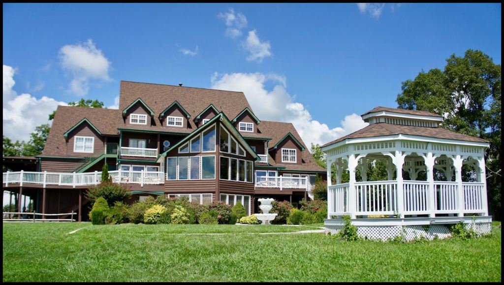
Fort Mountain Retreat and Conference Center
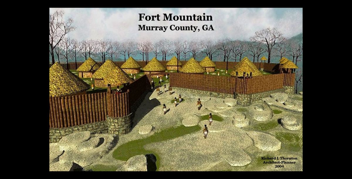
About my computer model of the Fort Mountain Enclosure
The architectural rendering at the top of the article was my second virtual reality model of an archaeological site, after the work that I did for the Hancock County, GA County Commission in Middle Georgia. No one paid me to create this one. At the time, I merely wanted to document the visits that Pilar the Colombian Archaeologist and I made to Fort Mountain and the Old Stone Fort.
The rendering was presented to 2004 Spring meeting of the Society For Georgia Archaeology, which was actually held at the Fort Mountain Retreat and Conference Center. I had been a member of SGA since moving to the townhouse near Etowah Mounds in 1995.
The purpose of the presentation was to show the archaeological firms and academic programs the quality of graphics that professional architects were capable of producing. Most of the illustrations that these firms and university departments put out would have gotten an F or D in Freshman-level Architectural Graphics at Georgia Tech. In short, I was promoting my graphics services and had no clue that within two years, I would be thinking original thoughts, not documenting the orthodoxy of the archaeological profession.
It didn’t even dawn on me even this drawing was a threat to the egos of the Southeastern archaeologists. I functioned in a world of multi-disciplinary teams, where geologists, engineers, architects, landscape architects, interior designers, construction managers, specifications experts and realtors worked together. We openly shared knowledge to produce the optimum finished product for the client.
None of the archaeologists and anthropology students commented on the theory of Fort Mountains being a timber palisade. A few younger anthropology professors did state their amazement that a computer and an ink jet plotter, could produce such beautiful illustrations. It was only the hobbyists in the audience, who stated that the timber palisades indeed answered all the unanswered questions posed by archaeologists and historians.
Six members of the Georgia Council of Professional Archaeologists held their meeting in the back of the conference room. A few minutes after my presentation, the tiny organization’s president got up to make the closing statement for the SGA meeting. He announced (verbatim) “We now know everything there is to know about the Native Americans in the Southeast. It is time to move on to other things.”
I could not believe my ears.

Good one. I’ve been to both. The TN site had a vibe of being more frequented in its heyday but who knows. There was a theory that it was a gathering place for younger folks to mingle at certain times of the year…kind of like Bonnaroo across town.
LikeLiked by 1 person
I was born and raised in Georgia and hiked the Appalachian Trail as Boy Scout. I did not know about this site until I ran across a reference to it on a folk tales website. Thank you for the excellent article!
I love learning Georgia history and was raised in Jonesboro next to a mysterious twin lakes recreation area created by a concrete dam and bridge.
I fished there for sunfish and bream many, many times, and explored the overgrown dam base and the control valve wheels embedded in the concrete. Exploring the surrounding woods and streams are still my best childhood memories.
The lakes and dam are long gone. Jesters creek still flows along the same path only a hundred yards or so from our home on Connell Drive.
We moved to Cedar Grove when I was in the fifth grade and I missed Jonesboro something terrible. I never got to explore for Civil War battle sites or search for relics..I was not aware of the history of the area until years later. But I did attend the 1965 reinactment of the Battle of Jonesboro for the 100th anniversary.
I am 68 years old now but the memories are still vivid in my mind. I can smell the fish and feel their sharp fins in my grubby worm-dirt covered hands.
Thank you again for the history lesson.
Kenneth Bledsoe
bledsoekenneth10@gmail.com
LikeLike
I vaguely remember Twin Lakes as a privately owned recreation park, somewhere near Jonesboro, but I don’t think that I ever visited there . . . at least I don’t remember the visit.
LikeLiked by 1 person