
The mysterious Spear Stones on the headwaters of the Chattahoochee River in Northeast Georgia
They are almost identical to the Spjutstenar (Spear Stones) of southern Sweden and Sjælland Island in eastern Denmark, which date from the Late Neolithic and Bronze Age Periods. Spear stones only had a texture applied to their surface . . . no symbols . . . but they were the direct ancestors of rune stones.
The Peopling of Eastern North America Series
by Richard L. Thornton, Architect & City Planner
Virtual Reality Image above
It is 1653 AD. Richard Brigstock and an employee from his plantation in Barbados are pondering a spear-shaped megalith at the confluence of two major intra-continental trade paths. The location is also at the confluence of the headwaters of the Chattahoochee River and Smith Creek, which flows down from Anna Ruby Falls. This landmark was about a mile north of present-day Helen, Georgia, but disappeared during the late 1800s.
A supposedly identical stone spear was sitting on the lower terrace of the Kenimer Mound, about two miles from my house, until the 1970s or 1980s. This is how we know what the one near Helen looked like. The Kenimer monolith disappeared about the same time that a family, recently arrived from Florida, were removing the stone ruins of the temple on top of the Kenimer Mound to build the foundation and chimney of their dream home. So, the Kenimer Megalith could be still in the Nacoochee Valley area.
I created this 3D virtual reality model of the so-called “White County Petroglyphic Boulder” by laser scanning a six feet (2m) version, which is on my property near the Alek Mountain Stone Oval on the western edge of the Nacoochee Valley in Northeast Georgia. There was also a large stone spear on the plaza of the Kenimer Mound, which is 4.56 km (2.83 mi) northwest of my property. The spear-shaped megaliths were erected vertically and only contain a chipped finish, to emulate the knapping process of a projectile point.
There were several large, engraved boulders in the Gold Belt of North Georgia, which also were located on major trade paths. However, the others lay flat on the ground. Most of those in the Etowah River Basin are engraved with symbols are identical to petroglyphic boulders of County Kerry in southwest Ireland. Most of those in the Upper Chattahoochee, Soque, Nottely and Tugaloo River Basins contain symbols identical to petroglyphs in southern Sweden.
All of the symbols on the Track Rock Petroglyphs can be found at the Nykōping, Sweden Petroglyphic Complex. They have been determine by Swedish geologists to date from around 2000 BC. They are the oldest petroglyphs in northern Europe and generally different than Nordic petroglyphs from the mid-and-late Bronze Age. Yes, it has been a huge advantage for me to have once worked in the heart of the former Swedish Bronze Age civilization and dated a law student at Lund University!

Detail of 1684 map of North America by Jean-Baptiste Franquelin
Nearby indigenous towns
Jean Baptiste Franquelin’s 1684 map of North America shows a large concentration of Proto-Creek, Chickasaw and Soque towns on the Upper Chattahoochee and Soque Rivers. These towns composed an indigenous metropolitan area that was the heart of the Kingdom of Apalache. Apalache appears on European maps until around 1700.
The Proto-Creek town nearest the Spanish trading post was named Choi-te back then. On Georgia maps, it was labeled Chote. The word is Western Maya and means “Principal town of the Cho (Maya tribe) People.” The last occupants of Chote sold their land to a real estate specular to a Burke County, NC real estate speculator in 1822.
To the southeast 6.87 km (4.27 mi) is the great town of Itzate, capital of the Itzate (Hitchiti) Creeks. The word is Western Maya and means “Itza People.” Its land was likewise voluntarily sold to the North Carolina speculator in 1822. Gold was not officially “discovered” near Itzate until 1828.
On the natural terrace above the two Englishmen in the image above is a fortified trading post, mission and mule-breeding farm developed by Florida Governor Benito Ruíz de Salazar Vallecilla in 1646. At the same time, he constructed a pack mule road to connect the trading post to St. Augustine. He later extended the road to the Tennessee River in order to trade with the Kaushete (Upper) Creeks. The road appears on Franquelin’s 1684 map. De Salazar died in 1651.

Detail of 1684 map of North America by Jean-Baptiste Franquelin
According to the official Virginia state history text, Edward Bland, of Jamestown was one of his principal investors. Bland was a cousin of Richard Brigstock. Between 1641 and 1646, he was a wine merchant in Spain. Upon arriving in Jamestown in 1646, he immediately met in private with Virginia Royalist Governor William Berkeley then departed soon thereafter to “inspect” his investments at the southern tip. Bland died in 1652.
Brigstock’s account of his 1653 exploration of what is now Georgia and western North Carolina composes ten chapters of Charles de Rochefort’s landmark 1658 book, Histoire naturelle et morale des îles Antilles de l’Amérique. Brigstock provided extraordinary details on the inhabitants, European immigrants, architecture, cultural history, religion, agriculture and vegetation of that region. He stated that the journey was determine the feasibility of relocating his plantation from Barbados to the “Apalachen” He mentioned spending much time at the trading post and mission.
Perhaps Brigstock’s real intent was to take over management of the trading post, since by that time both De Salazar and Bland were dead. Brigstock ultimately decided to relocate to Virginia, because the Apalachete forbade human slavery and required all unmarried European and African immigrants to marry indigenous spouses.
Who created the Spear Stones in the Nacoochee Valley?
I don’t know! There is too little basic knowledge to answer this question.
Readers will recall that with LIDAR and infrared scans, I have discovered dozens of large and medium sized man-made structures of stacked stones or earth during the past six years in the rugged mountains near my home. Only one, the Alec Mountain Stone Oval was ever examined by a professional archaeologist (Phillip E. Smith of the Peabody Museum). All I can do, for now, is continue documenting these remarkable structures.
I contacted several university anthropology programs in Georgia, begging for help. The University of Georgia, in particular, was sympathetic, but lacked the human and financial resources to do anything now. These programs have dwindled to a handful of students. The only reason that many of the anthropology departments exist at all is that an institution must teach anthropology in order to be called a university! Our Apalache Research Foundation is currently searching for grant programs to support archaeological surveys in Northeast Georgia. We shall see.
The America’s Revealed will now switch to presenting the work that I have been doing in using the latest computer modeling technology, used by us architects, in bringing such locations as the Spanish trading post and St. Augustine to life.
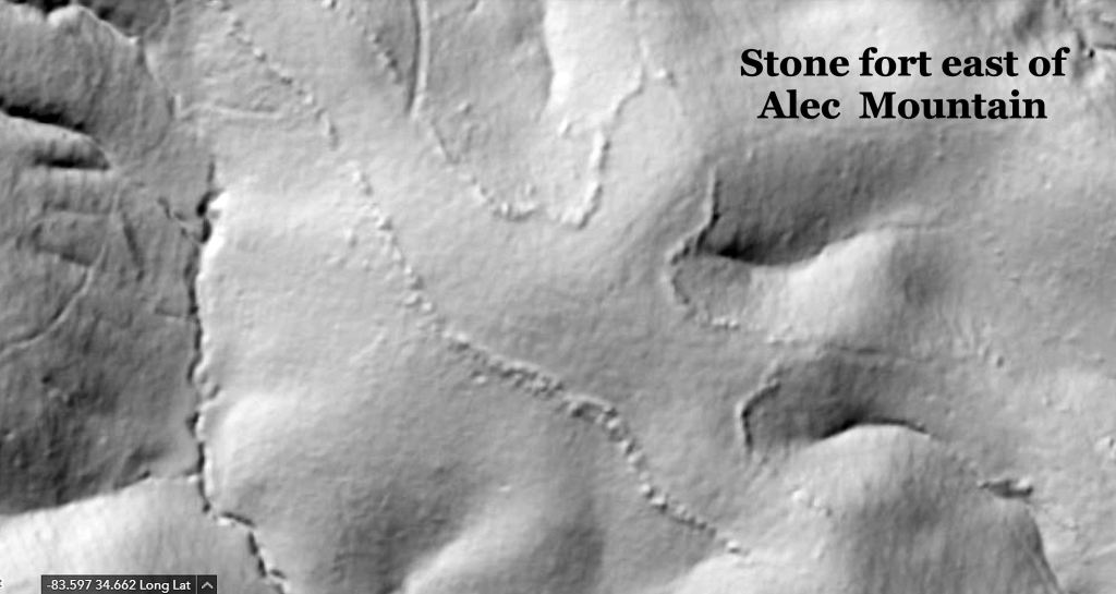
Here is a LIDAR image of one of the extraordinary sites, which await the lucky archaeologists, who come here. It is a massive stone enclosure, two miles east of my house. The longitudinal axis is about 1200 feet long. It is aligned to the Winter Solstice Sunrise.
Many of the boulders on this wall are massive. They would have required dozens of men to move into place. The only thing that I have seen that compares with this fortification is the stacked stone wall along the crest of Cerro Gordo, the extinct volcano overlooking Teotihuacan. I discovered it, while on the fellowship in Mexico. My fellowship coordinator, Román Piña Chán, had no clue that the wall was up there, nor did he know that there ancient stone ruins of a city on TOP of Cerro Gordo.
