
Etowah (Etula) is an Itza Maya word!
Most artifacts have been removed from the museum at Etowah Mounds National Historic Landmark and State Historic Site in Cartersville, GA. As part of a NAGPRA* agreement between the State of Georgia and Muscogee-Creek Nation in Oklahoma, the artifacts have been given to the MCN.
For 64 years, they had been on display at the this museum, about two minutes walk from where they were unearthed. The museum was designed by Georgia Tech architecture professor, Julian Harris, and until 1995 featured on the front facade oversized reproductions of Etowah shell gorgets, cast by Harris.
Twenty-five years ago, Susan Karlson (above) risked being fired from her federal law enforcement job (or worse) by getting word to the Muscogee-Creek Nation that Georgia planned to lease this archaeological zone to a private developer, so he could built a gated golf-course community and “Cherokee History Museum” around the town site. The developer had been a major contributor to the George W. Bush Presidential campaign.
The Mayas In Georgia Series
by Richard L. Thornton, Architect & City Planner
Etymology
Etowah is the Anglicization of the Muscogee-Creek word, Etalwa, which is derived from the Itsate Creek and Itza Maya word – Etula. In all three indigenous languages, the word means “Principal town or capital.”
The word, Tula, was the real name of Teotihuacan. The Totonac, Itza Maya and Itsate Creek word, Tula, was derived from the Maya word for a type of architecture, involving the stacking of stones. Taulli is the Itza Maya, Itsate Creek, Choctaw, Chickasaw, Koasati and Alabama word for a rock or stone.
NAGPRA
The current generation of news reporters are not fact-checking statements by politicians, government officials, academicians, archaeologists, and tribal officials, when they discuss Native American history. It is a very complex topic that usually cannot be properly addressed by broad political solutions.
*NAGPRA = Native American Graves Protection & Repatriation Act of 1991 – In its current amended form, the law defines Indigenous American artifacts and human remains to the cultural property of federally-recognized tribes. Since the MCN is headquartered in Ocmulgee, OK, presumably, the artifacts will eventually put on display at a museum in Ocmulgee, OK.
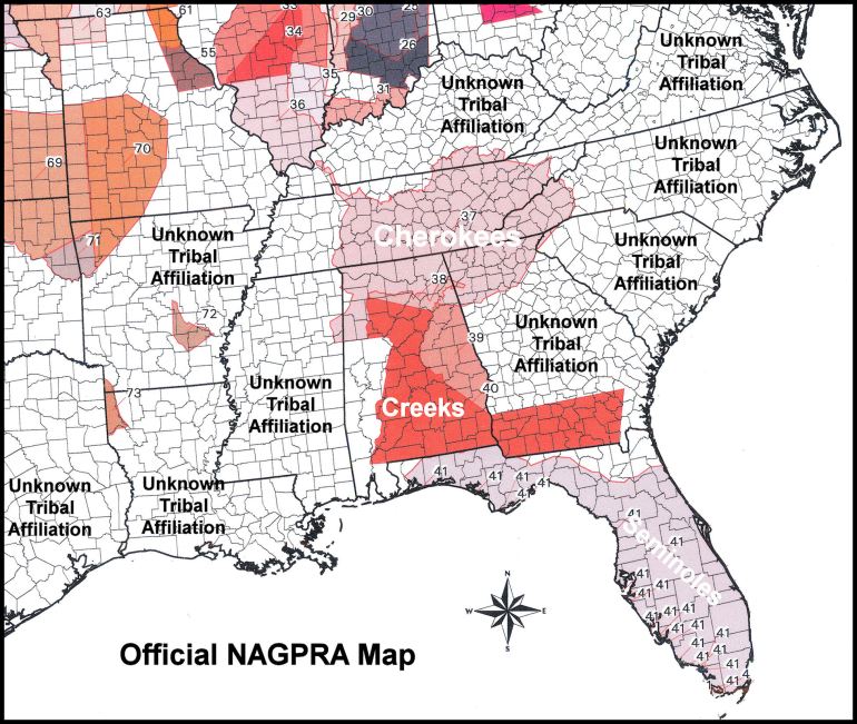
The original NAGPRA map adopted by Congress showed that the Cherokees always occupied the present-day state of Georgia, plus most of the Southeast. A word similar to Cherokee did not appear on any map of the Southeast until 1715. There were no Cherokees in Georgia, when the colony was founded 1733, while they owned no land in Georgia other than Rabun County and eastern Towns County until 1785. They were gone after 1838. This map is a political compromise in Congress, whereby most of the land in the Southeast is labeled “Unknown Tribal Affiliation.”
All of the “Cherokee” lands in northern Alabama, central Tennessee and western Kentucky were ceded by the Chickasaw in 1805. The Seminoles are shown as always living in Florida, when they did not arrive until the mid-1700s or later. They were really Creek immigrants from Georgia.
This official NAGPRA map of the Southeast does not even mention the Choctaw, Chickasaw, Catawba, Miccosukee, Alabama, Shawnee, Chickahominy, Monacan, Nansemond, Pamunkey, Rappahannock, Mattaponi, Chitimacha, Coushatta, the Jena Band of Choctaw, and the Tunica-Biloxi. . . . all federally-recognized tribes.
The map also does not mention the Uchee (Yuchi), Natchez, Saponi and Florida Apalachee. They were major tribes in the Colonial Period, but were never recognized separately by the United States government.
Politicized Anthropology
Throughout the 20 years that I have published research reports to public, I have tried to point out the many situations, where the history that our students read in textbooks, is not the whole truth or even is fictional. Few people knew that until 2021, I was being guided behind the scenes by Dr. James Loewen, author of Lies, My Teacher Told Me. Jim was convinced that altered history and anthropology were tools for manipulating societies into irrational behavior.
The most common cause of inaccurate Native American history occurred within universities. Academicians without adequate knowledge of a subject, published flawed interpretations of the past. They then used political connections to make those flawed statements . . . orthodoxy. Anyone who published interpretations different than theirs would be attacked viciously. Look how long it took anthropologists to admit that the people making Clovis points were not the first humans in the Americas . . . even though the oldest Clovis points are found along the Savannah, Ogeechee and Altamaha Rivers in Georgia.

This is a large model of the Creek Capital of Koweta on the Chattahoochee River in West-Central Georgia. It was built for the Muscogee-Creek National Council in 2008. The precise architectural model is based on the verbal descriptions, measurements and drawings made by William Bartram in 1776. The site is now in Downtown Columbus, GA.
Several years ago, self-styled, quite unknowledgeable, “elders” among the Oklahoma Creeks created an uproar, telling people there that I was a white man trying to steal their heritage by making Creek towns look like Maya towns. I received several calls from strangers in the Oklahoma Creek Nation to tell me that their elders said that they knew that the Creeks originated in Oklahoma and did not have Mexican ancestors. I asked them if they had visited any of our ancestral towns in Georgia, tested their DNA or looked at an Itza Maya dictionary. They said no.
Actually, traditional Creek towns in Middle and South Georgia DID strongly resemble Pre-Columbian towns in Tabasco State, Mexico. Those in northern Georgia and along the Savannah River Basin, didn’t. The “elders”, who were really shamans, planned to have a ceremony in which this model and others would be ritually destroyed by sledge hammers. The models were covertly removed from MCN buildings during the night and hauled off to a privately owned warehouse for safe-keeping.
Among the Southeastern Indigenous peoples, who were forcibly marched to Oklahoma, there is another problem. These people have been gone from the Homeland for two centuries. Most have never even seen a Pre-Columbian town site in the Southeast, whereas I grew up being taken by relatives to our heritage sites . . . even by a Methodist minister, who was part-Creek. They assume the cultural practices of those who came to Oklahoma were the same as they had always been. However, they have intermarried with other tribes and picked up cultural traditions from other tribes. The “Five Civilized Tribes” didn’t even have tribal governments from 1905 until the 1970s.
When I read books published by educated Muskogee-Creek citizens in Oklahoma, I quickly pick up that they think of themselves as members of a single ethnic group that has been in existence for thousands of years. They think that the Kaushete (Upper Creek) Migration Legend is the Muskogee Migration Legend. It is not. Kaushete is an Itza Maya word, by the way.
There is no Muscogee-Creek Migration Legend. The Muskogee-speaking tribes originally lived in the North Carolina Mountains between Asheville and Franklin. On 17th century French maps, they are shown there and labeled Kofitache (Mixed People – Descendant of.) Apparently, they began moving down into present-day Georgia in the 1600s.
The reality is that the Creek Confederacy was created by 28 distinct tribes in 1717, (one of whom were the Kaushete) and none of whom had architectural traditions resembling was built by the Creeks, when they first arrived in present-day Oklahoma. No one in Oklahoma seems aware that the Chickasaw were founding members of the Creek Confederacy and are specifically mentioned in the Kaushete (Creek) Migration Legend . . . but dropped out when told that they would have to speak Muskogee in political meetings.

Georgia Creeks celebrating the Green Corn Festival in 1976!
I surely hope that the Oklahoma Creeks’ misunderstanding of their heritage does not manifest itself in the future Oklahoma Etowah Mounds exhibits. For example . . .
- In 2006, an official of the Trail of Tears Association examined U. S. Census records during the Indian Removal Era. She was shocked to discover that over 22,000 Creeks and Uchees remained in Georgia in 1840, after the Creek Confederacy had ceded all of its lands there in 1827. The remaining Creeks were concentrated in traditional Creek communities on major rivers, which opted not to relocate, when their land was ceded earlier by the Creek Confederacy.
- Of the 3,000+ Upper Creek adults living in the Cherokee Nation, only 800 were captured by troops and sent to Oklahoma with the Cherokees. The descendant of Upper Creeks, who evaded capture, are concentrated in Floyd, Fannin, Union, Towns, Gilmer and Murray Counties, GA. Several Upper Creek and Towns County Creek communities are theoretically eligible for federal recognition.
- About 4,000 Creeks remained in Alabama in 1840.
- Approximately 15,000 Creek men, women and children were forcibly removed to Indian Territory (modern-day Oklahoma) during the Trail of Tears. Around 3,500 died during the journey. Thus, over twice as many Creeks and Uchees remained in Georgia and Alabama as resettled in the Indian Territory (now Oklahoma).
- The word Muskogee (Mvskoki) did not exist until around 1748. The ruling elite family of the Creeks were of substantial Sephardic Jewish heritage. Their name was Bemarin . . . shortened to Brim by the Anglo settlers. The Bemarins coined this tribal name by joining the Sephardic word for “mixed ethnicity” with a Creek suffix for “people or tribe.”
- In 1776, William Bartram did not see any “Creek Squares” in Georgia. The towns either looked like the indigenous towns in Tabasco and southern Veracruz or else had oval plazas. He did describe and draw Creek Squares in Tuckabatchee, Alabama and near Pensacola, Florida. Tuckabatchee moved from Alabama back to its original location at the Six Flags Over Georgia amusement park site in late 1776.
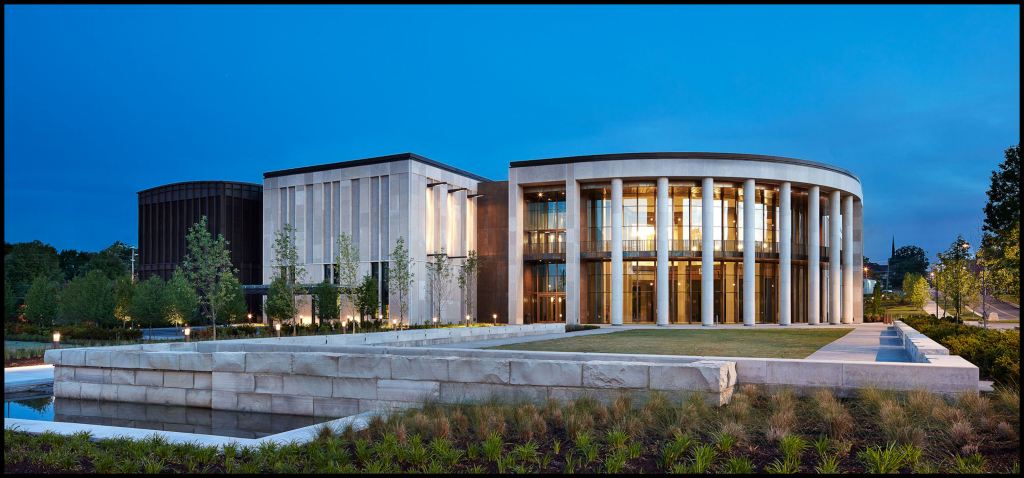
The Tennessee State Museum in Downtown Nashville
Why you can still see Etowah artifacts in Nashville
Here is another archaeological booboo. Tennessee archaeologists did not fact-check an amateur artifact collector from Ohio then based much of their understanding of Central Tennessee’s Pre-Columbian history on those artifacts.
During the Civil War, Colonel (later General) Gates P. Thruston rose up the officer ranks of the First Ohio Volunteer Regiment. While acting commander of the First Ohio during the Atlanta Campaign, he was also on the staff of General Thomas. After the First Ohio was fully mustered out, he was appointed Judge-Advocate General of the Army of the Cumberland and Military Governor of the Nashville, TN. District.
Thruston subsequently built a huge mansion In Nashville to display a collection of over over a hundred thousand Native America artifacts. At his death, they were donated to Vanderbilt University. The best examples became the initial exhibits on display at the Tennessee State Capital Museum. In his landmark book, Antiquities of Tennessee, Thruston claimed that he had purchased the artifacts from men in his regiment, while they worked on fortifications in Nashville. Oh really?
In Virginia, I was the owner of a Colonial Era farm in the Shenandoah Valley, originally owned by George Washington. In 1864, it became the site of one of the largest cavalry battles of the Civil War. In 1993, I was appointed by NPS Director Roger Kennedy to the Advisory Council of the American Battlefield Protection Program. I subsequently developed a library that includes 14″ x 17″ format, full color, archival quality copies of most of the battlefield and fortification drawings, prepared by US Army and Confederate Army engineers. They include maps of Cartersville and Etowah Mounds during the Atlanta Campaign. Thus, I am in a unique position to fact check General Thruston.
- The First Ohio Volunteer Regiment was never even stationed in Nashville, when the fortifications were constructed or even occupied.
- The fortifications were constructed by Black Freedmen, under the direction of an Engineering Regiment.
- The fortifications involved earthworks on several large hills surrounding the west, south and east edges of Nashville. No fortifications were constructed in the Cumberland River Floodplain, where Native American villages, burials and mounds were located.
- The First Ohio Volunteer Regiment was scheduled for mustering out of service in Sept.-Oct. 1864. Therefore, as General Sherman’s Army crossed over the Etowah River May 23, he placed the Ohioans on the Etowah River to guard the Etowah River railroad bridge and an area near Etowah Mounds, where the river could be forded. The regiment was literally stationed within the mounds. The larger mounds were altered to become artillery forts . . . hence, the odd shape of Mound A.

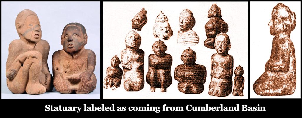
Ceramic statues in the Thruston Collection – now on display in Nashville
- Author George White wrote in 1855 that most of the families in the county maintained large Indian artifact collections, obtained from paying the owners of Etowah Mounds to dig there, plowed fields or while hunting. There were also small archaeological museums in the two colleges and courthouse. All of these artifacts were gone, when residents returned to their homes, after hostilities ceased . . . well, those who still had homes.

Exhibits at the Tennessee State Museum
- We have further descriptions of the many statues and artifacts in Cartersville area homes from pioneer anthropologist, Charles C. Jones, Jr. in his book, Antiquities of the Southeastern Indians. Jones spent considerable time in the Cartersville Area in 1859. He even paid a civil engineer to survey the Etowah Mounds town site.
Exhibits at the Tennessee State Museum
- The Ohioans remained at Etowah Mounds for over four months. They had little to do, so spent their time ransacking houses and digging for artifacts. In his memoirs, the Rev. Sam Jones, a famous evangelist from Cartersville, stated that “they robbed almost all the valuables from the houses in and around Cartersville . . . including thousands of Indian artifacts that had been proudly on display in the houses.”
- At the end of their stay at Etowah Mounds, the regiment was ordered to burn all commercial, educational, industrial and agricultural buildings in the county . . . plus two college campuses and the entire town of Cassville, which was then the county seat. This was four months AFTER any Confederate troops were in the area.
- In his book and interviews by newspapers after the Civil War, Thruston stated that he was actively involved with the series of battles around Atlanta. He was not. He was a staff officer, living comfortably in a mansion near Etowah Mounds . . . and assembling his artifact collection, unearthed or pillaged by the men in his regiment.
- While Military Governor of Nashville and then a leading citizen of Nashville, Thruston continued to pay people to excavate mounds for him around Tennessee. These artifacts were added to the core collection obtained around Cartersville, GA. Eventually, Thruston was thought to have owned something around 200,0000 artifacts, maybe more.
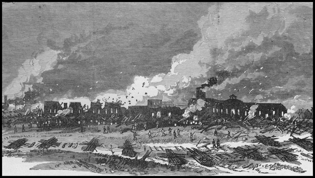
Soldiers of the First Ohio Volunteer Regiment burning Downtown Cartersville, GA
Thus, Thruston concealed the real source of his original large collection of artifacts, because of their association with atrocities committed against helpless Southern civilians near the end of the Civil War. Ironically, many residents in Northwest Georgia at least initially, opposed secession. A troop of pro-Union militia cavalry from Northwest Georgia repeatedly guided Sherman’s Army around impregnable Confederate fortifications. In fact, Sherman’s Army would have probably been defeated, had not he been assisted by loyal Unionists in Northwest Georgia. However, many turned bitterly anti-Northern, after Sherman torched their region in September 1864.
It is highly likely that any of the original artifacts, owned by Thruston, which are on display at the Tennessee State Museum, are from the Etowah Mounds, Georgia site, not Tennessee.

Meanwhile, Cartersville and Bartow County, Georgia are reeling from the loss of tourism income, because their internationally famous museum is an empty shell and their iconic two marble statues are being moved 800 miles away. Guess the state bureaucrats didn’t think of that. They never do.
