Chichen Itza! New styles of architecture and pottery appeared on the Ocmulgee and Etowah Rivers in Georgia, immediately after the suburbs of Chichen Itza were depopulated.
HOWEVER, as Dr. Román Piña Chan quickly observed on July 6, 1970 . . . Etowah’s shell-tempered, Plain Redware pottery was identical to that found in the suburbs of Chichen Itza, but in Etowah’s royal burials, which archaeologists have always focused on, were found ornate stamped ceramics, similar to that produced by the Swift Creek Culture five to eight centuries earlier.
A couple of years before immigrants appeared at a horseshoe bend in the Etowah River, the same new architecture and pottery appeared on a similar horseshoe bend in the Ocmulgee River, two miles from the big mounds . . . the “Lamar Village.” The Native American history of the Southeastern United States is not a simple children’s bedtime story.
The Mayas In Georgia Series
by Richard L. Thornton, Architect & City Planner
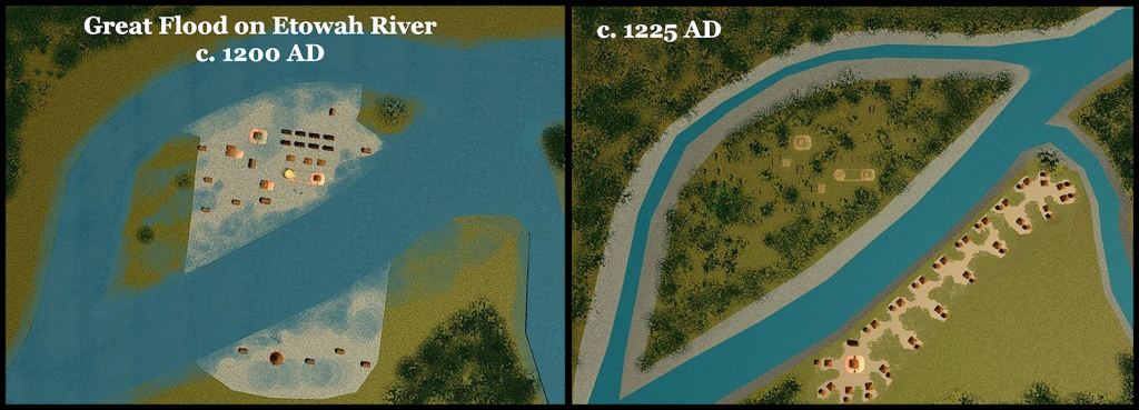
The Great Flood of c. 1200 AD destroyed or cut off much of the town.
What museums, TV shows and archaeologists never tell you
A series of at least eight distinct ethnic groups have occupied towns or villages at the Etowah site from c. 1000 BC to c. 1700 AD. The post-1995 exhibits at the Etowah Museum lied. They told you that no one had lived there before 1000 AD or after 1585 AD. All of these peoples built mounds, but most of the early mounds are on the south side of the Etowah River and not on state-owned property.
You see, until around 1200 AD, all of the town was on the south side of the river. The vestiges of most of the Pre-1200 AD occupations were either destroyed by the flood or are not on state-owned property.
What you formerly saw in the Etowah Mounds Museum were mostly artifacts unearthed in elite burials from the occupation of Etula between 1000 AD and 1200 AD, during the 1955-1956 expedition, funded by the State of Georgia. These burials were in the levels of Mounds B and C BELOW the current grade of the archaeological zone.
Grave robbers and earlier trophy artifact-hunting archaeologists from the Smithsonian Institute in Washington, DC and Peabody Institute in Massachusetts thought that there was nothing more to take back home. Many or most of these more sophisticated artifacts have disappeared into private collections.
The Smithsonian’s Site Supervisor in the mid-1880s, John P. Rogan, personally excavated the much older Dunlap-Deptford-Cartersville-Swift Creek Culture mounds on the current south side of Etowah River, while local laborers toiled at Mound C on the north side of the river. He sold these artifacts to private collectors. He then used the funds to build the Rogan Building in 1888 on West Main Street in Cartersville, GA. I was the Architect for its restoration.
In 1939, archaeologist Robert Wauchope excavated these same 3000-1500 year-old mounds, but published his findings, assigned archaeological site numbers and sent the artifacts to the University of Georgia. Archaeologist Arthur Kelly excavated 17th century Proto-Creek buildings on the plaza next to Mound A. In 1971, he showed the footprints of those building to me. They are still visible on satellite imagery. The grass is a deeper green over these structures.
In 1974, a team of National Park Service archaeologists, working at (then) Ocmulgee National Monument, discovered that the Lamar Village was founded in the 990s AD, not around 1200 AD as it’s museum tells you. The newcomers built the same style buildings as were in the suburbs of Chichen Itza until around 1000 AD and made the same styles of pottery that would appear in a few years at Etowah Mounds. That’s one of the mysteries that have not been solved! There is no excuse for the former museum exhibits and a subsequent generation of archaeologists, concealing the true age and extent of the Etowah Mounds Archaeological Zone.
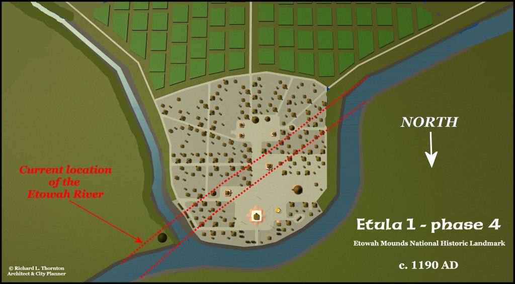
Most of the “Itza” phase of Etowah is on the opposite of the river today.
In all of the archaeological digs, the vestiges of the regular folks were largely ignored, except for the 17th century houses, excavated by Kelly. Their lives were very similar to those of the commoners in southern Mexico. They were not buried with fancy pottery or ornate copper artefacts! Although hundreds of skeletons were removed from their graves at Ocmulgee and Etowah, most were “disposed of” by the archeologists. None have been analyzed for DNA. This is a serious problem for scientific study in the Southeast.
There are NO DNA test markers for Pre-Columbian mound builders in the Southeastern United States. Geneticists and archaeologists are making broad statements about the peopling of North America without ANY knowledge on the region, where most of the people lived before the Colonial Era. There were more people living, just in the Province of Coosa in Georgia in 1492 AD, than all of the Great Western Plains.
The survivors of the Great Flood around 1200 AD moved northward into the higher Georgia Mountains and Upper Tennessee River Valley, where they continued to build the weird corner-door houses until the early 1700s, when they switched to log houses. They called themselves Tulasi (Tallassee in English), British settlers called them, Upper Creeks, while archaeologists call them the Dallas Culture. Direct descendants of the Tulasi still live in Union, Fannin, Towns and Gilmer Counties of the North-Central Georgia Mountains.

Archaeologist Arthur Kelly unearthed a Tulasi/Custate town at the confluence Coosa Creek and the Nottely River near Blairsville, GA which was occupied continuously by Upper Creeks until the early 1830s. It is now under Lake Nottely. The Upper Creeks were allies of the Cherokees during the Chickamauga-Cherokee War after the American Revolution. After their land was given to the Cherokees by the United States in 1784, the Cherokees allowed the North-Central Mountain Upper Creeks to remain, but their names were not on the “arrest list” of Cherokee tribal members during the Indian Removal Period. At least 2,200 Upper Creeks remained in Georgia after the Trail of Tears.
Chichen Itza’s secrets
Between around 800 AD and 1000 AD, while most of the large Maya cities to the south were being abandoned, Chichen Itza thrived. The town had been founded by Itza refugees from Chiapas after the El Chichon Super-volcano exploded in 800 AD.
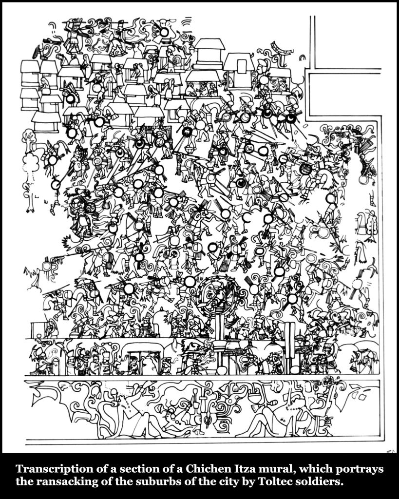
Now that archaeologists can read the Maya writing system, we know that Chichen Itza was governed until the late 900s AD by a constitutional monarchy-representative democracy identical that of Creek provinces in the Colonial Period or Great Britain up to the 20th century. After that time, it was ruled by invaders with cultural practices similar to that of the Toltecs and Totonacs of Central Mexico. Human sacrifice, both from removal of the heart and drowning, was introduced. The cutting out of victims’ hearts was not practiced by most other Maya city states.
In the two landmark books, Chichen Itza, by Román Piña Chan (1992) and Lost Kingdoms of the Mayas by my dear friends George & Gene Stuart* (1993), the authors were puzzled by the sudden disappearance in the 990s AD of the “middle class” residents of Chichen Itza, living in the suburbs. Many of the inscriptions in Chichen Itza could by then be read, but they were silent as to where the middle class went. Their corner door houses were replaced by more typical Maya houses, like which dot the landscape of the Yucatan Peninsula today.
The authors estimated the population loss to be in the thousands, but no evidence of a mass execution could be found . . . nor could they identify in other location in Mesoamerican where the Middle Class and Commoner Itzas relocated. Neither book mentions that the same houses, but often, a different style pottery, appeared in Georgia soon thereafter.
What can be stated with confidence is that there was a dramatic cultural and architectural change in the Southeastern United States that started just before 1000 AD at Ocmulgee National Historical Park and Etowah Mounds National Historic Landmark. It quickly spread outward from these large towns.
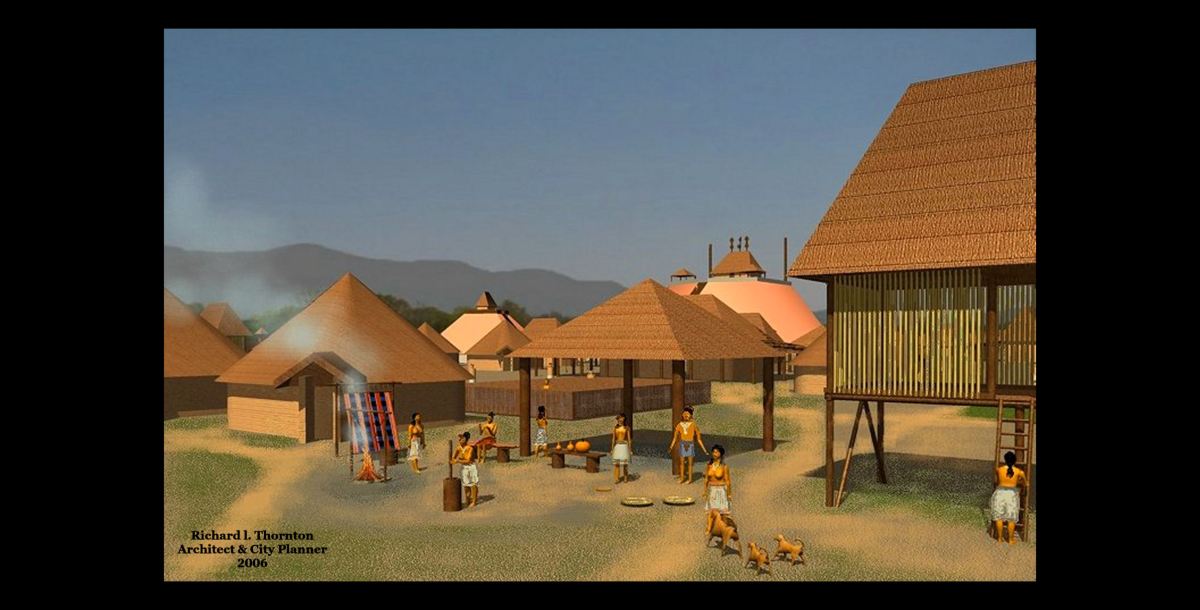
Prior to that date, the acropolis at Ocmulgee had been filled with large round houses, typical of northern South America. Afterward, the round houses were steadily replaced with large rectangular houses that were typical of wealthy Soque and Chontal Maya merchants in southern Mexico. Modest corner door houses proliferated in the suburban villages of Ocmulgee.
Within corner door house neighborhoods, somewhat larger houses with front porches appeared. Arthur Kelly interpreted these homes as the residences of neighborhood leaders. Kelly initially also identified large bungalow-like structures with wrap-around porches, which he labeled “terrace houses.” Further analysis has determined them to be communal dining halls.
Very little of the 1000-1200 AD neighborhoods have been excavated at Etula (Etowah.) In “ground radar” scans, they are concealed by more recent houses, built in the town.
+

+
This early mural at Chichen Itza described virtually the same corner-door houses and center-door houses with porches, which became iconic for proto-Creek towns in Georgia, but soon disappeared in the Yucatan peninsula.
In addition, the earliest radiocarbon date for the acropolis at the Track Rock Terrace Complex in northern Georgia is 1018 AD. These sudden changes certainly suggest close encounters of a third kind between southern Mexico and Southeastern North America.
*Personal Note
In February 1993, George and Gene Stuart invited Vivi D’Abundance and me to be their guests at the posh Occidental Restaurant in Downtown Washington, DC. The Occidental’s menu featured goat cheeses from my creamery in the Shenandoah Valley. Gene looked frail, but she didn’t explain why. The purpose of the occasion was to present us with signed copies of their new book, Lost Kingdoms of the Mayas.
We discussed the several times when large populations of Mayas disappeared, but it did not dawn on me that the discussion had any relevance to me professionally. This was the last time, that I ever saw George or Gene. Gene died of cancer in August 1993. Don’t know why, but George never informed me that she was critically ill or when she died.
