
The quest begins in 2012 . . .
Twentieth century archaeology professors at the University of Georgia concealed over a thousand Nazca Plain-type conehead skeletons, while their counterparts in Florida based their understanding of Native American history on a fake location for 16th century French fort . . . created by real estate speculators.
While being interviewed for the premier of “America Unearthed,” I mentioned that the Itza Mayas, were just one of many peoples, who had been ancestors of the Indigenous Tribes of the Southeastern United States.
The real situation was that I knew that there were many, many place names and surviving indigenous words, which could not be translated with a Muskogee-Creek, Choctaw, Chickasaw or Alabama dictionary. An increasing number of mystery words were being translated with an Itza dictionary. However, many were not!
by Richard L. Thornton, Architect & City Planner
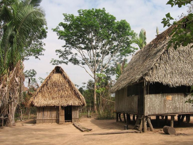
Kitchen and house of a Shipibo village in Satipo Province in eastern Peru. The provincial capital is also called Satipo. There was also a province and provincial capital in southeastern Georgia along the Satile (Satilla) River called Satipo.
Following the evidence . . . wherever
When I began the “People of One Fire” newsletter in 2006 . . . forerunner of this website . . . I promised the readers that I had no preconceptions . . . that I would follow the evidence, wherever it took me . . . without postulating theories, which pretended to have all the answers. That I have done, but with the new genetic information coming in, the journey has taken me to a point of understanding that I would have considered pure heresy in 2006.

The nobility of the original city at the site of Savannah lived in a royal compound on Irene Island, which is now part of the Port of Savannah. The main town and several other mounds were located on Yamacraw Bluff, where James Edward Oglethorpe laid out the city of Savannah.
Uncovering concealed evidence
Initially, when I embarked on this quest for knowledge, I was shocked by the concealment of very important historical knowledge by academicians . . . if these facts happened to conflict with somebody’s orthodoxy. For example . . .
(1) 1735 – The Georgia Colonial Archives stated that the original capital of the “Creek Confederacy” was located where the city of Savannah now stood. All of the residents of this city were composed of various peoples, who arrived on the South Atlantic Coast by sailing across ocean waters.
(2) 1838 – A History of Georgia by William Baker Stevens opens by stating that early colonists in Savannah and the southern tip of South Carolina encountered a tribe of light-skinned, Indians with Irish names. They spoke an archaic dialect of Gaelic that could still be generally understood by Irish and Scottish immigrants in Savannah. Because they were so culturally similar to the colonists, they quickly were assimilated into its mainstream population.
(3) 1926 – Archaeologist Warren K. Moorehead (of Etowah Mounds fame) excavated three Pre-Columbian mounds containing Woodland and Mississippian artifacts on the Ellijay and Coosawattee Rivers near downtown Ellijay, GA. Within the hearts of two of the mounds, he unearthed heavily oxidized iron tools and weapons.
(4) 1928 – Peruvian archeologist Julio Tello found hundreds of cone-shaped skulls in the Paracas region of Peru. Their unique shape has prompted speculation over time, including various claims of an extraterrestrial origin. Paracas is the Hispanicization of the Indigenous American (Panoan) word Parakausha, which means “Ocean Elite.”
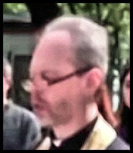
For many decades, the Paracas skeletons were promoted as being extraterrestrials. In 2022, DNA was extracted from Paracas skeletons and tested by several genetics labs with stellar reputations. They were found to belong to a race that originated in southern Ukraine then interbred with several Indo-European peoples to become the Huns, Burgundians, Goths and Lombards. The cone-shaped helmets, worn by these invaders of the Roman Empire was necessary to fit their skulls. Some “eggheads” still live in southern Ukraine, as evidenced by this Ukrainian Orthodox priest in Odessa.
(5) 1934 – Smithsonian archaeologist, James Ford, unearthed many copper, bronze. iron and steel weapons & tools along the south side of the mouth of the Altamaha River in southeast Georgia. They were at an occupation level also containing typical Native American ceramics and stone tools. These artifacts were on display at the San Domingo State Park Museum nearby throughout the remainder of the 1930s and early 1940s. However, state park officials have refused to cooperate with me concerning their current location.
(6) 1935 – Archaeologist Arthur Kelly (of Ocmulgee fame) excavated a Native American village and cemetery on the grounds of the Indian Springs State Park. He described the skeletons as being extremely tall with strange oversized skulls . . . he thought perhaps due to the entire village having some genetic disorder. No one seems to know where the skeletons or their artifacts are today.
(7) 1939 – Archaeologist Roger Wauchope dug test pits at a large town site on the Etowah River, about six miles (9.7 km) upstream from Etowah Mounds. Its location is now immediately north of Allatoona Dam. The occupants of this town produced sophisticated ceramics, despite all having some strange brain disease.
He initially assumed that the population practiced some sort of skull deformation, but then unearthed the skeletons of recently born babies with the same shaped heads. He also noticed that the female skeletons were different than other homo sapiens in that there was a much larger opening in the pelvic bones to allow the larger fetus to be birthed freely. In fact, there were such differences between these skeletons and normal homo sapiens, they could have been classified as a newly discovered hominid species.
Wauchope was simultaneously the first anthropology professor at the University of Georgia. However, he did not publish his archaeological report on Northern Georgia until 1966 . . . while he was a professor at Tulane University. He never specifically mentioned the strange skeletons on the Etowah River in academic lectures and articles to fellow members of his profession.
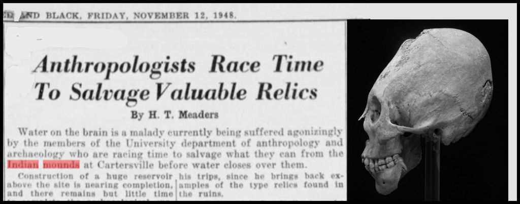
(8) 1948 – While finishing up his archaeological survey of the Allatoona Reservoir, before it filled with water, archaeologist Joseph Caldwell of the University of Georgia went back to the large town on the Etowah River, surveyed by Robert Wauchope. A more comprehensive excavation of the town revealed over a thousand Nazca Plain-type egghead skeletons. However, without consulting a pathologist, Caldwell officially interpreted the skulls of being the result of a town-wide affliction by hydrocephalus. Unlike Wauchope, he did not notice that the skeletons were different from most homo sapiens.
Caldwell left almost all the human remains, unearthed, to be covered within a few days by the waters of Lake Allatoona. Neither he nor his boss, Department of Anthropology Director , Arthur Kelly, requested an extension from the U. S. Army Corps of Engineers to fully study this large town . . . nor did they notify the general public of the unusual skeletons. Caldwell brought ONE skull back to Athens, GA to show his anthropology students.
+
That we know at all about Calldwell’s and Wachope’s discoveries of Paracas type skeletons on the Etowah River, we can thank the November 12, 1948 edition of the UGA campus newspaper, “The Red and Black.” People of One Fire member, Ed Reilly, found a digital copy of the article and forwarded it to me.
I was flabbergasted. Julio Tello’s eventual discovery of a few hundred Paracas skulls over a five year period repeatedly made international headlines. Over 1,000 Paracas skulls in one time in a two months time should have made international headlines, but didn’t. I was able to eventually obtain a copy of Caldwell’s archaeological report. He barely mentioned the unusual skeletons and stated that he had found “some” with diseased skulls.
Between 1947 and 1984, the generous funding by the US Army Corps of Engineers of archaeological excavations by the UGA Department of Anthropology helped maintain UGA’s national reputation in anthropology. Apparently, Kelly and Caldwell decided that remaining in the good graces of the U.S. Army Corps of Engineers was more important than an archaeological discovery that would change the history of the Americas. If they made a big deal out of the Paracas skulls on the Etowah River, the filling of Lake Allatoona would be delayed.
2005 – The Dean of Florida Archaeology, Gerard T. Milanich, wrote an article. “Devil In the Details” for Archaeology Magazine*, which he proudly announced the proof that Teo de Bry had fudged his prints of water color paintings of the Native Americans by resident Fort Caroline artist, Jacques de Le Moyne. The prints were made in the early 1590s, after Le Moyne had died.
*Archaeology Magazine, Volume 58 Number 3, May/June 2005
Millanich stated that the Indians in de Bry’s prints wore clothing and carried weapons, typical of South American Indians. He closed by stating: “After reexamining all the evidence, I now question whether Jacques le Moyne actually did any paintings of Florida Indians.”
Dr. Millanich was correct! Jacques le Moyne was painting Georgia Indians . . . most of whom on the coast originated in the Caribbean Basin or South America.
Millanich stated his qualifications for writing the article were from a postdoctoral fellowship in 1972-73 at the National Museum of Natural History. It’s a shame he didn’t stop by the Library of Congress. You see . . . for the past 50 years, Florida academicians have used a fake location for Fort Caroline as a benchmark for determining the Native American history of the South Atlantic Coast. They would have been far better off, buying Arawak and Taino dictionaries.
How a major boo boo happened
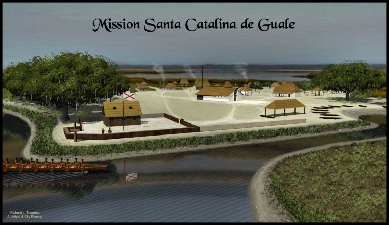
2007 – While working on the three dimensional architectural drawings of Mission Santa Catalina de Guale for the American Museum of Natural History, I discovered that . . . The mouth of the St. Johns River was unknown to the Spanish until around 1600 AD and impassible to sea-going vessels until 1860. All European Colonial Period maps that mention Fort Caroline, place it on the south side of the Altamaha River in present day Georgia. A 1794 map of the southern states reads: “Altamaha River ~ formerly the May River.”
All French and Spanish official reports place the location of Fort Caroline at the latitude of the mouth of the Altamaha River and the location of St. Augustine from September 1565 until March 1566 on the Satilla River in Georgia. The town was then moved to its current location in Florida, because the more sophisticated soldiers of Georgia tribes were wiping out the Spanish colonists . . whereas Florida Indians were not so sophisticated or numerous.
In his report to the Spanish king, Governor Pedro Menendez specifically mentioned the latitudes and longitudes of the initial and then permanent locations of St. Augustine. The so-called “First Thanksgiving Service in North America” was on the banks of St. Andrews Sound, Georgia . . . not in St. Augustine, Florida.
In 1845 a real estate speculator from New York dreamed up the myths about the Fountain of Youth being in St. Augustine and Fort Caroline being in Jacksonville to help sell his land. In 1925, the Jacksonville Chamber of Commerce arbitrarily chose a site with a good view of the river as the site of Fort Caroline. No 16th century building ruins or artifacts have been found there.
In 1951, the Jacksonville Chamber of Commerce gave 50 acres at that location to the US Government so a sleepy congress could declare those 50 acres the Fort Caroline National Memorial. In 1961, President Johnson funded the construction of an inaccurate 1/12th scale model of the fort on that 50 acres, so tourists would have something to look at. It was an award to the local congressman for supporting the Civil Rights Act.

Apalachete Indians in Northeast Georgia using river canes to separate gold from sand. They are wearing a hair style, typical of South America. The Florida Apalache never called themselves Apalache until told by the Spanish that was their name. However, both peoples are from South America.
2012 – I stumbled across Millanich’s article in February 2012, while doing research for my book on the Track Rock Terrace Complex. I was trying to find the painting above by Jacques Le Moyne. The first thing that caught my eye was Millanich’s obsession with the Timucua . . . whose actual name was Tamacoa (trade people). Their real name indicates that they were the result of Chontal Mayas intermarrying with Arawak peoples.
Much of what Wikipedia tells you about the indigenous peoples on the Georgia Coast does not jive with eyewitness French and Spanish accounts. What you read is the result of academicians making speculations and then citing each other’s speculations as fact, before going further out into lala land.
The information has been altered to jive with Fort Caroline being in the wrong location. According to the memoir of the commander of Fort Caroline, René Goulaine de Laudonnière, the Tamacoa’s northern boundary was over 80 miles south of Fort Caroline. Very few people out in the real world give a flip about such things, so the Florida academicians get away with it.
The Tamacoa were the enemies of the tribes near Fort Caroline. So, Millanich, unknowingly was right. It is highly unlikely that Le Moyne ever painted a Timucua from Florida. They would have probably taken his scalp. He did paint quite a few Georgia Indians, however. All but one of those tribes soon moved to northern Georgia to get away from the Spanish. The one that stayed on Cumberland Island and nearby mainland, the Mocama, soon became extinct.
René de Laudonnière stated that there was large, powerful tribe to the south of Fort Caroline, whose capital was Satipo. The capital adjoined St. Andrews Sound in Georgia. Out of curiosity, I Google-searched with the key word. “Satipo.” to see if any archaeological work had been done there.
Holy Jehoshaphat! There was a province and provincial capital in eastern Peru also named Satipo. This province was the homeland of many Panoan Language tribes. I instantly could translate several place names along the Georgia and South Carolina Coasts with a Panoan dictionary. That was a very different history of the South Atlantic Coast.

+
This De Bry print of a painting by Le Moyne shows the Sati-uriwa (King of the Colonists in Panoan from Peru) pointing out a marble monument placed at the mouth of Altamaha River in 1561 by Jean Ribault. The St. Johns River did not even have a mouth until the first channel was dredged by US Army Corps of Engineers in the 1820s!
Note that the king is extremely tall, has an over-sized egghead and is wearing the same raccoon tails that were worn by Chontal Maya traders. Florida academicians label the entire tribe Satiouriwa, but their name was the Satile or Satikoa. Both words mean “Colonist People.”
Now you know!

Thank you, sir, for waking me up to the truth. People does not hate their government enough. I have researched and researched how to use LiDAR. I have had no luck. I really believe there is something huge going on at peoples lake in Chatsworth Georgia. I know you said that you would help me if I got you the location with her I don’t even know how to do that. If you get time would you look at this place?
LikeLiked by 1 person
You can obtain the exact latitude and longitude of the site with Google Maps. Just click “What’s here” and Google will give you the coordinates of that point. Send the latitude and longitude to me and I will look at it on my satellite and USGS maps.
LikeLiked by 1 person
Search results: latitude and longitude of peeples lake chatsworth georgia https://g.co/kgs/gSE4Jfy
LikeLike
I sent you a email describing peoples lake
LikeLike
I was on a Zoom call today with several other people, and one man on the call (who I do not know personally) has a cone-shaped head. He’s the first person I’ve ever seen with that head shape. And he is bald, so the cone shape is not hidden by hair.
LikeLiked by 2 people