
Sixteenth century maps, plus the letters of Governor Petro Menendez to King Filipe II of Spain clearly place the first colony on the north bank of the Turtle River in Glynn County, GA.
Furthermore, the “First Spanish Thanksgiving Service” was also not in St. Augustine, FL, but on Amelia Island, FL . . . immediately south of Cumberland Island, GA .
The articles that you read on Fort Caroline and the founding of St. Augustine on the National Park Service website and in Wikipedia are essentially fairytales. They are based on Late 20th century books and academic papers by Florida university professors, which blatantly changed the latitudes, distances, Native American tribe locations and geographical features in the original 16th century French and Spanish government archives in order to conceal the fake location of Fort Caroline in Jacksonville, GA.
A following article will include excerpts of letters from Menendez to King Filipe as proof that the latitudes and distances were changed in the English language articles on Fort Caroline and St. Augustine. In 1565, the Spanish legua (league) equaled about 4.18 km or 2.6 miles. This article also includes contemporary French maps, showing the actual location of tribes and villages.
The Many Peoples of the South Atlantic Coast Series
by Richard L. Thornton, Architect & City Planner
It was a time, when Kingdom of France and the Spanish Empire were racing to determine, who would steal North America from its indigenous inhabitants. Both in earlier attempts in what is now Canada and now in the Southeast, the Protestants who spearheaded France’s efforts viewed the Natives as business partners. The tactic seemed to work.
By late summer 1565, the French had constructed a massive fortified town to hold 1200 colonists* near the mouth of what they called the May River. The fort’s commander, Captain René Goulaine de Laudonnière, had struck a deal with the leadership of the Indigenous Kingdom of Apalache in Northeast Georgia to build the Capital of France Nouveau on a terrace overlooking the Oconee River. That site is now the University of Georgia. (Florida academicians leave that part of the story out! LOL)
Then Captain Jean Ribault showed up with a thousand more colonists. His rash decisions managed to seize disaster from the jaws of victory. Several rash decisions resulted in a catastrophic loss of French lives. About 95% of the 1400+ French men, women and children died in shipwrecks or were killed by the Spanish.
ALL historical maps and eye-witness accounts from France, Spain, England and the Netherlands affirm that Fort Caroline was on the Altamaha River and the first St. Augustine was nearby in present-day Glynn County, Georgia. In fact, during the 1930s, the State government even tried to persuade the National Park Service to establish a national park in northern Glynn County . . . but became distracted by World War II and fumbled the ball.
I first became seriously interested in unraveling the real early history of the Georgia Coast in 2007. I was retained by the American Museum of Natural History to prepare architectural drawings of Mission Santa Catalina de Guale and nearby Native American buildings on St. Catherines Island, GA. I had been recommended by the former Director of the National Museum of American History and later, Director of the National Park Service, Roger Kennedy. However, Roger didn’t know until 2010 that I was a native of Waycross, Georgia and had many fond memories of weekends in the Golden Isles. It was also at that time, when he learned that the Fort Caroline in Jacksonville, is an inaccurate 1/12th scale replication of the fort, built in 1961! His own staff in Jacksonville had led him to believe that it was the Real Thang!
My on and off again research along the Georgia Coast has focused on its Native American history, but in the 18 years that it took to translate all of the hundreds of surviving Native American words, I came across absolute proof that the first St. Augustine settlement was in Glynn County, GA . I am sharing that information with you, the readers.
SLIDE SHOW
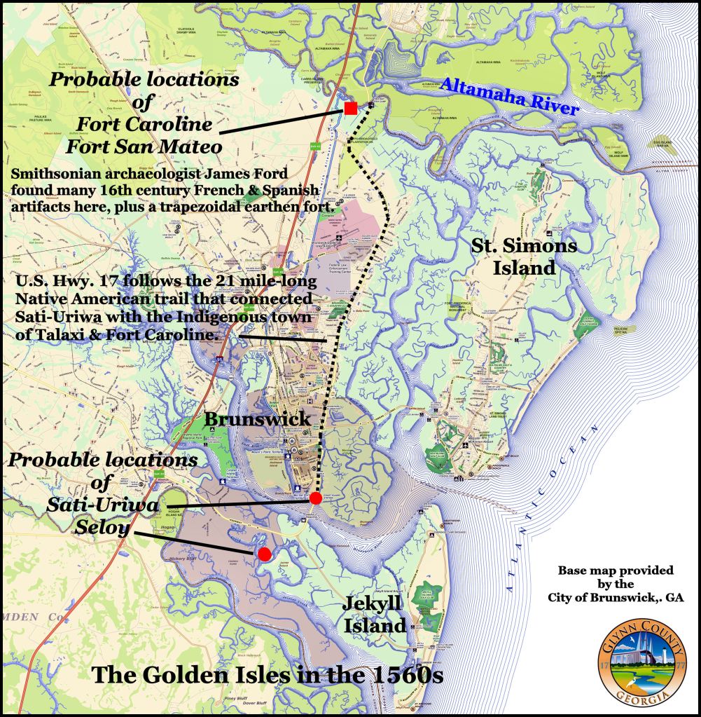
The site of the capital village of Sati-Uriwa is near the shipyards and port, so probably has been destroyed. There is a possibility of finding Native American and European artifacts along the Altamaha River, plus in the undeveloped landscape between the Turtle and Satilla Rivers.

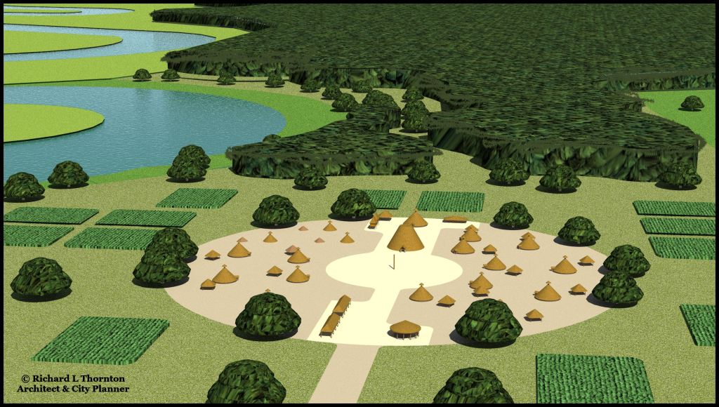
Probable appearance of Sati-Uriwa
Seloy was located on the higher, dryer land between the Turtle and Satilla Rivers. The large tidal creek, next to the village, was more than adequate for meeting the village’s needs.
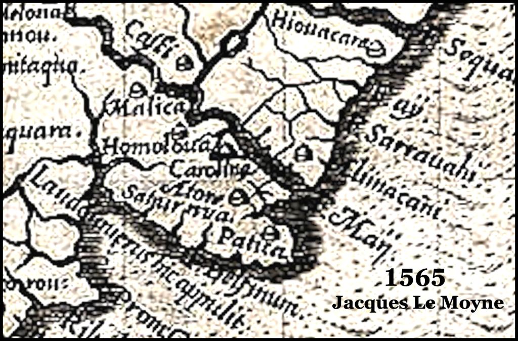
Detail of the 1565 map of Southeastern North America by Jacques Le Moyne, which covers present-day Glynn County. Note that a Latinized version of Satiuriwa is on the southern end of the county, while on its northern end are Fort Caroline and the Altamaha (May) River.

This 1640 Dutch map shows that Seloy appears to be in about the same location, while Sati-Uriwa has moved inland to put more distance between them and the Spaniards. Florida authors typically state that the two Satile villages “mysteriously disappeared after St. Augustine moved to a different location in St. Augustine, FL. There was a branch mission at Seloy until the mid-1600s, which was administered by the friars on St. Catherines Island, GA.
The Basic Facts

Architecture and ethnicity
- Both French and Spanish eyewitness accounts describe indigenous architecture on the Georgia Coast that was typical of the Amazon River/Orinoco River Basins of South America, southern Mexico or Eastern Peru. They were particularly fascinated by the molocas, which were massive A-frame apartment buildings-council houses, which could hold up to 500 residents. By the way, I am an Eastern Creek. All of my Native American DNA markers are from southern Mexico and eastern Peru!
- Museum and archaeological websites tend to portray the South Atlantic Coast structures as being all similar and of primitive construction. In fact, there was considerable variety among the ethnic groups.
- The Georgia Coast was obviously settled last by many small bands of immigrants. Their languages include Chontal Maya, Itza Maya, Panoan (Peru), Peruvian Arawak, Amazonian Arawak, Orinoco Arawak, Tupi, Mexica (Nahua), Taino, Carib and Archaic Polynesian.

1584 Map by Geronimo Chaves – The Spanish assumed that the St. Johns River was a lake that flowed into the Okefenokee Swamp Basin. There were not aware that the St. Johns River flowed into the Atlantic Ocean until 1722, when Col. James Moore of South Carolina used Creek Indian spies to determine that the river’s only outlet was a saltwater marsh, which now a river channel.
The St. Johns River
- The entrance to the St. Johns River was not accessible to ocean-going vessels until 1860 . . . after almost four decades of dredging by the U, S. Army Corps of Engineers. The famous explorer and trader, James Adair, wrote that in the early 1770s, he and a Creek friend attempted to enter the St. Johns with a dugout canoe. Even at high tide they were forced to get out of the canoe and push the canoe for over a mile.
- No French or Spanish sailing ship could have entered the St. Johns River in the 1560s. It is doubtful that even a 16th century rowboat could have entered the channel. There is absolutely no possibility of Fort Caroline or the original St. Augustine being on the St. Johns River. The idea of Fort Caroline being there began as real estate marketing scam in the 1849s by a transplanted New York real estate speculator.
The First “Thanksgiving Service” in North America
- Gov. Pedro Menendez stated to King Filipe II that on September 2, he allowed the fleet to anchor in an estuary of an island at about 30 1/2 degrees latitude (Amelia Island, FL). Most of the colonists and soldiers were allowed to disembark after their long journey across the Atlantic. They socialized with the locals . . . but some of his soldiers at this “Christian Thanksgiving” service stole the gold ornaments of local Indians after getting them drunk on wine. They had to beat a hasty departure to the ships.
- A wide variety of websites, including the National Park Service site, state that after the fleet reached about 30 degrees latitude, the flagship of of Menendez led them into St. Augustine Bay on September 8, 1565, where they held a religious service and dined with the Indians.
FACT CHECK: It was impossible for transoceanic galleons, including Menendez’s flagship, to enter what is now called St. Augustine Bay. This is why he initially planned to only build a small fort at the entrance to the bay and why the town never really prospered. In 1586, led by the English privateer, Francis Drake, a fleet of 23 ships and about 2,000 men attacked St. Augustine. Many of the English warships could also not enter the harbor and so the English were forced to land in rowboats and attack the town by a land route.
- In his letter to King Filipe II, Menendez stated that his flagship and a few accompanying ships arrived on September 7 at the village of the king, which was at 31 1/2 degrees latitude. That is the approximate latitude of Brunswick, GA.
- They took control of the village. As more ships arrived that day and the following days, they unloaded and moved into the village. On September 8, he led a ceremony in which they claimed all of North America for King Felipe II.
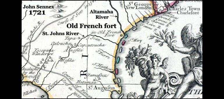
This was the last map to mention Fort Caroline or “an old French fort.”
Location of Fort Caroline
- No official map, published before 1951, showed Fort Caroline being located in Florida.
- All Colonial Era maps, which mentioned Fort Caroline, placed it on the South Bank of the Altamaha River in Georgia.
- In his letter to King Filipe II, Menendez stated that the French fort was located about five leagues (20.8 miles) north of the Indian king’s village. It was situated a little more than 31 1/2 degrees latitude and five leagues (13 miles) from the Atlantic Ocean. That is exactly where the former commander of Fort Caroline, Rene Goulaine de Laudonnière, placed the fort in his memoirs.
- Most websites and books don’t mention what the eyewitnesses said about latitudes. If they do, they will falsely state that Menendez wrote that St. Augustine was about 30 degrees latitude as is that city today.
- However, a group of University of Florida professors thought they would be clever, when creating a website on the founding of Spanish Florida. They posted all of Menendez’s letters to the king in both Spanish and English. The Spanish versions were correct. However, they substituted “a little more than 30 degrees latitude” for “a little more than 31 1/2 degrees latitude” in the Spanish text. The actual latitude of the Fort Caroline National Memorial is 30.38 degrees.

This map of the Southeastern states was published in 1794 and 1795. It is accessible and downloadable online!
Now YOU know!
