
The St. Johns River was never accessible by transatlantic vessels until 1860!
Until United States Army and Navy engineers began dredging the channel in the 1820s, at low tide the channel was only about 30 feet wide and a foot or less deep. It was about six feet deep at high tide. The first goal of the engineers was to make the entrance to the river sufficiently deep (4 feet – 1.2 m at low tide) to allow entrance of shallow draft, coastal paddlewheel steamers.
According to precise drawings by the U. S. Army Corps of Engineers in 1853, 1856, 1857 and 1860 . . . Even as late as 1858, the entrance channel was only seven feet deep at low tide. Until the early 20th century, a two-mile-wide tidal marsh separated the St. Johns River from the site of a 1/12th scale model of Fort Caroline, built by the National Park Service in 1961 & 1962.
The Many Peoples of the South Atlantic Coast Series
by Richard L. Thornton, Architect & City Planner
For most of the time that Spain owned Florida, its leaders assumed that the St. Johns River was essentially a lake that flowed into the Okefenokee Swamp, thence to either the Atlantic Ocean or Gulf of Mexico via the Satilla, St. Marys and Suwanee Rivers. When Spain ceded Florida to the United States in 1821, the river looked like a stagnant lake . . . akin to the appearance of the Okefenokee Swamp today.
However, American politicians and entrepreneurs saw potential wealth resulting from the dredging of a river channel though tidal marshes to the Atlantic Ocean. The US Army Corps of Engineers and the U.S. Navy have been altering the river basin ever since then to make it into a major international port.
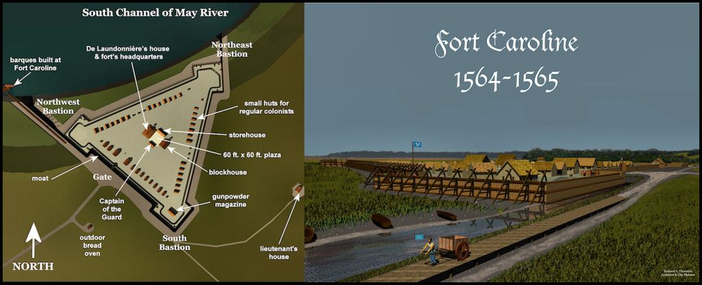
This is what the real Fort Caroline looked like . . . based on descriptions and dimensions furnished by Captain René Goulaine de Laudonnière, Commander of the colony. It was actually a fortified town, sufficiently large to hold over 1,000 residents. The French ships could anchor and unload at a wharf about 50 meters from its walls. This would have been impossible at the Fort Caroline National Memorial, since neither the French nor the Spanish ships could have entered the St. Johns River, plus two miles of marshes would have separated the fort form the river.
The Altamaha River in Georgia was named the May River until 1721, when South Carolina claimed it and renamed it the “King George River.” As late as 1721, the ruins of Fort Carolina were noted on maps as being on the south side of the mouth of that river. As late as 1795, regional maps noted that the former name of the Altamaha or King Georgia River was the May River. Many 15th century French and Spanish artifacts have been found on the south side of the Altamaha River . . . none at the mouth of the St. Johns. This strongly suggests that the Fort Caroline National Memorial is in the wrong place.
Drafts of ships in the past
Draft is a term used by naval architects to describe the proportion of the ship or boat that is normally below the surface of water. This is what my Naval History textbook says:
The draft of a typical Spanish galleon in the late 1500s was approximately 10 to 19 feet (3 to 5.8 meters). Since the sands along the South Atlantic Coast were constantly shifting, it was dangerous to sail in waters anywhere close to those distances.
Armed French and English merchant ships in the 1500s were somewhat smaller than the galleons. Most French ships at Fort Caroline probably had drafts of from 8 to 16 feet (2.4 to 4.9 m). Those depths were still to large to enter the St. Johns River in that era. The French also brought along barques for exploring the tidal creeks and inland rivers. They probably had drafts of around three feet (1 m).
In 1777 the Patriot government in Georgia dispatched three, heavily armed, galleys to attack the British on the St. Johns River. These boats, powered by both sails and oars, were designed to skim over tidal marshes at high tide, yet were unable to enter the mouth of the St. Johns River at high tide.

The George Washington – constructed in Wheeling, VA in 1816
Coastal paddle-wheel steamers began serving Jacksonville, FL around 1827, when the George Washington made the first steamboat visit. It had a draft of 4 feet (1.2 m). Regular service was established by 1830, but most coastal steamers could only enter the river at high tide. The St. Johns River soon became a major hub for riverboat transportation . . . but still could not be accessed by transatlantic ships.
A typical trans-Atlantic merchant ship in the mid-1800s had a draft in the range of 14 to 24 feet (approximately 4.2 to 7.3 meters), depending on the specific ship design and the amount of cargo it carried. They absolutely could not enter the St. Johns River.

1857 Map of the entire mouth of the St. Johns River by US Army Corps of Engineers
The project that opened up Jacksonville to the world
Twenty-five years of piecemeal dredging had failed to open the St. Johns River to international commerce. Strong ocean currents and periodic hurricanes repeatedly deposited sand bars at its mouth, which created a massive sand bar at its mouth. Congress was persuaded to allot major funding and skilled military engineers to the project.
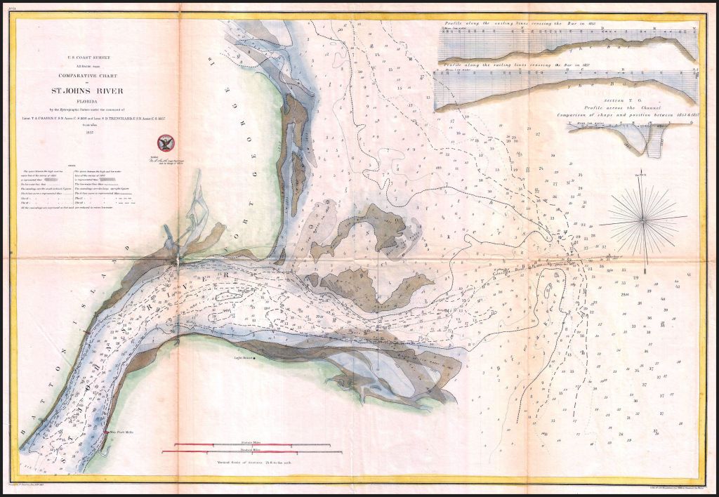
The 1857 engineering drawing for opening up the St. Johns River to international commerce
The engineers realized that the sand bar would return and again until sufficient water volume was created to wash it out to sea. They decided to remove a 20 feet deep layer of sediment at the mouth with the largest dredging equipment available in the United States. With smaller dredges they removed impediments to drainage upstream. They also began the process of removing tidal marshes and then using that soil to raise the elevation in the region, where Jacksonville was expanding.
The project worked . . . just in time for the Civil War to begin. Union troops initially occupied Jacksonville in early 1862 then permanently occupied the city in April 1862 at St. Johns Bluff. This is where New York transplant and real estate speculator George S. Fairbanks had believed was the location of Fort Caroline. Later generations saw the remnants of breastworks and artillery redans from the Civil War and assumed that they were the ruins of Fort Caroline.
Today, the entire channel of the St. Johns River between the Big Bend in the river near Jacksonville to the Atlantic Ocean is man-made. Five hundred years ago, it would have mostly been tidal marshes. Contemporary residents of the Jacksonville Area see a broad river more like a lake than a typical river in the South, They assume that it was logical for France to establish a colony there.
Now you know!
