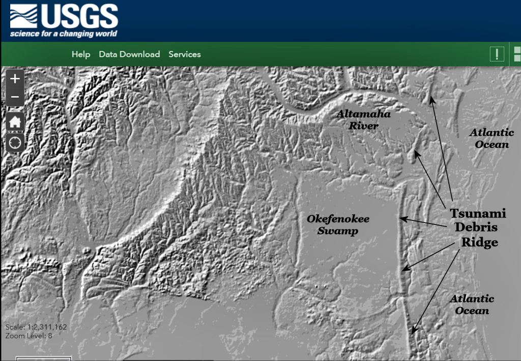
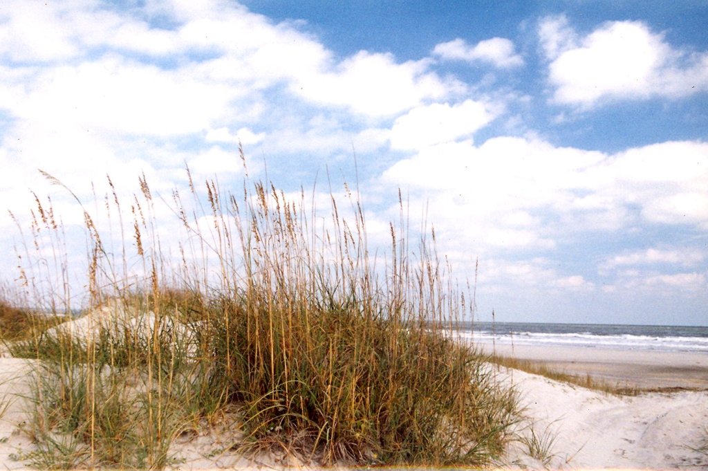
Particularly between St. Marys Sound and the Altamaha Delta, massive ridges and sand dunes can be found up to 16 miles (26 km) inland and up to 85 feet (26 m) tall.
Sand dunes on the northern end of Amelia Island, FL and on Cumberland Island, GA to the north can reach up to 60 feet (18.2 m). Most of Cumberland Island’s dunes are at least 40-50 feet high, Those on Amelia Island diminish considerably as one travels southward on the island.
The Sea Peoples of the South Atlantic Coast Series
by Richard L. Thornton, Architect & City Planner
The massive 536 AD tsunami on the coast of Georgia was caused by the impact of a large comet near the coast of east central Florida that entered the atmosphere from the south at a low angle. The comet’s impact created Cape Canaveral and obliterated Florida’s coastal islands from there northward to Amelia Island. The 85 feet high ridge immediately west of Darien, GA was created by this tsunami, but was originally well over 100 feet tall. The tsunami wave would have been in the range of 145=200 feet tall.
Unanswered questions about the Atlantic Coast’s geological past
At the current time, I have more questions than solid answers as to how former sea currents, mega-hurricanes and tsunamis affected the peopling of the South Atlantic Coast. Twentieth century geologists decided that the numerous sand ridges and dunes in Southeast Georgia and Northeast Florida were created gradually by the retreating ocean, prevailing winds and large hurricanes as the shore of the Atlantic Ocean retreated from its highest elevation . . . which is now called the Fall Line in the Southeast.
I strongly suspect that the shell rings, built on the Georgia and southern South Carolina coasts between around 2500 BC and 1800 BC were a defense against either tsunamis or hurricanes far more violent than today. Hurricanes are a less likely factor because the same region today is typically bypassed or brushed by hurricanes today. That region was the most densely populated section of the North America’s Atlantic Coast in 1500 AD.
I also strongly suspect that there were a several “extinction event” tsunamis that wiped out all or most humans on the South Atlantic Coast, making it open for settlement by maritime wanderers from faraway. The only really strong evidence for this supposition was the sudden abandonment of Swift Creek Culture villages in Southeast Georgia about that same time as the gargantuan 536 AD tsunami..
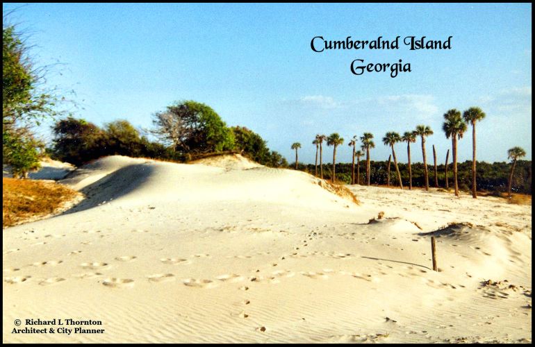
The significance of sand dunes
“Official” references tell us that the enormous dunes on Amelia Island and Cumberland Island were created by large hurricanes. Yet the region between St. Marys Sound and the mouth of the Altamaha River is the least likely location south of Maine to get a direct hit from a major hurricane. For that matter, there is no record of a Class Five hurricane creating 60 feet high sand ridges anywhere.
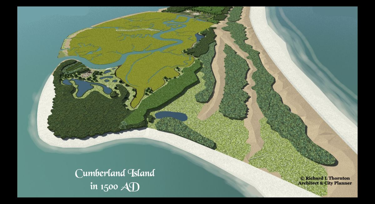
There is another odd thing, which no one has addressed. The sea level of the Atlantic Ocean has been increasing for 18,000 years, yet the oldest part of Cumberland Island is its western side. The island is growing eastward and southward, even though the rise in the ocean has accelerated in recent decades. The three large sand ridges that you see in the computer model at the top of this article, were each deposited at one time. They did not grow by slow, accretionary layers of sand. Three, times, “Something” piled massive amounts of sand on the island.
The Atlantic Ocean’s highest long-term sea levels occurred during the Cretaceous Period (approx. 130–140 million years ago) due to rapid sea-floor spreading. The lowest levels occurred during the Late Triassic/Early Jurassic (approx. 200 million years ago) during its formation, and during the Pleistocene Epoch (Ice Age), when levels dropped 120–130 meters (400-426 feet) . . . 18,000 years ago. At the time, the seashore in Georgia was located roughly 75 to 95 miles (120 to 150 kilometers) east of its current position.
A complex and mysterious geological past
In 2014, a team of geologists, oceanographers and archaeologists from the United State Geological Survey re-examined the geological history around the Kings Bay Navy Nuclear Submarine Base. It is immediately west of Cumberland Island. The primary question to be answered was “how will rising ocean levels affect this important naval base?” There was also a question about the potential for tsunamis at that location.
The USGS team stopped by my former cabin near Dahlonega, GA to get my autograph on their copies of Fort Caroline . . . the Search for America’s Lost Heritage. My book theorized that 85 feet tall Dry Ridge near the probable site of the fort in Georgia was created by the 536 AD comet strike. Their field work confirmed a high probability of that being true. It had all the hallmarks of a catastrophic comet or asteroid impact.
The team, however, was surprised to find several types of sand ridges. [1] Some are parallel to the ocean like those on Cumberland. [2] Some were essentially modest terraces like one would expect to see as a ocean was receding [3] Some were not parallel to the seashore. They were typical of what you see after an earthquake triggers a tsunami. Earthquake tsunamis have much flatter waves than those cause by asteroid and comet impacts. The ocean water is pushed up rivers and estuaries. Their debris ridges are more modest and tend to appear along the banks of rivers and former estuaries.
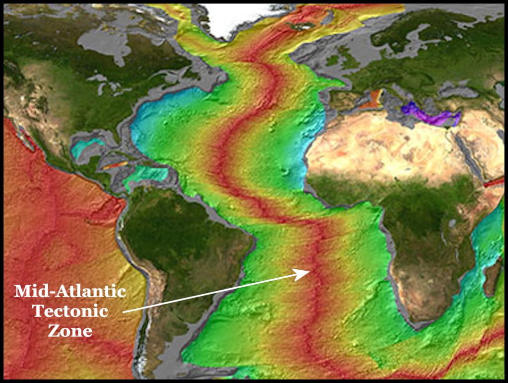
The Mid-Atlantic Ridge (MAR) is the most likely source of a major tsunami striking the South Atlantic Coast. It is a 16,000-kilometer-long, north-south running underwater mountain range and volcanic system in the Atlantic Ocean. As a divergent plate boundary separating the Eurasian/African plates from the North/South American plates, it is a constant source of volcanic and seismic activity, with sub-sea eruptions creating new seafloor
Recent high resolution sonar mapping along the underwater approaches to the Kings Bay Submarine Base has revealed a previously unknown canyon that parallels the edge of the Continental Shelf, plus “holes” which are substantially deeper than the surrounding ocean floor. These are a particular concern to the U.S. Navy, because enemy submarines could hide in them and evade detection. It is currently not known if these recessions represent fault lines.
It was speculated that the diagonal tsunami debris ridges in southeast Georgia were created by earthquakes or volcanoes in the Caribbean Basin. It is conceivable that an earthquake or landslide in the Caribbean Basin on the scale of the 2004 Christmas Day earthquake on the coast of Sumatra could produce a major tsunami of the Florida and Georgia Coasts. The 2004 Sumatran earthquake’s tsunami killed people 5,000 miles away. Cumberland Island is about 1500 miles from the nearest large volcano in the Caribbean Sea.
Fossils and Native American artifacts, where they shouldn’t be
Twentieth century academicians decided that all of the sand ridges in southeaster Georgia and northeastern Florida were the result of the gradual subsidence of the ocean after the Cretaceous Period, but did not do archaeological or geological excavations to test their theory. Outside of Savannah, the Georgia Coast has had surprisingly little archaeological study since Clarence Bloomfield Moore pilfered its most obvious burial mounds in the 1890s.
Megalodon teeth are periodically discovered along the coast of Georgia and on Cumberland Island. The Megalodon Shark (Otodus megalodon) lived 23 to 3.6 million years ago. Yet, Native American artifacts, even potsherds are randomly found in sand ridges father inland. So are the fossilized bones of mammals that lived after megalodon and animals, who lived before megalodon. This could only be possible, if rapidly moving ocean waters scooped up artifacts and fossils on the sea coast and carried them inland. The USGS team found both fossils and artifacts in the soil removed from test pits dug into sand ridges at several locations. These chronological mismatches are also found by amateur artifact hunters in the coastal sand ridges and the ancient sand dunes farther inland.
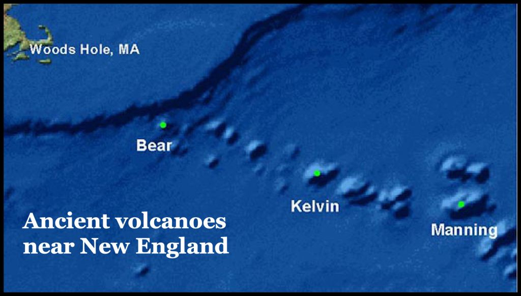
Volcanoes near New England
The New England Seamounts are a chain of over 30 extinct, underwater volcanoes located in the North Atlantic Ocean, beginning a few hundred miles off the coast of Massachusetts and extending over 1,000 kilometers (600+ miles) eastward. Formed 83–103 million years ago by the New England hotspot, these mountains rise up to 2.5 miles from the seabed.
Location: They extend from the edge of Georges Bank southeast toward the Bermuda Rise.
Formation: They were created as the North American Plate moved over a “hotspot” (a stationary plume of magma), similar to how the Hawaiian Islands were formed.
Status: All of these volcanoes are extinct and submerged, with peaks located a kilometer or more below the ocean surface.
Major Peaks: The chain includes Bear Seamount, which is the closest to the coast.
History: The hotspot that created them also formed the White Mountains in New Hampshire and the Monteregian Hills in Canada before moving offshore. While these offshore volcanoes are extinct, researchers have identified a “hot spot” of warm, molten rock deep in the mantle beneath New England, but this is not considered a threat for near-future eruptions.
