Unraveling the Pre-Columbian Past of the South Carolina Low Country – Part One
Etymologies
Sante is a Chontal Maya word, which means “colonists.” The equivalent Panoan word from Peru, which was used in the Georgia Coastal Plain is “Sati”. Satipo, the name of Indigenous provinces in Peru, Georgia and extreme eastern Tennessee, means “Colonists-Place of.” Satipo Province in southeast Georgia also went by its Uchee name of Satile, from which the Satilla River’s name was derived.
Interestingly enough, the Indigenous province in extreme western North Carolina, between the Great Smoky and Snowbird Mountains was named Santetla, from which Lake Santeetlah gets its name, combined the Chontal Maya word for “Colonists” with the Aztec suffix for “tribe or people.” This would seem improbable, except that I found an Aztec-speaking province around St. Marys Sound and Cumberland Island, Georgia, plus some Aztec words on the South Carolina Coast. The province immediately east of Santetla was named Chiaha, a pure Itza Maya word from Chiapas State, Mexico.
Kofitacheki (Cofifitacheque in Spanish) is a pure Muskogee Creek word, meaning “Mixed People – Descendants of – Tribe.” Talikmekko is a pure Chontal Maya word, meaning “Capital town.” Katapa (Catawba) is an Itza Maya word, meaning “Crown – Place of.” Aparachikora (Chicora in Spanish & Chicola in French) is an Panoan and Carib word, meaning “From Upper Amazon Basin – Descendants of -Tribe.” Etallian (Etiwan in English) is a Chontal Maya word meaning “Principal Towns.” This tribe was located on Charleston Bay.
The Sea Peoples of the South Atlantic Coast series
by Richard L. Thornton, Architect & City Planner
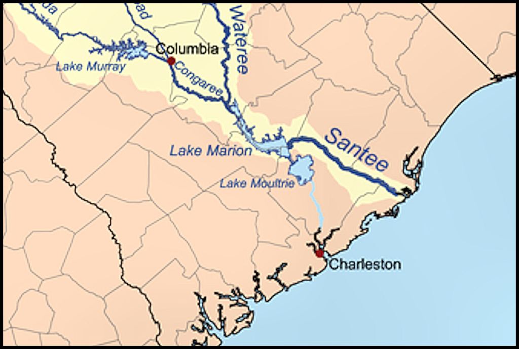
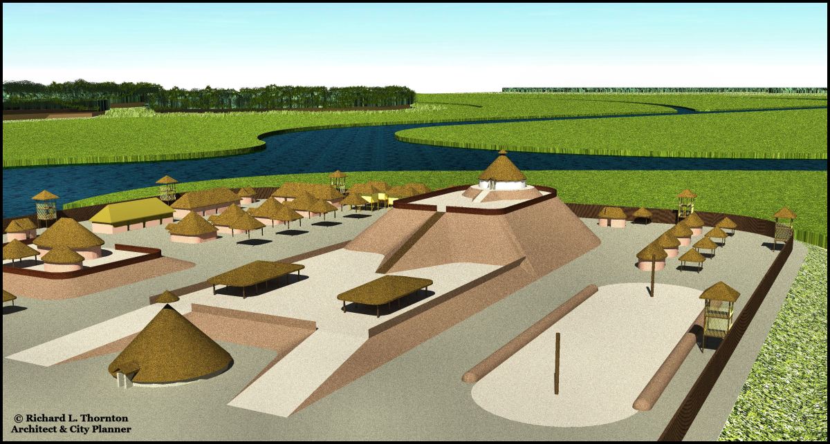
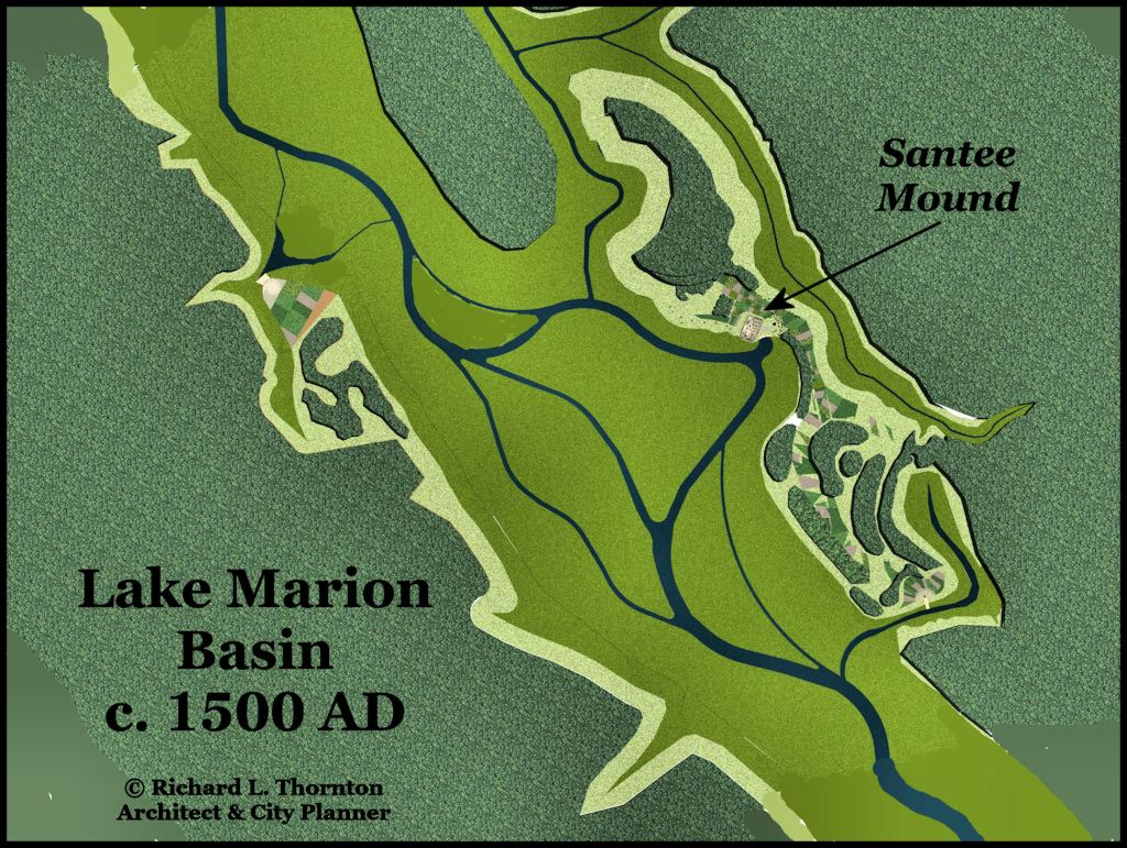
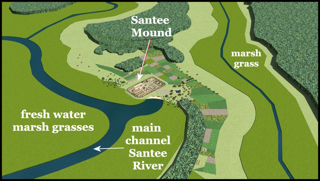
Two months of work were required to create a computer model of the Santee Mound town site and the Santee River Basin, where Lake Marion is now located, as it appeared in 1500 AD. What is really unique about Lake Marion is that it was already a fresh water marsh, which was navigable by Native American canoes and Chontal Maya sea craft. Along with St. Marys Sound, the mouth of the Altamaha River and the lower Savannah River, this region appears to be one of the locales where advanced indigenous cultures spawned.
References
This unraveling of the South Carolina Low Country’s past would have been almost impossible without the memoirs by Captain René Goulaine de Laudonnière, Commander of Fort Caroline (1574), Journal by John Lawson of his 1700 AD canoe journey up the Santee River, and Indians of the South Carolina Low Country 1562-1751 by Architectural Historian Gene Waddell [1980]. Waddell’s remarkable 500+ page book began as a thesis. As for the detailed information on the region’s indigenous peoples contained, there is nothing like it in the Americas.
- Trois Voyages (Three Voyages) by De Laudonnière was translated into English by Richard Hakluyt and is available online. Three Voyages by Charles E. Bennett is not an acceptable resource. He intentionally left out the third voyage by Dominique Gourgues, which provided precise latitudes for the real location of Fort Caroline, the French fort near Midway, GA, the original location of St. Augustine and the locations of the Spanish forts on the Altamaha River. Bennett also redacted all statements by De Laudonnière, which described the May River beginning near the Appalachian Mountains and flowing southeastward to the Georgia Coast or Fort Caroline’s latitude being identical to that of the Altamaha Rivers mouth.
- Lawson’s Journey through the Carolinas and Waddell’s Indians of the Low Country have been reprinted and can be purchased.
Maps: I utilized historic maps, published by the State of South Carolina and United States Geological Survey prior to the construction of Lake Marion, to place the locations of river channels in colonial times. I utilized a LIDAR scan by the United States Geological Survey as a base map for constructing the three dimensional computer modal.

LIDAR scans read the water surface as flat land, so older maps must be used to describe channels.
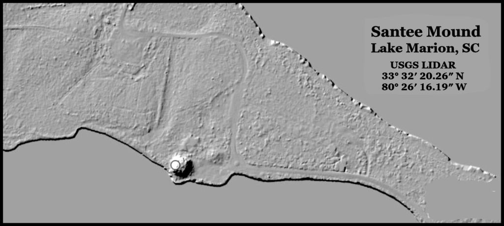
A more detailed LIDAR scan located the three mounds on the town site.
Historic Terrain Modifications and Vegetation: Documents online, published by the State of South Carolina described alternations to the mound and environs, when it was converted into a British fortification (Fort Gibson) during the American Revolution. Others described particularly destructive floods that occurred on the Santee River during the 1800s and 1900s, after much of the tree cover was cleared to develop plantations. These floods chopped off the semi-circular southwest facade of the mound, plus cut a channel through its northeastern platform.
Being heavily “into historic preservation” the State of South Carolina, plus the schools of Historic Preservation and Landscape Architecture at Clemson University provide excellent references for insuring the correct combination and appearance of natural vegetation in the state – including the vegetation on the Santee River prior to extensive cultivation by European planters.
In our next article, we will explore the town of Sante . . . also known as Tallimekko.
