Why the seemingly gentle South Atlantic Coast of North America is actually a graveyard of ships. At St. Marys Sound, the coastal waters are extremely difficult to navigate on because of the flat terrain and seven feet (2.13 m) difference between high and low tides. Given the jerry-rigged nature of the two boats that Craig Duvall brought along, it is miracle that we even made it to the island. We take you back with our time machine to August 1971.
by Richard L. Thornton, Architect and City Planner
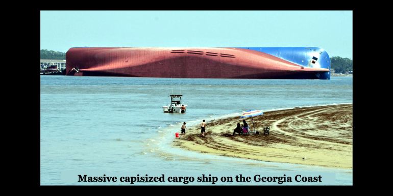
The South Korean cargo ship Golden Ray capsized Sept. 8, 2019, shortly after leaving the Port of Brunswick, GA , about 9 miles (14.5 km) north of Cumberland Island and about 70 miles (113 kilometers) south of Savannah. More than 4,200 vehicles were in the ship’s cargo decks. The ship was dismantled and sold for scrap. How could this be? The ship struck a new sand bar and capsized, despite being equipped with the most modern commercial radar and sonar available.
The South Atlantic Coast of North America was a very dangerous place for 16th and 17th century European explorers to travel, even though there are no rocks or maelstroms. The Continental Shelf slowly deepens the farther you are east of the coastline, but sometimes a sand bar will temporarily appear anywhere from a quarter mile to several miles off the coast of the South Atlantic Coast’s islands. Most ships were wrecked in the same way as the modern cargo ship above. They became stuck on soft sand in a place where it was not supposed to be.
Unless a sailing ship was struck by a hurricane, most crew and passengers generally survived the offshore grounding of a ship. The ship was quickly toppled onto its side by waves or wind, but the occupants usually still had time to put out boats that could be paddled to shore. Seamen could even ride the floating wreckage of ships to a nearby beach.
It was a very different world than today back in the early 1970s for sailors on small boats, even though the communities and houses that we live in have changed very little. Communications were incredibly slower. Fuzzy black & white satellite images of major storms were shown on TV weather forecasts, but typically they did not reach our TV weathermen until after the storm front or hurricane had already passed your community! The night before we left for the Georgia Coast, the TV weatherman told us that a hurricane off the southern tip of Florida had turned northeastward toward open ocean.
The US Geological Survey and US Army Corps of Engineers DID publish very accurate nautical and topographic maps of the South Atlantic Coast. On their backs were the tidal charts that told sailors when high and low tides would occur each day, plus the maximum and minimum sea levels. HOWEVER, I did not learn about the trip to Cumberland until the end of the first week in August.
In 1971, very few “regular folks” had general purchase credit cards, although gasoline credit cards were becoming more popular. College students couldn’t get either, but it didn’t matter. All long-distance purchases were by check or US Post Office money orders.
Local check purchases took about three weeks to show up in your own checking account. It would have taken over a week for my check to arrive in first class mail to Washington, DC. The additional time for the government agency to open the letter, deposit the check in their bank, my bank receive the parcel containing the check from Washington, DC and that check to clear would take about six weeks. As much as a month might be required for the USGS or USACOA to package my map and for it to arrive in the Atlanta Area. So . . . if lucky . . . a map ordered in early August would have arrived in mid-October.
SLIDE SHOW
I am going to present those halcyon days from long ago as we experienced them. Just like exactly a year earlier when I was in the Yucatan Peninsula, we had no clue where we were while sailing to Cumberland or while camping on Cumberland. We did not have detailed nautical maps or satellite photos. I brought with me a state highway map, a Xerox copy (1970s word for photocopy) of a map drawing by a state draftsman of Cumberland Island and a Xerox copy of the street plan of downtown St. Mary’s, Georgia. That’s all. You will have to look Cumberland Island up on Google Maps!
Exactly 48 hours before I was sitting by a campfire in the jungle of Cumberland Island, I was sitting beside a man, who in five years would elected President of the United States. That’s how we will be begin.
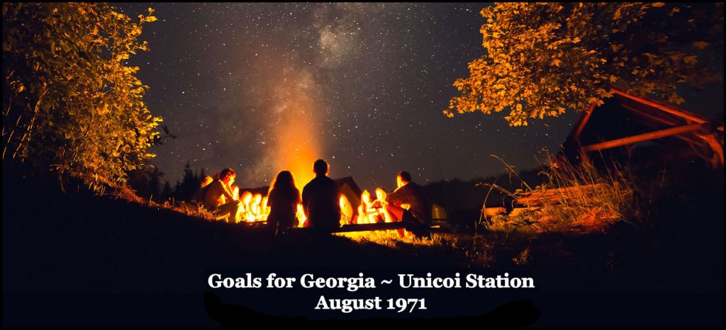
Governor Carter invited his first group of interns to the recently completed lodge at Unicoi Station, near recently re-created Alpine Helen, GA. Unicoi Station is now called Unicoi State Park. This was a working retreat, where he tapped the heads of what was supposed to be state’s future leaders. In the first part of the week, we broke up into our planned professional identities to determine what Georgia would be like in the year 2000. In the second part of the week, we came together to discuss what state projects and programs would be needed by the year 2000.
We got almost everything wrong, except the need for more hiking trails, bike paths, highways, bridges and rapid transit. Policy wise, we proposed one thing right. We urged Georgia to shift to non-polluting sources of energy. The governor immediately adopted alternative energy sources as a policy of his administration. Georgia now produces more “clean” electricity than any state in the union. In parallel, because of the presence of Georgia Tech, the state is also developing into an international center for advanced battery manufacturing and electric vehicles.
No one, even Jimmy, realized what lay in the future . . . such as personal computers, cellular phones, the internet, the Atlanta Olympics, Atlanta becoming the busiest airport in the world . . . and certainly, who would be the next two presidents. In three years, President Richard Nixon would be forced to resign and be replaced by VP Gerald Ford. Then in 1976, the unthinkable would happen.

When some Floridians purchased most of Helen about three decades ago, they replaced the authentic earth tones of the original buildings with inauthentic gaudy colors. This street now has no parking and is lined with shops.
On the last night, we sat around a campfire. Two relatively young men, dressed in blue jeans and flannel shirts, sat on either side of me. One would become President of the United States, the other, “jovial” Jody Powell, would become his White House Press Secretary. Around the circle, a few people down, was Caron Griffin from Hawkinsville, GA. She would achieve brief fame as the first wife of Chip Carter and living in the White House for three years. None of the rest of us became elected leaders, famous or powerful.
St. Marys, Georgia

Entering St. Marys, GA in 1971 was like going through a time machine. The streets were paved with sand. Most of the buildings dated from the 1800s. There were very few people or cars in the dilapidated downtown. I put my Polaroid Black & White camera in Craig’s station wagon, thinking that we would be back in three days. Most of the Polaroid images were fried during the 2 1/2 weeks we were gone.

Along the waterfront were ancient wood structures that dated from the early 1800s. We were shocked to hear a strange foreign language, when we entered the bait. It was Gullah, but I had never heard the term before. The interesting thing was that when the friendly African-American owner switched to English, it was much more precise than what normally heard back then in rural South Georgia. He actually sounded a bit like Scottish.

Two shrimp boats at the dock in St. Marys.

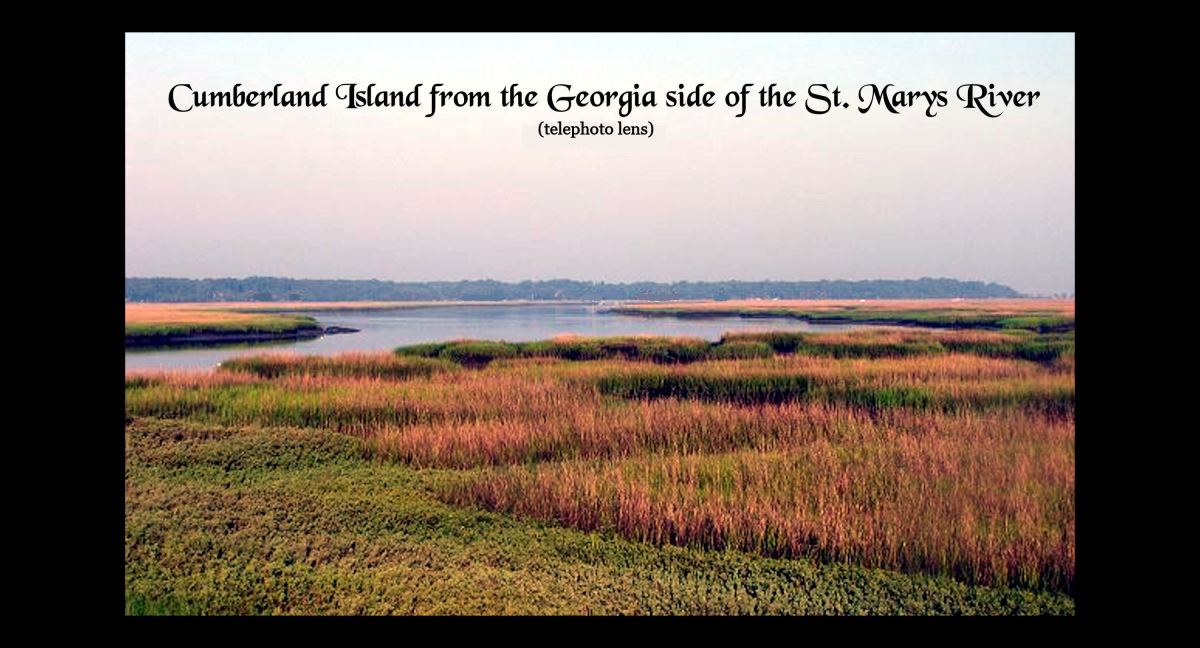
I took this crisp photo in 1998 with a Nikon camera and telephoto lens. In 1971, Cumberland Island was barely visible from St. Marys as a thin gray line. At the time of this photo, Intelligence Officer Susan Karlson and I were celebrating seven years of being friends with benefits, by me showing her Southeast Georgia, where I was born. While we attended church together at Roswell United Methodist Church in the late 1990s, she posed as a childhood friend from Waycross, GA . . . but had never seen Waycross.
We took the National Park Service ferry over to Cumberland and visited the northern and central portions of the island that I missed in 1971, while camping out near the Dungeness Ruins. The section of the island that I surveyed in 1971 was off limits to the public in 1998.
After I moved to Jasper, GA in 2000, Susan began posing as various women on internet dating web sites, whenever she was back in the United States. Being a pro, she was amazingly skilled at changing her looks with hair dye, make up and clothing.
Upon turning 40 in 2006, Susan planned to take hazardous duty retirement. We were going to move to a historic farm in the northern Shenandoah Valley, where we first met . . . and make our 15 year secret romance, proper and legitimate. LOL Only then could she legally tell me her real name and full identity. I will tell you what happened in another bedtime story.

This is a view of St. Marys, when we were making a sharp turn to the left into the main sound. Woody and I rode on a home-made catamaran that was shorter than my Mad River Voyager canoe! The only thing that kept us from being tossed into the ocean by the waves, was holding onto the mast!
All of my photos, taken from the boat are fuzzy. I had to wrap my left arm around the mast and take a picture with a inexpensive Olympus camera. As you can see, there were two to three feet high waves rocking the catamaran. Sometimes the waves washed over the boat.

Craig showed up at my parent’s house with a motor-less catamaran. He never could get the engine working prior to time for him to leave his parent’s home in NW Atlanta. His solution was to bring along an early version of a “Jet Ski” that he had designed and built for a class in Industrial Design at Georgia Tech. Jet, it was not. It barely had the power to pull the small catamaran . . . it if was running at all. That’s Cumberland Island on the horizon. Note that Craig is sitting cross-legged on a plywood platform, which is only about 6-8″ above the water!
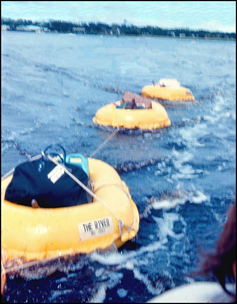
Craig neglected to tell me that there was no place on his little catamaran to store our camping equipment and food coolers! He brought along three one man life rafts to haul everything in. Had there been a big wave or high winds from a storm, we would have lost everything to the ocean.

We thought that we were heading straight for Cumberland Island, but then we realized that there was a labyrinth of marsh grass and tidal creeks between our flotilla and solid land. We had to turn back into the St. Marys Sound and work our way around the marshes until we found the Cumberland River . . . aka the Intercoastal Waterway . . . which would take us to the edge of solid land.

This is a fuzzy view in choppy water as we are about to exit St. Marys Sound and enter the Cumberland River or Intercoastal Waterway. Notice what a low profile the island would have made for 16th century explorers . . . even when fairly close to shore.

THEN Craig’s proto-jet ski’s engine went dead. We literally had to paddle our way into the Intercoastal Waterway, before Craig finally got his motor running. By then it was getting near sunset.
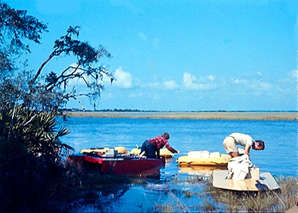
Here is a good photo of Craig’s minuscule catamaran (with its mast down) and prototype, underpowered jet ski, plus the three life rafts. We are unloading the rafts and setting up the camp site. These tiny vessels transported us over seven miles of the St. Marys River and St. Marys Sound. Actually . . . never again would I be so stupid to pull off such a dangerous stunt.

Totally exhausted, we searched the edge of land until we found what appeared to be a small, old Indian mound. We pitched our tents on the mound in the midst of dense Spanish bayonet shrubs then quickly put together some ham and cheese sandwiches for dinner . . . then collapsed asleep.
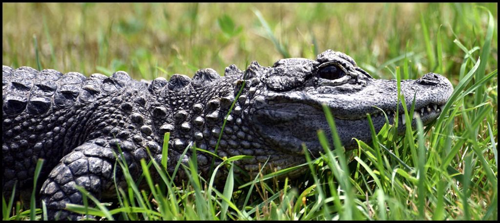
Then around midnight, Woody woke us up. He cursed and asked me what in the heck was making those weird sounds under the ground and out at the edge of the water. I was born in the Okefenokee Swamp, but didn’t want to scare my buddies until I was certain. I shined my electric lantern toward the water and saw pairs of orange eyes, moving around. We had pitched our tents on top of a BIG alligator den!
Tune in next time to see if the alligators decide to have us over for a romantic midnight dinner. Oh, and never going camping next to the ocean on the South Atlantic Coast without a tidal chart!

Fantastic telling of quite an adventure and appreciate all of the little life reminders about mail and maps – former map maker here! And yes, far easier to get to Cumberland a very magical island with St. Mary’s still being sleepy but not as much as when you had the fortune of seeing her so rustic and the destination of few. Did you encounter anyone from Carnigie’s family at Greyfield? All the same as they shout at the opera theater – “MORE! MORE! MORE!”
LikeLiked by 1 person
Those are very kind words coming from a master story teller and cultural icon of his own town. No one was living on the island at that time. All the houses were empty. That was the problem. There was a livable cottage on the grounds of Dungeness. Its the one where the French sailors were buried. We could see through a window that there was non-perishable food stored in its kitchen. Even though we were quite hungry at the time, I didn’t want to break in the cottage, because Jimmy’s last comment was that whatever we did would personally reflect on him. I assume that the cottage was the temporary residence of the regular state employees, who had surveyed most of the island, except the southern tip, where we were supposed to camp.
LikeLike
Why thank you Mr. Thornton we’re both in good company here I’d garner to say and had not realized that you were all the more fortunate then to play Robinson Crusoe on Cumberland! I had good fortune to stay with The Fergusons at Greyfield in the early 1990s when it still felt fairly undiscovered and a times going up near Plum Orchard, could pretend we were in some abandoned world. There’s still a little of that there if you squint. Much respect on leaving food be. Great writing!
LikeLike