
Cofitachequi was the name of a town, visited by Hernando de Soto’s Expedition in the spring of 1540. The story has been romanticized to the point that what most people think know about Cofitachequi was that it was ruled by a queen, who greeted De Soto as he approached her town from the other side of the river. She and her retainers were rowed across the river in a fancy canoe then carried on a litter. The town was probably located in South Carolina, but beyond that what references and academicians tell you today about Cofitachequi has very little relevance to what is said about the town in the De Soto Chronicles. In the meantime, academicians have cited the speculations of the previous generations of academicians so much, that they have taken the story out into lala land. None of them even know what the word means.
About 15 years ago, I attended a symposium, sponsored by the Southeastern Archaeological Conference, at the University of North Carolina at Charlotte. Its theme was “The Spanish Colonial Activities in 16th century Carolina.” My companion (the señorita sitting beside me, who I soon befriended) was a female archaeologist* from Colombia, who was an expert on the Mayas and other Central American civilizations. She wanted to know more about the Spanish Colonial Period in North America. She was the only Latin American at the conference. I was the only Native American. Until we could take it no longer, we listened on Saturday morning to academicians from North Carolina and South Carolina argue as to whether Cofitachequi was a Cherokee town or a Catawba town. The word is Creek! We eventually walked out and spent the rest of the weekend in Asheville and Knoxville.
*Sad news . . . when we re-united the next weekend to tour Ocmulgee National Monument in Macon, GA, she confessed to me that she had taken off her engagement ring at the symposium. She was have a last sow of wild oats, before marrying a rich businessman, who funded her digs.
Family memories
Until age 25, I thought that the Muskogees were the arch-enemies of the Creek people. Family lore remembered a bloody period, probably in the 1600s, in which the Muskogees invaded present day Georgia and initiated a three-way war between the Upper Creeks, Muskogee-speakers and Apalachete-Itstate Creeks. The latter alliance were my ancestors.
The Muskogee speakers won a series of victories, destroying several major towns, until the South Carolina Creeks joined with their brethren on the west side of the Savannah River to fight an apocalyptic battle in Northern Georgia. It was a draw, but resulted in catastrophic casualties on all sides. I suspect that this is the origin of the frontier folklore about Blood Mountain, but it had nothing to do with the Cherokees. In my family’s folklore, the Cofitachequi were assigned a region to settle in and all parties agreed to be members of a confederacy that would prevent future wars. Eight small bands of Georgia Creeks refused to join the alliance with the hated Muskogees and so migrated to the tributaries of the Savannah River. The were called Chorakees, which means “Splinter People.” Several decades later they formed an alliance with the Cherokees. Today, they are known as Lower Cherokees, but they always spoke a dialect of Creek, but by the early 1700s had English names.
Two of my ancestors were minor mikkos, who signed the 1773 Treaty of Augusta. Until then relations between Georgia and the Creek Confederacy had been friendly. Anyone wishing to settle in the ceded Creek territory was supposed to travel first to Savannah to petition for land and be awarded a land patent. First of all, British officials tried to hoodwink the Creeks by running the boundary line farther north to include several thousand more acres. William Bartram observed this scam and wrote about it in his book. Then hundreds of outlaws and people, whom Royal Governor James Wright called “Crackers” sneaked across the Savannah River and “squatted” on royal lands or even built cabins on Creek lands. Governor Wright was quite aware of the horrific impact that these squatters had on relations with the Creeks, but the Creeks blamed the British aristocracy.
In 1776, the Cherokees attacked the South Carolina frontier and did not discriminate between Anglo-American and Creek farmsteads. This was the last straw. The Northeast Georgia Creeks sided with the Patriot cause . . . even forming an all Creek unit, known as the Raccoon Regiment. The original name of Georgia’s Broad River was the Sawakehatchee or Raccoon River. Soon Mixed-blood Tory, Alexander McGillivray took control of the Creek Confederacy and moved its headquarters to British-held, Pensacola, East Florida. He began dispatching Upper Creek war parties to attack Patriot Creek farmsteads in eastern Georgia. The attacks continued on Northeast Georgia Creeks, who spoke Itsate (Hitchiti), until 1794.
As result, many Creeks in the region cut their ties with the Muskogee-speakers and cast their lots with their white neighbors. Children were intentionally married off to whites or other Patriot Creeks to cement political ties.
Former Georgia Trail of Tears President, Leslie Thomas, studied the census records and determined that 20,000+ Creeks and Uchees in Georgia did not move to Alabama and then go on the Trail Tears to Oklahoma. Also, of the 3,000+ Creeks living in the Cherokee Nation, only 800+ went to Oklahoma. Of the 15,000 Creeks who started the Trail of Tears, 3,500 died. A third of the Oklahoma Creek Nation died in the American Civil War. Thus, there are today far more Creek and Uchee descendants among original Georgia Creek and Uchee families than in Oklahoma. Very few of the Creeks and none of the Uchee, who stayed in the Southeast are federally recognized. Your teacher never told you that, did she or he? That is how far off the history books are.

Etymology of Cofitachequi and Catawba
Cofitachequi is the Hispanization of the Muskogee Creek word, Kofitvshi-ki, which means “Mixed (race) people-descendants of – tribe.” What is a Muskogee word doing in South Carolina? All the other Creeks spoke Itsate (Hitchiti) or an extinct language, which contained many Panoan words from eastern Peru. The “ki” means “people or tribe” and is pronounced like a guttural G. This suffix is also found in Irish Gaelic, Algonquian, Shawnee and Cherokee.
The Itsate Creek equivalent to Kofitvchiki is Kofitvshite, written on European maps as Kofitachete. The “te” suffix is Itza Maya. The Kofitachete were extensively discussed by Charles de Rochefort in his landmark 1658 book. He described a war involving the Kofetiachete, which sounded suspiciously like the one in my family’s folklore.
Catawba is the Anglicization of Katapa. It is an Itza Maya work, which means “Crown – Place of.” The home base for the Katapa was the Chattahoochee River between Atlanta and Gainesville, GA. You can see Kataapa located there on mid-18th century maps. Evidently, one band became the elite of a province composed of Siouans, who called themselves Issa.
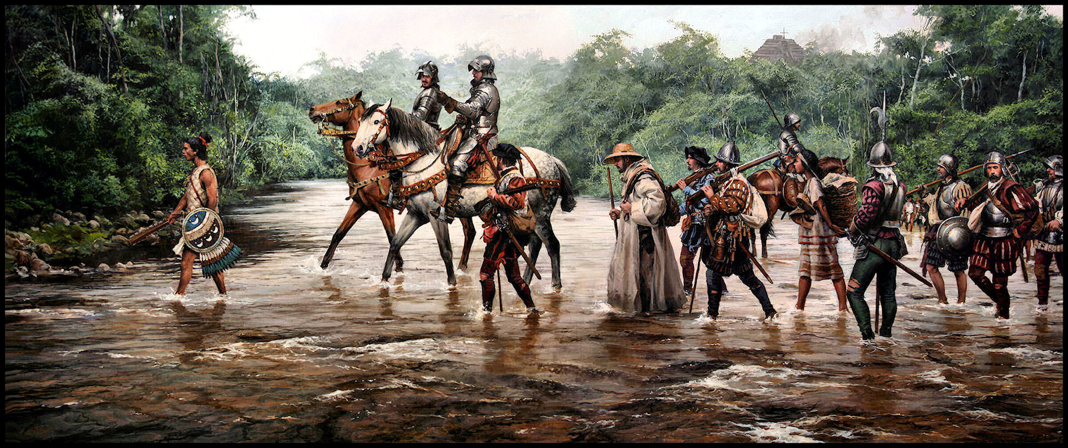
What the De Soto Chronicles actually said
If one browses the internet and references, you will see Cofitachequi as a province visited by Hernando de Soto, which was ruled by a queen. WRONG! First . . . the chronicles state that de Soto was greeted by a relative of the queen of the province, not the queen herself, who lived in a town called Talimiko. That is the Itsate (Hitchiti) word for a provincial capital. The equivalent Muskogee word is Etalwamiko. Cofitachequi was described as being two days walk from the sea. The town site that Wikipedia tells you is the former location of Cofitachequi is 110 miles from the Atlantic Ocean.
The queen described Cofitachequi as an enemy town that had recently been abandoned because of plague. She said that several towns and villages in the region had been abandoned because of a plague. She invited the Spaniards to dig up the graves of the enemy dead to rob their pearls.
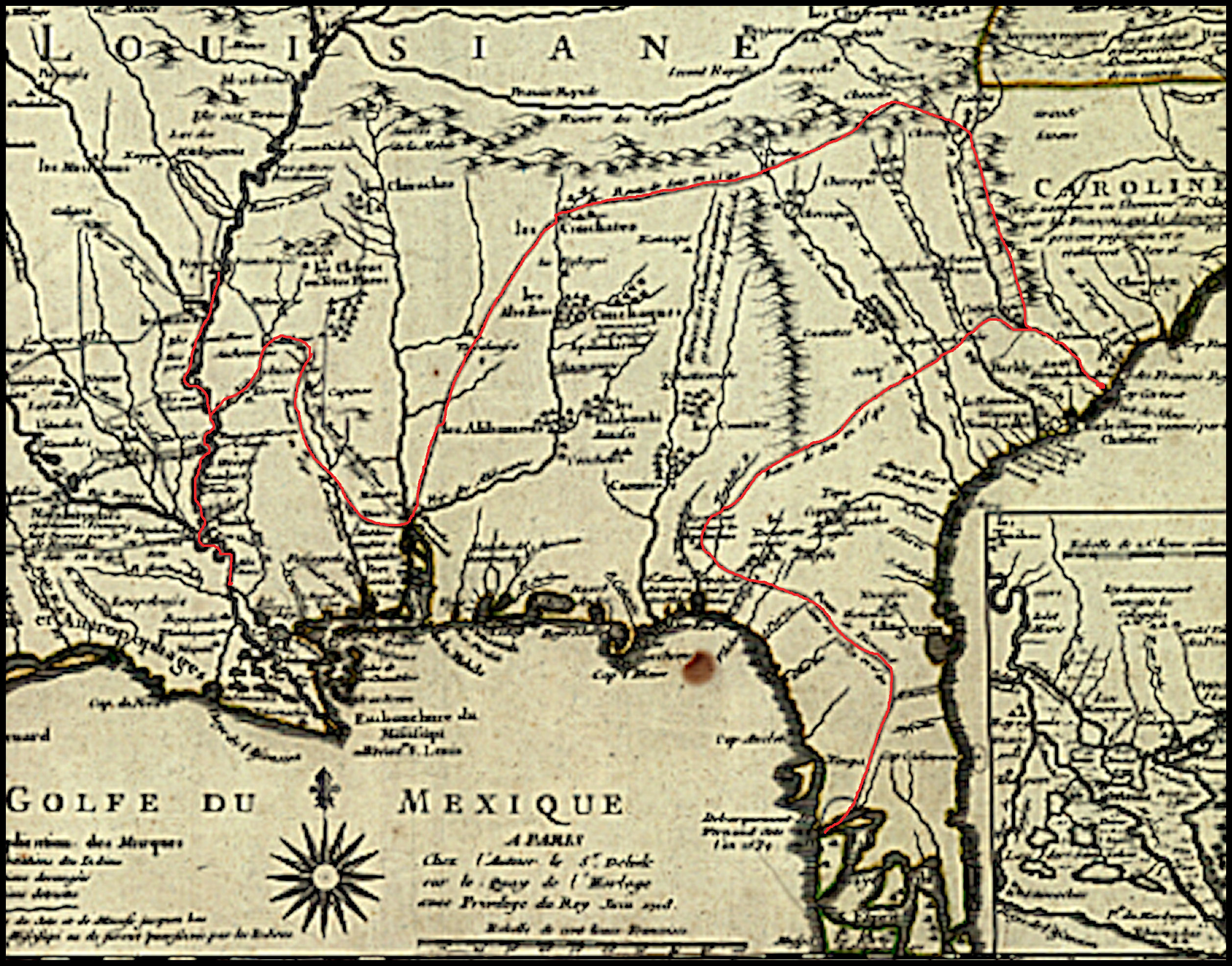
Now, these are the places that a group of late 20th century anthropology professors royally screwed up. Cofitachequi and Chiaha are the only two Native American towns visited by both De Soto in 1540 and Juan Pardo in 1567-8. While I was Director of the Asheville-Buncombe Historic Resources Commission, we told the professors that there were no occupied towns on the Lower French Broad River during the early and mid-1500s. They ignored us. The professors put Chiaha on an island in the French Broad River that in no way matched the description of Chiaha. Three major rivers converged jus upstream from the real Chiaha. Then . . .
They placed the Cofitachequi of De Soto in the same place as the Cofitachequi of Juan Pardo, plus placed that town 110 miles from the coast rather than around 24-30 miles that a two day’s walk would entail. All references describe the impossible location of Cofitachequi as unquestionable fact. The professors then used that faulty locations of Cofitachequi and Chiaha as a bench marks for charting the routes of both De Soto and Pardo! Incredible!
Subsequent generations of PhD candidates and academicians have written a legion of dissertations, academic papers and books, whose starting point was based on the faulty speculations of those professors. Most of the papers and books try to answer the question, “What happened to the province of Cofitachequi? It was there when South Carolina was first settled, then it disappeared.” Actually, the academicians equate a small town visited by traders, named Cofitachequi, with a province . . . not knowing the generic meaning of the word. Kofita means “mixed race or mixed ethnic group people.” There was a province by that name between the Oconee River and the Savannah River. The late 17th century Cofitacheque could have merely been colonists from Kofita.
In an earlier article, we told readers that the names of all four of the original Muscogee-speaking tribes . . . the Koweta, Tuskegee, Tokahsi and Kulasi . . . could be found today in the place names of the region between Franklin, Hendersonville, Brevard and Highland, NC. There is even a community named Etowah there. These Muskogee speakers were known for being tall and brawny. The Tokahsi and Kulasi had freckles and sometimes, brown or red hair. They used the Irish Gaelic suffix, gi, for “people or tribe.”
Factual archaeological information is limited for this region, but is described comprehensively in Benny Keel’s 1976 book, Cherokee Archaeology: A Study of the Appalachian Summit. The only three professional archaeological digs on the Tuckasegee River found that the Muskogean towns were suddenly depopulated in the early to mid-1600s then gradually repopulated, beginning around 1720 by Cherokees. Keel states toward the end of his book that he could not label the planned towns as Cherokee, without further evidence. Of course, North Carolina archeologists now label both the formally planned towns with rectangular houses and the random layout of crude round huts, a hundred year later as Cherokee. They also unknowingly used an Itsate-Creek word, Connestee. for the “Cherokees” who lived in Western North Carolina during the earlier Woodland Period.
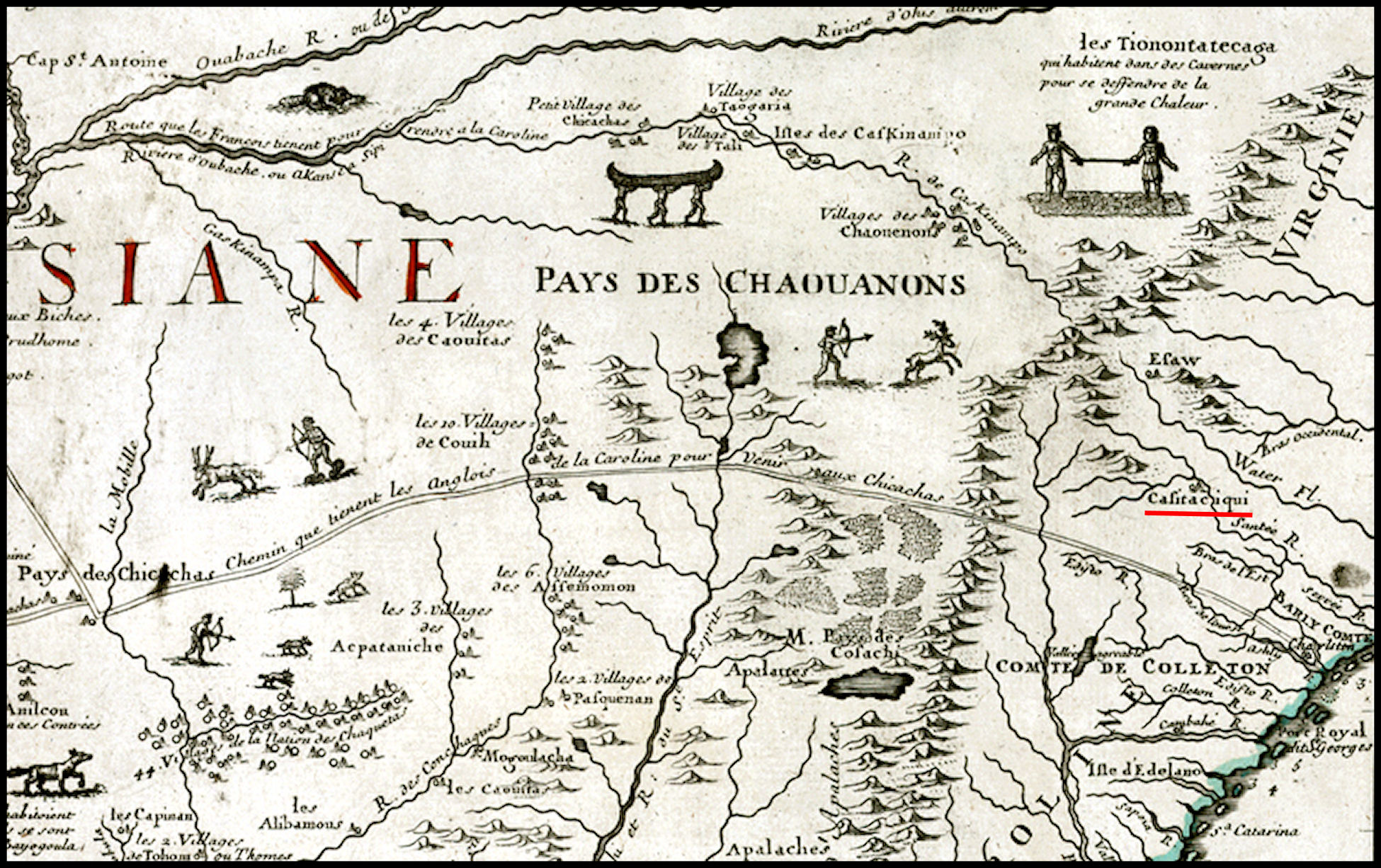
Early Colonial Period maps are not detailed enough to show who lived there, but the 1701 Map of North America by Guillaume De L’Isle shows that exact same area . . . between the Apalachen Mountains of Georgia, the Okonaluftee-Tennessee River and the French Broad River . . . occupied by the Cofitachete. Cofitachete is the name that their neighbors, the Apalachete, called the Cofitachequi.
De L’Isle also correctly placed De Soto’s Cofitachequi about a two days walk from the Atlantic Ocean. Well, the truth is out there somewhere, concerning the ethnic identity of the people of Cofitachequi, but now you know the truth about where De Soto’s men robbed graves to steal pearls.

BYW Creeks are Muskogeans and they did not live at Cofitachiqui.
Linguist Blair A. Rudes dissects Booker, Hudson, and Rankin’s study of sixteenth-century placenames from Cofitachique to Xualla. Rudes uses the term Cofitachique in a broad sense to include all the towns that are supposed to have been part of the Cofitacheque chiefdom, or that were allies. He shows that previous attempts to use recorded placenames to identify the sixteenth-century inhabitants with eighteenth-century tribes have been flawed:
“Previous research on the etymology of place names from Cofitchequi might best be characterized as long on speculation and short on rigor. While etymologies have been proposed for many of the place names, few stand up to careful review. Unfortunately, the weaknesses in prior analyses have not prevented researches from using the results to draw sweeping conclusions about the ethnic and linguistic composition of the area.”
Rudes goes on to suggest that while Booker, Hudson, and Rankin follow John Swanton’s proposal that “Muskogean-speaking people were a major constituent of the population”, a careful analysis of the evidence does not support that conclusion. Though Hudson et. al. put forward several place names in the Cofitachequi orbit as Muskogean, Rudes finds only one to be of Muskogean origin, that of Talimeco/Talomeco. But this name, he argues, is likely not an indigenous place name, but a descriptive name given by a Muskogean speaking interpreter. The name simply means a town wherein a chief resides or chiefs’ town. Therefore, of all the sixteenth-century placenames recorded for towns from Cofitachequi to Guasili, Rudes concludes that none, based on linguistic evidence, appear to have been Muskogean towns.
LikeLike
Actually Carrie, I know helluva lot more about the subject than Mr. Rude does. Neither Hudson nor Rude knew diddlyquat about converting Hispanic phonetics to Indigenous phonetics. I can translate all of the Muskogean languages, plus Itza Maya, Tamulte Maya and Totonac. Hudson didn’t even know how to pronounce Spanish, much less the meanings of Spanish words. I was appalled when he and his fellow professors visited my office in Asheville, NC. Cofitachequi in Muskogee is written Kofitvciki and can be easily translated as Mixed (race/tribe) People. The word Mvskoki (Muskogee) has the same meaning.
LikeLike
If you read this post, I hope you realize it is grossly inaccurate. There were no Muskogean towns on the Tuckasegee River. This is the heart of Cherokee country and has never been in dispute.
LikeLike
Oh should have read this one first. You are wannabe Cherokee. French and Dutch maps show the Cherokees living on the north side of the St. Lawrence River until 1650 AD. The earliest map of the Southeast to even mention the Cherokees was published in 1715, but according to “History of Cherokee People” by Cherokee Principal Chief Charles Hicks (1826) they entered the SW corner of Virginia and the NE corner of Tennessee about the same time as Charleston, SC was founded (1670). The two main bands of the Cherokees did not enter much of western North Carolina until after the Great Smallpox Plague of 1696 had wiped out most of the Shawnee, Creeks and Uchees living there. He said that a small band of Cherokee did arrive near the headwaters of the Tuckaseegee River around 1670. The Xuali (Suala) were a huge, powerful tribe in northern West Virginia until they were wiped out by the 1696 Epidemic. The town of the same name on the NC/SC was a satellite colony of the Xuali. Talameko is a Tamulte Maya word, which means “capital of a province”. It literally means “Town of the king.”
LikeLike