
by Richard L. Thornton, Architect & City Planner
Four years before the remaining Cherokees were forcibly expelled from Georgia, state gold assayer, Dr. Mathew F. Stephenson, led a prospecting party through the higher mountains in search of mineral resources. The Treaty of New Echota had just been signed, ending the official presence of Cherokees in Georgia. One thing is clear, however, the Georgia Mountains had few inhabitants at that time. In 1855, his description of the journey was published in Historical Collections of Georgia by George White. Incredibly, Dr. Stephenson’s naive interpretation of the Track Rock petroglyphs and stone ruins became the basis of a subsequent Smithsonian Institute report and even a professional archaeological report to the United States Forestry Service in 2001!
Background
In 2012, representatives of the Georgia Council of Professional Archaeologists, the Eastern Band of Cherokees and the Cherokee Nation of Oklahoma made many public statements that indicated a complete ignorance of the actual history of the North Georgia Mountains. Most notably, Track Rock Gap was in the territory of the Creek Confederacy until 1785. Five miles to the northwest, the Upper Creek fortified town of Kusa (Coosa) stood guard on their frontier at the confluence of Coosa Creek and the Nottely River until that time. The Cherokees couldn’t have possibly been the creators of the petroglyphs or the stone ruins in Track Rock Gap.
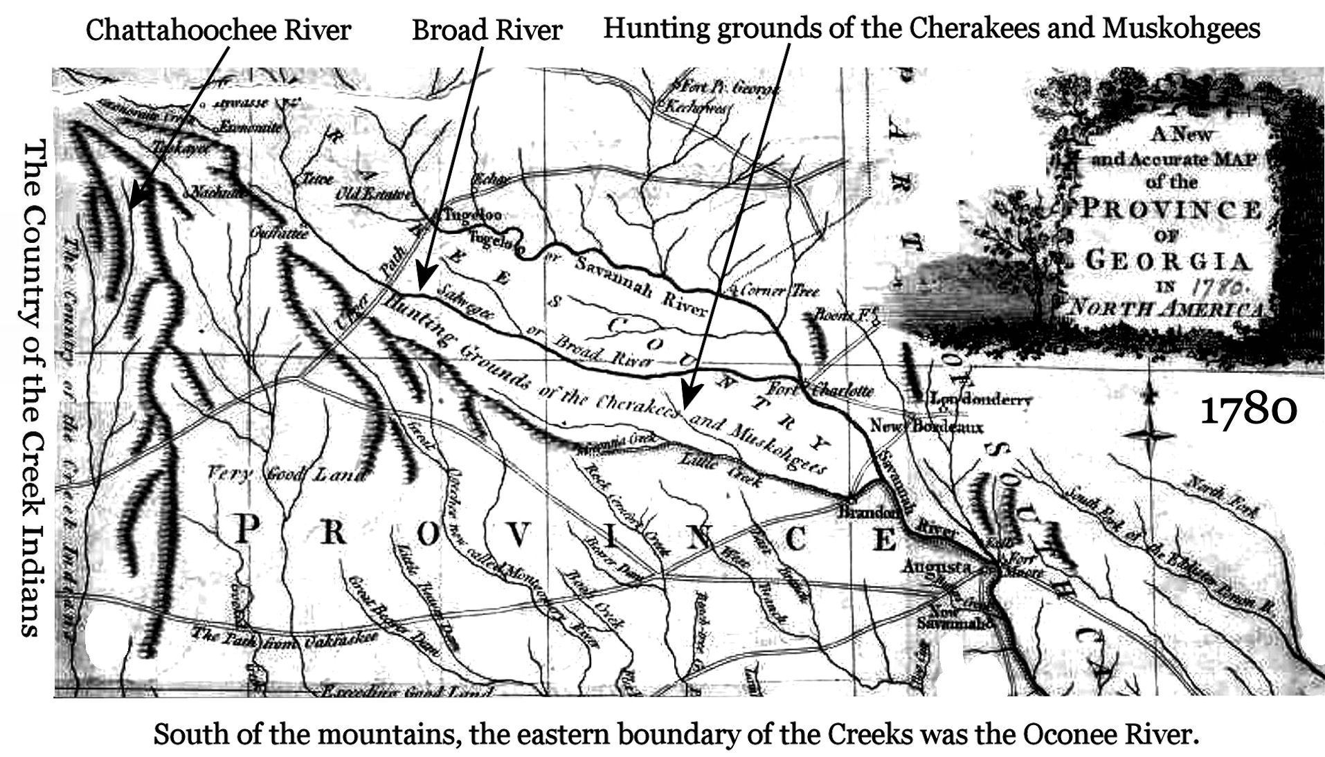
A North Carolina State Historical Marker in Otto, NC states that the southern boundary of the Cherokees in 1760 was Itsate Pass, which was a few miles south of the present North Carolina-Georgia state line. 1 William Bartram stated that in 1776, the sovereign territory of the Creek Nation began south of the Tallulah River, about 15 miles south of the state line. South of the Tallulah River, a hostile band of Cherokees could not pursue him. 2 As can be seen below, the official 1780 map of the Province of Georgia labeled the headwaters of the Chattahoochee River as the eastern boundary of the Upper Creeks within the Georgia Mountains. Both Brasstown Bald Mountain and Track Rock were in their territory.
The descendants of Georgia’s and Alabama’s indigenous peoples are embarked on a long, comprehensive research project to determine the factual history of this region before it was fully occupied by peoples from the Old World. Far too much of the Southeast’s “official early history” was originally the speculations of outsiders and newcomers, or else academicians, who never bothered to learn the languages and oral traditions of Southeast’s true indigenous peoples. We are finding that in the Pre-Columbian past, many peoples came from many places to settle here . . . in the process, blending their cultural traditions with those, who came earlier.
Dr. William F. Stephenson’s account of Track Rock Gap is particularly important because it was the first and last time that an educated Anglo-American visitor gave much thought to the archaeological site, while actually seeing the petroglyphs and ruins. With the exception of pioneer Georgia archaeologist Charles C. Jones, Jr. in 1873, subsequent generations parroted Stephenson’s interpretations of the petroglyphs and stone ruins to the point that everyone considered them factual . . . even attributed them to the knowledge of ancient Cherokee elders.
The vast majority of “experts” quoted by the news media in 2012 never had seen the Track Rock ruins. None had seen Itza Maya terrace complexes in Mesoamerica, nor were any of the speakers knowledgeable of the Maya writing system. Obviously, none of the “experts” presented by the Georgia Council of Professional Archaeologists . . . including its “international expert on rock art” . . . had ever seen Swedish Bronze Age petroglyphs. In fact, the 1891 Smithsonian report on Track Rock was disdainful of Jones’ writings, because it correctly stated that stone ruins dotted the landscape of North Georgia, until it was settled by white pioneers. 3
Brief biography of William F. Stephenson*
*Some of the biographical information on Stephenson in Wikipedia is incorrect.
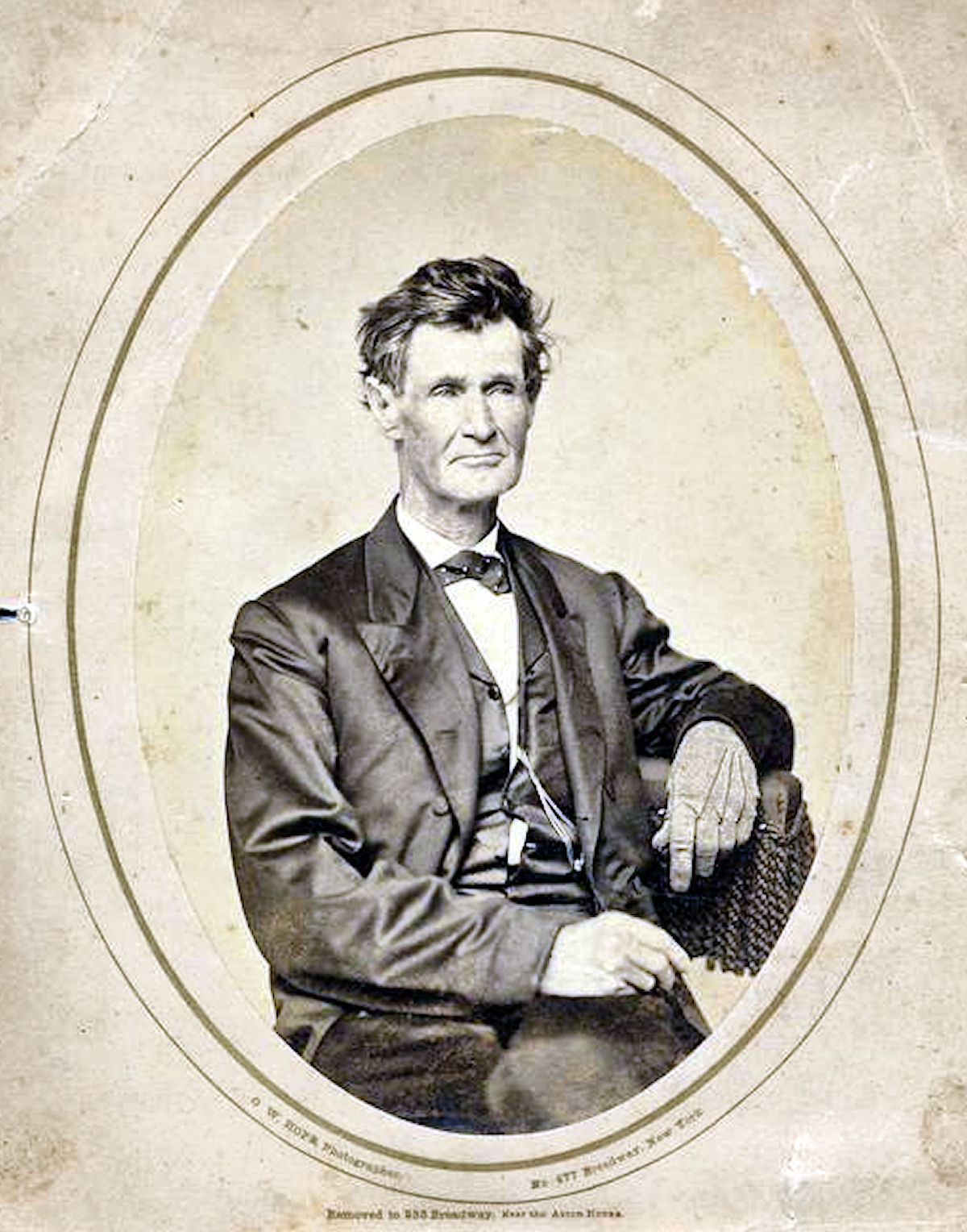
Dr. Matthew Fleming “M. F.” Stephenson was born on January 28, 1802 in Parkersburg, West Virginia. 4 He died in Gainesville, GA on May 24, 1881. On February 25, 1836, he married Sarah Elizabeth Sumter Lyon of Hawkins County, Tennessee, which is immediately west of the city of Kingsport. She was born in 1807. Both are buried in the Alta Vista Cemetery in Gainesville, GA.
At the present time, very little is known about Stephenson, prior to is arrival in Georgia. In fact, it is not really known, when he arrived in Georgia. Most likely, he was living in Northeast Tennessee, when he met Sarah. Given their age, both were probably widowed. It is quite possible that Stephenson taught Natural Science at the famous Jonesboro Academy in Northeast Tennessee. Many biographers diss his “doctor” title, exclaiming that there is no record of him obtaining a degree in geology. At that time here was no college degree in geology. The discipline was known as Natural Science then.
Stephenson’s obituary in the Gainesville newspaper described him as an avid hiker, who didn’t like horses. 5 Up until the age of 76, he would walk to towns up to 20 miles away and then return the same day. His physical strength and personal energy were an asset in his profession. After leaving the employment of the mint, his professional work involved long journeys into remote sections fo the Southern Highlands, plus strenuous climbs up mountains.
He was considered a Georgia’s first professional geologist. Stephenson wrote various articles on his observations of minerals, as well as mound excavations in Georgia. 6 In the 1870s, several of his articles were published by the Smithsonian Institution, including Account of Ancient Mounds in Georgia and Mounds in Bartow County near Cartersville, Georgia. These described sites he visited and the artifacts found at each, such as mica mirrors, copper vessels, and quartz. He also published a major treatise in 1871 called Geology and Mineralogy of Georgia for which he is most famous. Other published works include a pamphlet Diamonds and Precious Stones in Georgia in 1878 and a historical sketch in 1866, Report on the Lewis Mine Property, White County, Georgia.
Stephenson served as the assayer of the Dahlonega Mint in Dahlonega, Georgia in the 1840s. When the gold rush in Georgia was believed to be over, many miners headed west to join the 1849 California Gold Rush. Stephenson thought differently and in the town square proclaimed to over 200 men, “Why go to California? In that ridge lies more gold than man ever dreamt of. There’s millions in it.” This excerpt was retold to Mark Twain by the miners who moved to California from Georgia and may have inspired his character Mulberry Sellers. Sellers was famous for his lines “There’s gold in them thar hills” and “there’s millions in it.”
What is not generally known about Mathew Stephenson is that he was the first person in the United States to officially find a diamond. Elizabethan historian, Sir Richard Hakluyt described journeys by Spanish traders into the Georgia Mountains to obtain gold, diamonds, rubies and sapphires, but this fact was generally forgotten by the 1800s. 7 In 1843, Stephenson traveled about a 100 miles northeastward to pan for gold on Brindletown Creek in Burke County (west-central North Carolina). There he found a clear, octahedral diamond, worth $100 back then, but worth about $3,400 in 2019. 8
That same year he found smaller diamonds in streams near Gainesville, GA. Stephenson was aware that Georgia gold miners had been finding diamonds while panning for gold, but they thought that they were exceptionally clear quartz crystals. A prevailing rumor around Gainesville is that a major source of Stephenson’s wealth was made by purchasing “quartz crystals” from miners and then selling the diamonds to jewelers in Savannah and Charleston.
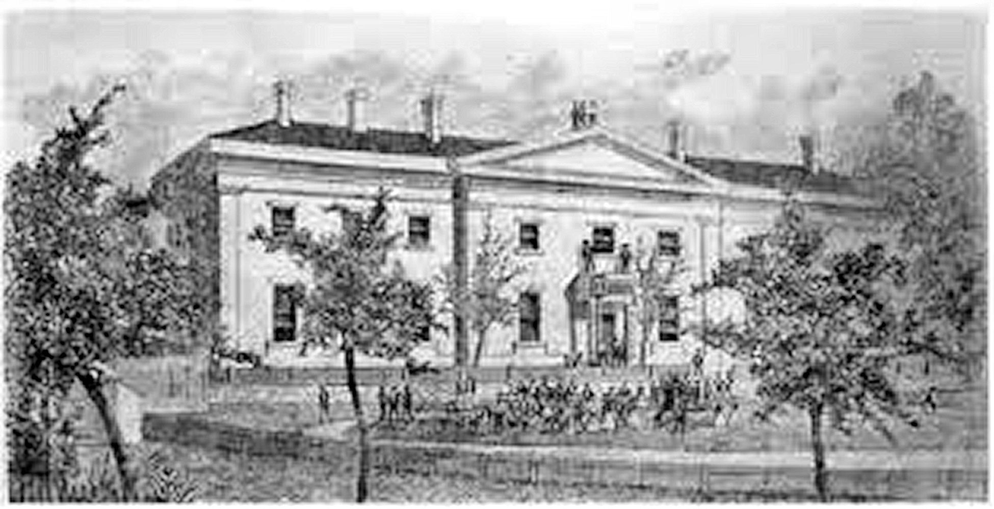
The Dahlonega Mint
The Act of March 3, 1835 was passed by the United States Congress, which provided that “branch mints of the United States shall be established as follows: One branch at the city of New Orleans for the coinage of gold and silver; one branch at the town of Charlotte, NC for the coinage of gold only and one branch at or near Dahlonega, GA also for the coinage of gold only.” The legislation was due primarily to the political influence of southern congressmen from the gold region.
An initial appropriation of $50,000 for the Dahlonega Mint was provided by the Congress. The commissioner of construction was to be Ignatius Few,a lawyer and Methodist minister, best known as the founder of the institution known today as Emory University.
Joseph Singleton, a plantation owner from Athens, Georgia, was appointed as the new branch mint’s first superintendent. He was described by the editor of the Dahlonega Watchman as “altogether too weak in the upper story for any kind of business that requires an effort of mind.”
The mint struggled with a wide range of problems throughout its existence between 1838 and 1861. From the beginning it suffered from Few’s inept management. The Greek Revival building was designed by the famous architect, William Strickland, but the laborers hired to build the structure were not terribly skilled and there was no source in northern Georgia for bricks. The workers tried to make bricks from local volcanic clay, but they were of poor quality.
Once in production, the mint had chronic problems because of its remote location and the extremely pure quality of Georgia gold. This is where Mathew Stephenson played a critical role as an assayer-chemist. The workers at the plant had to dilute Georgia gold with copper to get it down to the standard set by the US Department of the Treasury.

A opposite problem occurred after the beginning of the California Gold Rush. Georgia lost many of its miners to California. There was a stark drop in the availability of Georgia gold. The California gold was significantly inferior to Georgia gold, therefore the Dahlonega Mint had to mix Georgia gold with California gold to meet the Department of Treasury’s standards. The California gold also was much more expensive to purchase, since it was transported by ship around the tip of South America. Ultimately, “quality enhancement” became the primary use of Georgia gold . . . an additive to gold from other parts of the nation to improve its quality.
At the onset of hostilities between the United States government and the Confederacy in April 1961, the Dahlonega Mint closed permanently. A pro-Union militia had been raised in the Cartersville-Dawsonville Area to protect the mist from Confederate troops, but this ultimately was viewed as a suicidal and fruitless objective. At the end of Reconstruction in 1871, the Dahlonega Mint was given to the State of Georgia. It became the first building of what is now the University of North Georgia.

Enchanted Mountain
by William F. Stephenson
The elevation of this mountain is considerable compared to the Blue Ridge of which it forms a part, the latter being at this point probably 4,000 feet above Atlantic level. The main chain of mountains is about fifteen miles broad, and forms the great natural barrier between the eastern and western waters,
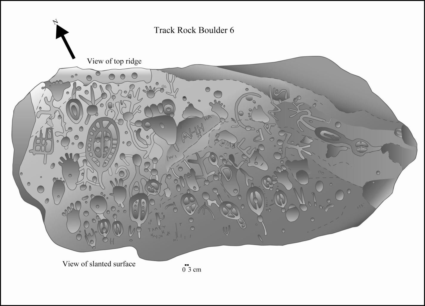
The Enchanted Mountain is a spur of this chain, about 10 miles north of it, and derives its name from a great number of tracks or impressions of the feet and hands of various animals in the rocks, which appear above its surface. The number visible or defined is one hundred and thirty-six, some of them quite natural and perfect, others rather rude imitations, and most of them, from the effects of time, have become more or less obliterated. * Stevenson apparently saw only one of the six petroglyph boulders.
They comprise human feet from those of four inches in length to that of the great warrior, which measure seventeen and a half inches in length, and seven and three- quarters in breadth across the toes. What is a little curious, all the human feet are natural, except this which has six toes, proving him to have been a descendant of Titan. There are twenty-six of these impressions, all bare, save one, which the appearance of having worn moccasins.
A fine-turned hand, rather delicate, occupied a place near the great warrior, and is probably the impression of his wife’s hand., who no doubt, accompanied her husband in all his excursions, sharing his toils and soothing his cares.
Many horse tracks are to be seen. One seems to have been shod. Some are very small, and one measures twelve and a half inches by nine and a half inches. This the Indians say, was the great war-horse, which their chieftain rode. The tracks of a great many turkeys, turtles, terrapins, a large bear’s paw, a snake, and two deer are to be seen.
The Indian tradition respecting these impressions varies. One tradition asserts that the world was once deluged by water, and man and all animated beings, were destroyed except one family, together with the various animals necessary to replenish the earth – – -that the great canoe once rested on this spot – – – and here the whole troop of animals was disembarked, the leaving the impressions as they passed over the rock, which being softened by reason of long submersion, kindly received and entertained them.
Others believe that a very sanguinary conflict took place here, at a remote period between the Creeks and the Cherokees, and that these images of hieroglyphics were made to commemorate that even, They say that it always rains when any one visits the spot, as “sympathetic nature wept of the recollection of the sad catastrophe, which they intended to commemorate.”
A late tradition asserts it to be the sanctuary of the Great Spirit, who is so provoked at the presumption of man in attempting to approach so near the throne of Divine Majesty, that he commands the elements to proclaim his power and indignation by awful thunderings and lightning, accompanied by deluges of rain that his subjects might be kept in awe and fear, and constrained to venerate and adore their God.
At six A.M. we arrived at the summit of the mountain. As we approached it, the heavens, which before for several days and nights had worn a brightest countenance, began to scowl and threaten; we advanced with a quickened pace to the foot of the rock and spread out our breakfast on the “table of stone, poured out a libation to the appease the wrath of Jupiter, drank a few appropriate sentiments, and then, with a chisel and hammer, commenced the resurrection of one of the tracks. Notwithstanding I believe I possess a little superstition as any one, yet I could not suppress a strange sensation that pervaded me. A thousand circumstances were identified with the present: a sanguinary and long-contended battle had evidently been fought here, from the large and extensive heaps of loose rocks, which were piled over the slain—the sacred veneration of the Indians have for their dead—their present and former relations with the whites . . . . . . . The tradition being so completely fulfilled, rather astonished me; for so sooner did we arrive on consecrated ground, then it began to threaten, and the first stroke of the hammer in the sacrilegious act of raising the track of a human being, was responded to by a loud peal of thunder; the clouds continued to thicken and condense, attended by awful thundering and the most vivid lightning, when a deluge of rain was precipitated upon our offending heads. I continued, however, to labour incessantly , until I succeeded in disintegrating the impression of a youth’s foot, which I carefully wrapped up, and sounded a retreat, still, however, looking back towards the sepulchers of the slain, in momentary expectation of seeing a legion of exasperated ghosts issuing forth to take vengeance on the infidel who would presume to disturb the sacred relics of the dead. As soon as we passed confines of the mountain, the rain ceases, the sun broke out, and all nature resumed her cheerful aspect.
At nightfall we camped upon the summit of the Blue Ridge, and after partaking of some “corn dodgers” and cheese, we retired to rest. The rock upon which these impressions are made is an imperfect species of soapstone, which, more than any circumstance, we believed to be a production of art.
After excessive fatigue, an no inconsiderable danger, we arrived at the summit of the Blue Ridge, where was presented to our enraptured view one of the most magnificent scenes anywhere to be met within the United States. On the north and west, range after range of lofty mountains rise by regular gradation, one above another, until lost in the distance. On the east is Tray Mountain, peering above the clouds, and giving rise to several mighty rivers. Southward appears Old Yonah in the distance, rising proudly pre-eminent above the surrounding battlements, maintaining a isolated dignity, and calling forth the most unqualified strains of approbation.
In the evening we descended in a northwestern direction, and encamped within four miles of the Enchanted Mountain. The country here presents a most charming prospect. The gently undulating hills cover a carpet of the richest verdure—the green foliage of the trees, and he countless variety of the most splendid flowers, scattered in gay profusion over the whole face of the country, gave the appearance of enchantment.

Notes
- This is the old silver and black marker in Otto, NC. There are newer state historic markers nearby and in Downtown Franklin, which don’t mention the boundary between the two British colonies.
- Bartram, William [1791] Travels Through North & South Carolina, Georgia, East & West Florida, the Cherokee Country, the Extensive Territories of the Muscogulges, or Creek Confederacy, and the Country of the Chactaws; Containing An Account of the Soil and Natural Productions of Those Regions, Together with Observations on the Manners of the Indians; p. 348.
- Mooney, James [1900-1995] Myths of the Cherokee; New York City: Dover Publications, pp.418-419.
- Find A Grave – https://www.findagrave.com/memorial/68538441/matthew-f-stephenson
- Vardeman, Johnny, Gainesville Citizen-Times, [Jan. 3, 2010] “Mining assayer Stephenson favored feet over horses in 1800s”.
- Matthew F. Stephenson (1871). Geology and Mineralogy of Georgia: With a Particular Description of Her Rich Diamond District; the Process of Washing for Diamonds, Their Price and Mode of Cutting and Setting; Her Gold, Silver, Copper, Lead, Iron, Manganese, Graphite, Kaolin, Coal, Fire-clay, Mica, Corundum, Slate, Marble, &c. Globe Pub. Company.
- Krajick, Kevin [2016], Barren Lands: An Epic Search for Diamonds in North America, New York City – Open Road Integrated Media, (no page numbers).

In the bottom picture you can see my house – the tiny white dot on the mountain ridge to the left of Soque mountain in front of Currahee (you have to zoom in to see it) I. I have been told that this is Yellowbank Mountain, but I am thinking that there is another name. Do you know it? Also the setting sun lines up with the top of Yonah Mountain on the spring equinox as a side note.
LikeLike
Sorry, Laura, I don’t know the name of that mountain.
LikeLike