Habersham County, Georgia
34°39’33.0″N 83°37’59.2″W
by Richard L. Thornton, Architect & City Planner
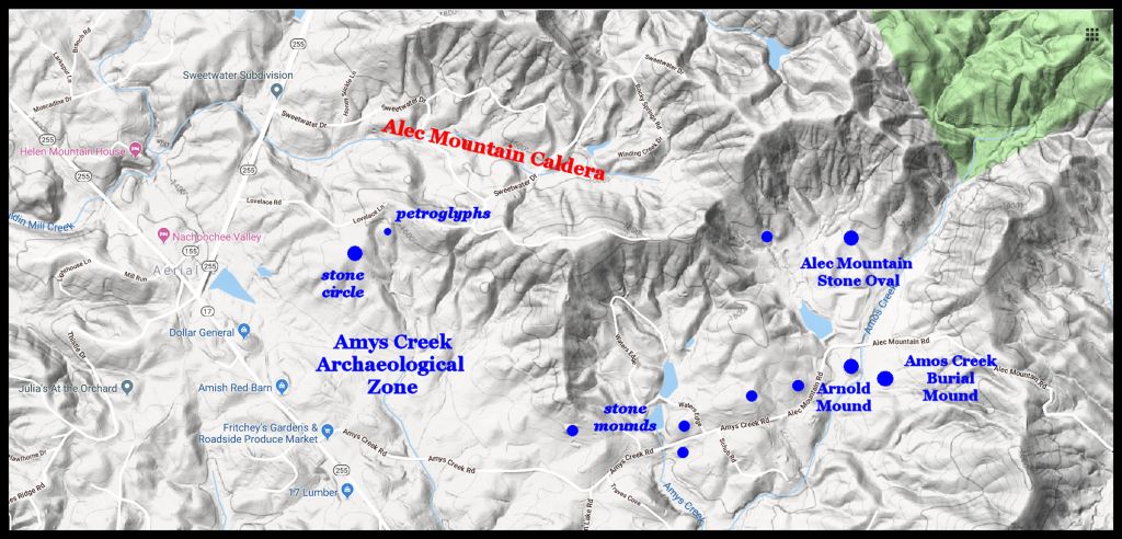
A newly discovered archaeological zone in Northeast Georgia contains stone mounds, earthen mounds, stone circles , stone effigies, petroglyphs and village sites. It’s got everything and it is quite old! The zone is immediately west of the Alec Mountain Archaeological Zone, which contains the Alec Mountain Stone Oval. The Stone Oval is the only archaeological site in this area, which has an official state site number.
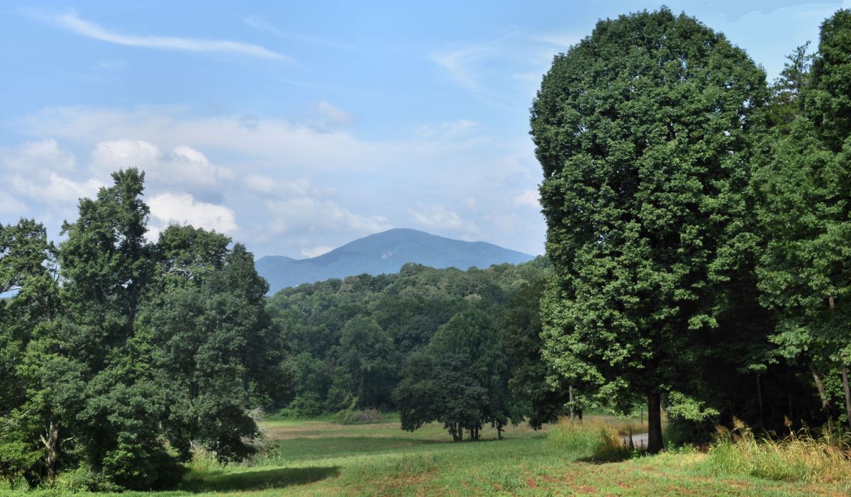
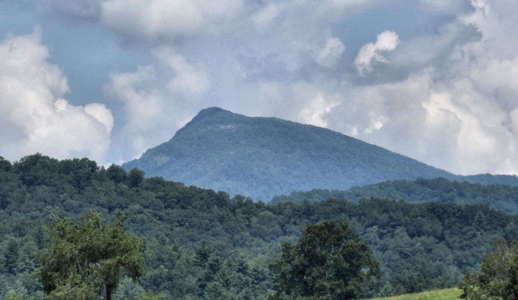
Photo Above: Even though Yonah Mountain dominates the horizon at many locations in this archaeological zone . . . and the view is quite spectacular from mountaintops . . . I could find no ancient architecture, which was oriented to Yonah. Most seemed to be oriented to Enotah Mountain, a much lower peak, southeast of Cleveland, GA or to Brasstown Bald Mountains, 18 miles to the north-northwest. The site is 22 miles southwest of the Track Rock Terrace Complex.
During March 2019 I discovered a new archaeological zone on the eastern end of the Nacoochee Valley in Habersham County, GA (Northeast Georgia Mountains) while hiking with my dogs. The previous month we discovered a previously unknown archaeological zone on Upper Mauldin Mill Creek within an ancient caldera, complete with a large stadium, on the north side of this zone and Alec Mountain.
Although northwestern Habersham County was briefly visited by Cyrus Thomas of the Smithsonian Institute in 1886, Robert Wauchope of the WPA in 1939 and Phillip White of Harvard University in 1951, these famous archaeologists literally missed hundreds of ancient ruins. None of the ancient features I found have been assigned official state archaeological site numbers. Evidently, it was the will of the Master of Life that the only house I could afford in early 2018 was in the midst of this treasure land from the past.
To reach both the Amy’s Creek and Alec Mountain Archaeological Zones, either take GA 17 northwest from Clarkesville, GA or GA 17 eastward from the Nacoochee Mound to GA 17’s intersection with Amy’s Creek Road. An excellent view of both archaeological zones can be had from Fritchey’s Farm Market at the intersection of Amy’s Creek Road and GA 17. There are also rises along Amy’s Creek Road with good views.
Highway 17 is the famous Unicoi Turnpike, which connected the Savannah River with the Tennessee River. Except in Northwest Habersham County, the Turnpike followed the route of the Unicoi Trail, which according to Creek Indian tradition, was built by direction of a famous Apalache-Creek queen. The word is Creek and means “trail between waters (rivers).” Evidence suggests that the Apalache-Creeks merely improved an much older trail, which connected the headwaters for freight canoe transportation on the Savannah River with the gold deposits, diamonds, rubies and sapphires of the Nacoochee Valley.
The stone and earthen structures are clustered around the headwaters of Amy’s Creek, which flows into the Chattahoochee River, a few miles to the south. Pre-Columbian structures in this zone include village sites, petroglyphs, stone mounds, at least one large stone enclosure, stone circles, earthen mounds and a level, mountaintop worship area, oriented to the Winter Solstice Sunset. This archaeological zone is immediately west of the Alec Mountain Archaeological Zone, which includes the Alec Mountain Stone Oval and the newly discovered Arnold Mound and Amos Creek Burial Mounds.
A low ridge separates the cluster of Native American structures along Amos Creek from a wider expanse of tillable land and a village site, drained by Amy’s Creek. The grade is not absolutely flat, but the sandy volcanic soil is quite fertile. It is being cultivated nowadays by Mr. Fritchey, who markets his produce at the farm store on Hwy. 17.

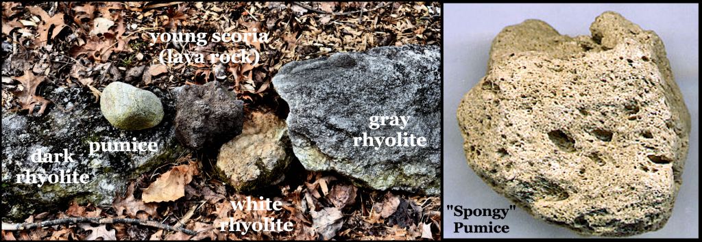
Geological History: Both the Amy’s Creek and Alec Mountain archaeological zones are located on the southern flank of an ancient caldera volcano. In fact, the entire northwest corner of Habersham County is a larger caldera, within which are lava fields, smaller calderas and eroded volcanic cones. All of the stones and rock strata . . . typically rhyolite . . . are volcanic, but much younger than the granitic rocks of the Georgia Piedmont, immediately to the south. The “sand” between the red subsoil and black topsoil is actually volcanic ash. On my property, I have also found lava bombs from fairly recent eruptions. They are black scoria, brown scoria or pumice. These lava bombs, along with the layer of volcanic ash, are very young rocks and are proof that at least one of the mountains to the north of the archaeological zone is dormant rather than extinct.
A petroglyph in the Amys Creek Archaeological Zone


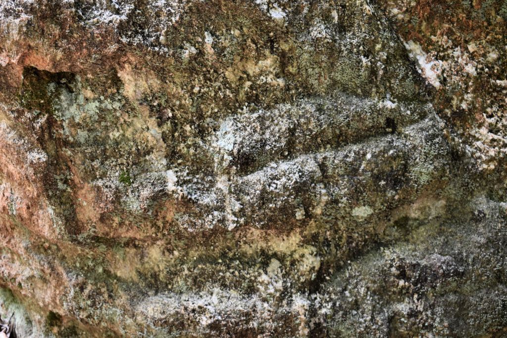
In early April, I found a large, enigmatic petroglyph boulder that is quite different than most petroglyphs in the Georgia Gold Belt. In fact, no Mexican archaeologist would bat an eye, if I showed him or her photos of the boulder and said it was from an Olmec Civilization site. The left side of the boulder carved face consist of horizontal lines crossing through a chevron pattern. The right side is a seated man with a headdress. Someone in the past chipped away the upper torso and head of the seated figure, but his hand, arm and bracelet are clearly visible, even today. The boulder is a coarse rhyolite with very sharp quartz crystals protruding from the surface. It is typical of that particular mountain.

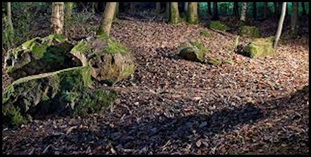
Stone Ruins in the Amys Creek Archaeological Zone
Scattered about the archaeological zone on natural knolls and terraces are stone cairns, stone mounds and stone circles. These are of unknown age and don’t seem to contain any artifacts, which can be reliably dated. The Alec Mountain Stone Oval, the other un-named stone circles, stone cairns, plus the Rob Roy Petroglyphic Boulder are all located at elevations ranging from 1700-2000 feet (518-620 m) above sea level. The stone cairns and stone mounds are located on knolls or terraces that are visible from Amy’s Creek and typically are about 1200 feet (366 m) above sea level.
Chronology: Local residents have found a wide range of pottery styles, while cultivating the land along Amy’s Creek. The location was always occupied during the period, between around 1000 BC and 1700 AD, but population densities fluctuated. The preponderance of styles during the Archaic, Middle Woodland and Late Mississippian Periods (Deptford, Cartersville Check Stamp and Swift Creek) suggest that it was between 1000 BC and 600 AD, plus between 1350 AD and 1700 AD that this region was most densely populated. It is quite likely that there are much older artifacts, however, not visible on the surface . . . as the Nacoochee Valley Area was densely populated by large mammals during the end of the last Ice Age. In 1939, archeologist Robert Wauchope found 35 Clovis Points while removing alluvial soil to get to much younger human occupation zones.
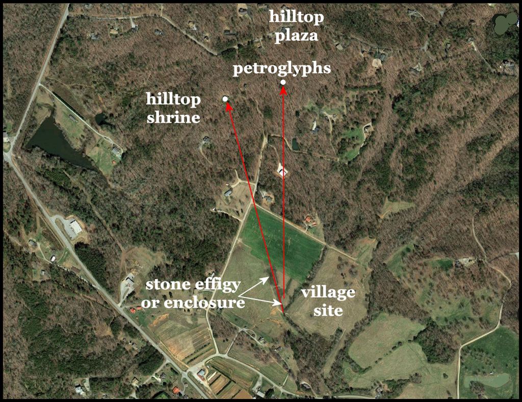
Early and Middle Mississippian village sites are concentrated around Sautee, about three miles to the northwest. The Creek name for Sautee was Itsate, which means Itza People. The original village of Sautee was 3.5 miles due north of the Amy’s Creek village sites. The newest Native American pottery is polished blackware, which was typical of the Soque in Georgia and Zoque in Mexico. This style of potsherds is densest in a triangle, immediately east of the stone structure.
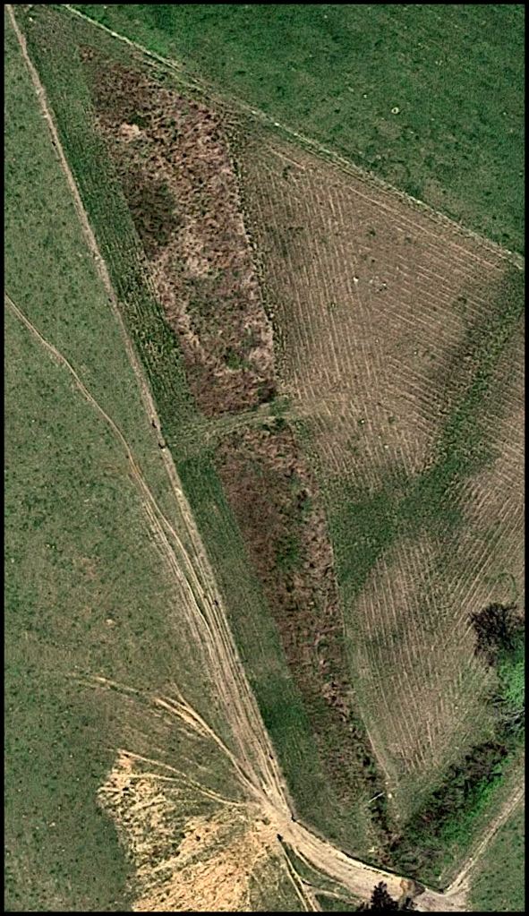
An unusual earthwork, veneered with field stones is clearly visible immediately west of the area where potsherds are densest. It is an effigy of “something” . . . most likely the ceremonial mace carried by the ruling elite in Proto-Creek towns. No investigative work has been carried out by a professional archaeologist at this village site. Therefore, more detailed information about its chronology and site plan is unavailable.
About 200 feet southeast of the stone veneered earthwork is a stone veneered mound about 25 feet in diameter. North of it is a smaller earthen mound . . . probably a burial mound. Also visible on satellite imagery are several dark circles, which may be either plowed over mounds or former structures. Without on-site archaeological investigation, this cannot be determined from visual examination.

I’m totally intrigued. My people hail from here. I have returned to the area. I will continue to study what you have put forth.
LikeLike
The Arnold Mound is almost identical to Mound A at Kolomoki in deep SW Georgia. I have a suspicion that when the town of Kolomoki was abandoned, its inhabitants followed the Chattahoochee River upstream to Amy’s Creek.
LikeLike