
by Richard L. Thornton, Architect & City Planner
The Battle of Taliwa never happened, but most of the other aspects of Nancy Ward’s mythological life just do not add up. For example, her white father’s family were from County Antirm, Ireland and settled first in Southeast Georgia. That family, including her first cousin/husband, always lived in the section of Georgia, which maps show to be occupied by Creeks, Apalache and Chickasaw until after the Revolution! Her first cousin-husband, Bryant Ward, never lived in Tennessee!
–
Part One of this series, a team of University of Oklahoma professors, who thoroughly examined the early archives of Georgia, South Carolina and Tennessee, discovered that there was no Battle of Taliwa, no Creek town named Taliwa anywhere and the Cherokees catastrophically lost the 40 year long Creek-Cherokee War. How did this myth begin?
I started with the Wikipedia article on Nancy Ward then followed the paper trail of references back in time. The trail ends with a dime novel, published in 1828 by a distant white cousin of Nancy Ward. He lived in the same community, Greenville, TN, in which another amateur historian had become wealthy, with dime novels about Davy Crockett! What I also found was that in the late 20th century, various anonymous individuals, all with European/English names, continued to exaggerate and extrapolate the life of Nancy Ward, based on fictional “base” information created by a John Ward, four years or more after Nancy’s death.
I have found that many, if not most of the Ancestry.com biographies, created by amateurs, to be very, very dubious. Like most Wiki type documents, no one is minding the hen house, who has a lick of knowledge about Southeastern history. Nancy Ward’s supposed white father always lived in either Ireland or the South Carolina Low Country. He died in 1722, so he couldn’t be her father, even if you believe that she was 16 years old in 1754. Bryant Ward supposedly married Nancy two years, after her Cherokee husband was killed in 1754. That would have him traveling through the heart of Cherokee Country, during the midst of the bloody Anglo-Cherokee War . . . when hundreds of people on the frontier were being killed by Cherokee war parties. The anonymous sources in Ancestry.com had Bryant Ward’s first, Irish born wife, dying in Stephens County, GA in 1744. Another listing showed Bryant Ward and his family living in Franklin County, GA all his life.
Neither Franklin or Stephens County were occupied by whites or even existed until after 1784. Actually, Stephens County, GA was created in 1905. Nevertheless, it is very clear that Nancy Ward’s husband always lived in a section of Georgia, which was within the boundaries of the Creek Confederacy until occupied by whites. Bryant lived a long, long way from Chota, where Nancy Ward lived . . . if indeed that is where she was born.
Take a look at the genealogy websites for Nancy Ward. They provide several different dates for both her birth and date, but the most credible are newspaper obituaries at the time of her death, which say that she died in 1824 at the age of 70. That means she was born about the same time that she was leading the charge at the fictional battle of Taliwa. There are also biographical articles by amateurs, such as in Wikipedia, which accept the fictional account of her life then interpolate the dates to match them.
Kingfisher may have been Nancy Ward’s first husband. He was a highly respected Cherokee warrior, but he died on November 17, 1793 at the Battle of Etowah Cliffs on the Etowah River in present day Rome, GA. He did not die in 1754 or 1755 at the Battle of Taliwa, nor did this battle even occur.
Someone decided that the name of Nancy’s brother [if even that is true] Tuskegeetehi, means “Creek killer.” It does not. The word means that he was born in the Cherokee village of Tuskegee on the Little Tennessee River.
The current absurd situation in Southeastern Native American history
The Eastern Band of Cherokee Indians erected a sign on a Proto-Creek mound in Hayesville, NC, which states that after 1756, the Hiwassee River Valley was almost completely abandoned by the Cherokees, “because of repeated attacks by Upper Creek towns located nearby in the Georgia Mountains.” However, go to the Museum of the Cherokee Indian or any book store in Hayesville, Murphy, Cherokee or Asheville, North Carolina and you will find exhibits and a legion of books that describe how “the Cherokees conquered all of North Georgia in 1754.”
The situation is just as absurd in Tennessee. A chapter in the state’s official history text tells you that by 1754, Upper Creeks had reconquered all of their land up to only a few hours walk from the main eight towns of the Overhill Cherokees. Chicksaw war parties were attacking from northwest Georgia and northeast Alabama, while Shawnee war parties were attacking from Kentucky. The book states that the Cherokees sent delegations to Charleston and Williamsburg, begging for help from British officials, because they feared that all of their towns could be overrun at any time. In response, South Carolina and Virginia built Fort Loudon and garrisoned it with Redcoats.
That same chapter includes a map, which labels all of Kentucky, the eastern half of Tennessee, the northern halves of Alabama and Georgia, plus the northern half of South Carolina as “the traditional lands of the Cherokee Indians.” In fact, the map labels ALL of the traditional territory of the Chickasaw as always having been Cherokee. So the Cherokee’s mortal enemies lived on traditional territory? That didn’t happen.
The next chapter in the Tennessee state history text tells the beautiful story of Tennessee Cherokee heroine, Nancy Ward (Nanihi). It tells us that the Overhill Cherokees in 1755 sent 800 warriors through 112 miles of Upper Creek territory . . . the same Upper Creeks, who were about to overrun their towns . . . to capture the Muskogee Creek capital on the Etowah River . . . thus conquering all of northern Georgia. The Muskogee-Creeks never lived in North Georgia, but Cherokees and historians in Tennessee and North Carolina probably didn’t know that. Surely, some history professor or high school history teacher in Tennessee has realized the incongruities of the two chapters, but apparently they haven’t.
What really happened was that the late spring of 1754 the British persuaded the Upper Creeks to cease their attacks on the Overhill towns. They and the Cherokees signed a peace treaty, which gave all the land south of the Hiwassee River in Tennessee, North Carolina and Georgia back to the Upper Creeks. During that summer, all of the other Creek provinces, except Koweta, signed the peace treaty also. Construction of Fort Loudon was begun in 1756.
Koweta had a legitimate reason to refuse peace with the Cherokees, but no one dreamed that a single Creek province would dare attack the entire Cherokee tribe. In December 1715, the Cherokees had invited Creek leaders from Georgia, North Carolina and South Carolina to a diplomatic conference at the neutral Uchee village of Tugaloo.
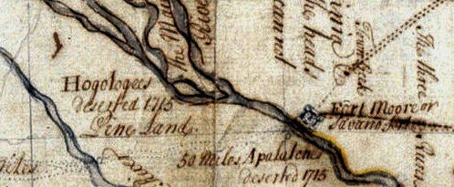
Despite what all the historic markers, books and Chamber of Commerce texts tell you, Tugaloo was a Uchee village. Tugaloo is the Anglicization of the Cherokee-nization of the Tokah-le branch of the Uchee. The British called them Hogeloge. As shown on the colonial era map above, Tugaloo was described as a Uchee village in 1737 by the Rev. Charles Wesley, Indian Agent for the Province of Georgia.
Chara-te Hagi, a South Carolina sorcerer with a Middle Eastern title, hagi, persuaded the Cherokees to kill all 32 Creek delegates in their sleep. While the Creeks were in a state of shock, the Cherokees seized Creek lands in Tennessee, North Carolina and Northeast tip of Georgia. Significant territorial expansion ceased in mid-1717, when the Creek Confederacy was formed. The Creek-Cherokee War was to continue, however, until 1754. On several occasions, the Cherokees would have been wiped out by combined invasions of the Creeks, Shawnee, Uchees and Chickasaws, but the Cherokees were each time warned in advance by the British so that they could bring their warriors together and send the women and children up into the mountains.
At the end of the fall harvest in 1754, Koweta launched a blitzkrieg up the Chattahoochee River and then down the Little Tennessee River. The Early History of Jackson County, Georgia [1911] states that the Bohurons played a major role in the almost instantaneous collapse of Cherokee military prowess. The Bohurons were mixed-blood Creeks with Dutch, Spanish, Portuguese, Hebrew and French names, who road their Arabic horses into battle like the Comanche. Bohuron is an Arabic, Moorish and Ladino Spanish word, meaning “nobility.”
We last hear of the Bohurons in Georgia, when they were based in the vicinity of present day Six Flags Over Georgia in the 1820s. Their repeated livestock raids on the Cherokee farms made the southern third of the Cherokee Nation unlivable. Georgia authorities did nothing to stop the raids because they wanted the Cherokees gone. The removal of the Cherokees coincided with the Texas War of Independence. It is believed that the Bohurons joined hundreds of affluent mixed-blood Creeks from West Georgia and became some of the founders of the Texas Republic. I have feeling that these brigands were then unleashed on the Comanches and Mexican cavalry then became respectable cattle barons.
The Cherokees were totally unprepared for lightning attacks by cavalrymen followed by Koweta shock troops. Unlike Creek towns, the Cherokee villages were not fortified. Soon the mere appearance of Creeks near a village, would cause all of the inhabitants to flee in terror without putting up a fight. Much of the tall tales and bravado one sees today, which is associated with “Great Cherokee warriors” thing is probably a subliminal compensation to what actually happened during that era. The Cherokees had barely recovered from devastation by Koweta when the British Redcoats turned the North Carolina Mountains into a wasteland. American Patriot forces did it again in 1776 and 1777.
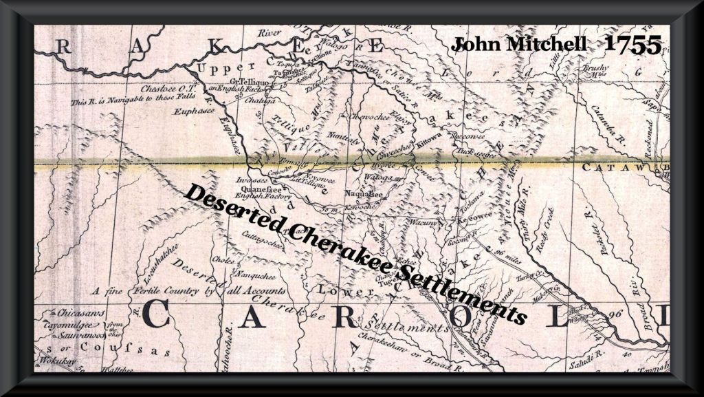
In Part One, we told you that in the autumn of 1754, soldiers from Koweta had devastated all of the Cherokee villages and towns, south of the Snowbird Mountains. The fourth linguistic division of the Cherokees, the Valley Towns, ceased to exist after 1754. Absolute proof of the Oklahoma professors’ findings can be seen on the 1755 John Mitchell Map of North America. The words, “Desserted Cherakee Settlements” is hand-written across a broad swath of Western North Carolina and the northeastern tip of Georgia.
So how could hundreds of thousands of historians and anthropologists get it so wrong for 250 years? One answer is that no one double-checked their sources and academicians in the Lower Southeast stubbornly refused to learn any of the Creek languages, even when they were excavating Creek towns. Another answer is that it was a very long comedy of tall tales and sloppy research.

Terra Incognita
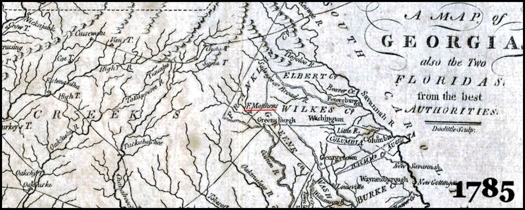
Even as late as the American Revolution, British authorities knew very little about North Georgia or the mountains of North Carolina, north of the Little Tennessee River. The region west of the Chattahoochee River Headwaters [Helen, GA] were occupied by Upper Creeks, who were not terribly fond of the British. Maps as late as 1780 did not even show the 218 mile long French Broad River that flows through Asheville, before joining the Tennessee River in Tennessee. Maps of North Carolina typically stopped at the edge of the mountains. South Carolina claimed North Georgia until around 1790, but its maps either stopped at the mountains or included a narrow corridor along the Little Tennessee, Hiwassee and Tennessee Rivers in NORTH CAROLINA. Most maps of Georgia only included the eastern 25% of the state’s current boundaries. South Carolina maps, showing present day North Georgia, which this colony also claimed, labeled North Georgia “Upper Creeks” or “Appalachian Mountains” but provided no geographical details.
The French first explored Eastern Tennessee, Northwest Georgia and Western North Carolina in the 1690s. They soon built a fort on Bussell Island, where the Tennessee and Little Tennessee Rivers join. It was still there in 1715 and shown on both French and British maps along with Cusate (Upper Creek) villages.. Somehow, Tennessee academicians have forgotten its existence. Until 1717, French maps labeled Western North Carolina as “Nation of the Shawnee,” but also showed Creek villages along the Tennessee and Hiawasee Rivers.
French maps always showed Northwest Georgia to be occupied by Cusate (Upper Creeks) and Apalachicola (Lower Creeks). The mountainous lands of North Central and Northeast Georgia were labeled Cohuita (Coweta Creek) Mountains. After 1763, when the region was clearly in British hands, British mapmakers changed the name to Cohuta Mountains. By the 1800s, Cohuta was assumed to be a Cherokee word of unknown meaning.
Forgotten signs
As one enters Macon County, NC from the south on US 441, there are a series of Georgia and North Carolina state historic markers that describe the early history of the locale known variously as Rabun Gap, Itsate Pass, Echete pass, Etcheo Pass or Etchoe Pass. Itsate and the “Eche” root indicate the presence of Itza Mayas. The “o” suffix is Southern Arawak for “principal or important.” Etchoe is a misspelling of the original village name.
Nevertheless, all signs agree on one thing. Rabun Gap marked the southern boundary of the Cherokee Nation and was the scene of two large battles between the British and Cherokees in 1760 and 1761. In both cases, the Cherokees attacked the British as they entered Cherokee territory about a mile north of the current North Carolina-Georgia line. Hm-m-m . . . I thought that the Cherokees conquered all of North Georgia around 1700 at the Battle of Blood Mountain . . . or in 1754 in a ball game on the Etowah River or in 1755 in the Battle of Taliwa?
Actually the time was the autumn of 1754, but indeed there were fortified Upper Creek towns at the confluence of the Nottely River and Coosa Creek near Blairsville, GA, plus the confluence of Hightower (Etowah) Creek and the Hiwassee River near Hiwassee, GA until the late 1780s. Their occupants never left the region. You can discern Upper Creek descendants, because they are tall and lanky. They have deep set eyes and raptor like facial features. Their women are extremely tall . . . up to six feet.
Chronology of a Forgotten History
The remainder of the article will be a straightforward timeline with little prose. All of the quotes are from published sources. Most, if not all, are available nowadays on the internet. The fact is that contemporary academicians had ignored their contents and implications.
1776 – William Bartram: Upon leaving a cluster of Cherokee villages in present day Macon County, NC Bartram stated that he traveled southward about 20 miles from present day Franklin, NC to the Tallulah River in Georgia, where he reached the safety of the Creek Nation. So even in 1776, the Cherokees only claimed a tiny sliver of Georgia. All of Habersham, White and Lumpkin Counties, GA were in Creek territory.
The Cherokee outdoor drama, “Unto These Hills” describes a grand tour of the Cherokee Nation by Bartram, in which he met all its great chiefs. There is a Bartrum room in the Museum of the Cherokee Indian. In fact, Bartram only briefly visited the southern edge of Cherokee territory and left abruptly, when warned that less friendly Cherokee villages were about to kill him then attack frontier settlements on behalf of the British Army. These few days have been exaggerated into major museum exhibits, theater plays, theses and even dissertations.
Typical of everything else published in recent years, his explorations are labeled, “William Bartram explores the lands of the Great Cherokee Nation and also the Creeks.” Actually, all but about two weeks of his two years of exploration were spent in Creek, Seminole or Choctaw territory . . . mostly Creek.
Battle of Long Swamp Creek
1776 – Indian trader farmsteads: After the Cherokees attacked the frontier settlements in South Carolina, James Adair moved his Chickasaw wife and their children, from Augusta, GA to Oothlooga Creek in Northwest Georgia, near present day Adairsville. It was land allocated to them by the nearby Chickasaw village of Ustanauli, where she grew up. She was actually, at least half Jewish. Her father was descended from Jewish miners, who had settled in NW Georgia in the 1600s.
Several other Indian traders with names such as Thompson, Quinlan, Harnage, Saunders and Kelly with Native American wives, soon left Augusta and followed Adair to settle on Salicoa, Pine Log, Scarecorn, Talona, Petit and Talking Rock Creeks. Their children and grandchildren became some of the most prominent leaders of the Cherokee Nation in Georgia, even though most had no Cherokee heritage.
1778 – Banishment of Sour Mush: By 1778, the Cherokees had been defeated catastrophically by American Patriot forces. Because of Cherokee atrocities in South Carolina, the Patriot militiamen showed little mercy to Cherokees, regardless of age or gender. Most of the Cherokees, who befriended Bartram took no part in the raids, but were, nevertheless, probably dead. Their villages were burned and permanently abandoned.
Sour Mush, was one of several minor Overhill Cherokee chiefs, who refused to cease hostilities. They were banished from Cherokee lands. Most renegade bands traveled to the territory of the Chickasaw in what is now the western edge of Northwest Georgia and Northeast Alabama. The Upper Creeks were allies of the British AND the renegade Cherokees. They allowed renegade Cherokee bands to settle in their lands.
By 1780, Sour Mush’s band of about 50 followers had established a hamlet in an uninhabited section of North-Central Georgia, claimed by the Upper Creeks, who allowed the Elate (Foothill People) to live there. The hamlet was on Long Swamp Creek near the small present day community of Nelson . . . about four miles from the Etowah River.
1780 Map of Georgia: Royal engineers, commanded by General Cornwallis published a detailed map of the eastern part of Georgia for use by the Red Coats and Tory units in pacifying the province. The map labeled all lands west of the Chattahoochee River where Helen is today and south of Nocossee (Yonah) Mountain in the Nacoochee Valley as being in the territory of the Creek Indians.
1781 – Waters Rangers: Col. Thomas Waters commanded Loyalist garrisons at Ninety-Six, SC and Augusta, GA, until he was driven out of Augusta in June of 1781. He was married to a (at most*) 1/2 Cherokee woman named Sarah Hughes, who was a relative of Sour Mush. He and Sarah had a son, named George Morgan Waters in 1777. Sarah was a 1/2 sister of Cherokees, John Vann and Waw-li Vann (mother of Chief James Vann).
Waters and his men were allowed to establish a camp on the plateau above Sour Mush’s hamlet. From there, they raided and murdered civilians on the Georgia frontier. Many of the rangers had common law Native American wives, but probably most were Creek or Uchee, since they had spent most of the war in Creek territory.
1783 – Battle of Long Swamp Creek: On October 22, 1783, the last battle of the American Revolution occurred at Sour Mush’s hamlet and then moved to the camp of Waters Rangers. Colonel Andrew Pickens and Major Elijah Clark led about 400 Georgia & South Carolina Mounted Rifle militiamen attacked Sour Mush’s village in search of Waters Rangers. A few rangers were in the village. Several were killed or wounded while attempting to escape. The wounded were all executed by the militiamen.
Sour Mush quickly surrendered, told Pickens where the Tory Rangers were camped and then unilaterally offered to give Pickens all the Creek lands east of the Chattahoochee River. Sour Mush had no authority to give away Creek, Cherokee or Elate lands and Pickens had no authority to accept it.
Folk histories state that almost all of the Waters Rangers were killed. In fact, most of the rangers escaped, while Sour Mush was cleverly delaying Pickens order to attack the Tory camp. The surviving Tories had nowhere to go, since the war was lost. They settled on the headwaters of the Etowah and Amicalola Rivers with their Indian wives. Several of the Tory family names can be seen on roads in northern Dawson and western Lumpkin Counties to this day.
A few days later, Pickens and Clark met with the 12 chiefs of the Elate in Salicoa, near present day Fairmount in Gordon County, GA. Salicoa was the home town of the principal chief of the Elate. There was NO Treaty of Long Swamp Creek with the Cherokees, as most Cherokee histories state. There was a Treaty of Salicoa with the Elate only. Pickens had absolutely no authority to sign a treaty and the Elate were giving away lands that they didn’t own or occupy. This treaty was signed on November 3, 1783.
1783 – Treaty of Hopewell: After news of the Treaty of Paris reached South Carolina in December 1783, Andrew Pickens summoned some Elati chiefs and those Creek chiefs in Northeast Georgia, who had fought for the Patriots, to his Hopewell Plantation in Oconee County, SC. When the Creek chiefs heard that the purpose of the meeting was to ratify the Treaty of Salicoa land cessions, they (including my gggg-grandfather) walked out. Two Creek chiefs, were bribed and made drunk. They signed the treaty, but had no authority to do so. The treaty also established the boundary between the Elate and Cherokees as the Georgia-North Carolina State Line.
1784 – Treaty of Augusta: Georgia’s new General Assembly quickly ratified the Treaty of Hopewell and began distributing lands in Northeast Georgia to soldiers, who had not been paid. However, under the Articles of Confederation the individual states had no authority to negotiate or sign treaties with Indian tribes. After hearing protests from the Creek allies of the Patriots in NE Georgia, Congress declared the Treaty of Hopewell fraudulent. Very few “Cherokee histories” mention this or the fact that the Cherokee Nation was not involved with the Treaty of Hopewell.
In mid-1784, federal officials invited leaders of the Choctaw, Chickasaw, Creek and Cherokee tribes to Augusta to get to know the new United States of America. Separate treaties were signed with each tribe. Because their lands in Northeast Georgia were rapidly filling up with white settlers, they reluctantly agreed to cede their lands east of the Oconee River. There was a provision that any Creek, who fought for the Patriots, could obtain a veteran’s reserve (allotment).
What the Creek leaders in the Chattahoochee Valley did not know was that federal and state officials then met with the Elate and Cherokees. The Elate ceded all claims to lands east of the Chattahoochee River in return for both the Elate and the Cherokees being given the lands west of the Chattahoochee down to the Etowah River as hunting lands. Initially, non-hostile Creeks and Chickasaws could continue to live there. They were not officially open to settlement by Cherokees, but already many Cherokees had moved to settlements developing around the white Indian traders’ farmsteads, to get away from the Tennessee militia.
These lands, of course, belonged to the Upper Creeks, who were in alliance with the renegade Cherokees at war with the United States. It was not safe for any white or non-hostile Indian to travel there. This deception would not be known for five years.
1785 – Cherokee village of Etowah: Around 1785, most of the Sour Mash band moved westward into what is now Bartow County, GA. Here they established a village called Etowah, which is now the city of Cartersville. The land was much more fertile there. A niece of Sour Mush, Sallie Hughes, developed a turnpike running along the edge of the Cohutta and Pine Log Mountains that is now US Hwy. 411, plus a ferry over the Etowah River. She became one of the wealthiest people in the Cherokee Nation.
The ancient Apalachicola-Creek village of Euharlee remained on the north side of the Etowah River, about three miles west of Etowah. It is still a town today in Bartow County. There were also several Creek towns that never left the region west and south of Rome, GA.
1790 – Declaration of War and Colonel Willett’s journey: In 1790, the top leadership of the Creek Confederacy learned about the deception in the 1784 Treaty of Augusta. They immediately declared war on the State of Georgia, but simultaneously affirmed their continued friendship with the United States. Soon, Creek villages in the Georgia Mountains began moving southward to the Etowah River or beyond, which was then the southern boundary of the new Cherokee hunting grounds.
President Washington dispatched one of his most trusted officers, Colonel Marinus Willett of New York to meet with Creek leaders in the region west of present day Cartersville, GA. He was to explain that war with Georgia would now mean war with the United States. Willett’s 1791 journey from Hopewell Plantation along the southern rim of Georgia’s Blue Ridge Mountains became the first English language description of the geography of North Georgia.
When I read Willett’s account of the journey, I was immediately stunned that he did not mention one village with an ethnic Cherokee name. None of the contemporary academicians, who mention Willett’s journey caught this because they never bothered to learn any of the Creek languages.
Of course, Willett had never been in the South and he didn’t speak either Cherokee or Creek. So he called any Indian village he passed through, Cherokee. He mentioned two villages that were just being built. They were Hontawekee (People Who Irrigate Plants) and Nukonahiti (People Who Tell Stories). Hontawekee was on the Etowah River, just south of present day Dawsonville, GA. Nukonahiti was on Long Swamp Creek at its confluence with the Etowah River.
Both villages were short-lived. They moved south again into the Creek Nation, when the Cherokee Treaty of 1794 moved the southern Cherokee boundary to a line running through Kennesaw Mountain. By the way, Kennesaw is the Anglicization of a CREEK word, Kanosaw (Kanosv).
The other villages were Sawatee (Itsate Creek and Maya name for the Soque), Soquee (An Itsate tribe, originally from southern Mexico), Chota (Frog Town), Pine Log (formerly a Natchez village in northern Bartow County) and Hightower (Etowah – Etalwa Mounds).
1796 – Benjamin Hawkins: When Principal Agent to the Southeastern Tribes, Benjamin Hawkins, took the same route as Willett in 1796, he found no one living along Long Swamp Creek. The only visible evidence of prior human habitation were the ancient mounds of the Proto-Creek town.
1829 – Perjury in the Cherokee Phoenix: Historians unfortunately utilize the Cherokee Phoenix newspaper as a source for historical facts. For those who know the actual geography and history of North Georgia, the English language version of the newspaper is obviously a highly fictionalized piece of propaganda, primarily aimed at influencing members of Congress and educated persons in New England, where its editor, Elias Boudinot, attended school. Boudinot personally created most of the myths that now appear on Georgia historical markers and in American history texts.
Beginning in January 1829, representatives from the US Congress, the Cherokee Nation and the State of Georgia entered into intense negotiations, concerning the tribe’s future in Georgia. Georgia’s position was that the Cherokees were not indigenous to Georgia and that the state has only agreed to their temporary presence in the northwest part of the state. It is a fact, that Georgia’s cession of the lands that were to become Alabama and Mississippi, were premised on the federal government’s promise to relocate all Cherokees to northern Alabama within 10 years.
I have never been able to find a map of the Cherokee Nation that mentions a village, named Long Swamp Creek. The name is not on any lists of Cherokee villages from that period. However, it is mentioned at least once in the Cherokee Phoenix. The mid-December edition of the Cherokee Phoenix was devoted to proving that the Creeks never lived in Northwest Georgia. Keep in mind that the Apalachicola Creek town of Euharlee probably dated back at least to the mid-1600s and remained on the Etowah River until 1838. At the time of the Trail of Tears over 3,000 Creeks still lived in the Cherokee Nation.
Boudinot’s style of propaganda was to make statements about history then back them up with a series of English language depositions signed with an X. The sworn statements, including this man named John Wright, supposedly could not either read or write English or Cherokee. It is highly doubtful that any of these witnesses were real people. It was common practice for newspapers to plant false letters to the editors in the 1700s and 1800s. This was Benjamin Franklin’s favorite technique for publishing propaganda.
There is one true statement in this deposition. Boudinot committed a “typo” in which substituted the word “forging” for “foregone.” LOL
“The Long Swamp Village about 12 miles above Hickory Log was settled on both sides about 35 years since-besides the villages before mentioned, there are numbers of Cherokee families settled and living all through the country out from the river, on the south side of the Hightower as far up and down as the villages are settled. Many years ago a man by the name of Blackburn was descending the Coosa River with a quantity of whisky, as I have been informed, and at Turkey Town the Indians took his whiskey from him-this I know by report. He has no recollection of ever hearing that the Creek Nation claimed the lands on the Hightower and Coosa rivers where the Cherokees were settled. The forging statement contains nothing but the truth according to the best of my knowledge and recollection. Given under my hand the date above written.”
His mark
JOHN WRIGHT x
Witness.
Robt. D. Harris
Sworn to and subscribed before be, this 14th day of Dec. 1829.
WALTER ADAIR, Judge. C. C. upper circuit, Cherokee Nation.
1902 – Ethnologist James Mooney: Elias Boudinot created the myth of the Battle of Blood Mountain, in which in ancient times, the Cherokees won all of North Georgia. However, a self-taught ethnologist from Ohio with the Smithsonian Institute literally created the “fact” of the Battle of Taliwa. James Mooney spent several months on the Qualla Reservation in North Carolina, interviewing The Swimmer. He was an elderly gentleman, who provided Boudinot with a series of children’s stories. Even when they dealt with the histories of other tribes, Mooney treated them as historical facts.
In the excerpt below, Brian Ward is mentioned. Brian Ward was an Indian trader, distantly related to the Cherokee heroine, Nancy Ward. Several years after her death, he elaborated the fictional Battle of Taliwa with a story about her leading the last charge that won all of North Georgia. Of course, as we mentioned in the previous Horse Manure article, the Cherokees were catastrophically defeated by the Coweta Creeks in 1754 and at peace with all divisions of the Creek Confederacy from that time forward.
Nothing is mentioned about the Battle of Taliwa or Nancy Ward in 19th century or early 20th century Georgia history books. However, it is now taught to Georgia school children as historical fact.
The Battle of Taliwa, which decided in favor of the Cherokee the long war between themselves and the Creeks, was fought about 1755 or a few years later at a spot on Mountain Creek or Long Swamp Creek, which enters Etowah River above Canton, Georgia, near where the old trail crossed the river about Long Swamp Town. All our information … is traditional, obtained from James Wafford, who heard the story when a boy, about the year 1815, from an old trader named Brian Ward, who had witnessed the battle sixty years before. According to his account, it was probably the hardest battle ever fought between the two tribes, about five hundred Cherokees and twice that number of Creek warriors being engaged.
Myths of the Cherokee. Bureau of American Ethnology, 1897-8 Annual Report, 1902
1888 – Nacoochee and Long Swamp Creek Mounds: At the same time, Mooney was getting to know the Cherokees, Chief Smithsonian Institute archaeologist, Cyrus Thomas, was supervising excavation of several mounds in North Georgia. His cousin, John P. Rogan, was directly responsible for Etowah Mounds. Rogan was fired for no longer producing trophy artifacts from Mound C at Etowah. However, actually Rogan was undoubtedly selling the artifacts.
Rogan returned to Cartersville after being fired again for the same reason at the Bat Creek Mound in Tennessee. While supposedly penniless and unemployed, Rogan had the funds to buy a choice piece of real estate on the street leading to Etowah Mounds, hire an architect and then erect the largest brick commercial building in Cartersville up to that time . . . the Rogan Building.
Shortly before Rogan’s return to Cartersville, Cyrus Thomas ran out of time. He asked Mooney to study the remaining mounds on the list. Of course, Mooney didn’t even have formal education in ethnology, much less archaeology. Rather than excavate the remaining mounds, he asked The Swimmer, who built them. The Swimmer told Mooney that the Cherokees built all the mounds in the Southern Appalachians, so Mooney labeled the Nacoochee and Long Swamp Creek Mounds, Cherokee, in his report to the Smithsonian Institute. Thomas just assumed that Mooney’s assessment was based on excavations and legitimate archival research, and thus the labels would remain for many decades.
Throughout his lifetime, Mooney, who had grown up in Ohio, promoted the “fact” that the Cherokees had built all the Hopewell Mounds in Ohio then had moved south and built all the mounds in the Southeast. He is who, contemporary Cherokee bureaucrats quote, when they claim that the Cherokees once occupied a seven state region in the Southeast and built most of the mounds in the Southeast.
1933 – History of Pickens County, Georgia: Luke Tate was a descendant of one of Pickens County’s most prominent pioneer families. They developed the famous marble quarries of the Georgia Marble Company. In his landmark history book on the county, Tate wrote that “the Cherokee village of Long Swamp Creek” was probably a myth and that the ruins were undoubtedly those of a Creek town, which long preceded the Cherokees. He speculated that early settlers had encountered the earthworks on the Etowah River and assumed that they were built by Cherokees. Most of the early settlers in Pickens County were from Virginia and North Carolina. They knew nothing about the Creeks and assumed that since the Cherokees had lived there before them, they had always lived there.
1939 – Robert Wauchope at Long Swamp Creek Mounds: While excavating test pits and ditches at the Long Swamp Creek Mounds, this famous archaeologist did not consult Luke Tate’s book. Instead, he obtained the historical background for the site from the report on the mounds in North Georgia in the Bureau of American Ethnology’s Annual Report. It was credited to Cyrus Thomas, who was still a respected archaeologist in 1939. Wauchope had no way of knowing that the inspection of Long Swamp Mounds was done by a self-taught ethnologist, who relied on an elderly Cherokee man, living over 110 miles away, who never journeyed very far from his home.
1949 – Archaeologists Arthur Kelly and Lew Larson: Radiocarbon dating was still not a practical technology for dating when the archaeologists, Kelly and Larsen, fully excavated the main mound at Long Swamp Creek. Because the artifacts so strongly resembled those found in ancestral Creek town sites to the south, they questioned the label of it being Cherokee, but eventually still labeled the site, Cherokee, because the Smithsonian Institute said so. However, the label created a conundrum in Georgia archaeology because it contained Woodstock (800-1000 AD), Etowah Style and Lamar Culture pottery that elsewhere in Georgia showed a continuous development to the time of historical Creek Indians.
1955-56 – Etowah Mounds: In 1955 and 1956, these famous archaeologists, along with Joseph Caldwell, excavated sections of nearby Etowah Mounds. A raging argument throughout that excavation was whether Etowah was Cherokee or Creek. Of course, we now know that such ethnic labels only date from the 1700s. Kelly was pro-Creek. Caldwell and graduate assistant, Roy Dickens, were pro-Cherokee. Larson was initially neutral, but by the end of the process, was pro-Creek. With a 2-1 vote, Etowah Mounds was labeled Creek. Graduate student, Roy Dickens, was so angered by being left out of the vote that he dedicated his life to proving that the Cherokees built mounds in the Southeast, 700 years before they existed as a tribe.
2003- 2007 – Radiocarbon dating: Long Swamp Creek Archaeological Zone was completely surveyed by Southern Archaeological Associates in 2003 and 2004. By this time, all archaeologists considered the mounds and original town to be ancestral to the Creek Indians. Because of the confusion created by the myth of the Battle of Taliwa, there was still a question if there was a historical Creek town there in 1755 or a Cherokee village built on top of the ruins.
In the autumn of 2006, the Georgia Department of Transportation issued a (very unusual) NATIONAL press release, which stated that planned archaeological excavation of the southern end of the Long Swamp Creek Mounds Site was going to prove that Cherokees had lived in Georgia for at least a thousand years. The lead archaeologist, recently relocated from Illinois, announced that the Cherokees had established the town around 800 AD.
The Museum of the Cherokee Indian in North Carolina then issued an even broader distributed press release that used quotes from the GA DOT press release as scientific fact then interpolated them to mean that Etowah Mounds was built by the Cherokees. A delegation from the Cherokee Reservation then traveled to Cartersville, GA and demanded of the Etowah Museum staff that all references to the Creek Indians be removed from the state museum and replaced with Cherokee. That is when the Creeks in Georgia, Alabama and Florida had a “flying fit” and the People of One Fire was formed.
The 2007 excavation by Edwards-Pittman Environmental finally provided scientific proof of when this town site was actually occupied. Radiocarbon dating is now highly refined. There was a small Woodstock Culture village in the oldest part of the archaeological zone, where the 2007 dig did not work. It would have dated from around 800 AD to 1000 AD. The site developed into a large town between 1000 AD and 1200 AD. There is little evidence of occupation between 1200 AD and 1350 AD in the section excavated by Edwards-Pittman. Between 1350 AD and 1600 AD, the town flourished again and expanded westward. The archaeologists found no evidence that Creeks lived on the site in the 1700s or that the site was re-occupied by Cherokees. The Battle of Taliwa was indeed a myth.
Long Swamp Creek Mounds are located in Cherokee County, GA. Despite the many advancements in archaeology since 1949, local historians to this day in Cherokee County like to label all of their Native American archaeological sites and museum exhibits, Cherokee, because it is promoting the “home football team.” This is particularly apparent in local newspaper articles, which invariably substitute the word Cherokee, where Native American or “Creek ancestors” would be more appropriate.
In truth, research by Eastern Creek researchers have identified profound evidence that the Native Americans living in Cherokee County between 1790 and 1838 were not even ethnic Cherokees. There are no Cherokee ethnic names listed there in a census taken by the State of Georgia in 1828. They were mixed bloods and the remnants of extinct tribes around the Southeast, who the Cherokee leadership had allowed to settle on the fringes of their tribal boundaries.
And now you know!

Interesting article. Much of it is complete bullshite, or horse manure. Wa do!
Bryant Ward lived in Franklin County, Georgia, from 1784 to about 1815. He was the second husband of “Nancy Ward.” He had two sons: Samuel Ward and John Ward.
In one part of your article you write that Nan ye hi was the first cousin and husband of Bryant Ward. Later you write that they were distantly related. Which is it? Was his name Brian Ward or Bryant Ward?
Was Nan ye hi’s father actually Francis Ward of Spartanburg, South Carolina? Was her mother “Tame Doe,” a sister of Attakullakulla? Was the John Wright who testified about the border between the Cherokee Nation and the Creek Nation the same John Wright who was living in Spartanburg County, South Carolina, on the 1800 census, and whose wife was a mestiza Cherokee granddaughter of John Downing, Sr.?
Whatever happened to facts, and the truth? You ain’t got it.
Sincerely,
Patrick Pynes
Kinlani, USA
LikeLike
Read the article again. Nancy Ward was never named Nani Yi Hi in her life time. There was no Battle of Taliwa – no Creek town anywhere named Taliwa and the Cherokees got their tails whipped in 1754 by one branch of the Creek Confederacy – the Cowetas. They signed a surrender treaty in mid-December 1754. John Mitchell’s 1755 Map of North America labels all Cherokee villages south of the Snowbird Mountains to be burned and deserted
I quoted those two versions of her”Nani Yi Hi connections as examples of what Tennessee online family genealogies say. Most of what is presented about her life in Unto These Hills is a combination of a dime novel, published by some white Tennessean four years after her death and the speculations of East Tennesseans in the late 20th century, trying to prove that they are descended from a famous Cherokee chief. Nancy and Cherokee Principal Chief Charles Hicks were born and grew up a few miles from each other, yet he never mentioned her in his 1826 book, The History of the Cherokee People.
Nancy’s fictional husband, Kingfisher, died in 1793 at the Battle of Etowah Cliffs in Rome, GA. The DNA of Nancy’s direct descendants was analyzed by a genetics. Nancy’s heritage was a mixture of Sephardic Jewish and Native Americans from Southern Mexico. She was no relation to Attakullakulla or Dragging Canoe. She never lived within the boundaries of the Cherokee Nation until 1795, when she claimed a tract on the Ocoee River. However, according to newspapers in Northeast Georgia, she frequently returned to Franklin County to visit friends and family.
LikeLike