
by Richard L. Thornton, Architect & City Planner
Charles Jones, Cyrus Thomas, John Rogan, James Mooney, George Heye, Warren K. Moorehead, Robert Wauchope, Phillip Smith, Arthur Kelly, Lewis Larson, Joseph Caldwell and several generations of archaeologists, since them, drove past this structure, thinking that it was a hill. It was on GA Hwy. 17, which is the main highway connecting the Nacoochee Valley with Tugaloo Mounds at the headwaters of the Savannah River. The highway is also a section of the Unicoi Turnpike. In 1993, the Georgia Department of Transportation “acquired” the soil in the mound to use a fill on a highway project. Fortunately, the dark footprint of the original mound, underneath the big one, is still visible today.
Note: Soque is the 18th century spelling of Sokee, when the letter K was seldom used. Sokee is from the Miztec-Zoque language and means “Civilized People.” Sokee or Sukee is the Muskogee-Creek spelling of their name.Saute is the Itsate Creek name for the Soque. Miccosukee means “Leaders of the Sokee.”
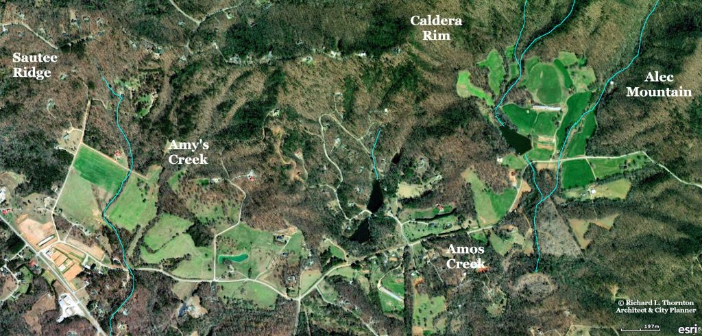
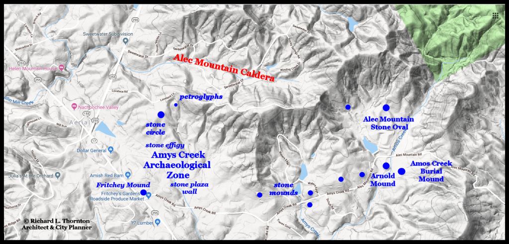
My research in the Soque-Upper Chattahoochee River Basin continues, even though we are waiting for autumn frosts to kill off the undergrowth and chase away the Copperhead snakes before hiking again up to stone ruins. This past week was a time of major discoveries in my own community. First, a property owner showed me an ancient stone retaining wall that supported a plaza in front of a long, low mound. The site has no official state site number, but also is not accessed by a paved road, so it is excusable that no archaeologist, visiting the Nacoochee Valley, would have immediately recognized it.
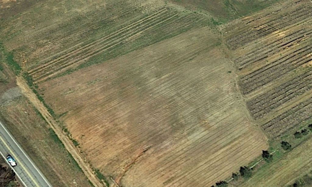
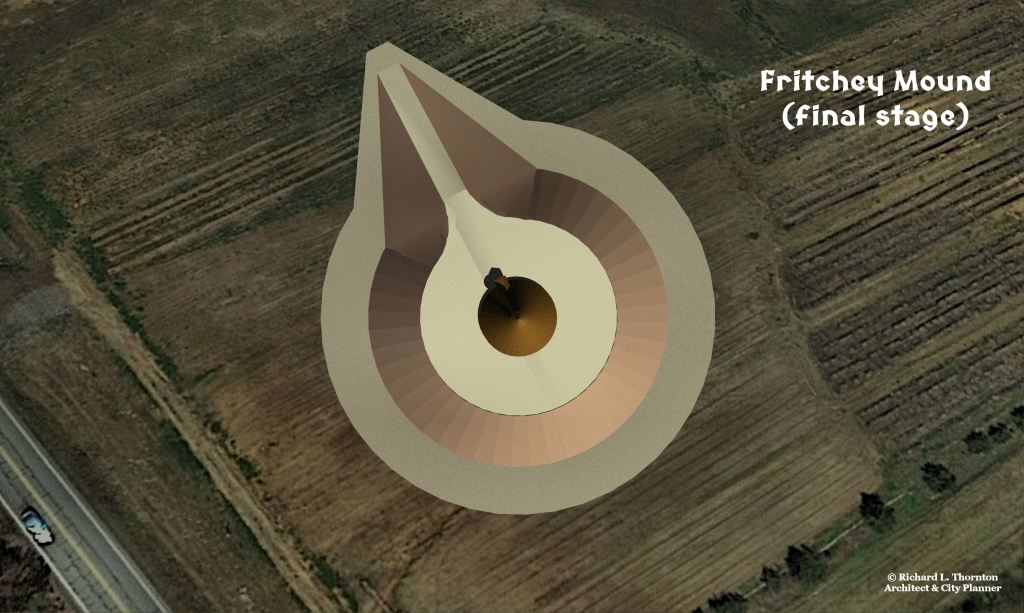
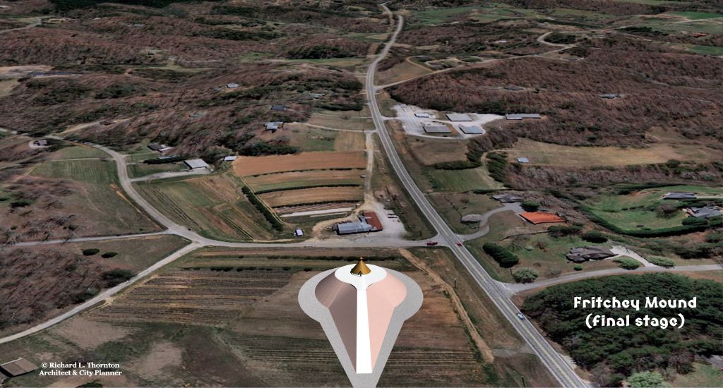
Yesterday, I stopped by Fritchey’s Farm Market to buy some fresh veggies from their farm, when I was provided some astonishing information. One of the people there mentioned that until the 1990s, an enormous mound was located at the intersection of GA Hwy. 17 and Amy’s Creek Road . . . across the street from the farm market. The people in the neighborhood, who remember the mound, said that it was about 50 feet tall, “kinda round,” and flat on top. The mound covered most of a flat field, where sweet corn is now growing. Corn grew 14 feet tall on the mound slopes and in the soil around the mound. The area, where the mound once stood, farm workers still find potsherds and broken stone tools. Many of the potsherds are polished blackware. That style is typical of the Soque in Northeast Georgia and Zoque in southern Mexico.
In the early 1990s, the Georgia Department of Transportation purchased the mound to use as top soil for highway projects in the region. In other words, the human remains and artifacts within this supposedly massive mound are now scattered to the winds. So, there is no mound to look at now. Was it really as large as the local residents described?

–
Several archaeologists visited the Alec Mountain Stone Oval during the late 1800s and early 1900s. In order to reach Alec Mountain, one must turn onto Amy’s Creek Road from GA 17. Surely some archaeologist would have been suspicious of an Indian mound-like form, rising from fairly level land, but apparently not. During the mid-20th century, Alec Mountain was a “must-see” tourist attraction in the Nacoochee Valley Area. At that time, the archaeological site, hiking trail and parking lot were maintained by a local Boy Scout troop. The Boy Scout troop was also aware of the large mound next to Hwy. 17, but apparently, it was never pointed out to either tourists or archaeologists.
There was a African-American community near the intersection of Hwy. 17 and Amy’s Creek Road until the 1970s. Here was located a post office, public school, churches and a general store catering to the African-American community. After the Habersham County Schools were integrated, the Black community sold their real estate, moved elsewhere. The post office, school and store were demolished. For unknown reasons, after Alpine Helen was developed in the early 1970s, the Alec Mountain Stone Oval ceased to be a tourist attraction and the Boy Scouts stopped maintaining it.
Finding evidence to back up a local tradition

_
A high resolution, near visible light satellite image confirmed that there had once been a large mound at that location. The soil is still slightly darker within the boundaries of the mound. There is more to the story, however. One can see much darker circles, where earlier mounds and houses had been constructed. These were covered by the large mound, which survived to the early 1990s. The original mound was about 87 feet (27m) wide, while final mound was about 250 feet (76m) in diameter.
A 1982 county-sponsored aerial photo shows the large mound in partial cultivation. A 1993 US Geological Survey aerial photograph shows the mound partially excavated with a bulldozer and dump truck working at the site. These photos support the local tradition 100%.

The scale and geometry of this mound are very close to that of Mound A at Wahashe (Rembert Mounds) which were near the confluence of the Savannah and Broad Rivers. Wahashe was 67 miles (108 km) southeast of this town in the northern territories of the Soque People. The Muskogee Creek name for the Broad River was Saukehawchee, which means Sokee River. Therefore, it was assumed that the occupants both towns were Soque. Both the Soque of the Southeast and the Zoque of Mexico primarily lived in round houses. That is what is shown on the virtual reality images, included in this article.
The Soque/Miccosukee Migration Legend states that their ancestors came from northern Tabasco State and the southern tip of Veracruz State in Mexico. They are descended from the elite of the so-called Olmec Civilization and also participated in the Maya Civilization. Soque and Zoque are pronounces Jzhō : kē. Both the Soque and Zoque were known for the polished black pottery. Obviously, they are two branches of the same ethnic group. Voluneers from Habersham and White Counties, plus Metro Atlanta, are also helping in the study of a large concentration of Soque structures and agricultural terraces around Batesville, GA, just south of Lake Burton.

It was too convenient a pile to resist, huh? Rob
LikeLike
Apparently, that was the case. There were potsherds visible in the soil as they cut away at the mound.
LikeLike
I may have a potentially undiscovered mound similar to the one you describe in the article. If you are interested, It is on private land close to Mount Yonah. Write me at stefanwessel63@gmail.com and we can talk.
LikeLike