
by Richard L. Thornton, Architect & City Planner
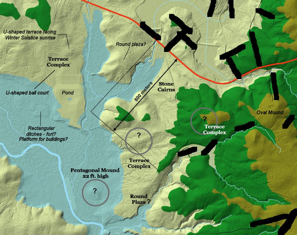
(VR Image above) A historic preservationist in Jackson County, GA tipped me off about this large Apalache (Proto-Creek) town site on the North Oconee River and gave me a photo-copy of the archaeological report that he had obtained while a county employee one summer while in college. A University of Georgia professor dug some test holes in the 1980s and gave it a site number, but had no clue of the extent of the site. He labeled the stone-walled terraces as being “early 19th century farming activities.” I used LIDAR to find all of the structures and create a computer model. The visible structures were loosely stretched for 2 ½ miles along the river! I suspect that the farmsteads were almost continuous along the river and probably few people actually lived near the mounds, irrigation ponds and stone structures. Like almost all Proto-Creek towns, this one grew for many centuries along a section of the river, where there were rapids, shoals and waterfalls.
Chroniclers of the Hernando de Soto Expedition stated that the conquistadors never lost site of houses or cultivated fields while they were in what is now the State of Georgia.
In 1947, anthropologists from around the eastern United States met at Harvard University to create an orthodoxy for the Pre-Columbian history of eastern North America. This happened to be the year after Dr. Willard Libby of the University of Chicago first proposed the concept of radiocarbon dating. However, it would be the mid-1950s before the procedures for radiocarbon dating would be standardized and the equipment for measuring it being manufactured and generally available. Thus, the attendees at the Harvard created their anthropological catechism in a chronological fog. That was the first step into archaeological lala land, which continues unto this day. Consistently, Southeastern archaeologists tend to place much more trust in what their professors taught them than in the facts.
The “High Council” of archaeology decided that”
- The first humans in the Americas were the Clovis People and that they crossed the Bering Strait Land Bridge around 8000 BC then quickly populated all of the Americas. (No Clovis points have been found in Alaska and the oldest Clovis Points are along the Savannah and Altamaha Rivers!)
- The Clovis People quickly killed off most of the large mammals in the Americas. They were replaced by “Archaic Hunters-Gatherers,” who occupied all of the Americas for thousands of years.
- Around 0 AD a “Woodland” Culture arose in the Midwest and Northeast then spread southward. It involved hunters and gatherers living in more permanent villages and making pottery.
- The first pottery was made in Ohio.
- The first mounds were built in Ohio by members of the Adena and Hopewell Cultures.
- The Swift Culture was founded in the Macon, GA area by Indians from New England, who learned how to make pottery and build mounds from the Hopewell People as they migrated southward to Dixie.
- The Hopewell People eventually moved down the Ohio River and founded Cahokia, which was the first location where corn, beans and squash were grown in North America. Cahokia became the first permanent town.
- The explanation of how corn and beans could jump from central Mexico to southern Illinois was carefully avoided. (Actually, it has recently been discovered that the Indian corn grown in Eastern North America came from eastern Peru, not Mexico.)
- Cahokia was the progenitor of the “Mississippian Culture.” Cahokia sent out missionaries around 1000 AD to surrounding areas to establish more towns, where corn, bean and squash were grown, plus large mounds were built. At this time, the people in the Southeast abandoned their small villages and moved to the large, fortified towns with large mounds. (To this day, one constantly sees articles written by Midwestern academicians, which claim that various manifestations of “sophisticated art” found in Southeastern mounds, were actually produced in Cahokia . . . even though it is now known that many large towns in Florida and Georgia long predate Cahokia!)
- There was no direct contact between Mesoamerica and what is now the United States.
- Indians in what is now the Eastern United States and Canada did not know how to build with stone. The Anasazi were the only Indians, who built stone structures.
- Indians, north of Mexico, did not have any writing systems until one was invented by the Cherokee, Sequoya, in the early 1800s.
Regional analysis tells a different story
Between 2012 and 2016, Access Genealogy paid me to research the “Native American History” of every county in Florida, Alabama, Georgia, South Carolina, Eastern Tennessee and Western North Carolina. Basically, I was taking the same approach as I would for preparing a regional or city comprehensive plan. Assemble all available data for a geographic area . . . organize it in a rational format . . . then analyze the information as a whole, interpolated body.
In Europe, archaeological reports are public record and are kept in public archives in the same manner as property deeds, marriage licenses and birth certificates. In keeping with this accepted international practice, between 2001 and 2010 virtually all recent archaeological reports in the United States were digitized and placed on the web. This was done as a convenience to professional archaeologists and anthropology students . . . with the assumption that laymen were unable to understand the reports.
As time went on, however, it became increasingly difficult to find late 20th century and early 21st century archaeological reports on the web. Beginning with the “Mayas In Georgia Thing” in 2012, thousands of archaeological reports were being pulled from the internet. They were only available from central gate-keeping offices at certain state universities, which were minimally staffed. Once my name became well known among the region’s archaeologists, the state offices refused to let me obtain copies of any archaeological reports or photographs of archaeological sites. I got around the gate-keepers by accessing posted theses and dissertations, which contained large portions of these reports.
For example, back in 2006, I was able to find online a copy of Joseph Caldwell’s 1957 report on Tugaloo Island and the Tugaloo River Basin. He found that all of the Savannah and Tugaloo River basins had been densely occupied by “Creeks” from around 200 AD to 1700 AD. Mound construction began on the island around 800 AD. That probably marks the arrival of the first refugees from the El Chichon volcanic eruption in Chiapas, Mexico. Palenque was incinerated by this volcano in 800 AD.
Georgia historical markers, official state history textbooks, Chamber of Commerce brochures, contemporary archaeologists, etc. state that “Tugaloo was the first Cherokee town in Georgia. Here, around 1450 AD the Cherokees built eight large mounds. Cherokee priests maintained sacred fires in the temples on top of the mounds, night and day.”
HOWEVER, when in 2012 I wrote an article on Tugaloo in my architecture column in the Examiner, guess what happened? The archaeological report disappeared from the web. Readers wrote me that the URL I listed for the report resulted in an error message that “this website has been deleted.” The US Army Corps of Engineers sent people on a goose chase when they requested a copy. Of course, federal law requires federal employees to furnish a copy, but they got around the law by constantly referring citizens to another office within the agency.
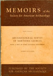
Nevertheless, I was able to purchase the LAST new copy of Robert Wauchope’s An Archaeological Survey of Northern Georgia. The soft-bound book had been printed in 1966. References such as Wikipedia describe the Southeast’s indigenous population during the “Mississippian Cultural Period” as being concentrated into a few large, walled towns with large mounds. That is not what Wauchope found.
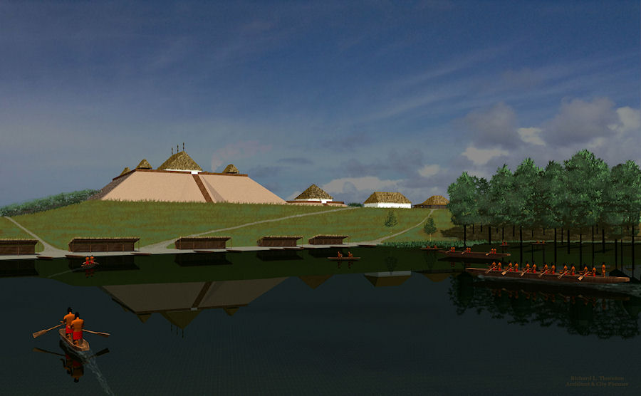
Ocmulgee National Historic Park was actually the “downtown” for a low density conurbation, which stretched for about 48 miles along the Ocmulgee River. Farmsteads dotted the landscape of Mississippi, Louisiana, Alabama, Georgia, South Carolina, Tennessee, northwestern Florida and western North Carolina. Along the major rivers of North Georgia, small villages were spaced about 3 to 5 miles apart and were occupied for many centuries. However, in the Nacoochee Valley of Northeast Georgia, Wauchope found many long-occupied villages, which were only 100 to 200 yards apart.
Large, densely occupied, walled towns were rare and always short-lived, because they were unsustainable due to the lack of animal power and wheeled vehicles for transporting heavy loads. They depleted the natural resources, in particular, firewood and animal protein. Water transportation was suitable for hauling grain and high value commodities, but could not produce animal protein or carry sufficient quantities of firewood to supply a whole town. Just think about. A large town such as Moundville or Etowah would need a dump truck load of firewood just to cook their meals for a couple of days. All that wood had to be carried on human backs . . . eventually many, many miles.
I also see evidence the overview of archaeological reports that large towns had a negative impact on the vitality overall of a region. The population of the Southern Highlands exploded during the first phase of Etula’s (Etowah’s) occupation, when the mounds were modest. Populations declined in North Georgia and Southeast Tennessee, during the period between 1250 AD and 1375 AD, when Etula (Etowah) was building a massive mound. The mound was eventually almost as big as Monks Mound at Cahokia, but was radically reduced in size in the 1800s by amateur artifact diggers.

It seems impossible to know if the decline in regional population was due to military attacks, forced relocation or slave raids by Etula. However, there is no doubt that the Lower Southeast was much more populous and economically healthy, when the bigshots at Etula were shut down. During this third phase in the so-called Mississippian Period, mounds were endemic, but not terribly large.
I think the problem is that anthropologists in the United States have been educated to have a “one theoretical model fits all” mentality. The actual situation, at least in the Southeast, was that there was no one type of Native American settlement. There were broad variations in both the size of indigenous communities and the architecture their inhabitants erected.

That 4.8 stretch along the Ocmulgee was known as “Sofkee” during De Soto’s time and it still is to this day due to the number of corn fields he found planted along the river.
On Fri, Oct 18, 2019 at 11:51 AM The Americas Revealed wrote:
> alekmountain posted: ” by Richard L. Thornton, Architect & City Planner > (VR Image above) A historic preservationist in Jackson County, GA tipped > me off about this large Apalache (Proto-Creek) town site on the North > Oconee River and gave me a photo-copy of the arch” >
LikeLike