by Richard L. Thornton, Architect and City Planner
Bottle Creek Mounds National Historic Landmark is located on an island in an estuary and tidal marsh of the Mobile River, about 21 miles north of Mobile Bay and 325 miles downstream from Etowah Mounds National Historic Landmark in northwest Georgia. It was founded around 1250 AD at the same time of the beginning of the second Mississippian Period occupation of Etowah Mounds and the sudden rise in population of the Lamar Village (Ichesi) at Ocmulgee National Historic Park. It is likely that the town at Bottle Creek replaced an earlier town on Mobile Bay, which was destroyed by a catastrophic hurricane.
Official Description
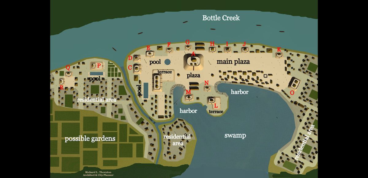
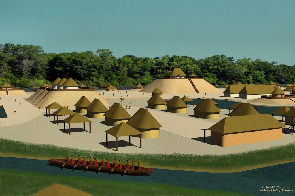
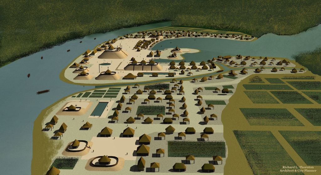
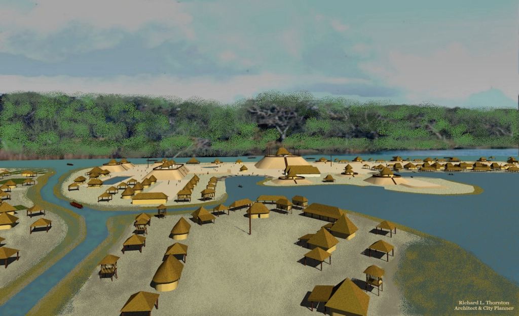
It is located on Mound Island in the Mobile-Tensaw River Delta, north of present-day Mobile, and includes 18 platform mounds, the tallest being roughly 45 feet (14 m) high. Five of those eighteen mounds are arranged around the central plaza. It was the largest Mississippian chiefdom on the north-central Gulf Coast.
The archaeological zone is impossible to reach by foot. However, it would have been easily accessed by dugout canoes, the primary mode of transportation of the peoples in the region. It lies near the confluence of the Tombigbee and Alabama rivers. The streams become a maze of branches and bayous at the head of Mobile Bay. The site was a ceremonial center for the Pensacola people, as well as a social, political, religious, and trade center for the Mobile Delta region and the central Gulf Coast.
The site was occupied between 1250 AD and 1550 AD. The town served as the focal point for interaction with other Mississippian culture areas along the coast and the interior of the Southeastern United States. It includes 18 platform mounds, the tallest being roughly 45 feet (14 m) high. Five of those eighteen mounds are arranged around the central plaza. It was the largest Mississippian chiefdom on the north-central Gulf Coast.

_
What the Gringo archaeologists don’t tell you
The regions around a Chontal Maya port on the northern tip of Yucatan, Tampico Bay in Tamaulipas State, Mexico and the section of the Gulf Coast between Mobile Bay, Alabama and Apalachicola Bay, Florida were called Am Ixchel (Amichel in Spanish). They form an equilateral triangle. Am Ixchel are Chontal Maya words that mean “Place of the (goddess) Ixchel.” There is only one possible explanation for all three coast lines having the same Chontal Maya name. Chontal Maya traders went there often and gave them the name of their patron goddess.
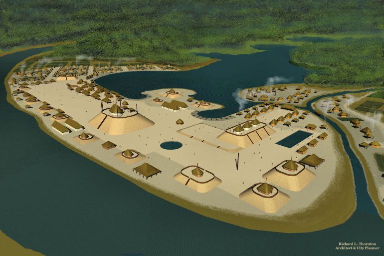
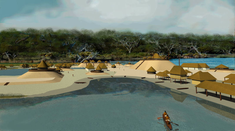
Twelve years ago, when I first saw the topographic map of Bottle Creek Mounds, I instantly recognized that the town had an almost identical layout to Chontal Maya ports in Tamaulipas and Tabasco that I had visited on my fellowship in Mexico. The Chontal Mayas only built earthen pyramids, virtually identical to those in Mississippi, Alabama and the Florida Panhandle. The earthen pyramids in Georgia, western North Carolina, South Carolina and eastern Tennessee were like those built by the Itza Mayas . . . with the exception of the oval mounds, which were a homegrown architectural tradition going back at least to 1000 BC. However, there are many more similarities.
Chontal Maya ports were placed at the mouths of slow moving rivers so that freight unloaded at the port could be shipped inland. Most had lagoons on the landward side of towns where freight canoes could be parked, but protected from ocean storms. In the centers of these towns were large plazas, which functioned as open air markets.
Etymology of Mobile: The name of a city and a river, Mobile is the French version of the Spanish proper noun, Mabilia. Mabila was derived from the Native American ethnic name, Mapile, which means “Trade People.” The “Mapi” part of the word is Totonac and Chontal Maya. it means “trade.”
Etymology of Alabama: The original spelling of this word was Albaamaha, followed by Alibamu. “Al” is Itza Maya and means “Place of.” “Ha” is Chontal and Itza Maya. It means river. The syllable “baam” is unrecognizable in several Maya dictionaries, but could well be a shortening of the word for jaguar, balam. Then the translation would be “Place of the Jaguar – River.” There WERE jaguars in the Gulf Coast region until the late Colonial Period. Richard Harlan, a contemporary of the famed naturalist James Audubon, wrote that jaguars were seen east of the Mississippi into the early 1800s. They were in the Southern Appalachian Mountains until at least 1737.
In the near future a documentary video on Bottle Creek Mounds will be posted on the People of One Fire Youtube Channel.


Amazing Richard!
LikeLiked by 1 person
Hello Richard, how do you do ?
I’m Firman from Indonesia, we have conversation back then at peopleofonefire.com (RIP).
Could you tell the recent site of this ancient town ? because when i text “Bottle Creek Mounds” the maps will show a place – an intersection – near Alabama State Dock Boulevard, does this position is correct ?
Thanks Richard.
LikeLiked by 1 person
That is the dock where you take the boat to Bottle Creek Mounds. Copy the latitude and longitude on the right side of Wikipedia article on Bottle Creek Mounds then past them in the SEARCH box of Google Maps. It will take you to the exact location of the archaeological zone.
LikeLike
wow, found it ! it’s in the middle of swamp-forrest area, the nature has reclaim it.
There’s no trace of ponds. harbor and swamp lake like your 3D rendering of Bottle Creek Site.
Do you know the real name of Bottle Creek Mounds ?
LikeLiked by 1 person
It may be Mapile, but no one really knows at this point. In order to create the virtual reality image I used a digitized topographic model to insure accuracy. Architectural virtual reality images are not “artist’s drawing” but 3D computer models equally as accurate as the drawings we produce for new buildings.
LikeLiked by 1 person
Richard, The book of “to reveal” has many understandings about what you have found. Ala-tama-ha seems to have many understandings about the Kingdom of the beast timeline.
“And I stood upon the sand of the sea, and saw a beast rise up out of the sea, having seven heads and ten horns, and upon his horns ten crowns, and upon his heads the name of blasphemy. 2 And the beast which I saw was like unto a leopard, and his feet were as the feet of a bear, and his mouth as the mouth of a lion: and the dragon gave him his power, and his seat, and great authority.” Amen.
LikeLiked by 1 person