by Richard L. Thornton, Architect & City Planner
Deductive reasoning uses algebra to dissect inscrutable words or crack cryptic codes. In these excerpts from my forthcoming book on The Native American Words of Georgia, you will see how the etymology of a creek with the strange name of Aboothlacoosta opened the door to a little understood chapter of the Southeastern United States early history.
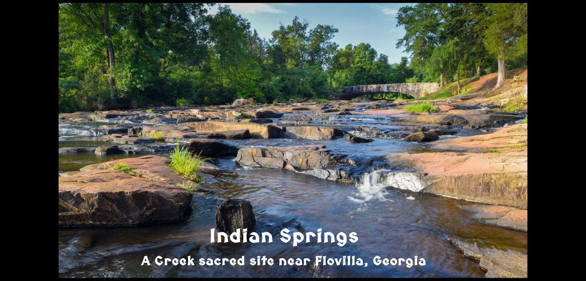
If you have never been to Indian Springs, it’s a treat you need to give yourself. Although the landscape looks like gently rolling Piedmont terrain, the springs are actually at around 1200 feet above sea level, about 200 feet above the highest point in the City of Atlanta, even though it is 46 miles south of Downtown Atlanta. The result is vegetation that looks like it belongs in the Blue Ridge Foothills. The vestiges of the Pre-Columbian occupation of the area are gone now, but there are excellent displays about the history of the Creek People in the park museum and in the Indian Springs Hotel, which was built in 1823 by a Creek mikko or chief. We will let three articles in the etymology book tell you the rest of the story.
Aboothlacoosta Creek
Aboothlacoosta Creek is a stream in Butts County, Georgia that flows into Big Sandy Creek, immediately east of Indian Springs. It is part of the Indian Springs Ceremonial Complex that once contained multiple stone altars, stone cairns, stone effigies and earthen mounds. Indian Springs was considered one of the most sacred places to the Creek People. It then became the first state park in the United States. The indigenous stone structures were used as building materials for a large 19th century resort hotels that once stood on the premises.
Etymology – Aboothlacoosta is obviously a Creek word, but bears no resemblance to any words in the Muskogee-Creek dictionary. It appears to be a word from a Creek language, older than Muskogee that has been mispronounced by Muskogee speakers then Anglicized so that it is impossible to obtain the original words from a Muskogee dictionary. Remember that the Muskogee speakers were not the original Creeks in Georgia and probably did not migrate down out of the Carolina Mountains until the 1600s.
The Muskogee speakers in the Ocmulgee River Basin greatly altered the pronunciation of old words. Here are some facts to feed into the deductive analysis of this word.
- Ocmulgee Muskogees pronounced an Itsate-Creek P almost like an English B. There is no “b” in the Muskogee Creek alphabet.
- Ocmulgee Muskogees changed a R sound to a “thl” sound.
- Ocmulgee Muskogees replaced a “tē” sound with a “tä” sound.
- 18th and early 19th century English speakers typically used a C for a K sound.
We replace the Muskogee mispronunciations and get Aparakus-te! Late 17th century French ethnologist, Charles de Rochefort wrote that the High King of the Apalache Kingdom in Georgia (forerunner of Creek Confederacy) was called the Aparakus or Parakus, while the royal family (elite) were called Aparakuste or Parakuste. Do those words sound familiar?

Yes, Paracus is what the super-tall, big-brained people of the Nazca Plain in Peru called themselves. Paracas is the Spanish version of the word. They left that region of Peru around 100 BC. Soon thereafter major cultural changes started occurring at Teotihuacan in Mexico and along the major rivers in Georgia. Recent DNA testing has revealed that the Paracus People originated along the northern edge of the Black Sea and they also were the elite of the Huns, when they invaded the Roman Empire in 451 AD.
In 1939, archaeologist Robert Wauchope discovered a large village on the Etowah River in the Allatoona Mountains of Northwest Metro Atlanta. He estimated that it contained a population of at least 1000 persons. He only dug some test ditches and holes, but was surprised to find a tall skeleton with an abnormally large skull that was either deformed or else excessively flattened as a child.
Archaeologist Joseph Caldwell hurriedly excavated the entire town site in 1947. The Allatoona Reservoir was rapidly filling with water and he didn’t have time to write a complete report on it. He was astonished to find that almost all the adult skeletons had excessively deformed over-sized skulls. Even the skulls of babies seemed too large. He concluded that the entire town’s population was afflicted with hydrocephalus (water on the brain) but that didn’t explain the large brains or tall stature of the town’s residents. The town seemed to have existed at the same time as Etowah Mounds a few miles downstream.
Realizing that any publicity on the find would attract ridicule from fellow archaeologists, Caldwell did not publicize his find. That we know at all about the discovery is due to an article in the Red and Black, the student newspaper of the University of Georgia. It should be remembered that the famous Paracas skulls of Peru were classified as victims of hydrocephalus until about three years ago.
Indian Springs
The Indian Springs Aquifer is a natural geological formation in Butts County, Georgia where Big Sandy Creek, almost the size of a river, shoots out of a rock formation then flows generally eastward to the Ocmulgee River. The ridge from which the springs flow is at an elevation of about 1200 feet (366 m). That is 200 feet higher than Downtown Atlanta and results in vegetation more similar to that found in the Blue Ridge Foothills of northern Georgia.
The water from these springs have a slight sulfur smell and metallic taste. The minerals that cause these qualities have always been thought to have curative qualities. The name of the Ocmulgee River probably was the original name of the springs. (See Ocmulgee River.) The locations of the famous Creek towns of Coweta and Cusseta were at the confluence of Big Sandy Creek and the Ocmulgee prior to 1717.
Indian Springs was considered one of the most sacred places of the Creek People. It is here that they held diplomatic conferences with both British officials and later representatives of the United States and Georgia. The area around Big Sandy Creek and Aboothlacoosta Creek once contained many stone altars, stone cairns and earthen mounds. These were all used in the construction of a resort hotel in the mid-1800s.
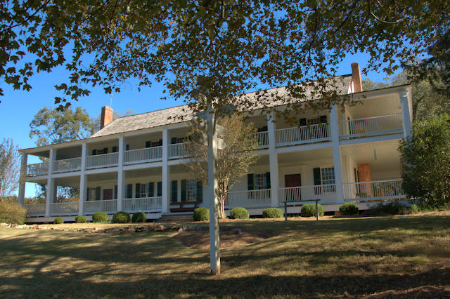
The Indian Spring Hotel was built in 1823 as an inn by Creek Mikko (Chief) William McIntosh and his cousin, Joel Bailey, who also operated it. In 1825, a two-story addition was built. The addition included the tavern known as the Treaty Room and a large ballroom above it. The hotel is unique and extremely significant to the history of the United States and Georgia. The hotel has been fully restored and is open to the public.

Resort hotels sprang up and from the mid-1800s through the early 1900s a variety of hotels, some as large as 700 rooms, graced the area known as McIntosh, and later Flovilla. Thousands flocked to the area and the tourist industry thrived until changing economic conditions and other factors brought an end to the “Gilded Age.”
Many of the hotels had burned, fell into disuse or were torn down by the 1920s. In 1927, just two years prior to the stock market collapse, the State of Georgia officially named the property Indian Springs State Park, making it Georgia’s oldest state park.

The difficulty of the depression gave rise to President Roosevelt’s “New Deal” and the origin of the Civilian Conservation Corps (CCC). Company 459 came to Indian Springs and the CCC “boys” built the stone structures that still grace the land around the spring. The CCC boys are largely responsible for providing the infrastructure on which the modern park is built.

Indian Springs State Park is a 528-acre (2.14 km²) Georgia state park located near Flovilla in Butts County. The park is named for its several springs, which the Creek Indians used for centuries to heal the sick. The location was also where councils of the Creek Confederacy were held. It was acquired from the Creek Indians by the state through the fraudulent Treaty of Indian Springs (1825) and the ratified Treaty of Washington (1827).
Indian Springs is the oldest state park in the nation. Since 1827, Indian Springs has been operated continuously by the state as a public park, although it did not gain the title “State Park” until 1931. The area became a resort town in the 19th century. It became an official “State Forest Park” in 1927. In 1931, along with Vogel State Park, it became a founding unit of Georgia’s state park system.

Ocmulgee River
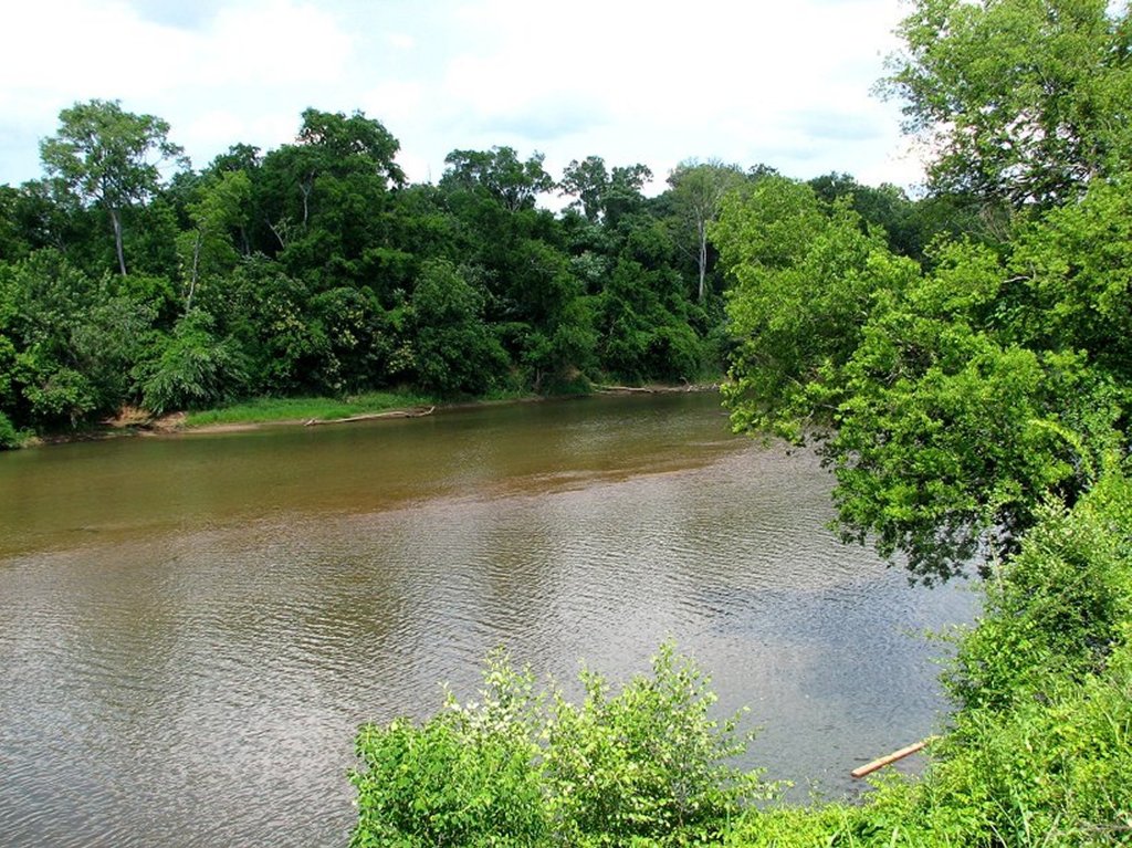
The Ocmulgee River is a western tributary of the Altamaha River, approximately 255 mi (410 km) long, in the U.S. state of Georgia. It is the westernmost major tributary of the Altamaha. The Ocmulgee River and its tributaries provide drainage for some 6,180 square miles in parts of 33 Georgia counties, a large section of the Piedmont.
The river rises at a point in north central Georgia southeast of Atlanta, at the confluence of the Yellow, South, and Alcovy rivers. Since the construction of the Lloyd Shoals Dam in the early 20th century, these rivers join as arms of the Jackson Lake reservoir. The river’s source is formed at an elevation of around 930 feet above sea level. The Ocmulgee River flows from the dam southeast past Macon, which was founded on the Fall Line. It joins the Oconee from the northwest (241 miles downstream from Jackson Lake) to form the Altamaha near Lumber City.
Dubious Etymology – [Wikipedia] The name of the river may have come from a Hitchiti words oki (“water”) plus molki (“bubbling” or “boiling”), possibly meaning “where the water boils up.” *There is no such Creek word as molki! Some academician long ago made the story up and no one (except me) has fact-checked them since then. The Creek word for to “bubble or boil” is morketaw.
Etymology – Ocmulgee is the Anglicization of the Itsate Creek words, Oka-mole, which means “Water – swirling outward from a hole” A2 plus the Muskogee Creek suffix for “people or tribe,”. . . kgi. It probably originally was the name of the springs of Big Sandy Creek in Flovilla, GA (See Indian Springs, GA).

Richhard, 100% correct about the mega brain “Para” people of Egypt, Georgia, Europa, South A-mer-ica, Mesaamerica, China (12,000B.C), the “Ala-ge-we”/ Huns of Ohio? who were the medicine man people of many lands long ago. What could have caused them to have that mega brain? Perhaps ancient DNA research. Why did someone put a “Eagle eating a snake”… “Kan peope” on their Euro money and the Mexican flag? The Kan-ani peoples had arrived long ago to the Mediterranean Sea and then back here. The “feathered serpent cult” of Mexico was a mixed peoples.
LikeLiked by 1 person
Richard, another connection to the symbol Eagle/snake was used by the Romans in London. The connections of when Romans knew of this landmass has to be before the Druids over here were wiped out. Perhaps the Aztecs had some connections to a city that the Britton/Romans had in the Americas. Their Aztec artwork shows them leaving from a island… Newport Rhode Island? Lots of roman coins found in the North East according to Dr. Berry Fell’s book. Aztlan! “The place of whiteness”.
https://www.dailymail.co.uk/sciencetech/article-2478904/Roman-sculpture-eagle-devouring-serpent-unearthed-London.html
LikeLiked by 1 person