by Richard L. Thornton, Architect and City Planner
Most of the soil in this cultivated field just shouldn’t be there!
Between 1859 and 1986, some of the most famous archaeologists in the United States rode a horse or drove a car along the 30 mile (48 km) route between the famous Nacoochee Mound, the little known Alec Mountain Stone Circle and the somewhat known Tugaloo Mounds at the headwaters of freight canoe transportation on the Tugaloo River, without noticing a massive mound, directly adjacent to an ancient trade path, now known as the Unicoi Turnpike. The mound was so large, they assumed it was a natural hill. Their names included Charles C. Jones, Cyrus Thomas, George Heye, Warren Moorehead, Robert Wauchope, Arthur Kelly, Lewis Larsen and Joseph Caldwell.

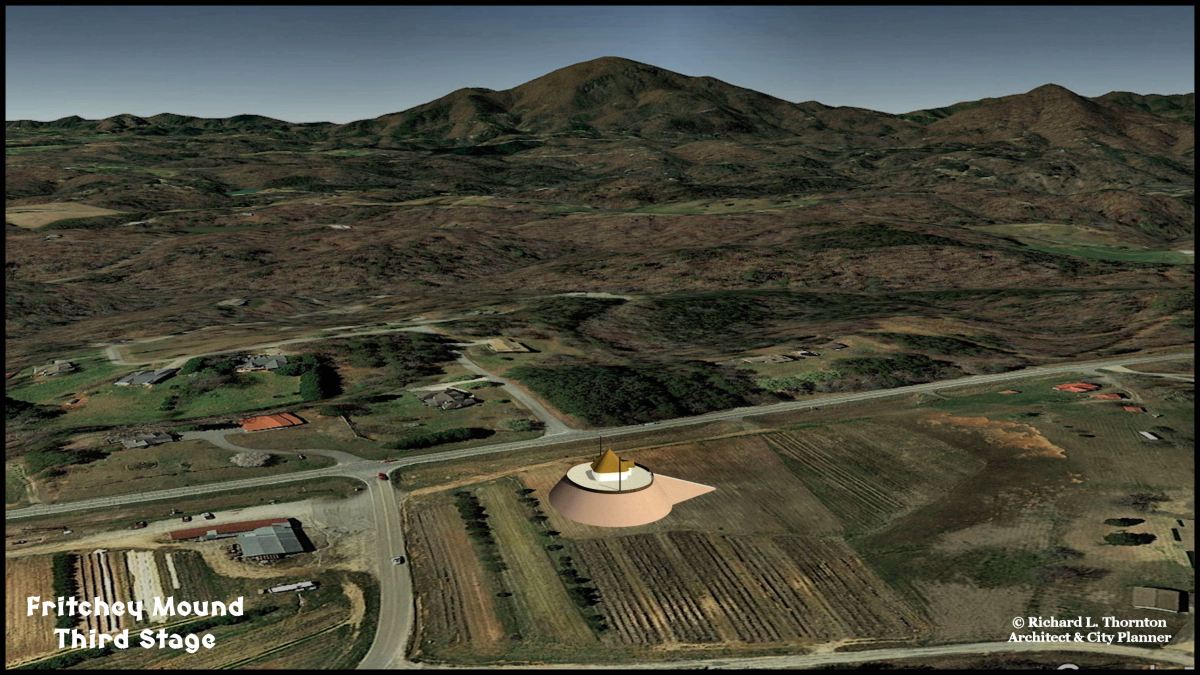
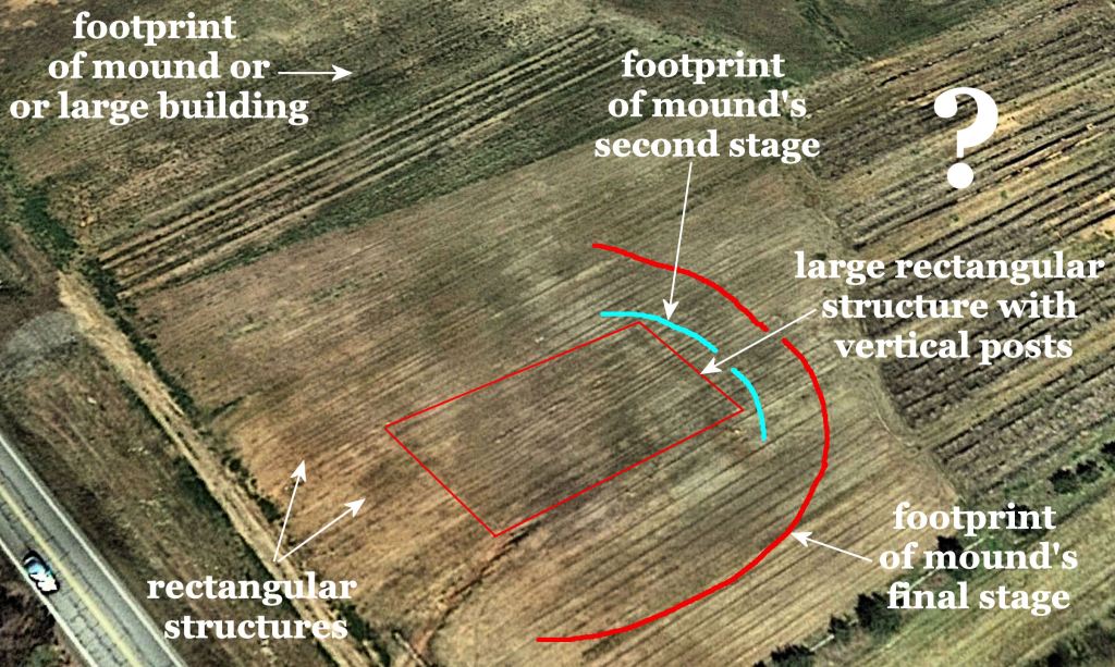
In 2019, The Americas Revealed introduced to readers the Fritchey Mound Complex. It is part of the Alec Mountain-Amy’s Creek Archaeological Zone in northwestern Habersham County, GA. Habersham is in the extreme northeastern corn of the Peach State. Actually, the mounds were hauled away in 1993 by the Georgia Department of Transportation to use as land fill for highway construction. However, with an infrared camera, one can see multiple layers of mounds and rectangular structures. What is really surprising, though, is that the dark rectangles of ancient rectangular buildings in the native red dirt are completely invisible to the naked eye. See “The Mysterious Town on Amy’s Creek” video below.
The “feeling” of the Amy’s Creek and nearby Batesville, GA Archaeological Zones is remarkably like several of the ancient towns in southern Mexico, incorrectly labeled the “Olmec” Civilization. They all were built on rolling hills, drained by small creeks at the feet of ancient, volcanic mountains. The Olmec city of La Venta is an exception, since it was built on an island in land of marshes.
More accurately, the Olmec Civilization should have been labeled the Soque Civilization, for the Soque (or Zoque) were the progenitors of this remarkable culture. They later gave their name to a beautiful whitewater river in northeast Georgia, the Soque River. In fact, the original name of Batesville WAS Soque. The direct descendants of the Soque are the Miccosukee of Florida and the Thlothblocco Creek Tribal Town in Oklahoma.
Many people asked me where did the Native Americans get the dirt to build a 30+ feet (10m) high mound that covered about two acres? I couldn’t answer. There is no obvious barrow site in the Amy’s Creek Archaeological Zone, but at least a dozen mounds. Most are not nearly as large as the Fritchey Mound, however.
This past weekend, while I was buying produce at the Fritchey Gardens Market, a farmer (keeping a legal eight feet away) told me that he wanted to show me something in the field, I found the footprints of the mounds and buildings. He had plowed up stones that didn’t look like any that one sees on the ground surface along Amy’s Creek.
We walked across the newly plowed and smoothed out corn field. I was looking at the rocks at a distance, when my feet felt something different. The soil beneath me had a different texture and color than the reddish earth at the edge of the field. Explanation . . . It’s a “farmer” thing. I was a professional farmer in the past . . . in fact, one year was US Soil Conservation Service Farmer of the Year.
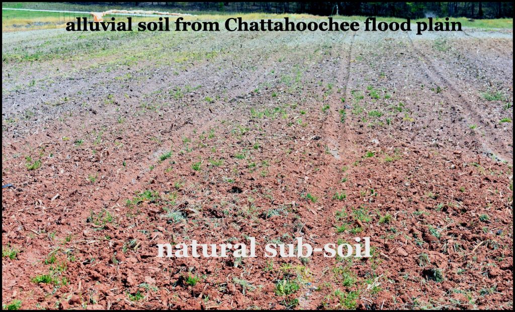
The soil that was beneath my feet should not have been there. It was soft and “spongy” like classic river flood plain alluvial loam . . . the type soil that Native Americans preferred, because it could be tilled with a hoe and was extremely fertile . . . especially liked by corn.

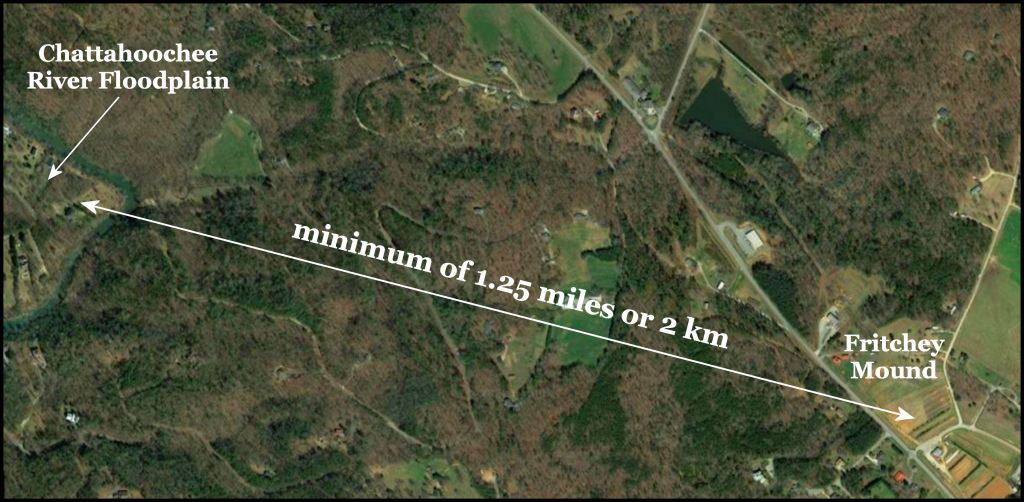
It was only then that I looked down rather than at the rocks and noticed that the spongy soil was a distinctly different color than the natural reddish sub-soil, also being cultivated on the edge of the corn field. Allan (the farmer) responded that it was this soil, which made it possible to grow two crops of sweet corn a year on the same ground. He agreed that it was identical to the fertile soil along the Chattahoochee River, which was at least 1.25 miles (2 km) to the south . . . but had no explanation.
This bottom land soil was on a hilltop, excavated at least a thousand years ago to be a flat, five acre terrace for farming and developing a ceremonial complex. First, a large rectangular building was constructed, which was oriented to the Winter Solstice Sunset. On top of the building’s ruins were constructed a series of three successively larger mounds that were oriented to the Winter Soltice Sunrise. There were also numerous rectangular buildings, the scale of houses, plus some smaller round mounds.
The very special soil of the Nacoochee Valley began as a lake, which then turned into a marsh, which then were subject to many centuries of annual spring floods. I photographed the alluvial soil at the Fritchey Site then a freshly plowed cornfield on the Chattahoochee River near the Kenimer Mound . . . three miles (4.9 km) to the northwest. The soils were identical and totally unlike the reddish upland subsoil that surrounded the Fritchey Site. There could be no other explanation, humans hauled a vast quantity of Chattahoochee alluvial soil at least 1.25 miles (2 km) on their backs to build those mounds and create fertile gardens on a hilltop terrace.
The rocks, exposed by plowing also did not belong there. The natural fieldstones in the Amy’s Creek Valley are a tan-colored rhyolite. The rhyolite was created by an ancient caldera volcano, which was about 11 miles in diameter. The banded rock, which was used for building foundations near and underneath the Fritchey Mound, was created by multiple layers of lava. Those rocks are found about 400 feet above the mound site on the crest of Alec Mountain. The rocks each weighed 60 to 100 pounds (27-45 kg). They were either carried on the backs of laborers or in slings, carried by pairs of laborers.

Prior to writing this article, I returned to the Fritchey Site to obtain higher quality photographs of the soil and field. Just by chance, I stumbled upon an obsidian blade. It is quite common to find obsidian chips and blade on the eastern end of the Nacoochee Valley. They are local in origin. This portion of Georgia was a violent volcanic zone for eons. Chimney Mountain near Batesville, GA still emits hot steam from time to time, killing the trees on the ancient volcano’s crest. I have found fairly young lava bombs in my top soil and old volcanic ash underneath the top soil at several locations.
Wouldn’t you love to have a time machine?
