
by Richard L. Thornton, Architect & City Planner
Dixie’s anthropology professors never bothered to translate the names of provinces, tribes and towns on the South Atlantic Coast before creating a simplistic geographical model of the past. Florida academicians have an additional cross to bear. In anything they publish, they have to put Georgia tribes about 100 miles farther south in 1565 then have them mysteriously disappear when St. Augustine was built the next year. The reason is that all Spanish, French, English and Dutch maps placed Fort Caroline on the south side of the mouth of the Altamaha River IN Georgia. In 1776, explorer William Bartram visited the ruins of the Spanish fort that replaced Fort Caroline on the Altamaha River then mentioned the visit in his famous book .
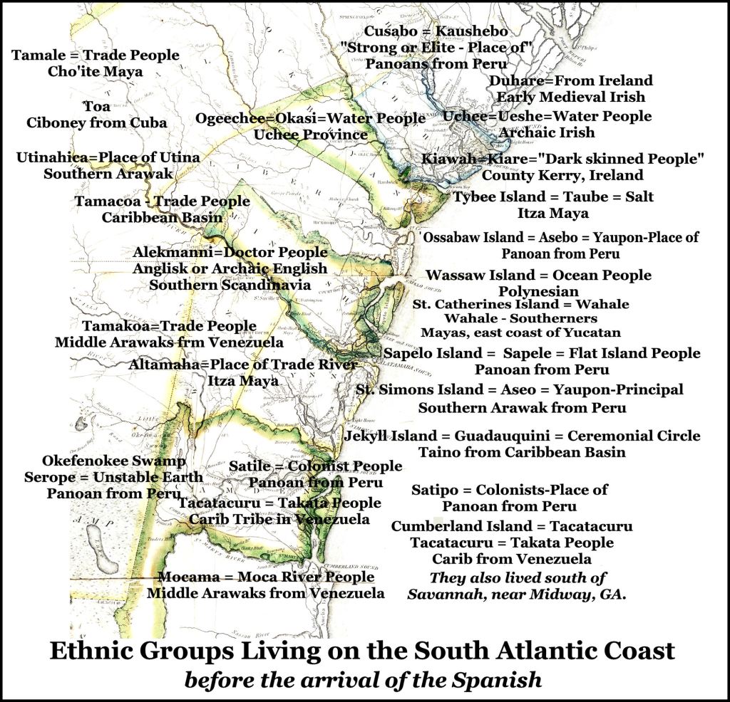
No region in North America or Mesoamerica has a more complex ethnic history than the South Atlantic Coast. When I was doing the research for my about-to-be-published book, The Native American Words of Georgia, a disproportionate time was spent trying the unravel the ethnic identities of the 110 long strip of coast line in Georgia. I had to order more and more dictionaries from Amazon.com to accomplish that task. As the same time, I was looking at the South Carolina Low Country. That task was equally daunting.
Here is the list of dictionaries I had to use, in order to translate the original geographical names in that region . . . starting with Gamla Norska ~ Old Norse for Winyah Bay, SC: Bronze Age Irish, Early Medieval Irish, Southern Siouan, Panoan (Peru), Itsate Creek, Apalachicola Creek, Southern Arawak , Middle Arawak, Northern Arawak), Carib, Taino, Tupi, Itza Maya, Yucatec Maya, Cho’ite Maya, Warao, Timucua and Archaic Anglisk (language spoken by Angles before they invaded England.
I also had to use an Indo-European Cognate Dictionary. The majority of words in Muskogee, Uchee, Panoan and Siouan have ties to Eurasian or Indo-European languages. I could find no similarity between these languages and those spoken in eastern Asia. Totonac and Itza Maya seem to be Pre-Indo-European languages. I suspect that the ancestors of the Creeks, Siouans and Mayas were Asians, who crossed directly over the ice sheets from northeastern Siberia or Russia to reach North America. Thus, for a period of time, they were living near the ancestors of the Indo-Europeans.
There are SIX pages of words, having to do with water in the Muscogee-Creek dictionary, whose root is “akwa.” Of course, phonetically that is the Latin word for water, aqua. Yet, the primary Muskogee word for water is ue, which happens to be the word for water used in Bronze Age Ireland, Scotland and western France. The modern French word for water, eau, is derived from this word.
This will blow your minds. The suffix for a tribe or people in Algonquian, Iroquoian, Cherokee and Muskogee, a “ge” sound, is also the word used in modern Irish Gaelic today, with the same meaning. Several of the tribal divisions of the Creek Confederacy had names, which are tribes, cities or counties in Ireland today.
On the other hand, Panoan in South America, has several basic words that sound the same and mean the same in modern Swedish, Danish and Norwegian. Itza Maya seems to be a combination of Panoan in Peru and Totonac in Mexico. The Totonacs ruled the Itza Mayas from around 200 AD to 600 AD.
That a wealthy tribe on the Altamaha River and in the Northeast Georgia Mountains could have an Archaic English name seems implausible, but actually was undeniable. Captain René de Laudonnière, commander of Fort Caroline, stated that the word Alecmanni meant “Doctor People.” Alec is also the Creek word for medical doctor. Alecmanni would also mean Doctor People in archaic English. Manni was the plural for man, when it applied to nobility. Leka is the Indo-European root word for herbs. It is found in many European languages. In English it still appears in the name of a vegetable with supposed medicinal qualities . . . leeks.
Below is the ethnic map of the South Atlantic Coast for about the year 1500 AD.

There’s to all of your Amazing and Awesome research Richard. You keep finding pieces of the Giant Mystery Puzzle of the Southeast and are giving us a more refined Truthful fascinating version of our history. I am firmly behind you and your research. It assists me in my search and understanding for my heritage. My heritage is intertwined with the ancient history of these here parts of the Appalachian Highlands. Thanks for taking us along with you by crafting your posts.
LikeLiked by 1 person
Be careful! So many complements in one day might make me egotistical by this afternoon! LOL Seriously, thank you for your continued support.
LikeLike
Consider me a customer for your book!
LikeLike
Hope I’m properly replying. I enjoy reading your articles. In this one you state: they have to put Georgia tribes about 100 miles farther south in 1565 then have them mysteriously disappear when St. Augustine was built the next year. The reason is that all Spanish, French, English and Dutch maps placed Fort Caroline on the south side of the mouth of the Altamaha River, about 11 miles inland.
I have gotten into a public discussion with a Jacksonville publication concerning the location of Ft Caroline. Could you possibly give me more information about the Spanish, French, English and Dutch maps mentioned above ?
Thanks,
Joe Muller Jacksonville
>
LikeLike
Joe, all of those maps, dozens of satellite images and a lot more are in my book, Fort Caroline, the Search for America’s Lost Heritage. You can get the Adobe PDF version in full color for $15 from my publisher, Lulu.com. Otherwise, google maps of La Florida and North America from 1566 to 1721. All of them show Fort Caroline to be on the Altamaha River in Georgia and the Satiuriwa Indians to be immediately south of the Altamaha and the Alecmanni to be immediately north. In his memoirs, the captain of Fort Caroline specifically stated several times that the May River began just south of the Appalachian Mountains then flowed in a southeastern direction to the Atlantic. That couldn’t possibly be the St. Johns . . . which was not opened to ocean-going vessels until being dredged in 1859. Did you know that? For several decades the Spanish didn’t even know that the St Johns existed, because its mouth was a marsh. .
LikeLiked by 1 person