
by Richard L. Thornton, Architect & City Planner
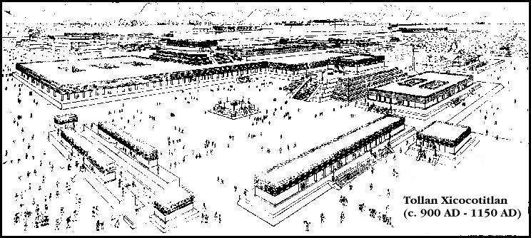
Edo. de Hidalgo ~ 850 AD-1150 AD
One Summer In Mexico – Part 23

From my Mexican Journal
Tuesday July 7, 1970 Beautiful AM Rain PM
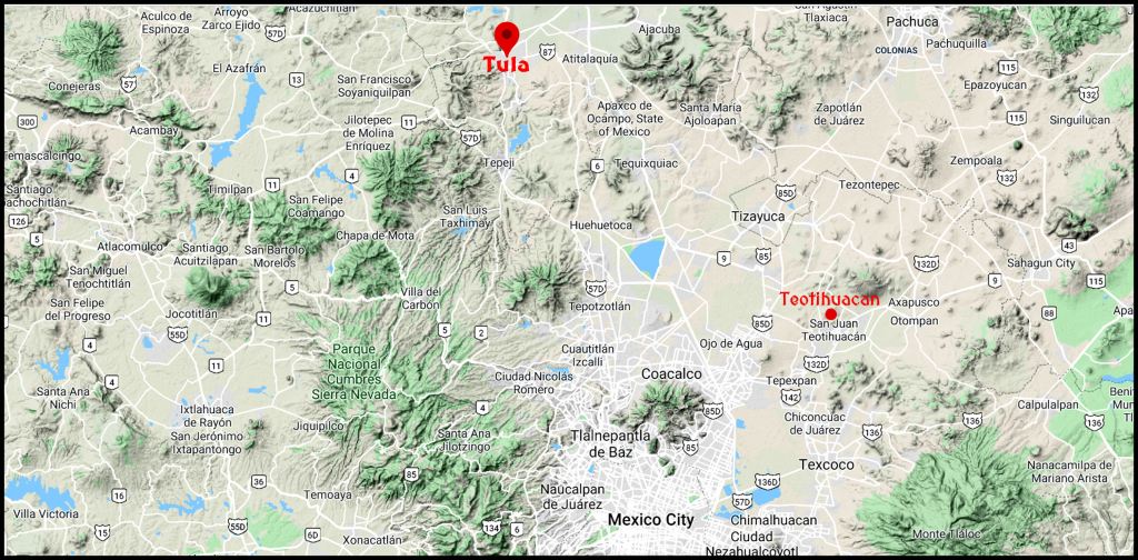
Today was another heavy day. Sr. Soto, his best friend and I went up to the ruins of Tula, about 90 miles of the Distrito Federal. The western part of the town, called Tula de Allende is the border between the states of Mexico and Hidalgo.
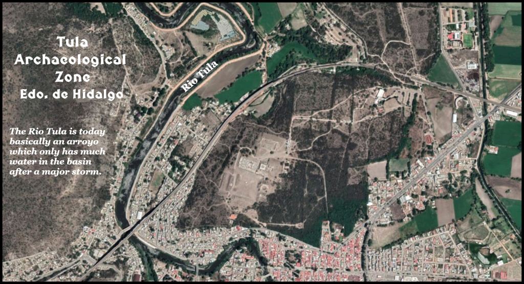
The city is at a magnificent location. However, the area is far more barren than the Valley of Mexico. There is today no adequate source of water in the near vicinity of the ruins to support a large population and agriculture. What they call the Tula River is really just an arroyo. I only saw a few stagnant pools of water. Most of the river bed is covered in shrubs or sand.
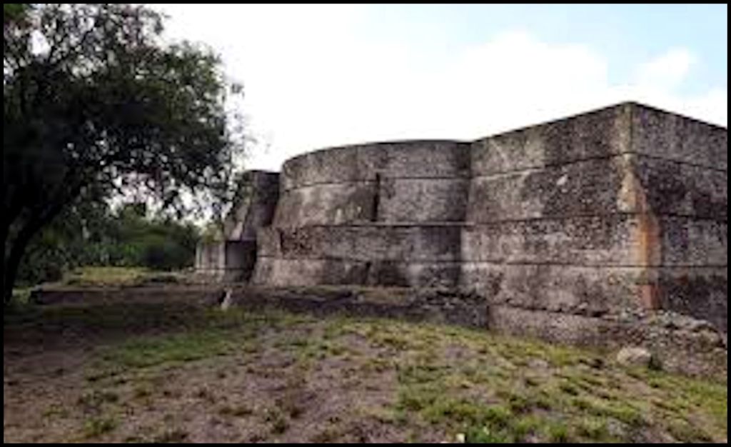
The site of Tula could easily be fortified. Also, there are still several masonry drainage systems that are fully functional. That would never happen in Georgia, where we have so many trees that shed leaves in the fall. Dr. Piña-Chan thinks that these drains lead to a giant underground water cistern, but so far, archaeologists have not been able to find it.
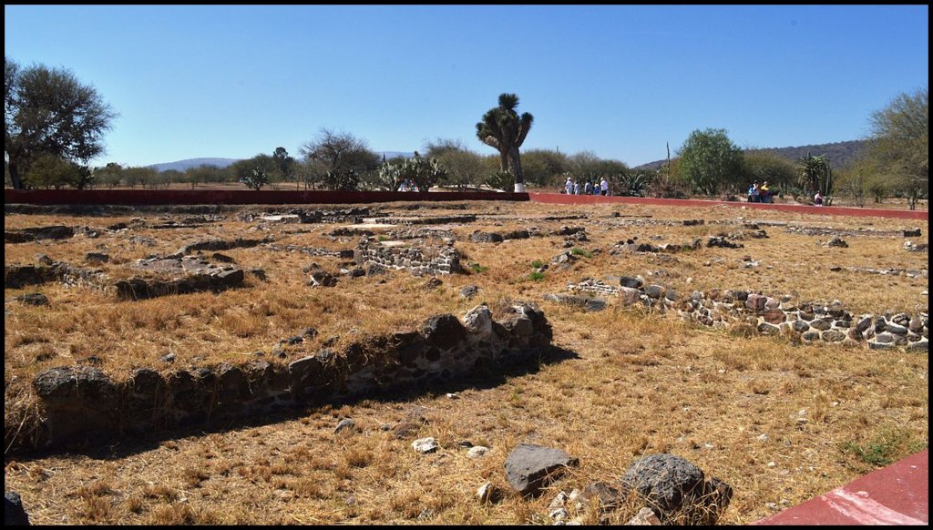
There are many dirt mounds here that look no different than the mounds in the Southeast. The archaeologists believe that even the stone veneered pyramids began as earthen pyramids.
It is thought that civilization in this region rose from the need to irrigate crops with stored rain water. The details of the architecture, planning and construction of Tula are in the INAH guide book for Tula.
Wheeled animal toys! In the local newspaper was an article about the University of Missouri archaeologists finding wheeled animal effigies – probable toys, but who knows? – in the round mound dedicated to the God of the Wind. They believe the wheeled animal effigies were mass produced in molds. Why would they know how to mass-produced wheeled toys, yet never think of using full size wheels for moving objects. Maybe they did and the wheels have not been found.

Etymology of the words, Tula, Etowah and Tollan
The etymology of Tula and Toltec, provided by Wikipedia and several anthropology books, printed in the United States, is absolutely wrong. The Gringo anthropologists keep on copying each other rather than examining the indigenous languages of Mexico. The false etymology described Tula as originally being an “Aztec” word for a type of reed, when in fact, the word, Tula, long predates the arrival of the Nahuatl speaking peoples to Central Mexico.
Tula became the word for town in Totonac, Itza Maya and Itsate Creek! It is derived from the Maya word for a type of architecture, involving the stacking of stones, taulum. Tauli is the Itza Maya, Itsate-Creek, Chickasaw and Choctaw word for stone. Talli means to plan or survey a town in Itza Maya and Itsate. A talliya was a Creek architect-surveyor.
Etowah is the Anglicization of the Muskogee Creek word Etalwa, which was derived from the Itza Maya and Itsate-Creek word, Etula. Etula means “Principal Town.”
Tollan was the Mexica (Aztec) word for Tula. Tula was probably abandoned before the ancestors of the Aztecs arrived, but they may also been one of the tribes that swarmed over the Kingdom of the Toltecs and insured its collapse.
What we now know about the climate back then
While the period between 850 AD and 1150 AD in the heartland of the Maya civilization was one of extreme drought and the jungle slowly repairing itself, farther north in Central Mexico, the Four Corners region of the US Southwest, plus Georgia and Florida, it was a warm, moist time ideal for the cultivation of corn, beans, the squash family and sunflowers. When a severe drought appeared in the northern edge of Mexico and what is now the western United States, thousands of Chichimeca hunter-gatherers fled southward into central Mexico, destroying many civilizations.
Current explanation of Tula by academicians
Alba Guadalupe Mastache and Robert H. Cobean have directed a long-term interdisciplinary project in the Tula region. As Professor-Investigators at the Instituto Nacional de Antropologia E Historia, they have published previous monographs on the archaeology of Tula including “Tepetitlán: A Rural Household in the Toltec Heartland.” They have found fairly solid proof that the Tula site was occupied by small villages prior to being developed into a great capital.
I have noticed that the current generation of academicians continue to use the “Tollan” name for the city, which is a Mexica word – impossible since the word, Tula, was in Totonac and Itza Maya long before the Aztecs arrive.
Most readily accessible references still state that Nahuatl-speaking Chichimecas settled Tula, then later on state that recent archaeological works places the human settlement of the site beginning around 400 AD. This is far too soon for the Chichimecas. The academicians copy each other on these statements, but seem to forget that the Chichimecas were very primitive hunter-gatherers, who lived in wickiups, made of fallen, dead limbs, like the Apache. There is no way that they could have instantly developed the technological skills, upon arrival in Central Mexico, to build some of the most sophisticated cities in Pre-Columbian America.
What the indigenous peoples say
The traditional explanation of Tula by indigenous peoples in Mexico state that the Toltecs originated in the Tepotztlan region of Morelos, next to the Copper Mountains. They state that the first “city” in Mexico was built near Tepotztlan and that around 850 AD a king from that region led his band of people to the Tula site. The people from Tepotztlan built the Tula Chico complex. A political faction was exiled around 950 AD then traveled to the Gulf of Mexico, before disappearing across the waters of the Gulf.
The research that I have done on southern Mexico and in the Southeast during the past 15 years tends to support the Indigenous version of Tula’s history. The chronology is absolutely in sync to connect the appearance of new cultural influences in the Mid-South and the political turmoil in Tula. These will be discussed in Parts 24 and 25.
The architecture of Tula
The city is aligned at 17 degrees east of true north, similar to structures at Teotihuacan although the first town was aligned with true north between 700-900 AD.
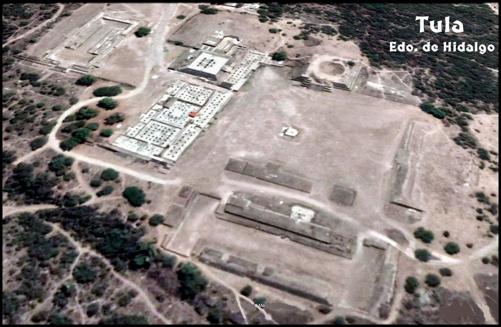
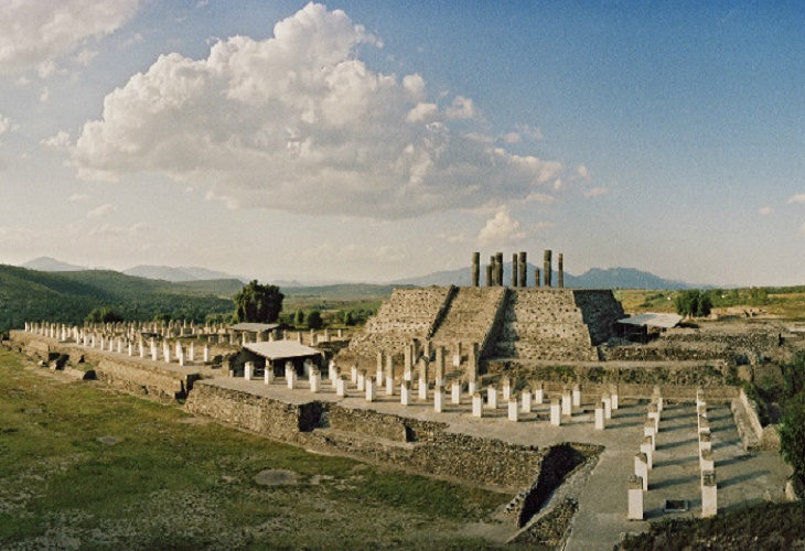
The buildings of Tula were concentrated in two clusters at opposite ends of a low ridge. Most tourists only see Tula Principal, but there is also a Tula Chica (small). Recent surveys by the INAH indicate that the original urban area covered at least 3 square miles (some 8 square km) and that the town probably had a population in the tens of thousands. The major civic center (which receives the majority of tourists) consists of a large plaza bordered on one side by a five-stepped temple pyramid, which was probably dedicated to the god Quetzalcóatl. Other structures include a palace complex, two other temple pyramids, and two ball courts. Another large civic center stands at the opposite end of the ridge.
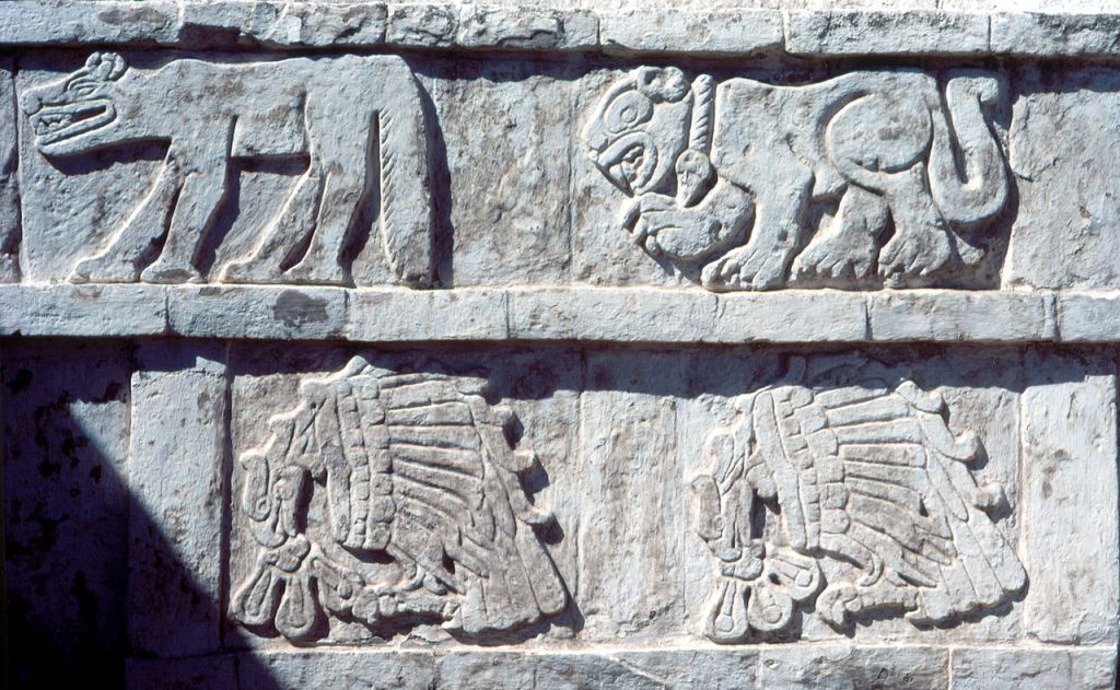
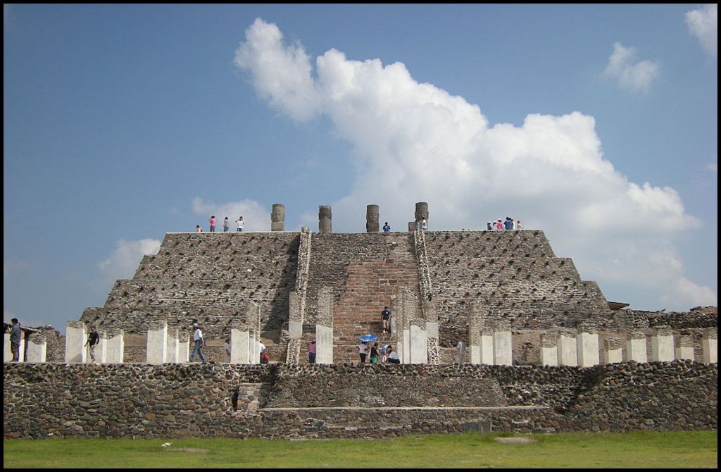
The main temple pyramid and its associated structures epitomize the stylistic characteristics of Tula architecture. Though small, the pyramid was highly decorated. The sides of the five terraces were covered with painted and sculptured friezes of marching felines and canines, of birds of prey devouring human hearts, and of human faces extending from the gaping jaws of serpents. A stairway on the southern side led to a highly ornamented two-room temple at the summit.
The front room was supported by four columns in the form of erect, stiffly posed warriors, each 15 feet (4.6 meters) high and adorned with a series of highly specific body ornaments and accoutrements representative of the Tula style. Attached to the southern base of the pyramid was another feature of Tula architecture—great colonnaded masonry hallways with flat roofs supported on scores of masonry columns.
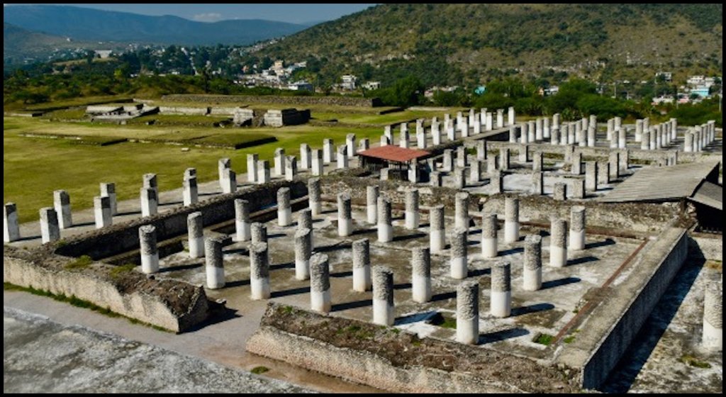
Separated from the main temple pyramid by a narrow alley are the partial remains of what may have been the palace of the ruler of Tula. The excavated portions consist of three great halls. Each apparently had a low bench placed along the interior walls (with projecting thrones at the midpoints), a central sunken light well, and great numbers of columns for support of the flat wood and masonry roof.

Howdy, Synchronicity!!! Having never been to Tula and only seeing photos of the Warriors…there was no way for me to connect Chimalacatlan in Morelos. I did do some more reading and found the Balsas River starts in the area of Chimalacatlan. Excellent article!!!!!!!!!!!!!
On Fri, Aug 7, 2020 at 9:24 PM The Americas Revealed wrote:
> alekmountain posted: ” by Richard L. Thornton, Architect & City Planner > Edo. de Hidalgo ~ 850 AD-1150 AD One Summer In Mexico – Part 23 Terrain > Location Map for Tula, Teotihuacan and Mexico City Satellite image for > archaeological zone and surrounding town Th” >
LikeLiked by 1 person
Thank you! Tell us more about the Chimalacatlan. Inquiring minds want to know
LikeLike
Richard, For some reason many connections to Egypt is what I see of the Toltecs Architecture. They have headgear with ear protectors like the Sokee (Olmecs) and also some tribes in Peru (Para). I think they extended into the Oklahoma area based on the “Tula” people term being used by the De Soto men (1540’s). This leads us to the connections of the “Para sized” head people for all 3 locations.
LikeLike
P.S. have you been told 70% of the men of Britton (Bri-tani) are related to the ancient Egyptians? Seems like a connection of many Native South East peoples that stated they arrived from “the land of the rising Sun” were right. You can follow the term “Tani” from the Black Sea…to the Middle East…Egypt…Spain…Scotland with Bronze / Iron age maps information these days. The Greeks put an “S” on many of these cities.
LikeLike