by Richard L. Thornton, Architect & City Planner
Chiefdoms are anthropological myths
Linguistic analysis and eyewitness accounts describe an entirely different ethnic landscape than what has been taught to generations of Social Studies and Anthropology students.
Creek Brother, Ric Edwards, called yesterday as he was waiting in line to order hamburgers and French fries at a Sonic fast-food restaurant in Alpine, TX. That’s when he always calls me. Not sure of the psychological significance of the connection between Sonic fast-food hamburgers and me, but it is a fact in our case.
Most of you probably don’t know Ric, but he was a founding member of the People of One Fire in 2006 and actually was the person, who suggested its name. He recommended that I apply for a position with the Examiner exactly five days before I unexpectedly was evicted from my home. The Examiner income kept me alive while I was in a tent, but also became the starting point for my Native American research. I sent in articles from local library computers – wherever I was camping. Ric was also the person, who suggested that I write a properly-researched book on the etymology of Native American place names in the Lower Southeast.
We are mutual friends with Judge Emeritus Patrick Moore of the Muscogee-Creek Nation. Ric grew up in SE Alabama. His wife, Julie, looks like a Creek princess, but is actually Latin American – perhaps carrying some DNA from an indigenous tribe, south of the border, that was related to the Creeks.
An ethnic Brunswick Stew
Ric is now reading the book that he asked me to write and has been taking special note of the many ethnic groups that lived in close proximity to each other in the Creek Homeland prior to Columbus. The first thing he said, when I answered the phone was, “Richard, those anthropology professors got it all wrong, didn’t they? Many different peoples once occupied the South and they had to get along to survive. Constant warfare was the last thing that they wanted. They needed to be able to trade in order to survive.”
“Yep!” I answered, “And the weird thing, Ric, is that all the early explorers of the Southeast . . . De Soto, De Laudonniére, Pardo, Brigstock, Lawson, described a multi-ethnic landscape, but the academicians ignored the documents that they translated back in the 1980s.”
“Lawson’s book has been around for 300 years, however. He specifically stated in 1700 that virtually every village along the Santee River in South Carolina spoke a language that was mutually unintelligible to its neighbors. Timberlake wrote in 1764 wrote that the Cherokees never built any burial mounds or piled stone graves. Heck, they didn’t even have funeral rituals. He said that most bodies were just thrown into a nearby river.”
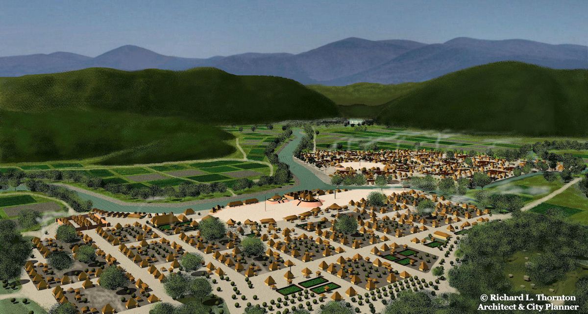
Let’s back track. When I was in college, we were taught that the American Indian tribes of the Southeast were pretty much the same as the federally recognized tribes today and that they had lived in the same locations for thousands of years. Distinct periods of architectural and pottery styles were called “phases,” because of the orthodoxy that the same people had lived in the same place. Furthermore, the ancestors of the Creeks, Choctaws, Chickasaws and Alabama were not “civilized” even though they were consummate farmers and had large towns as capitals. It was said that they lived in chiefdoms without formal governments that were temporarily controlled by “big men.” These chiefdoms rarely lasted longer than the “big man’s” life.
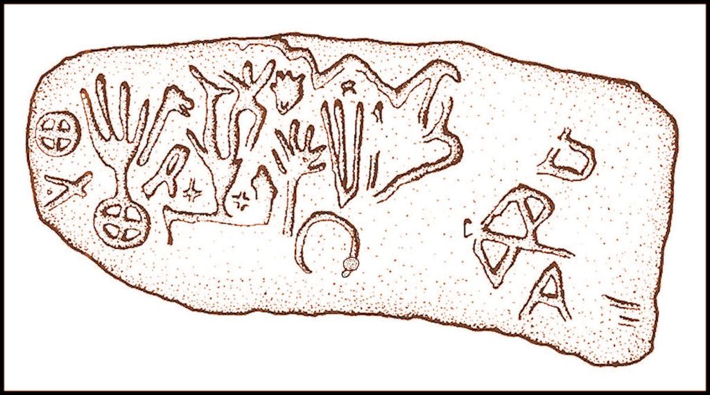
Even though Governor James Edward Oglethorpe described the Creeks “as the descendants of a great civilization” in a letter to King George II, contemporary anthropologists refused to label them civilized because they didn’t have a writing system. Wikipedia states that the Cherokee syllabary was the first indigenous writing system north of Mexico. YET, it was also Oglethorpe who sent to King George II an example of the Creek writing system, which was capable of transmitting long histories and complex statements. When I found the original colonial documents, describing this writing system in 2015, academicians ignored the information and continue to replicate an inaccurate orthodoxy.
The only form of trade in this dumbed-down description of the past was “the exchange of prestige goods” between neighboring “big men” who dominated the chiefdoms. We were taught that these chiefdoms only had primitive sustenance economies, where only enough food was grown and items crafted to meet their current needs.
What eyewitnesses actually said
The conquistadors of the De Soto and Pardo Expeditions in the mid-1500s, were not particularly interested in ethnology, but they were interested in economics. Their chroniclers told us that the people of Chiaha [1540] in present day western North Carolina cultivated vast fields of salvia, plus honey bees, who pollinated the salvia. Both the salvia seeds and honey were exported.
I always get amused by the propaganda that was put out by the Georgia Council of Professional Archaeologists and Society for Georgia Archaeology in 2012. They told us that there was no linguistic evidence of the Mayas ever immigrating to North America. The Itza Maya word for salvia is chia . . . for river is haw. Chiaha means “Salvia River.” The Itza homeland was in Chiapas, Mexico, whose name means “Salvia – Place of.”
- De Soto’s chroniclers told us that Coça (Kusa, Coosa) cultivated vast orchards of hickory trees from which hickory nut oil and butter were made [1540]. The people of Kusa had grown wealthy from the exportation of hickory nut oil and butter.
- A member of the garrison at Fort Caroline wrote home in 1564 that the Alecmanni, who lived upstream from the French about 21 miles, specialized in the cultivation of medicinal plants. Their name meant “medicine or doctor- people.” After the Spanish invaded their homeland, the Alecmanni moved upstream to Northeast Georgia. In particular, they had grown wealthy from the exportation of cinchona bark from which quinine was made. In 1776, botanist William Bartram found feral cinchona still growing along the edge of the Altamaha River in Georgia. Fort Caroline was obviously on the Altamaha River in Georgia, not in Florida.
Here is a bigger surprise, though. Alecmanni only means “Medicine or Doctor People” in one language, Angliska . . . Archaic English. The Angles originally lived in southern Sweden then later immigrated to southern Denmark before sailing across the North Sea to Britannia.
- René de Landonnière wrote [1564-1565] that the Apalache in northern Georgia had grown wealthy off the export trade of greenstone, gold, copper and mica throughout North America.
- The Satile at the mouths of the Altamaha and Satilla Rivers traded salt, sea shells, turtle shells, dyes made from mollusk shells and salt-dried fish to the Apalache to obtain these items and to the Okute mid-way to obtain white clay.
- The great town of Etula (Etowah) in Northwest Georgia exported ocher, indigo pigment, copper oxide pigment, mica, gold, aluminum oxide pigment, barium oxide pigment and manganese oxide pigment throughout eastern North America.
- Provinces in areas well suited for growing Indian corn, beans or squash grew a surplus of crops to use as trade to obtain special raw materials from the mountains and seacoast. Provinces along the Altamaha and Savannah Rivers took a share of the bulk trade items as a tariff on goods passing through their territories.
- The Itza Mayas operated very sophisticated salt extraction facilities on Taube (Tybee) Island near Savannah. Taube is the Itza and Creek word for salt. The salt was distributed throughout the Southeast by Uchee traders, based nearby on the Ogeechee River.
- Panoans from Peru cultivated vast orchards of yaupon holly on Asebo (Ossabaw) Island and exported the dried leaves to much of Southeastern North America. Ase is the Panoan and Creek word for both yaupon holly and the tea made from those leaves.
- Southern Arawaks from Peru grew yaupon holly on Aseo (St. Simons) Island and exported the dried leaves up the Altamaha River.
- Tupi towns, located on estuaries south of the Ogeechee River grew a sweet variety of tobacco called petun and exported it throughout much of North America. The Tupi were originally from Suriname and the coastal areas of Brazil.
- Juan de la Bandera, chronicler of the Juan Pardo Expeditions, wrote that there was a town in present-day South Carolina, which specialized in the cultivation and exportation of sweet potatoes. It was called Aho, which is the Lower Arawak [Peru] and Creek word for sweet potato.
Constitutional monarchies
The published writings of several eyewitness authorities in the Creek Homeland . . . from Charles de Rochefort to James Edward Oglethorpe to Thomas Christie to William Bartram . . . clearly do not describe unstable “chiefdoms,” dominated by a “big man.” De Rochefort [1658] stated that the Apalache Kingdom was founded by a very sophisticated elite, whose ancestors came from Peru and Mexico.
The Apalache elite lived in separate villages from the commoners. In the Nacoochee Valley, the elite village is about 1/4th mile from the Itzate village, where the Nacoochee Mound is located. One mile up the river was Cho’ite – another Maya tribe from southern Mexico. Two miles to the east was a large Sokee or Saute town, yet another Maya tribe from southern Mexico. De Rochefort stated that many distinct ethnic groups made up the tribal members of the Apalache Kingdom, which actually functioned as a confederacy with a constitutional monarch.
Within the noble families of the Apalache and member tribes were judges, land surveyors, architects, historians, priests, astronomers, time keepers, construction foremen, fulltime soldiers and artisans, whose livelihoods were supported by commoners, whose main responsibilities were farming, hunting and fishing. That is NOT the description of a primitive chiefdom.
Within the Apalache elite was a royal family named the Paracuste. Paracus is the actual name of the tall, super-brainy “egg heads” of the Nazca Plain in Peru, who left Peru around 200 BC. Apalache itself is a Panoan word from Peru. From this royal family was elected a leader, who functioned like a CEO and who could be deposed by the vote of the elite families.
The Apalache “king” had no more power than a US president. Major decisions such was declarations of war, approval of peace treaties, acceptance of immigrants and construction of new towns could only be executed with the consensus approval of an Upper Level Council (House of Warriors) and a Lower Level legislative body containing representatives of all the member tribes and their clan mothers. This is exactly the political structure of the Creek Confederacy, described by James Oglethorpe and Thomas Christie in 1735.

Pairing of towns
There was a peculiar custom in the Creek Homeland that can’t quite be explained, but was specifically mentioned in the Creek Migration Legend and by several eyewitnesses in the Colonial Period, plus has been confirmed over and over again by archaeological investigations. Two distinct ethnic groups would build their towns beside each other or across the river from each other.
The Creek Migration Legend says that this was common among the Chickasaw and Kaushete. Late 20th century archeologists in Tennessee called these pairings the Mouse Creek and Dallas Phases. LOL Unfortunately, some University of Tennessee anthropology professors didn’t do their homework and labeled the Chickasaw architecture as being Uchee.
- Along the Upper Savannah, Upper Ocmulgee and Middle Chattahoochee Rivers, Coweta-Creek and Kaushete-Creek towns were paired.
- Along the Upper Chattahoochee River in the Nacoochee Valley, Itsate-Creek and Apalache-Creek villages were paired.
- Along the Oconee River in Georgia and the Oconaluftee River in western North Carolina, fortified Itza towns were paired with dispersed Uchee villages and farmsteads.
- On the upper Little Tennessee River, the Tuskegee and Talassee Creeks were satellite villages of the Chiaha towns.
- On the lower Little Tennessee River in Tennessee, Itsate and Kaushete villages were paired with a large Koasati town.
- On the Hiwassee River and on Hiwassee Island, Tennessee, Mesoamerican style Tanasi and Kaushete towns were paired with round Uchee towns.
- On the Harpeth River in north central Tennessee at Mound Bottom, are two large towns across the river from each other. Although Wikipedia states that the town with the larger mounds was founded by people from Cahokia around 950 AD, I have looked at the archaeological report. That is impossible. The mounds and houses at Mound Bottom are identical to those at the acropolis of Ocmulgee National Historical Park. In 950 AD, Cahokia may have not contained any mounds and was merely a large village. Cahokia never had the large rectangular houses that typified Ocmulgee. More likely is that the town with larger mounds were Itza elite from Ocmulgee and the Pack Site across the river was occupied by the Chickasaw.
- On the Coosawattee River, an Apalache-Creek elite lived in a town name Kaushe (Coça). On the north side of the river, were located Chickasaw villages. On the south side of the river were Commoners villages, occupied by the Kansa or Kaw People. They later moved to Kansas. However, even today, there are several key Chickasaw words in their language. Their traditional clothing is straight from the Apalache-Creeks.
- On the Tallapoosa River, Tallapoosa-Creek villages were paired with dispersed Kansa farmsteads. One of those farmstead was excavated in the 1990s on the Dog River in Douglas County, GA.

An example of a multi-ethnic landscape
Below is a map from the Native American Encyclopedia of Georgia. It denotes the many ethnic groups that were on the coast of Georgia and South Carolina. They were from all over the Americas, Ireland and even southern Scandinavia!


Particularly interesting about the pre-Columbian trading networks, as well as the paired towns.
In case you haven’t already seen this video of a Georgia mound reputed to be Native American by local oral history:
LikeLiked by 1 person
I don’t understand why they paired ethnic group towns, but there must have been a very practical reason. Perhaps intermarriage prevented birth defects.
LikeLiked by 1 person
I believe that it is a mound. It may not be a burial mound, but rather a ceremonial mound.
LikeLiked by 1 person
The paired towns do suggest some sort of alliance don’t they. Perhaps protection or conquering, similarly to the “Tutelos”, originally from VA and the Carolinas, who became tributaries of the Iroquois/Hodenosaunee and later national confederates. (A Tutelo park was created here in Ithaca a few years ago.) Perhaps another possibility for the paired towns is simply mutual trade.
That Georgia mound looked likely to be human-made to me too. And it looks pretty big!
LikeLiked by 1 person
Thank you so much for the map!!!
LikeLiked by 1 person
You are quite welcome.
LikeLike