by Richard L. Thornton, Architect & City Planner
Estado de Chiapas – Latitude: 17° 29′ 3″ N Longitude: 92° 2′ 47″ W
One Summer In Mexico – Part 50

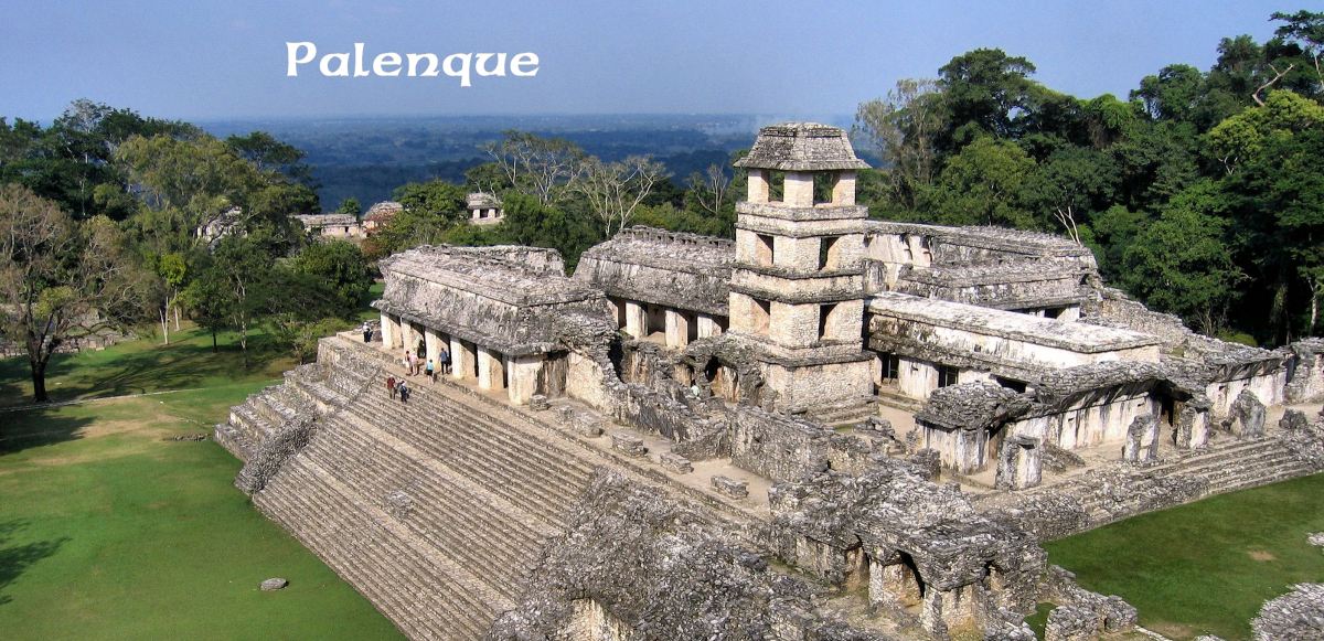
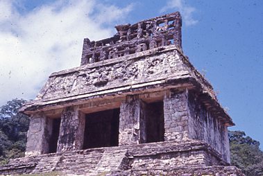
Palenque was a Late Pre-Classic and Classic Period Maya city on the edge of the Sierra Oriental Mountains in central Chiapas State. It is within the Usumacinta River Basin. The terrain in and around the city is quite mountainous, although its actual elevation above sea level is modest. (See next paragraph.)
The city was definitely occupied from c. 226 BC to c. 800 AD. It sits on an escarpment, overlooking the Chiapas and Tabasco Lowlands at an elevation of 150 meters (490 ft) above sea level. Its average temperature is 26 °C (79 °F) with precipitation of roughly 216 cm (85 in) rain a year.
Currently, the excavated area of Palenque includes up to 2.5 km2 (1 sq mi), but Mexican anthropologists estimate that less than 10% of the total area of the city is explored, leaving more than a thousand structures still covered by jungle. Thus, there is much still unknown about the city’s cultural traits and architecture.
Etymology: Palenque is a Spanish word, meaning “palisade.” This may refer a Spanish or indigenous fort on the site during the Spanish Contact Period. Since no one could read Maya writing when I visited Palenque in 1970, no one knew its real name. Today, we know that its indigenous name was Lakamha, meaning “Big Lake” in the local Maya dialect. Its Yucatec Maya name was Bàakal.
Palenque was one of the most elegant and architecturally unique cities in the Maya world, although in size it was in the mid-range of population. What Mexicans call the Rio Otulúm flows through the city. It is really a shallow mountain creek. Unlike most Maya cities, there is very little level agricultural land near Palenque. It was totally dependent on mountainside terraces for its food supply.

History of Palenque
I cannot emphasize enough that nothing was known about the history of Palenque, when I visited it, not even its age. I merely analyzed its architecture and art as they appeared at that time. Everything in this section of the article was learned between around 1988, when Linda Schele, David Stuart and their associates began, glyph by glyph, translating its engraved writing, and the most recent excavations in 2019.
It is now known that a village may have existed at the Palenque site as early as 2525 BC. Certainly, a town was there by 250 BC. An army from Teotihuacan conquered most of Chiapas around 200 AD. Princes from Teotihuacan were placed as kings for Palenque until around 550 AD. A significant amount of public writing did not occur until around 400 AD. Kʼukʼ Bahlam I, also known as Kuk and Bahlum Kʼukʼ, (March 30, 397 – 435?), was a founder and ahaw of the ruling dynasty at the Maya city of Palenque. He founded the dynasty on March 10, 431.
When Ahkal Mo’ Naab I died in 524, there was an interregnum of four years, before the following king was crowned at Toktán in 529. K’an Joy Chitam I governed for 36 years. Palenque was seriously damaged by an eruption of the El Chichon Volcano in 540 AD. Chitam’s sons Ahkal Mo’ Naab II and K’an B’alam I were the first kings who used the title Kinich, which means “the great sun”. This word was used also by later kings. Economic and population stagnation continued after the eruption until around 600 AD.
B’alam was succeeded in 583 by Yohl Ik’nal, who was supposedly his daughter. The inscriptions found in Palenque document a battle that occurred under her government in which troops from Calakmul invaded and sacked Palenque, a military feat without known precedents. These events took place in 599.
A second victory by Calakmul occurred some twelve years later, in 611, under the government of Aj Ne’ Yohl Mat, son of Yohl Iknal. In this occasion, the king of Calakmul entered Palenque in person, consolidating a significant military disaster, which was followed by an epoch of political disorder. Aj Ne’ Yohl Mat died in 612.
B’aakal began the Late Classic period in the throes of the disorder created by the defeats before Calakmul. The glyphic panels at the Temple of Inscriptions, which records the events at this time, relates that some fundamental annual religious ceremonies were not performed in 613, and at this point states: “Lost is the divine lady, lost is the king.” Mentions of the government at the time have not been found.
It is believed that after the death of Aj Ne’ Yohl Mat, Janaab Pakal, also called Pakal I, took power thanks to a political agreement. Janaab Pakal assumed the functions of the ajaw (king) but never was crowned. He was succeeded in 612 by his daughter, the queen Sak K’uk’, who governed for only three years until her son was old enough to rule. It is considered that the dynasty was reestablished from then on, so B’aakal retook the path of glory and splendor.
The grandson of Janaab Pakal is the most famous of the Mayan kings, K’inich Janaab’ Pakal, also known as Pakal the Great. He began rule at the age of 12 years after his mother Sak Kuk resigned as queen after three years, thus passing power on to him. Pakal the Great reigned in Palenque from 615 to 683, and his mother remained an important force for the first 25 years of his rule. She may have ruled jointly with him. Known as the favorite of the gods, he carried Palenque to new levels of splendor, in spite of having come to power when the city was at a low point. Pakal married the princess of Oktán, Lady Tzakbu Ajaw (also known as Ahpo-Hel) in 624 and had at least three children.
Most of the palaces and temples of Palenque were constructed during his government; the city flourished as never before, eclipsing Tikal. The central complex, known as The Palace, was enlarged and remodeled on various occasions, notably in the years 654, 661, and 668. In this structure, is a text describing how in that epoch Palenque was newly allied with Tikal, and also with Yaxchilan, and that they were able to capture the six enemy kings of the alliance. Not much more had been translated from the text.
After the death of Pakal in 683, his older son K’inich Kan B’alam assumed the kingship of B’aakal, who in turn was succeeded in 702 by his brother K’inich K’an Joy Chitam II. The first continued the architectural and sculptural works that were begun by his father, as well as finishing the construction of the famous tomb of Pakal. Pakal’s sarcophagus, built for a very tall man, held the richest collection of jade seen in a Mayan tomb. A jade mosaic mask was placed over his face, and a suit made of jade adorned his body, with each piece hand-carved and held together by gold wire.[1]
Furthermore, K’inich Kan B’alam I began ambitious projects, including the Group of the Crosses. Thanks to numerous works begun during his government, now we have portraits of this king, found in various sculptures. His brother succeeded him continuing with the same enthusiasm of construction and art, reconstructing and enlarging the north side of the Palace. Thanks to the reign of these three kings, B’aakal had a century of growing and splendor.
In 711, Palenque was sacked by the army of Toniná, and the old king K’inich K’an Joy Chitam II was taken prisoner. It is not known what the final fate of the king was, and it is presumed that he was executed in Toniná. For 10 years there was no king. Finally, K’inich Ahkal Mo’ Nab’ III was crowned in 722. Although the new king belonged to the royalty, there is no evidence that he was the direct inheritor direct of K’inich K’an Joy Chitam II. It is believed, therefore, that this coronation was a break in the dynastic line, and probably K’inich Ahkal Nab’ arrived to power after years of maneuvering and forging political alliances. This king, his son, and grandson governed until the end of the 8th century. Little is known about this period, except that, among other events, the war with Toniná continued, where there are hieroglyphics that record a new defeat of Palenque.
Occasionally city-state lords were women. Lady Sak Kuk ruled at Palenque for at least three years starting in 612 CE, before she passed her title to her son. However, these female rulers were accorded male attributes. Thus, these women became more masculine as they assumed roles that were typically male roles.
Abandonment: During the 8th century, B’aakal came under increasing stress, in concert with most other Classic Mayan city-states, and there was no new elite construction in the ceremonial center sometime after 800. An agricultural population continued to live here for a few generations, then the site was abandoned and was slowly grown over by the forest. The district was very sparsely populated when the Spanish first arrived in the 1520s.
Palenque, when I was on the 1970 fellowship
Not only did I purchase a new, more sophisticated camera from money sent me by relatives for my birthday in early August 1970, but the color slides that I took in the lands of the Mayas, Zoque, Itza and Totonacs during mid-August and early September 1970 are almost in perfect condition in 2020. The film cartridges were not developed until I got back to Atlanta. Apparently, the Kodak lab in Atlanta used a process that produced a color slide far less sensitive to heat and humidity than those processed in Mexico City. There is almost a thousand of them. They can only be appreciated in the format of a video.
So, my images of the Maya cities will be primarily presented in a series of documentaries on the People of One Fire YouTube Channel. In these videos, I will analyze the architecture of individual buildings and expanses of carved bas reliefs.
My architecture and archaeology textbooks, utilized in the fellowship, are almost useless today, when discussing southern Mexico and the Maya Civilization. In fact, all contain assumptions that seem hilarious today. The anthropology profession badly misinterpreted the Maya Civilization, prior to having liberal access to the Spanish colonial archives, radiocarbon dating, infrared photos, Lidar scans and the ability to read the Maya writing system.
First impressions of Palenque
Almost the moment I set foot on the landscape of the Highland Maya city of Palenque, I became enchanted by the place. Dr. Piña-Chan’s revised syllabus had allotted me one day of travel from Villahermosa through the States of Tabasco and Chiapas to Palenque . . . only one day in Palenque . . . then one day bus travel in a northwestward direction to La Venta in northern Tabasco.
I still had a couple hundred dollars (about $800 today) left in the fellowship, so I stayed an extra day in Palenque then traveled to the Tonina archaeological zone in another part of the Chiapas Highlands before heading to La Venta. This, though, required me to fly back to Atlanta two days before I was to register for Fall Quarter at Georgia Tech.

One thing that I did on the second day that apparently most archaeologists have not done is follow the Rio Otulúm to its source. One can wade up the stream with rubber sandals. The vegetation is gorgeous. I also saw many colorful birds. In the stream are large purple-to-burgundy colored snail shells. They are the “cigar shape” type of shells and make wonderful necklaces as gifts. I picked up a two-gallon plastic bag of them. I still have some in my possession.
At the source of the Rio Otulúm is a cave, surrounded by small temple buildings. The architectural style of most of the buildings seems to date from the early days of Palenque. As far as I know, archaeologists have never studied this complex. Probably, few know that it exists.
If I had known then what I know now, I would have spent two weeks in Chiapas and the interior of Tabasco. In earlier articles, you read how the majority of peoples, who later made up the Creek Confederacy, originated in southern Veracruz, Tabasco and Chiapas. However, you will learn in this article that there is an extraordinary, irrefutable cultural connection between the region around Palenque and the advanced indigenous cultures of the Southeastern United States.

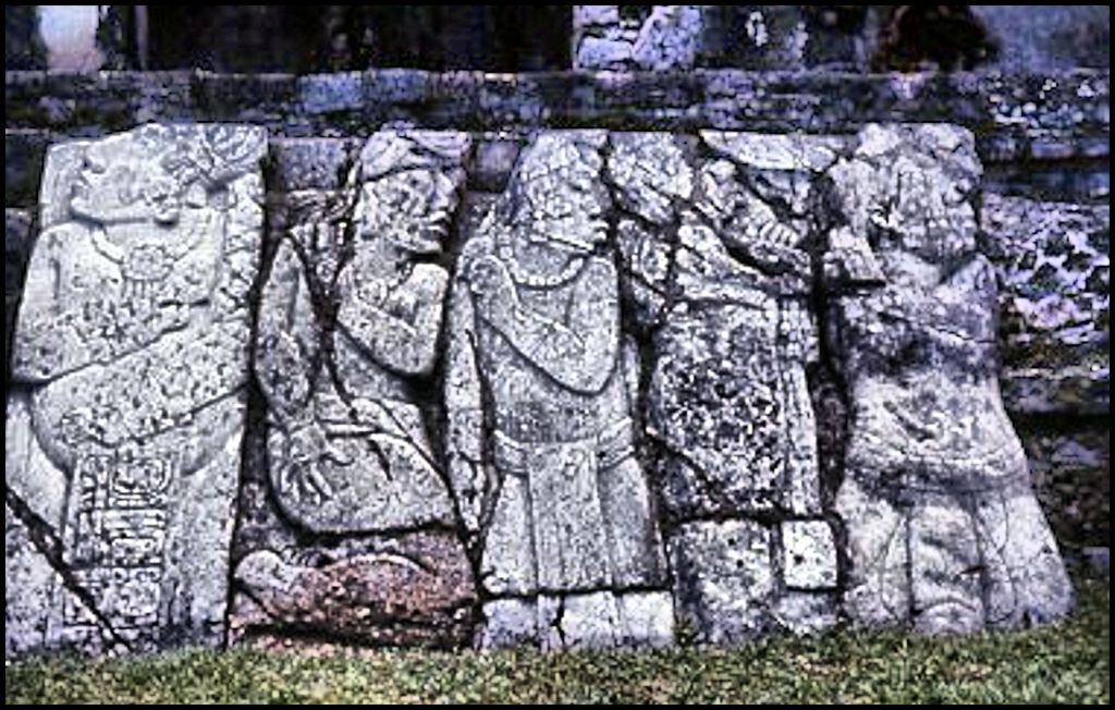
For those of you, who have not read previous Americas Revealed articles, while at Palenque, I toured and photographed the ruins with David and Linda Schele from Mobile, Alabama. I also joined up with them at some other Maya sites. We ran into George Stuart in the courtyard of the Palace at Palenque, where he was photographing some stone bas relief panels. Picking up our southern accents, George modestly described himself as “an archaeologist from South Carolina.” Well, yes . . . and also destined to be Chief Archaeologist, Director of Photography and then Executive Director of the National Geographical Society. It was George’s articles and photographs of ancient Maya cities that electrified the world in the 1960s and 1970s.
This was an era when all non-African-American Southerners were subject to frequent verbal abuse from tourists originating north of the Mason-Dixon line, no matter what their education or social attitudes were. It was especially ludicrous in my case, since I was a Creek – the only people, who gave sanctuary to escaped slaves – and one of my ministers at our Methodist congregation on the Georgia Tech campus was the Rev. Andrew Young, who was standing beside the Rev. Martin Luther King, when he was murdered.
For example, I had been graduated from Georgia Tech 36 hours, when riding the ferry from Copenhagen to Landskrona, Sweden. At the prow of the ship, I happened upon two young ladies from Minnesota, who had just graduated with degrees in Education from the University of Minnesota. Virtually, the first thing they said to me was, “We always wondered what it would be like to come out of a backward educational system.” Shortly after returning from working in Sweden and traveling three months in Europe, I took the Graduate Entrance Exam (GRE). I scored in the upper 5% percentile of all college graduates, who took the exam. Guess my education was not that backward after all. LOL
Meanwhile, tourists from the United States had a very bad reputation in other nations, because of their combined arrogance and ignorance. Numerous times in Mexico, locals noticed that I treated them with respect. As a compliment, they would say that I was a Gringo, not a Yanqui. Both when traveling in Mesoamerica and in Europe, I always buddied up with Europeans, fellow southerners, Californians, Canadians, Australians, New Zealanders and in Spain, three white girls from Kenya. Californian tourists, my age, were consistently very non-judgmental with people they encountered.
This strategy had a two-fold purpose. First, I avoided the slander, arrogance and stupidity exhibited by many American tourists and secondly, I avoided the automatic hostility toward Americans, exhibited by many foreigners . . . particularly in Europe.
As a teenager, I taped several of George Stuart’s photographs of Maya cities on my bedroom wall. It seemed to be an impossible dream that I would ever actually see these seemingly faraway places in person. In the early 1980s, George came to my farm in the Reems Creek Valley, north of Asheville, NC to photograph it for a book on the Appalachian Mountains. Even though we spent hours in my house, talking about Mesoamerican civilizations, George still did not reveal that he was the author of those famous articles on the Mayas . . . that he was a professional archaeologist and had worked one summer at the Etowah Mounds dig. By then, he was Director of Photography for National Geo and that was the only professional title he used.
David’s photo of me is the only surviving image of me in the Maya country. I held Linda as she leaned over to photograph the sarcophagus. We didn’t know his name at the time. David was an architecture professor on a grant to photograph Maya ruins. Linda was an art student. Linda was so impressed by Palenque that she switched to anthropology and focused her postgraduate research on Palenque.
1982, just twelve years later, Linda published, Maya Glyphs: the Verbs. It was the first book to “crack” the Maya writing system code. Linda’s research was done in conjunction with Dr. David Stuart, George’s son, who began solving the Maya writing system as a youth, while watching his parents excavate sites at Palenque.
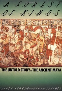
In 1990, Linda Schele and David Freidel published one of the most important archaeological books of all time . . . A Forest of Kings. With the help of David Stuart, they had translated most of the Maya inscriptions at Palenque and many other important Maya cities. Suddenly, the Mayas had detailed, written history, which radically changed our understanding of their civilization. Suddenly, we knew who was buried in the sarcophagus. It was the founder of Palenque, Great Sun (High King) Pacal. We also knew the names of all the kings and queens of Palenque up to 800 AD, when the town was incinerated by a super-volcano. Carved monuments at Palenque revealed that earlier there was a “Maya Dark Ages” between 539 AD and 600 AD.
The word, Maya
For starters, the Mayas did not call themselves the Mayas . . . at least during the period of Classical “Maya” civilization. Each city state or tribe in the case of less developed regions, considered themselves a separate ethnic group. There was an advanced tribe named the Mia . . . with an M pronounced almost like an English “Ma.” It was based in the region around Lake Okeechobee, Florida, but also settled in the tip of the Yucatan Peninsula in the period around 900-1000 AD. Mia means “lake” in both their language and in the Creek languages.
Miami in Chontal Maya, Florida Maya, Itza Maya and Creek means “Lake (People) – Principal.”
The word, Maya, comes from a brother of Cristobal Colon, whose ship encountered a large sea-going canoe off the northern tip of Yucatan. At that time, a long Ī sound was written in Castilian as a “y.” When the occupants told the Spaniards that they came from Miam (Mia-Place of) it was recorded as Mayam – correctly pronounced in English as Ma-I-am. Eventually, Spanish authorities labeled all tribes in that part of Mesoamerica, Maya (Maia).
What caused the abandonment of many “Maya” cities?
We were taught that the Mayas were a non-violent people, led by ascetic priest-astronomers, who spent their days discerning the truths of the universe. It was commonly believed that the majority of cities suddenly disappeared around 1000 AD due to a plague. It is now known that Palenque and a substantial portion of the Chiapas Highlands were incinerated by the explosion of a super-volcano in 800 AD. The abandonment of the agriculturally rich, Chiapas Highlands triggered food shortages, which triggered wars, which evolved into apocalyptic self-destruction after a long drought starved the central and southern sections of the Maya realm.
However, we also know that the cities in northern Yucatan were not seriously affected by the drought. Many Itzas fled to northern Yucatan. Others fled to what is now the Southeastern United States. Chichen Itza contains bas relief panels that describe visits to their city by Itza dignitaries from Georgia and Florida. Some of the Maya cities in the north, continued to thrive until the arrival of the Spanish in the early 1500s.
We also know that Chichen Itza was captured around 1000 AD by invaders from Mexico. Much of its Itza population fled. The date of 1000 AD corresponds to the appearance of “corner door” houses, typical of Chichen Itza in Georgia and a little later in Tennessee. There was another influx of Itza and Kekchi Maya architecture in Georgia 1250 AD. Along with the ancestors of the Creeks, the Itza and Kekchi were the only peoples in America, who repeatedly constructed five-sided earthen mounds.
As for Palenque, an astonishing discovery was made by scientists at the University of Minnesota in October 2012. There was a 100% match between attapulgite from a mine near the Chattahoochee River in Georgia and the Maya Blue stucco at Palenque! There is very little attapulgite in Mexico. I strongly suspect that the red and blue stuccos at Teotihuacan were also made from Georgia attapulgite. I also am almost certain that the vast quantities of mica used in Maya stucco, murals and cosmetics came from Georgia. Right now, archaeologists state that the Chontal Maya merchants sailed around 4,000 miles to an area of Brazil to obtain mica, but have no scientific proof of it. That is ludicrous, when it would be so much easier to paddle down the Chattahoochee River to the Gulf of Mexico then follow the coastline of Florida then hop to Cuba then hop to Yucatan.

Chontal Mayas
Even the knowledge that the Chontal Maya mariners existed is really a product of 21st century research . . . and NOT by professional anthropologists. Dr. Piña Chan never mentioned the Chontal Mayas in my revised research syllabus or personally, at the chat sessions, we had in his office at the Museo Nacional de Antropologia. They were minimally mentioned within the exhibits at the archaeological museum in Villahermosa, Tabasco, but nothing was said of their boat-building or nautical skills. For that information, we can primarily thank Floridian, Douglas Peck. He died at the age of 95 on February 15, 2014.
Peck, who was an enthusiastic sailor, became intrigued with the accounts of large plank-built boats, seen by early Spanish explorers in the Gulf of Mexico and Caribbean Basin. Unlike many of generations of academicians before him, he went to the trouble to systematically go through the Spanish Colonial archives in Mexico to figure out exactly who the Chontal Mayas were. By 2005, his research had convinced professional archaeologists in Florida that the Chontal Mayas constructed sea-going, sail-driven vessels, very similar in construction and size to Scandinavian lång båts (longboats). The Chontal boats were capable of hauling people or cargo anywhere in the Americas. They probably could have crossed the Atlantic, but Peck found no evidence of that.
The Chontal Maya were immigrants from Central America, probably Nicaragua. The originally spoke an entirely different language than the Maya language family, but over time began speaking a dialect of Itza. Itza itself was a mixture of a Panoan language (South America), Kekchi Maya and Totonac. Being allies of the Itza, it is almost certain that the Chontal conveyed Itza traders and refugees to the Southeastern United States.
Peck discovered something else interesting. The Mayas in northern Yucatan constructed plank-built canoes with exaggerated, curved bows and sterns. The Native Americans of southern Florida and the Georgia coast built identical canoes, but they were carved out of wood. It is quite common to find Chontal-type canoes and boats portrayed in Creek art, even though the Creeks primarily constructed square-ended, dug-out canoes.
Peck’s research was published several times in Florida-based archaeological and historical publications, but never received national attention, other than being posted on the web, during the early days of the internet. In the years since then, I have tried to make his discoveries known to the world.

The Yaupon Holly smoking gun
The Creek Sacred Black Drink is made from the roasted leaves of the Yaupon Holly (ilex vomitoria). The loathsome botanical name, vomitoria, comes from the mistaken belief by European botanists that it caused one to vomit. Until the American Revolution, large quantities of Yaupon leaves were grown commercially along the coast of Georgia, South Carolina and North Carolina then exported to Great Britain. Yaupon Tea was in direct competition with Indian Tea. The Asian tea plant is also a member of the Holly family. Being much closer to Europe, Yaupon Tea would have probably won the battle, had not the Revolution drastically reduced trade between the former North American colonies and England.
Actually, Yaupon Tea is the virtually the same tasty caffeinated beverage that is called maté by Latin Americans and asē by Native Americans in Peru, Ecuador and the western Amazon Basin. The Creek languages also call this beverage, asē.
What does that tell you? Southeastern anthropologists (like many other things) are totally oblivious to this linguistic connection. In the United States, wild yaupon only grows naturally in the coastal plains near the Atlantic Ocean and Gulf of Mexico. At the time of European contact, yaupon was cultivated at an industrial scale on two islands along the coast of Georgia, Asebo (Ossabaw) and Aseo (St. Simons). Asebo is the Panoan (Peru) word meaning “Yaupon Holly- Place of.” Aseo is the Southern Arawak (Peru, Ecuador, Brazil) word meaning “Yaupon Holly-Principal Place.” I strongly suspect that North American Yaupon Holly is a cultivated variant of the very similar plant by the same Native American name, which grows in the foothills of the eastern Andes Mountains and in the Upper Amazon Basin.
There is one other place where Yaupon Holly plants now grow naturally in the wild. It is in the vicinity of Palenque, Chiapas. Local Soque and Itza Mayas gather the Yaupon leaves and make their own “Sacred Black Drink” from them.
The impact from outer space
In 2009, Dallas Abbot of Columbia University found nodules associated with a major asteroid or comet strike at the “500s AD level” of the Greenland Ice Shelf. She insisted that either a comet or asteroid played a role in the climatic catastrophe. She examined the coast line of Florida and Georgia, finding proof that the impact occurred off the coast of Cape Canaveral, Florida – permanently wiping out the coastal islands of Florida, but also creating a tsunami ridge on the Georgia coast up to 85 feet in height today . . . so the tsunami was probably about 150 feet tall or more.
The explosive heat wave from this impact probable incinerated forests and killed humans over a vast area of Florida, Georgia and South Carolina. Archaeologists have long been puzzled why all the Proto-Creek Swift Creek villages below the Fault Line in Georgia were suddenly uninhabited around 550 AD, while those in the Piedmont suddenly went into step decline in population. Now we know!
In 2010 a Greek archaeologist, Dr. Amand Laoupi, reinforced Abbot’s theories by revealing a second ammonia spike in the Arctic ice shelf in 539 AD. The spike was clearly unrelated to volcanic activity.

Palenque twice devastated by volcanic eruptions
The youngest known calendar date at Palenque was carved in the year 799 AD. However, all texts still dated the abandonment of the city to be similar to other major cities in the Maya Heartland or around 900 AD. They also assumed that Palenque was abandoned for the same reasons as the other cities.
In 2008, while excavating a ruin at Palenque, archaeologists, employed by the Instituto Nacional de Antropologia E Historia de México (INAH) discovered a layer of volcanic ash inside the ruin. It was closely in association with charred structural timbers. The charcoal was radiocarbon dated to approximately 800 AD. Prior to that time, the youngest known dates for charcoal at Palenque were also around 800 AD. However, prior to 2008, archaeologists had quickly swept aside layers of volcanic ash, while excavating buildings.
Soil samples were taken in many other areas of the Chiapas Highlands. There they also found a deep ash later, dated to around 800 AD. The geologists and archaeologists soon realized that Palenque had been incinerated by the El Chichon Super-volcano at that time. The eruption was so massive that it would have caused widespread deaths in the region and a general abandonment of Chiapas for at least a generation or more. The surviving Itzas and Soques were forced to migrate elsewhere in order to survive. There was no general explanation of where they immigrated.
In 2017, geologists discovered another deeper layer of ash throughout the Maya world, which was dated to about 540 AD. This eruption was not as intense at Palenque and probably did not include a killer cloud of super-heated air, but it would have severe impact on agriculture. It occurred only about a year or less have the catastrophic impact of an extraterrestrial impact off Cape Canaveral, Florida. A vast area of Mesoamerica and eastern North America was either depopulated or suffered population decline for about 50 years.
Architectural research
Throughout the years following 1970, I never gave much thought to the question of Maya immigration into eastern North America until the last few months of 2011 and in 2012. It did not seem to be associated with architectural search. However, with a little research and thought put on the subject, architecture became some of the strongest evidence of cultural ties between the ancestors of the Creek Indians and southern Mexico.
North American, European and Mexican architects in the mid-1800s were the first professionals to study the ruins of Maya cities. They immediately noticed the strong cultural connections between the so-called Southeastern Moundbuilders and Mesoamerica. This is something that most North American archeologists still stubbornly resist. Architects knew that most of the stone veneered pyramids in Mexico began as earthen platforms and pyramids. Some cultures in Mexico only built earthen mounds . . . quite identical to those in the Southeastern United States. There were also strong similarities between the arrangements of structures and plazas.
Neither in Mesoamerica or North America are archaeologists particularly interested in agricultural terraces. They are either unaware or indifferent to vast acreages of terraces adjacent to certain Mesoamerican cities such as Teotihuacan, Monte Alban, Palenque and Bonampak. Thus, when I pointed out in the National Examiner that the Track Rock Terrace Complex was identical in composition to several agricultural terrace complexes that I photographed in the Chiapas and Guatemala Highlands, Georgia archaeologists first raged, “How dare you talk about archaeological sites!” then switched to trying to prove that that Track Rock’s terraces were not terraces. Actually, all of the terrace complexes that I photographed in the Highlands were in active use, so they were examples of agricultural architecture.
Mica
Several forms of mica are endemic in the Southern Highlands of the United States. Mica is almost non-existent in the region, where the Maya Civilization developed. There are deposits of sheet mica in the vicinity of the Pocatepetl Volcano, but it is extremely difficult to transport bulk commodities from the Central Highlands of Mexico to the Yucatan Peninsula and Guatemala. The distance was about 600 to 1000 miles through rugged mountains and dense jungles.
Maya architects used vast quantities of crushed mica as reinforcement for lime stucco. Fiberglas fibers are used for the same purpose today. Mica was also used in mural and as a cosmetic. So where did the Mayas obtain these vast quantities of mica?
Perpetually blind to the relative closeness and ease of sailing between the mouth of the Chattahoochee-Apalachicola River and the tip of Yucatan, several archaeologists in the United States proposed that the Mayas paddled over 5,000 miles then hiked inland about 250 miles to reach mica deposits in Brazil. There have been no scientific studies to match Maya architectural mica with any particular geographical sources.
Attapulgite
Attapulgite is a form of diatomaceous earth with very special chemical properties. It bonds chemically with certain dyes such as indigo and red ochre. The resultant chemical, after drying, becomes almost impervious to the elements. There is still Maya blue stucco on some buildings at Palenque, even though the city was incinerated by the heat of a super-volcano in 800 AD.
There are some small deposits of attapulgite in some cenotes in northern Yucatan. It is questionable if they were of significant size even to supply the needs of Maya cities, where they were located. In contrast, Georgia contains the largest deposits of attapulgite in the Americas and one of the largest in the world. They are located near the Chattahoochee and Flint Rivers, which are of sufficient depth to support large Maya freight canoes.
I postulated in my book, The Itza Mayas in North America that the attapulgite used for making Maya Blue pigment in the Chiapas Highlands and Central Mexico came from Georgia or sources in nearby in the Florida Panhandle. Probably, much of the remaining attapulgite used in Maya cities came from this same region. In early October 2012, a laboratory at the University of Minnesota determined a 100% match between a sample of attapulgite from a single mine in Georgia with the Maya blue stucco on a single building in Palenque. A sample from any other mine in Georgia would probably been a slightly less than 100% match. Thus, the scientists were extremely fortunate in matching the right mine with the right building.
The conclusion is intuitively obvious. If Chontal Maya mariners traveled to the interior of the Southeastern United States for many centuries to obtain precious commodities, they obviously developed a knowledge of its geography. They were in an ideal situation to become traders, who brought Mesoamerican seeds and refugees to the region.

Howdy, When I grow up I want to write like you do. Your box of chocolates has no end.
On Wed, Nov 18, 2020 at 12:23 PM The Americas Revealed wrote:
> alekmountain posted: ” by Richard L. Thornton, Architect & City Planner > Estado de Chiapas – Latitude: 17° 29′ 3″ N Longitude: 92° 2′ 47″ W One > Summer In Mexico – Part 50 Site plan from my 1970 INAH “Guia de Palenque” > Palenque was a Late Pre-Classic and Classic” >
LikeLiked by 1 person
Who said I ever grew up? I still have a wonderment toward God’s Creation.
LikeLiked by 1 person