A forgotten Native American civilization converted the valley into an artificial landscape.
by Richard L. Thornton, Architect & City Planner
Theoretically, neither Southern Longleaf Pines nor Eastern Hemlocks should have been endemic in the Shenandoah Valley. It is too dry, too rocky, too hilly and too cold for the Longleaf Pines, but too dry for the Eastern Hemlocks. Yet, Southern Long Leaf Pines once once covered the hilly portions of this famous valley, while Eastern Hemlock trees covered the mountainsides.
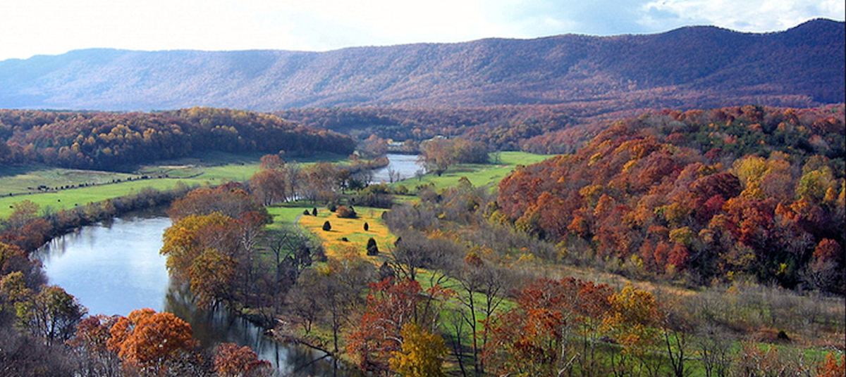
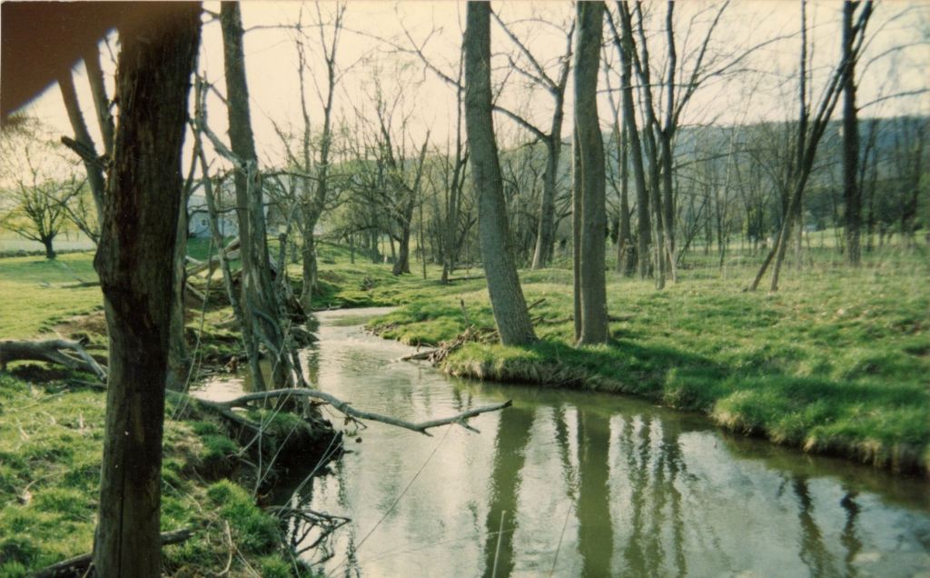
The 200 mile long Shenandoah Valley was created eons ago along a geological boundary between the Blue Ridge and Allegheny Mountains. The Blue Ridge Mountains contain volcanic rocks, while the Allegheny Mountains contain sedimentary and metamorphic rocks. It is a portion of the Great Appalachian Valley which runs from Quebec to east-central Alabama. The North and South Forks of the Shenandoah River begin in west central Virginia then flow northeastward to join near Front Royal, VA. They are separated by 50 mile long Massanutten Mountain, which is composed of very hard sandstone.
The climate of the Shenandoah Valley had changed radically in the past 30 years. The change began after the Great Perfect Storm of mid-March 1993, in which a winter hurricane barreled northward from the Gulf of Mexico. Instead of drawing heat from tropical waters, it drew super-chilled air from the Ionosphere. Our farm had 38″ of snow on the pastures and 15 feet drifts against the barns! Afterward, the region began receiving increasingly milder winters and less snow.

The bedrock underneath the North Fork Valley is dolomitic limestone (calcium magnesium carbonate) which makes the soil above especially fertile, especially for grazing animals. As of January 2021, there are 248 dairy farms in Rockingham County, VA alone, while the whole state of Georgia only contains 124 dairy farms. During the late 1980s and early 1990s, when I was living in the Shenandoah Valley, there were 330 dairy farms in Rockingham County.
There are primarily two types of soil in the Shenandoah Valley: colluvial and alluvial. Rolling hills make up most of the valley floor. They are covered by relatively thin layer of colluvial soil, which is composed of soil and organic particles washed down the slopes of the Allegheny Mountains over the eons, plus loess particles, which blew off the Ice Cap and foot of the ice cap during the last glacial epic plus volcanic particles from Icelandic and European volcanoes.
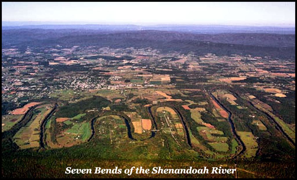
The second type of soil in the Valley is alluvial, which is the soil of the river and stream floodplains. Most of this type of extremely fertile, black top soil is located next to the Shenandoah River, but can also be found near smaller streams at certain locations. The Seven Bends Area produces corn yields per acre, comparable to those in Illinois or about 214 bushels per acre. Overall though, however, the Valley averages about 140 bushels per acre . . . which is good . . . but not comparable to the best soils in the Midwest.
Here is the problem, though . . . as the reader will soon learn, neither type of soil in the Shenandoah Valley is where Southeastern Longleaf Pine trees normally grows. First, we will tell you how I learned about this strange anomaly.
Unraveling the history of an old house
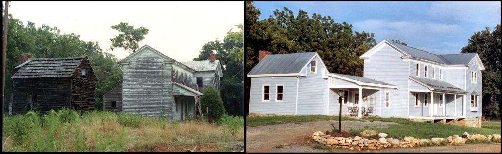
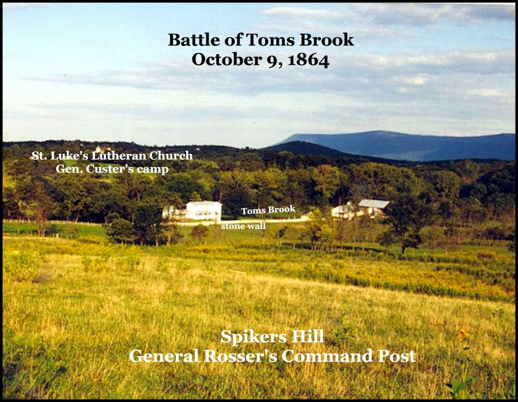
All I knew about the old house, when I bought the property in the late summer of 1987 was that it had been unoccupied since 1950 and was supposedly “an old Civil War house.” The last occupants had cooked in a fire place with pot cranes. There was no electrical service, plumbing, bathroom, kitchen or central HVAC system. Indeed, I would eventually learn that it was used as a hospital by the Confederates for much of the Civil War and stood at ground zero during one of the largest cavalry battles of the Civil War . . . the Battle of Toms Brook on October 9, 1864. It was designated as one of the key properties of the proposed Shenandoah Battlefields National Historical Park! The landscape of the farm was unchanged since that battle.
I soon learned that the original structure was a log and stone blockhouse, constructed under the supervision of Colonel George Washington in 1754. It was a location where local settlers could flee during raids by Indians, allied with the French. Such structures were scattered throughout the Valley, but nevertheless, the Valley’s population declined by 90% during the French and Indian War. A significant portion did not migrate out of the valley, but were either scalped or burned alive. Washington also carved his name on the big oak at the entrance to the present driveway of our farm. This particular blockhouse was named Tipton’s Fort.
All of the joists were logs that had been sawed down in 1754. Some of the log joists were 21 feet long under the floor of the Keeping Room and were perfectly level. John Tipton was an officer in the Virginia Militia and owned the land around the blockhouse. His neighbor across Toms Brook was the famous John Sevier, but Sevier later moved to the southern end of Dunmore (later Shenandoah) County.

During the opening years of the French and Indian War, , the block house was expanded into a log home for Tipton’s growing family. In 1772, Tipton was appointed Justice of the Peace for the new Dunmore County. About that time, Tipton converted the log structure into the house we see today. Tipton served as a Captain in the Virginia Militia during Lord Dunmore’s War (1774). Tipton’s wife died in childbirth in the master bedroom in 1776. About that time, Tipton was named a colonel in command of the Virginia Militia in western Virginia, plus served in the Virginia General Assembly.
Hessian prisoner-of-war lived on the farm and built the massive limestone chimney during that period. In 1780, Tipton and John Sevier led a wagon train of 80 families to northeastern Tennessee. In 1784, he built a copy his Virginia house near Johnson City, TN. It is now a Tennessee State Historic Site.
One of the Hessians, named Phillip Weisman, married a local German gal and purchased the farm. The house was converted into a stage coach inn after the Revolution. The owners also raised sheep and wove woolen cloth up until the 20th century. There was a loom and spinning wheel upstairs, when I bought the house, but they were stolen by the time I moved to Virginia on October 21, 1987.

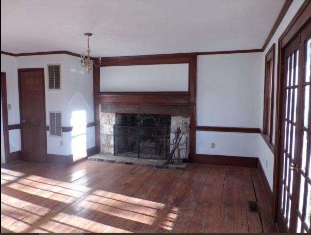
I was very concerned about the condition of the 233 year-old log joists in the house. Rather than relying on an exterminator’s opinion for a house that I expected to raise a family in and live for the rest of my life, I retained a professor from Virginia Tech’s School of Forestry, who specialized in wood diseases and insects to inspect the entire structure.

The professor was astonished to discover that there was absolutely no evidence of insect damage or wood rot in any of the wood structures in the house. All the wood appeared to come from virgin forests and was stronger now than when harvested in 1754 or 1770. He was especially puzzled by the log joists. They were obviously pine, but not any pine that now grows in western Virginia. He noticed that part of one log had been marked for cutting, in order to make space for HVAC supply and return ducts from the basement. If gave him the part of the log to be cut off, he would waive the $500 consultation fee. It was a deal!
I asked around the county. Most people had never even heard of a Southern Longleaf Pine. The few who did, vaguely associated them with South Georgia or northern Florida. In general, the population of Shenandoah County was ambivalent toward history, unless it was something to do with the Civil War.
A few weeks later after the log section had been analyzed under a microscope and genetically. the professor called me with some bizarre news. The log joists in my house were Southern Longleaf Pines. Most still had the bark on them, so they had obviously been harvested from near the house. However, that did not make sense, because the only Longleaf pines in Virginia, grow in a small section in the extreme southeast corner of the state.
Fifteen years later, when I was back to living in Georgia, I came across a book entitled A History of the Valley of Virginia by Sam Kercheval. It was first published in 1833 and based on interviews by Kercheval of the original settlers of the Shenandoah Valley. His book answered all the historical questions that I was never able to get answered while living in the Valley. A reprint of the 1902 edition is available on Amazon.com. It is history from a very reliable author that is highly readable. Kercheval was a well-educated French Huguenot lawyer and historian, who was also an officer in the American Revolution.
Kercheval stated that until the late 1600s, the Valley was densely populated with a very advanced Native American population, who had many cultural traits typical of Mexico. They ground their corn on stone metates and cooked their tortillas on soapstone griddles. They made very sophisticated pottery that was often painted with ornate designs. They wore woven clothing and raised a “sweet” variety of tobacco that is cultivated in Mesoamerica. He said that almost every farm in the Valley contained at least one Indian mound, while many had village sites on them.
My farm was no exception. According National Park Service archaeologists, my farm contained two village sites and at least one mound. The National Park Service archaeologists and historians spent several months surveying my farm, since it was to be a key property within the proposed Shenandoah Battlefields National Historic Park.
The best bottom lands in the Shenandoah Valley were divided into family plots by the Native Americans. The undergrowth and fallen limbs in the stream valleys were periodically burned out to kill saplings and encourage grass to grow. Here the primary trees were widely-spaced sycamores, ashes, maples, poplars, oaks, hickories, dogwoods and redbuds.
For over 200 miles of Virginia’s landscape, the rolling hills that covered most of the Shenandoah Valley’s basin were covered end to end with tall, majestic Southern Longleaf Pines. Again, at these locations, the Indian frequently burned out the brush and saplings, leaving a park-like feeling. Unlike the other forms of vegetation in the valley, however, the Southern Longleaf Pines were dependent on these periodical burnings to cause their seeds to germinate.
Captain John Smith stated in his 1616 book, A General History of New England, Virginia and the Summer Iles that by far the most dense population and culturally advanced peoples lay on the west side of the Blue Ridge Mountains . . . i.e. the Shenandoah Valley. In the 1660s, the population was made almost extinct by British sponsored slave raids and European diseases. Once there was no one to start the brush fires, the Southern Longleaf Pines began having to compete with hardwood species that were spreading nearby stream valleys and mountainsides.
After the French and Indian War ended in 1763, vast numbers of these trees were cut down to construct log houses and provide masts for British ships. The pace of the Longleaf Pine’s destruction hastened after the Revolution as the population of the Valley exploded, while Baltimore and the Chesapeake Bay became a major ship-building region. No one thought of replanting Longleaf saplings and certainly no one realized that annual burnings of the forest floor improved the health of certain tree species.
By the time that Kercheval wrote the first edition of his book in 1833, very few Longleaf Pines remained in the Shenandoah Valley. By the time that he died in 1845, they were near extinction. At least in the Shenandoah Valley, they had gone the way of the large herds of Woodland Bison that once roamed its fertile meadows.
The mountainsides of the Valley were covered in beautiful Eastern Hemlock trees. Once cut down by early settlers, these fur trees were replaced by a wide variety of hardwood trees that are typical of the Virginia Mountains. In most locations, the hemlocks did not return.
Of course, hundreds of species of plants and animals were exterminated by the arrival Europeans to Eastern North America . . . but . . . as you will see in this final section, there is no obvious explanation of why a massive Southern Long Leaf pine forest ever established itself so far north and in such opposite terrain to where it naturally grows today.
The Southern Longleaf Pine
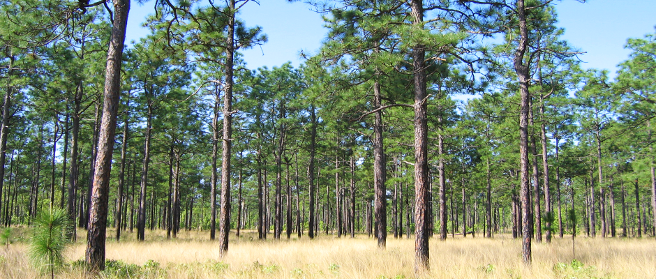
This is what Wikipedia and most of other references tell you: “The longleaf pine (Pinus palustris) is a pine species native to the Southeastern United States, found along the coastal plain from East Texas to Chesapeake Bay, extending into northern and central Florida. This species of pine is largely confined to regions, which consist of flat or near flat sandy soil with a high water table, high year-round humidity, sub-tropical climate and annual precipitation of 50 inches or more.”
“Longleaf pine can reach a height of 30–35 m (98–115 ft) and a diameter of 0.7 m (28 in). In the past, before extensive logging, they reportedly grew to 47 m (154 ft) with a diameter of 1.2 m (47 in).”

“Before European settlement, longleaf pine forest dominated as much as 90,000,000 acres (360,000 km2) of the Southeastern United States. Its range was defined by the frequent widespread brush fires that were formerly set by Southeastern Native Americans. In the late 19th century, these virgin timber stands were “among the most sought-after timber trees in the United States, because of the strength of the wood, straight trunks and resistance to insects. This rich ecosystem now has been relegated to less than 5% of its pre-European settlement range due to clear-cutting practices.”
When I lived in Shenandoah County, VA it received 28 inches of equivalent water precipitation a year and 38″ of snow. Most of the precipitation came in the form of snow during the winter. The ground froze in early November and thawed in late March. The pastures turned brown in July due to lack of water. We had to feed hay to the goats and sheep in July and early August. This was the climate residents of the Valley had known since their first arrival in the 1700s. The Battle of Toms Brook was fought on October 9, 1864 in snow flurries!
Thirty years later and Shenandoah County now gets 37 inches of rain and 28 inches of snow a year. The wettest month of the year is now July. Alfalfa is no longer a major crop in the Valley because the climate has become too humid during the summer months. Wintertime temperatures now run about the same as in the Georgia Mountains and the soil does not permanently freeze in the winter. That is still a climate not warm enough and wet enough for Longleaf Pines to thrive.
And then there is the problem of no flat, sandy soil in the Shenandoah Valley, while a climate like flat, sandy Waycross, GA, averages 0 inches of snow a year, but grows Longleaf pines like kudzu !
You go figure!

Howdy, Great article, I learned more about pine trees than ever before. I have sarcoidosis which is considered normal among blacks living in piney woods. The last doctor who treated me told me the highest % of Sarcoid was in Finnish Firefighters. Which happens to be my Degree and avocation for years.
On Fri, Jan 15, 2021 at 6:31 PM The Americas Revealed wrote:
> alekmountain posted: ” A forgotten Native American civilization converted > the valley into an artificial landscape. by Richard L. Thornton, Architect > & City Planner Theoretically, neither Southern Longleaf Pines nor Eastern > Hemlocks should have been endemic in the She” >
LikeLiked by 1 person
It is also common among the Uchee People (Yuchi) who came from Scandinavia. I have a lot of Finnish and Sami DNA from my Uchee ancestry.
LikeLiked by 1 person