by Richard L. Thornton, Architect and City Planner
One Summer in Mexico ~ Part 74

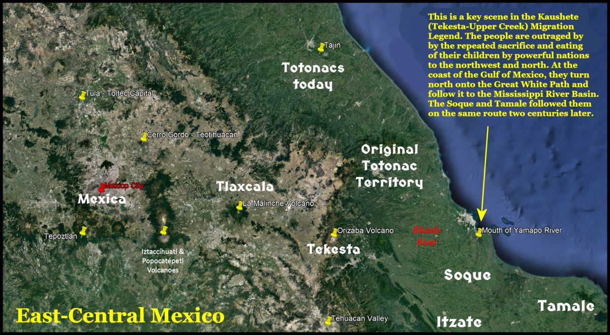
Image at top of article: Note that there is an almost perfect East-West line between Tepoztlan and the mouth of the Yamapo River. The Kaushete-Creek and Soque Migration legends placed branches of the Creek Confederacy in direct contact with the Totonacs and stated that large scale sacrificing of their children and youth was a primary reason for leaving Mexico. The Itza Mayas left Mexico in four main waves. The earliest, around 550-600 AD were fleeing a famine due to volcanic cloud cover. The second wave left after their lands were incinerated by the eruption of the El Chichon Volcano in 800 AD. The third wave fled the suburbs of Chichen Itza after it was captured by Toltecs around 1000 AD. The fourth wave accompanied the Soque around 1200-1250 AD.
The Mexican government has intentionally covered at least two stone ruins with dirt that possibly predate the Olmec Civilization! The archaeologist, who unearthed one of those sites near Tepoztlan, stated that the stone masonry was “different” from the Mesoamerican stonework, which followed it. Are these two sites, locations where the Totonac People evolved?
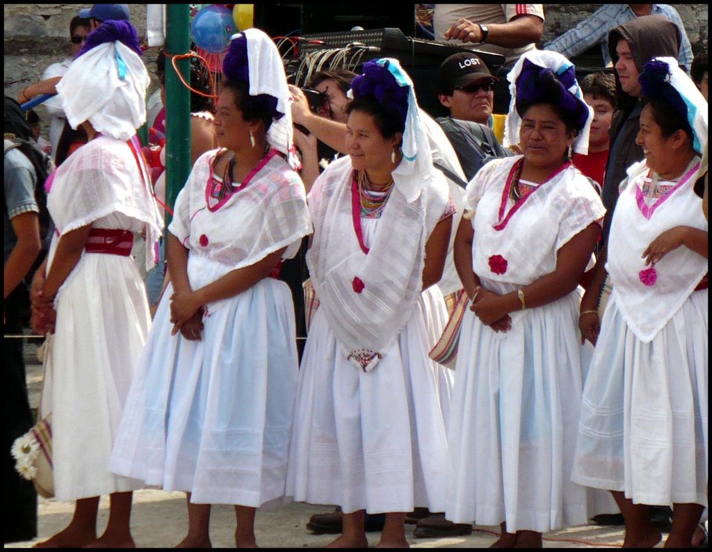
The Totonacs or Tutunacu (tutu = three, naku = heart) are descendants of an important Mesoamerican civilization. The Totonacs mainly inhabit the State of Veracruz and the north of Puebla and the coastal region. The 2020 Mexican census determined that 260,000 people speak Totonac fluently. Mexicans with substantial Totonac ancestry probably number 3-5 million. They live primarily in East-Central Mexico and the Southeastern United States.
Language: The Totonac Language is considered a Language Isolate in Mexico, but in actuality, has never been compared to indigenous languages in the United States or elsewhere in the world . . . only to some major indigenous languages used today in Mexico. Itza Maya contains numerous, borrowed Totonac words, but apparently no anthropologist ever compared it to Totonac. Today, there are three major and one minor dialects of Totonac. There may have been other dialects in the Pre-Hispanic past.

Cultural History: In anthropology textbooks, the Totonacs are included in the “Mexican Gulf Coast Cultures,” without stating which towns or villages in Veracruz were occupied by Totonacs prior to around 600 AD. The current belief is that the peoples, living in central and northern Veracruz traded with the larger towns of the “Olmec” civilization in southern Veracruz and Tabasco between 1400 BC and 500 BC, but were not as culturally advanced.
TV documentaries on the Olmec Civilization do not tell you that the Olmecs were a Nahua people, who arrived in the region about 1500 years after some major cities in Tabasco were abandoned. They also do not tell you that the “Olmec Civilization” cities and towns in southern Veracruz continued to grow for centuries after “the Olmec Civilization” cities and towns in Tabasco collapsed. After about 500 BC, the most advanced city states were in Veracruz, while those in Tabasco shrunk to being villages.
The period between 500 BC and 200 AD is called the Epi-Olmec Civilization. The Olmecs were still nowhere around. TV documentaries tell you that the Maya writing system first was developed by the Olmec Civilization, but don’t tell you that this writing system did not appear until very late in the Epi-Olmec Period. There was an earlier and different writing system. So far, few examples of it in Mexico, but it appears to be the writing system that was the basis of the one used by the Creeks until the mid-1700s. Those Epi-Olmec symbols appear on Creek art and on some petroglyphic boulders in North Georgia. Thus, it is quite likely that the Totonacs originally used the Epi-Olmec writing system.
The Totonacs have always told Europeans . . . since 1519 mind you . . . that they are descended from the elite of Teotihuacan. They were driven out of Teotihuacan during a civil war around 600 AD then founded a great city, now called El Tajin. Mexican references treat this statement as a probable fact. North American references treat it as mythology. The reason that Gringo academicians scoff at this cultural memory is that El Tajin is “over 100 miles away from Teotihuacan.” Teotihuacan controlled an empire that stretched southeastward over 700 miles (1126 km) to southern Guatemala, but the Teotihuacan elite was incapable of walking 100 miles to found a new city?
I did some GIS Maps fact checking. The heart of Tajin is 104 miles (167 km) northeast of the ancient stone ruins atop Cerro Gordo, which I found on the fellowship in Mexico. Cerro Gordo in 2.5 miles north of the Pyramid of the Moon at Teotihuacan. That geographical relationship is no accident. Remember, I even found the stone benchmarks of ancient surveyors on Cerro Gordo, which accurately marked True North, East, South and West.
During the Late Classic Period (600-900 AD), the Totonacs formed a confederation of cities, but, in later times, it seems that they were organized into three provinces: north, south and mountain. Their economy was both agricultural and commercial. They had large urban centers such as: El Tajín ( 300 AD – 1200 AD), Papantla ( 900 AD – 1519 AD ) and Cempoala ( 900 AD – 1519 AD ). These three centers or hearts of their culture produced exceptionally sophisticated ceramics , stone sculpture, and monumental architecture.
Etymology of Totonac: Totonaca is the Spanish name for this people. It is derived from the Nahua word, totonacatl, whichrefers to the inhabitants of the province of Totonacapan or “Totonacs-place of.” The Nahua name from this people is derived from their name for the confederation, Tu’tu-naku, which means “three hears.” However, this was NOT their ethnic name.
Oral traditions and vague origins: The Totonac remember their original name as being Chichini-Kamán (Sun Children). “Children of the Sun” was one of the names that the Uchee People called themselves in the State of Georgia, but their word was Tsoyaha.
Mexican archaeologists believe that the Totonacs can be traced to villages in central Veracruz, which date to about 1400 BC. They may have lived in the region earlier. This is the same region of Mexico, where the Kaushete (Upper Creek) Migration Legend begins. The massive Orizaba Volcano is on the western edge of Veracruz State. The Yamapo (Bloody) River flows from the eastern slopes of Orizaba to the Gulf of Mexico, just south of the city of Veracruz.
There is a major caveat here. The elite of the Totonacs may have been a different ethnic group than the commoners and may have arrived at a different time. That was certainly the case with many branches of the so-called Maya tribes. Totonac princes from Teotihuacan ruled over many tribes and city-states in southern Mexico from around 200 AD until 600 AD. Many royal families after then were descended from Totonac princes.
It is the same situation in the Lower Southeast. Eyewitness accounts of the ancestors of the Creeks in the 1500s and 1600s describe elite ethnic groups living in major towns, while the commoners from several other ethnic groups, lived in smaller villages and on farmsteads. The elites were of mixed Panoan (Peru) and Itza (Mesoamerica) heritage. They spoke a different language than the ethnically diverse commoners.
According to Totonac tradition, their ancestors arrived on the coast of Mexico in large canoe flotillas. Just like the Uchee, the Totonacs believe that their ancestors originated in the “Home of the Sun.” It should be emphasized that while the Uchee clearly meant that the settled at the mouth of the Savannah River after crossing the Atlantic Ocean, the Totonacs could have paddled from the Florida Peninsula. It is now known that the original humans in Cuba came from Florida. The Zoque in southern Veracruz also claimed to have arrived on the coast of Mexico in large flotillas of canoes (or boats?)
The archaeological profession seems content to leave the origins of Mesoamerican civilization a question mark. This is especially true of North American universities. Excavation of Classic and Post-Classic cities in Mesoamerica produce fascinating architectural photographs and showy artifacts. Excavations of ancient villages in which the occupants were cultivating plants, while continuing to hunt, fish and gather wild foods do not produce trophies with which to attract doners.
While at Teotihuacan on my fellowship, I photographed several murals, which were in astonishingly good condition, considering that they dated from around 100 BC to 300 AD. They had to contain attapulgite from Georgia, since there is none in most of Mexico and very little 800 miles away in the Yucatan Peninsula. This leads me to suspect that traders were sailing to the Chattahoochee River Basin by 100 BC or slightly later. The major attapulgite deposits are in SW Georgia, but sooner or later, Mesoamerican traders would have journeyed farther inland.


A concealed architectural heritage in Central Mexico
Cerro Gordo Acropolis: Also, while at Teotihuacan, I climbed up the slopes of nearby 10,000 feet Cerro Gordo. The entire mountainside is covered with the stone walls of Pre-Hispanic agricultural terraces. Once the new high resolution satellite photos of Cerro Gordo became available in 2018, I was able to calculate these previously unknown agricultural lands, overlooking Teotihuacan. The terraces cover approximately 16 square miles, which equates to 12,240 acres or 4, 144 hectares.
At the crest of the mountain, I encountered a fortification wall, constructed of rocks weighing up to several tons. Beyond it was the walls of the acropolis. I could see three levels of stone construction, which looked very different and much older than the stone masonry in Teotihuacan. Later that month, I showed slides of my climb up Cerro Gordo to a Lunch Session in Dr. Román Piña Chan’s office, which included his graduate assistants at the national museum. None of the Mexican archaeologists and anthropology students were aware of the stone-walled terraces and acropolis! Dr. Piña Chan asked for copies of my slides.
In 2018, when high resolution satellite imagery of Cerro Gordo and Teotihuacan became available on Google Earth, I was stunned to see that the Mexican government had COVERED the massive acropolis walls with dirt, so no one could see them. I cannot find any book or website in the United States or Mexico, which mention the massive ruins on top of Cerro Gordo. It is literally a “cover up.”

Tepoztlán stone ruins: During the construction of the Federal Hwy. 115D expressway from Cuernavaca to Cuatla, through Tepoztlán, grading crews uncovered multiple layers of the stone ruins of a town. Archaeologists were brought in from the Institutio Nacional de Antropologia (INAH). They uncovered at least three layers of occupation. However, the lowest level was the most sophisticated stone masonry and composed architecture very different than typical of Mesoamerica. Federal government officials decided to develop the ruins, not destroyed by road construction into a historical park.
Someone in the federal government saw the oldest layer of stone construction and did not like what they saw. The INAH archaeologists were ordered to cover all visible sections of the lowest level and rebuild the walls of more recent Mesoamerican style construction. The archaeological community in Mexico was outraged. Without, government approval, the head archaeologist for the project created a video that described the lowest level of stone masonry. We posted that video in 2018. However, she was soon fired, while the video was apparently removed from Youtube.

Copper battle axes
The archaeological work in Central Mexico, which explores those periods, when civilizations were just beginning to form, is quite rare. Therefore, it seemed that it would be impossible to delve deeper into the origins of the Totonacs. There were few, if any, “facts” available.
THEN, I happed to be reading an account of the conquest of Mexico by Hernan Cortez. The friar stated that 50 Totonac warriors, armed with copper battle axes and daggers, accompanied Cortez on his first visit to Tehnochtitlan. The author mentioned that these axes were a peculiar type of copper, which was a hard as brass, and which kept a sharp blade, much longer than bronze or iron. Eventually, over 2,000 Totonac warriors fought the Aztecs on behalf of the Spanish.
Such a natural form of brasslike copper does exist. The friar was not exaggerating. Natural brass was mined by the Creeks near Dahlonega, GA in the vicinity of present-day Coppermine Road. They obtained the purer, softer type of copper for making ornate copper ceremonial objects from region around Blue Ridge, GA and Copper Hill, TN.
There is no copper ore in the land of the Totonacs. Where in the heck did they get enough “special copper” to make over 2,000 battle axes and 2,000 daggers? The nearest location would have been the Sierra de Cobre (Copper Mountains) next to Tepoztlán. These mountains are no longer being commercially mined, because the impurities, which make that copper natural brass are undesirable for making copper electrical wire.
The next nearest deposits were in Michoacan . . . 350 miles (563 km) to the west. It is highly unlikely that Purepeche would have allowed that much copper to leave their nation, plus it was much purer copper, which would have been softer and more malleable, ergo unsuited for battle axes. Either the Totonacs had close allies or some of their own people living around the Sierra de Cobre.

The pre-Hispanic logo for the city of Tepoztlán was a copper axe on top of an earthen mound, not a stone temple. As mentioned in earlier articles, Tepoztlán was considered by the indigenous peoples of Mexico to be their first city and the birthplace of Quetzalcoatl. They believe that Quetzalcoatl taught the people in Tepoztlán how to make copper axes and how to fight with them. This gave his soldiers a distinct advantage over more primitive peoples, still in the Neolithic Age. They also believe that the “Olmec Civilization” and Teotihuacan were founded by people from Tepoztlán.
Quetzacoatl also taught his people how to play Native American stickball . . . except originally it was played on large fields with curved bats, identical to those used by the Irish and Scots to play hurling.
So, the Totonacs claim to be the founding elite of Teotihuacan and their soldiers used a copper battle axe that originated at Tepoztlán. This is strong evidence that the Totonacs originated as the followers of Quetzalcoatl in the Tepoztlán Valley.

A mysterious connection to northern Norway
Some of the finest petroglyphs in Scandinavia can be found in Østfold County, Norway. It is on the border between Norway and Sweden. From here, southward to the Őresund Channel was the heart of Bronze Age Scandinavia. On the petroglyphs of Østfold can be found all of the types of boats and astronomical-navigation symbols, which are also found on the Tugaloo Petroglyphic Rock at the head of the Savannah River in Georgia, USA.
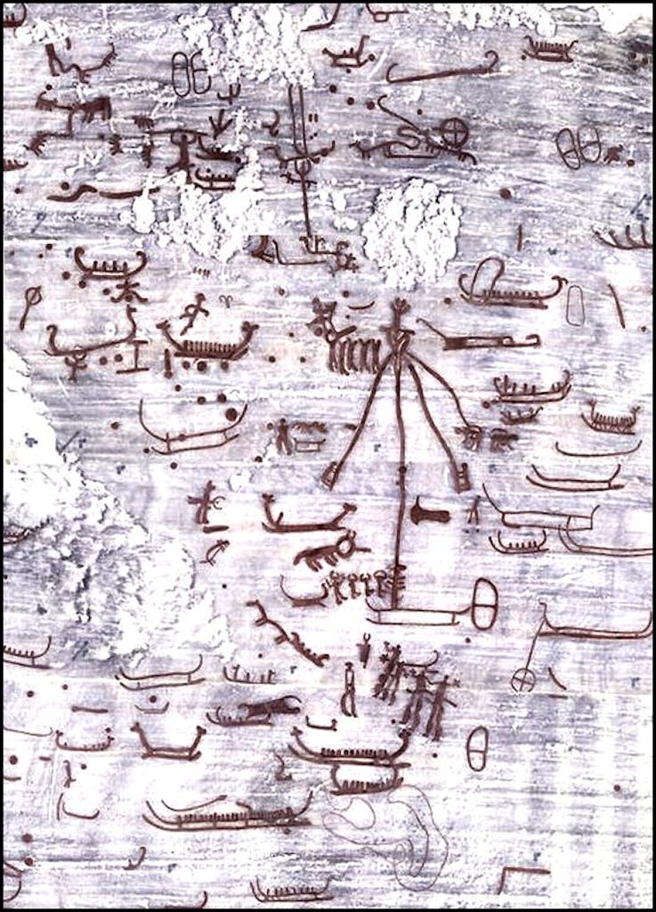
One of the scenes portrayed on these petroglyphs has been little noticed by European academicians, because scholars, who specialize in the Scandinavian Bronze Age are generally not very knowledgeable about the indigenous peoples of Mexico. As you can see below, it portrays a group of Scandinavian Bronze Age explorers observing four men, dressed as animals, circling a timber pole as a man on top plays the flute. This is obviously the famous voladores of the Totonacs. The second part of this scene portrays these explorers running back to their boats as they are being chased by angry Natives.
Now let’s look a little closer at this scene. On the right of the pole, is a symbol which tells us the name of the place, where the Bronze Age Scandinavians observed the voladores. It is the symbol of a copper axe. Shazam!


A lot of good information! Several things stood out and had me curious. 1) On the map there’s the Tekesta. Do you think there is a connection with the Tequesta of Florida? The name is almost identical. 2) For the Mexican government to cover up layers of an earlier civilization tells me it was something that would have put them in a bad situation or it was a civilization from a different country….. we have “ countries “ now and borders. 3) “ Tula” we have a “ Ponchatoula Creek” in Louisiana in Tangipahoa parish. Do those two names sound familiar ? Or might it just be a coincidence. Driving back and forth or the times we have traveled through our state I have become more aware of the names of creeks and rivers. They don’t sound like English names.
LikeLiked by 2 people
Tekesta is just the Creek Indian and English way of spelling Tequista. I think that they are the same people, because both Tequestas were very tall. However, without genetic testing, there is no way to say for sure. Most of the place names in Louisiana are Choctaw or a dialect of Choctaw.
LikeLiked by 1 person
Could there be a possibility that what was covered up have anything to do with the Totonacs?
LikeLiked by 1 person
That is what I am thinking. The Totonacs started the first civilization, but since for 50 years archaeologists have been saying that the Olmec Civilization was first, government officials have been covering up the evidence.
LikeLiked by 1 person
Howdy, GREAT ARTICLE!!! Has the copper axe motiffe shown up at other sites??
On Mon, May 24, 2021 at 7:55 AM The Americas Revealed wrote:
> alekmountain posted: ” by Richard L. Thornton, Architect and City Planner > One Summer in Mexico ~ Part 74 Excerpt of the Original Creek Migration > Legend (June 7, 1735) Image at top of article: Note that there is an almost > perfect East-West line between Tepoztlan and t” >
LikeLike
No, at least according to the Mexican archaeological journals.
LikeLike
Richard, Another Great article. Lots of connections of this stone artwork to a pre-bronze people (But perhaps a Natural Brass people) in Mexico, Sardinia, Spain, Eastern Scotland and Sweden. Noted by lore as Giants in Mexico and Europa. Note the same Bull horn helmets worn by Bronze age people in Sardinia as Sweden? This must go back to when the Bronze age arrived to Sweden.
LikeLiked by 1 person
The petroglyphs in southern Norway and SW Sweden portray Mediterranean style ships coming to their shores to deliver bronze. ingots. The region did not have either copper or tin, so the locals did not know how to make bronze. A huge copper deposit was found in Lapland in the 1600s. That is why the Swedes conquered the Sami.
LikeLike
Regarding the Olmec writing system: You are correct, there was an earlier and different system. The Cascajal block is proof of that. Researchers dated it to between 1100 BC to 900 BC. Here is more info at this link. https://www.jyi.org/2007-february/2007/2/11/olmec-writing-the-oldest-in-the-western-hemisphere
LikeLiked by 1 person
Thank you for forwarding me this link. The Creeks actually have much closer cultural ties to the Olmec Civilization than they do the “Classic Maya” city states in Guatemala.
LikeLiked by 1 person