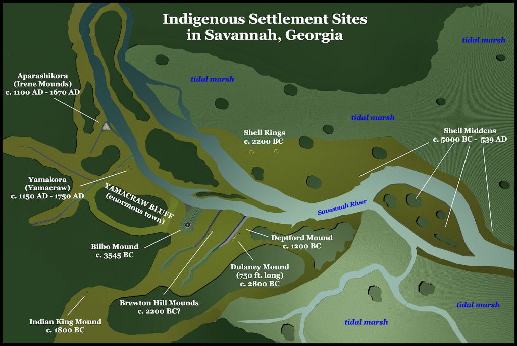
And the site of a mound, canal and harbor, older than any structure in Mexico . . . at least 3545 BC!
The main town was names Yamakora, from which the British derived Yamacraw. The name of fortified elite village on Irene Island, within this large town, was Aparachikora, from which the Spanish derived the name Chicora. The name is Panoan from Peru and means, “From Pará (Upper Amazon Basin) – Descendants of – People.
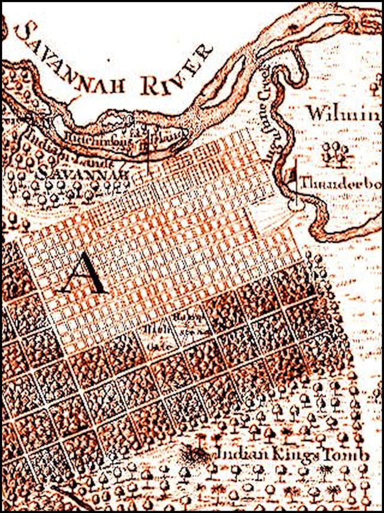
The multi-ethnic commoners lived in what is now historic Downtown Savannah. The mounded tomb of the first High King of the first Creek Confederacy was known, even in 1733. Look at the lower left hand corner of the map below. However, Savannah was dotted by ancient mounds and earthworks, which the Creeks held sacred even though most of their population was by 1733 at least 170 miles to the northwest in the Georgia Piedmont or 250 miles to the west along the Chattahoochee River. Even in the early 1700s, the Creeks called their nation, Paran, which was the plural of the name of the Upper Amazon River Basin. These facts was repeatedly stated by Creek leaders to British officials in the 1700s, but forgotten by academicians and historians after the American Revolution.
Origins of the Chickasaw & Creek Peoples – Part Six
by Richard L. Thornton, Architect and City Planner
Perhaps, what is even more astonishing is that few residents of Savannah are aware of these ancient structures and that the archaeology profession in North America is determined to ignore them. Now . . . if a mound dating to even 1800 BC was discovered in Mexico, the announcement would quickly appear in the RSS newsfeed and then in hundreds of newspapers and news websites around the world within three days. All the archaeology magazines and websites would quickly replicate such information.
So far that has not happened, however, you see . . . the oldest mounds in North America are found in Georgia, with the exception of Watson Brake, Louisiana, which is a century younger than the Bilbo Mound. It is quite possible that the founders of the so-called Olmec Civilization paddled or sailed to the coast of Mexico from the Southeastern United States!
Tamachichi (Tomochichi in English) was somewhat of a real estate scam artist . . . in addition to being the deposed king of the Itsate towns on the Ocmulgee River, near present-day Macon, GA. When he heard that the British planned to found a new colony on the uninhabited site of Yamakora, Tamachichi gathered together approximately 50 multi-tribal followers from the town of Palachicora, which was now about 35 miles upstream from the original location. They built their village near some burial mounds on Yamacraw Bluff in what is now the northwest corner of the Downtown Historic District. That neighborhood is now called Yamacraw Village.
When Supervising Trustee, James Oglethorpe, arrived at the planned site of Savannah on February 12, 1733, he was greeted by Tamachichi, plus John and Mary Musgrove. A Creek heneha (Maya/Creek word for royal siblings) Mary served as Oglethorpe’s translator and cultural guide. The group then toured the land that the Georgia Board of Trustees had initially purchased from Tamachichi . . . land that he could only claim as squatters rights.
Tamachichi pointed out the burial mounds, where he claimed his ancestors were buried. He then stated that his people originally lived in Yucatan then migrated to a large lake in southern Florida then migrated northward to a marshy area with many reeds. That could be the headwaters of the St. Johns River in Florida, Lake Serope (now Okefenokee Swamp) or the Tidal Marshes on the Georgia Coast. From there his people migrated to Yamakora and from there migrated to Ocmulgee Bottoms, where Ocmulgee National Historical Park is now located.
As the group was walking the southern edge of where the initial town would be built, Tamachichi pointed out an ancient mound on the almost flat landscape. He stated that their “first emperor” was buried there. He also stated that the first town of the Creeks was located where Savanah was planted.
On June 6, 1735, Chikili, the High King of the People of One Fire (Creek Confederacy) gave a speech to the leaders of Savannah, which was translated by Mary Musgrove and transcribed by Colonial Secretary Thomas Christie. Chikili specifically stated that the first town and capital of the Creek Confederacy was locate where Savannah was built and that the tomb of their first emperor was located immediately south of the town.

Both Chikili and Tamachichi mentioned that their peoples still remembered when the French came to the Georgia Coast . . . specifically a visit by red haired Frenchmen, when his boat sailed up the Savannah River and visited with the people of Palachikora. That Frenchman was most like Captain René de Laudonnière, commander of Fort Caroline, who in the summer of 1565 visited Palachicora, but called it Chicola. In his memoirs, De Laudonnière specifically stated that Chicola was the same province and capital that the Spanish called Chicora.
Hysteric Preservation Humor
Beware of Creeks bearing gifts . . . they won’t believe you!
As part of the conditions for Prince Charles paying for the high resolution photography of the original documents, handwritten by Thomas Christie, I was to give copies of these photographs to the Georgia Historical Society, the Library of Congress and the Muscogee-Creek Nation.
I tried three times to give these documents to the Georgia Historical Society in Savannah. It started out badly when the first historian, told me, “Oh you’re the Maya guy.” Each time its officials were increasingly rude in telling me that the original documents didn’t exist . . . the last time by slamming the phone down. You see, the newspapers in Georgia was so saturated by slandering articles in 2012 that when the premier of American Unearthed did become available on Georgia TV’s, academicians refused to watch it . . . so these people never knew that the program proved me right.
The Library of Congress bureaucrats referred me from one employee to another for over 30 minutes. They finally informed me that I would have to pay three university history programs of national stature to authenticate the documents. I tried to explain to them that these photos were being paid for by the future King of England. I then emailed the person on the other end of the phone copies of my correspondence with his Assistant Private Secretary, Dr. Grahame Davies, and the staff of the Archbishop of Canterbury. It didn’t matter.
The staff of the Muscogee-Creek Nation told me that they would only accept documents that were approved by University of Oklahoma professors, who were Muscogee-Creek citizens. I sent the lady professor at UO a photograph of the first page of the original handwriting and Mary Musgrove’s translation. She called back to ask, “Who did this translation? It is all wrong.”
I answered, “Mary Musgrove in June 1735.”
The professor responded, “I never heard of her. Sir, we are tired of you white people printing false translations of our language and making up history about us.” She slammed the phone down before I had a chance to respond . . . so that was that. The Poarch Creek Tribe in Alabama asked for and received the documents that the Oklahoma Creeks refused. The National Park Service got the Library of Congress’s copies and my Creek tribe, the Coweta Creek Confederacy of Georgia, holds the copies that that the Georgia Historical Society refused.
Unraveling a concealed past
In early spring of 2013, I received an intriguing email from Boston University graduate, Marilyn Rae. She had intensive credentials in the Romantic Languages and Medieval European History. She also was a direct descendant of Cherokee Principal Chief Pathkiller. . . the last hereditary principal chief of the Cherokee Nation. As I got to know her, I learned that she had grown up in the Shenandoah Valley. She still living in Front Royal, the first couple of years that I was there.

Mary had come across an intriguing French authored book in the Fantasy and Utopia bin of the Carter Brown Library at Brown University. From the illustrations among ten of the chapters, she suspected that at least part of the book by Pasteur Charles de Rochefort, L’Histoire Naturelle et Morale des isles Antilles de l’Amérique was about the Track Rock Terrace Complex. Track Rock was the opening focus of a new series on the History Channel called “America Unearthed.”
The book was also published online. I knew enough French to quickly discern that there were ten chapters about the future state of Georgia, which De Rochefort called Florida Française, in the 1650s. However, the dominant tribe in Georgia at that time was described by the book, as being the Apalache. The book showed the Apalache living in the mountains and Upper Piedmont. Everybody knew that was untrue. There was a good reason to put the book in the Fantasy and Utopia bin.
However, I read on. De Rochefort provided detailed information about the structural details of traditional Creek architecture . . . information that the archaeology profession wouldn’t know until the late 20th century. Maybe he was on to something.
Mary translated those ten chapters precisely. We were astonished to learn of an indigenous civilization that had been left out of the history books, but was “right in your face” on all the Colonial Period maps. It was clear that the Apalachetes as they called themselves were directly antecedent to the Creek Indians, but could get no explanation for why Southeastern anthropologists had concealed their existence. Eight years later, I still have no explanation.

There was still a little doubt in my mind, when Marilyn and I published The Apalache Chronicles in autumn 2013. [Ancient Cypress Press] Although I was able to find architectural evidence that the European colony of Melilot was at Little Mulberry River Park in Gwinnett County, GA, I was never able to find geography in NE Metro Atlanta that matched De Rochefort’s descriptions of the capital of the Apalache Kingdom. This in turn put doubts into the Apalache Migration Legend, recounted by De Rochefort.
Part of my answer came while next doing research for a book on Fort Caroline . . . the massive fortress for a 1000 colonists that the French built at the mouth of the Altamaha River. All colonial maps place Fort Caroline at the mouth of the May River (Altamaha). De Rochefort stated that the survivors of Fort Caroline’s massacre by the Spanish, paddled up stream to the headwaters of the Oconee River. Those survivors were required to marry Apalachete women and were dispersed to several towns.
This explained why I was finding the foundations of 16th and 17th century European houses at several North Georgia Apalache-Creek town sites. The King of Apalache soon was converted to Protestant Christianity. Soon thereafter he created the town of Melilot on a tributary of the Apalache River in NE Metro Atlanta, specifically for European settlers and their Creek wives. Melilot appears on most European maps from 1570 to around 1690. Not one academician or archaeologist (including my mentor, Arthur Kelly!) had the intellectual curiosity to ask why a town with a French name was located in NE Georgia! So . . . everything that De Rochefort said was checking out. It was just that generations of Gringos had ignored what was on the Colonial Period maps.

Over two centuries of an official policy of racial mixing resulted in a wide dispersal of Creek genes among colonists in the Southeast and Texas, plus the spread of European and African genes among indigenous peoples, who elected to maintain their tribal identities. It is possible for genetics labs to discern old European genes from relatively new ones, but this is never done for consumers of “DNA lab kits.”
My discovery of the box of reports by Georgia Colonial Secretary, Thomas Christie, filled in the final chink in the version of history, recorded by De Rochefort. Both De Rochefort and Christies said that many of the divisions of the Creek Confederacy came from the south by water. Both men said that Savannah was the site of the first Creek capital and probably one of the oldest town sites in North America. The only aspect that Christie never guessed was the profound immigration of peoples from South America into eastern North America.

Apalache Migration Legend
The High King of Apalache stated in 1653 that in ancient times many peoples came by water and settled on the coast of what is now lower South Carolina, Georgia and northeast Florida. The Uchee were already living in many parts of the Southeast at that time. Most of the immigrants came from South America . . . including the real Apalache and the people, who the Spanish in Florida call Apalache. The first capital of these Sea Peoples was at the mouth of the Savannah River.
The Apalachete first became distinctive from other South American immigrants, while living in villages around the edge of Lake Tama in central Georgia. This was a shallow, 21 mile (34 km) long body of water, created by the confluence of the Oconee and Ocmulgee Rivers. The lake started shrinking in the late 1600s, when a massive flood caused the Ocmulgee to cut through a natural barrier that backed up the water. All that remains today of the lake is the Little Ocmulgee River Swamp.
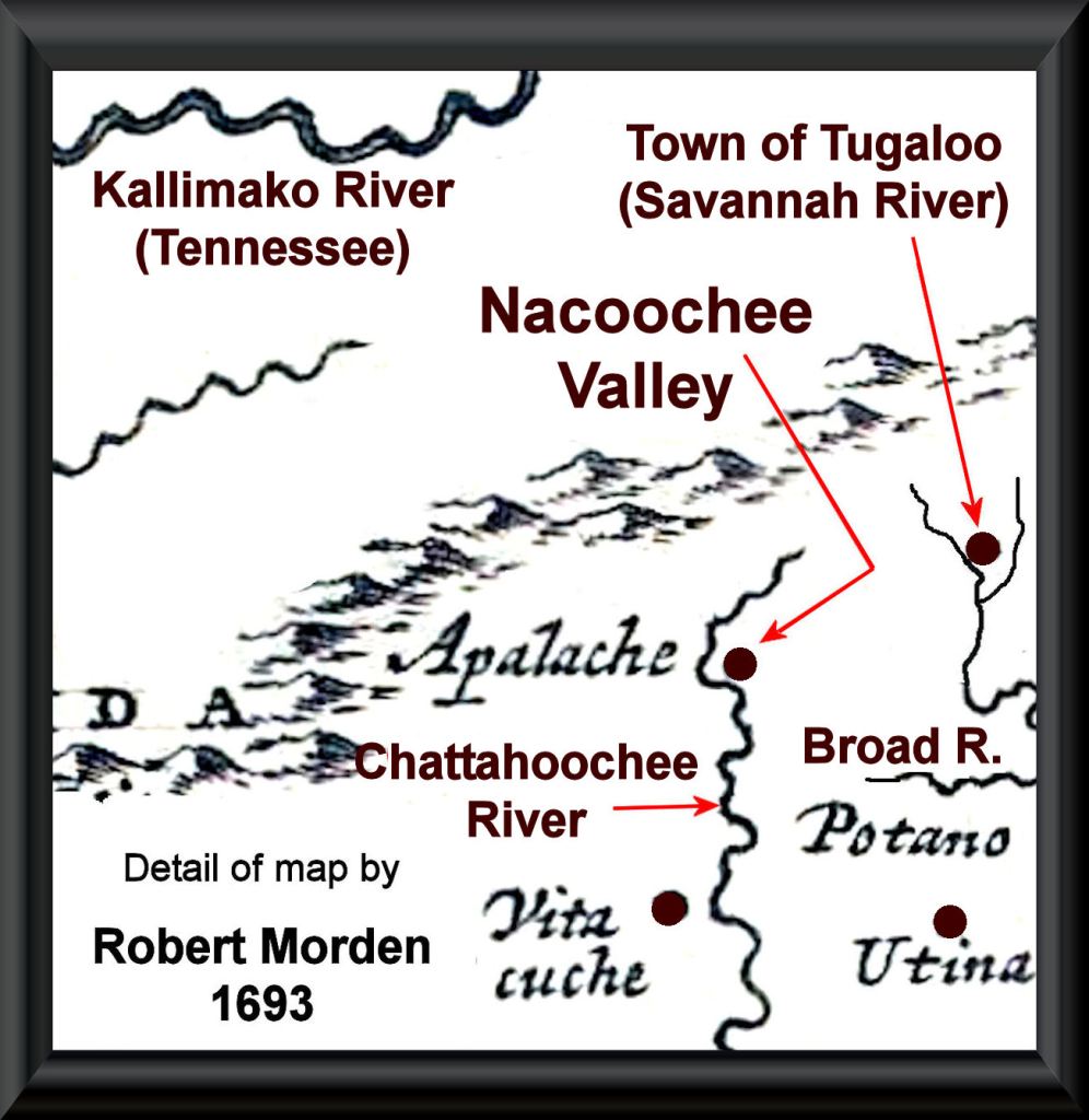
The Apalache moved northward and apparently were the founders of the great town that is now called Ocmulgee Mounds. It was at this time that nearby “Indian Springs” became sacred to them and subsequent Creeks. Upon the arrival of many people from Mexico at the Ocmulgee capital the Apalache began moving northward, building new capitals along the way. They eventually concentrated their villages along the Apalachee, Mulberry and North Oconee Rivers. At this time, they were the most powerful of the vassals of the Itsate, whose capital was in the Nacoochee Valley.
Eventually, the Apalachete conquered the Itsate and the Sokee. They then moved their capital to the Nacoochee Valley. At this time, the Apalache created a massive kingdom, which stretched from southwestern Virginia to southwestern Georgia. A uniform, highly sophisticated style of pottery was produced throughout the kingdom, which archaeologists call the Lamar Culture. The capital of Apalache continued to appear on maps until around 1700 AD. There was a horrific smallpox epidemic in 1696, which wiped out much of the population of the Southern Highlands – presumably both indigenous and European.
The conversion of the Apalachete elite to Protestant Christianity in the 1570s caused a great deal of social discord, mainly fomented by the priests of the old religion, who suddenly lost power and ceremonial importance. Eventually, the kingdom broke down into what was really a confederacy. The king of Apalache lost most of his political power and was viewed more like the world today views the Pope of the Roman Catholic Church. However, the practice of the Apalache’s allowing foreigners to settle in their realm gave the Apalachete a technological edge, which spurred their economy despite the lost of coercive power by its leaders.
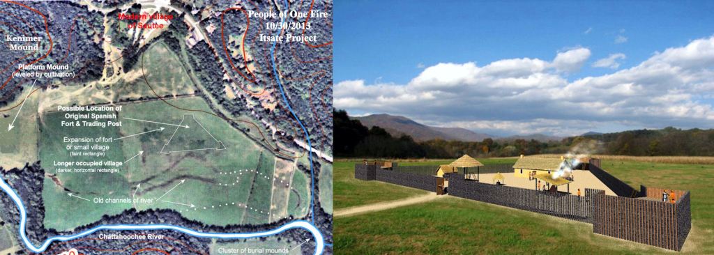
At the time that Richard Brigstock visited Apalache in 1653, the king had developed much better relations with the Spanish governor in Florida. In return for the Spaniards’ promise not to harass Protestants and Jews in the Southern Highlands, they were allowed to build a fortified trading post and mission in the Nacoochee Valley. The footprint of this facility appears as a triangular fort and rectangular village on a tract in Sautee, which is now the Chattahoochee Stables. Catholic Spanish gold and gem miners were also allowed to settle in their realm, as long as they married Apalachete women.