Their villages were identical to those of the Chontal Maya in Tabasco and Campeche, but their exquisite stamped pottery originated in Peru.
by Richard L. Thornton, Architect and City Planner
The Origins of the Chickasaw and Creeks – Part 11
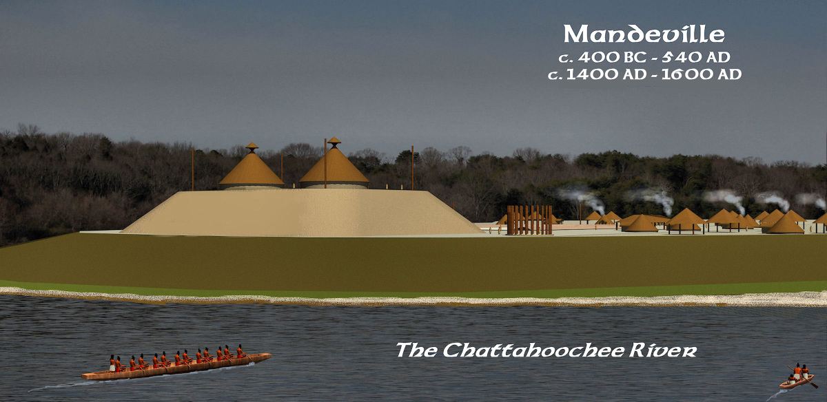
The Swift Creek Culture was named after an archaeological site near Swift Creek in Macon, Georgia. From 1934 until the mid-1960s, archaeologists assumed that this culture began in the vicinity of Ocmulgee National Historical Park. It was then discovered that the oldest Swift Creek pottery was made at the Mandeville Town Site on the Lower Chattahoochee River. However, archaeologist Arthur Kelly could never determine who the newcomers were that introduced the fully developed pottery style to the locals.

Swift Creek Pottery was some of the most ornate and technologically advanced ceramics, every produced in North America. The complex three-dimensional patterns were created by slapping carved wooden paddles or fired ceramic cylindrical seals against the soft clay of newly formed pottery. Trust me! It is very difficult to create a perfect, continuously decorated surface that way, but somehow the potters developed the skills to do so. I have not, so far.

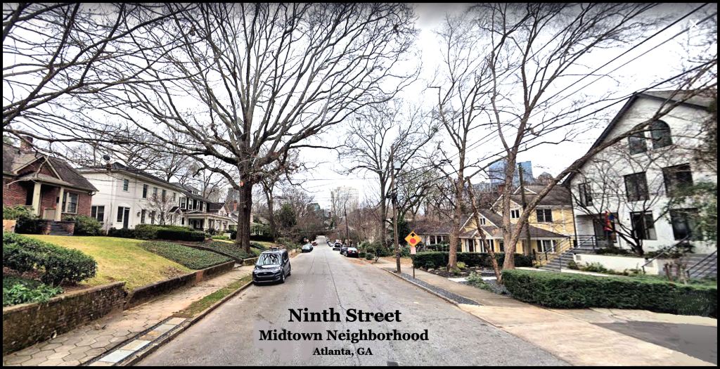
It was the last time that I ever spoke to Dr. Arthur Kelly. In the spring of 1974, my new neighbor on Ninth Street in Midtown Atlanta was none other than my former faculty advisor at Georgia Tech, Ike Saporta. * He invited me to present a slide lecture on my travels in Mexico to the Atlanta Archaeological Society at an auditorium on the Georgia State University.
Ike was still president of the organization and the event was heavily publicized. Well, over 200 people attended, including several Georgia Tech professors, plus most of the anthropology professors and archaeologists in the Atlanta Area. Ike made a point of inviting Dr. Kelly, since his endorsement had clinched me getting the first Barrett Fellowship, which enabled me to go to Mexico.
*Forgotten modern history
Perhaps I should backtrack a bit. Things were going well in Peachtree City until October 6, 1974 – the beginning of the Yom Kippur War, when Egypt, Syria, Jordon and Iraq simultaneously attacked Israel without warning. American oil companies essentially committed treason, by bowing to Arab pressure to cease delivering petroleum to the United States. By the last week of the war, the US was running out of gasoline.
Nationwide rationing began. Peachtree City’s only gasoline station was allotted enough fuel to supply the 793 people, who lived there in 1970. The planned newtown now had over 2,000 residents. Sales of houses in Peachtree City stopped cold. PTC was 38 miles from Downtown Atlanta. Its developer stopped all contracts with our company. I was transferred temporarily back to the Columbia, MD. I had already started night time classes at Georgia State for a masters degree in Urban Planning. My two professors kindly let me to do studies of commuting and recreation patterns in Columbia, in lieu of classwork. Our office moved to Atlanta, so I put my PTC townhouse up for sale then moved to Midtown Atlanta.
A few days after settling into my apartment on Ninth Street, I ambled down the sidewalk a couple of house lots, when I spied a plump, jolly looking man standing on a second floor deck, with a towel wrapped around him. He obviously had been sun-bathing in the nude. We instantly recognized each other. He informed me that I was a professional now and should call him Ike, not Professor Saporta. His daughter, Maria, came out to apologize for her father being nude, except for a towel. She was all grown up now- not the skinny teenage girl, who used to hang around the architectural design labs.

Arthur Kelly updates me
After my presentation, Kelly was not terribly interested in chatting with the archaeologists, who had back-stabbed him in the autumn of 1969. He did greet the Georgia Tech architecture professors then corralled me away from the crowd. He first said that I was probably wise to be getting a masters in urban planning rather than a PhD in Anthropology. I would be assured of having a job.
He then told me that after 50 years, new archaeological work had been going on at the Great Temple Mound and at the Lamar Village Site at Ocmulgee National Monument. The information was radically changing his understanding of parts of this enormous archaeological zone. From then on, I quickly scribbled down the key dates that Dr. Kelly was giving me and afterward placed the notepaper in a Kodak slide carousel . . . where they would lay until 2019 AD, when I began digitizing my slides from Mexico.
The base of the Great Temple Mound was firmly dated to around 900 AD, but was built over an earlier burial of a leader. There was an infusion of another ethnic group around 1000 AD, who built large rectangular houses and re-planned the acropolis to closely resemble Mesoamerican towns. The famous Earth Lodge was burned and covered with clay around 1010 AD – perhaps by the newcomers. Surprisingly, the Swift Creek Village on the edge of the acropolis, high above the Ocmulgee River, was never really abandoned, but morphed into being a neighborhood of the large new town. Kelly stated that all Swift Creek villages south of this one, were suddenly abandoned around 550 AD. This is important information, which will be analyzed later in the article.

The town of Itchesi (Lamar Village) was actually settled around 990 AD by the same people, who at the same time had settled Etowah Mounds. They seemed to have come from the south somewhere. Beneath the Mesoamerican style town that is visible today, however, was a Swift Creek Culture village, which had been abandoned around 550 AD. Still to this day, however, a sign tells visitors at the Ocmulgee Museum that the Lamar Village was founded around 1250 AD.
Dr. Kelley explained that when they were working on the Lamar Village site, they had encountered a 2-3 feet strata of “sterile” alluvial soil and stopped there. The lowest level of artifacts was therefore dated to around 1250 AD. The 1973-1974 National Park Service team had continued downward through the sterile soil then encountered more artifacts. They obtained radiocarbon dates for each occupation layer. There was also once a small Deptford Culture village or seasonal camping ground on the site.
The NPS archaeological team determined that there had been catastrophic floods at the Lamar Site around 550 AD and 1200 AD. Both Itchesi and Etowah had been originally built on the tips of horseshoe bends, but the catastrophic floods on both the Ocmulgee and Etowah Rivers in 1200 AD had converted both town sites to islands. This is the reason that much of the original town at Etowah was on the south side of the river.
Swift Creek Culture may have begun as a single potter
Near the beginning of my presentation at Georgia State University, I mentioned that Curator at the Museo Nacional de Antropologia, Dr. Román Piña-Chan, felt strongly that Mesoamerican commoners and/or escaped slaves had settled in large numbers in the Lower Southeastern United States. He explained that the influx seemed to have been predominantly male, because Georgia’s Mississippian Period architecture and public art was clearly Mesoamerican in origin, but the unique complicated stamp pottery of Georgia was unknown in Mexico.
At least, 90% of the pottery produced in the Maya lands was shell-tempered Redware. Shell-tempered Redware also predominated the pottery in and around Ocmulgee. Neither I nor Dr. Piña-Chan knew that in 1970. It was also fairly common elsewhere in the Lower Southeast after 1000 AD , but seldom mentioned in North American anthropology books. Actually, the Maya redware is seldom mentioned in Mexican books, too!
Kelly asked me if Dr. Piña-Chan ever told me where he thought the Complicated Stamp pottery originated. I told him, “no.”
He then explained that the archaeological record of Swift Creek Complicated Stamp pottery began as a few pots at the Mandeville Site on the Lower Chattahoochee near the mouth of Pataula Creek. They were dated to around 100 AD and represented only about 1% of the pottery, produced at Mandeville, during that time period. For the next century, the pottery style became more and more common at Mandeville then beginning spreading northward around 200 AD.
Kelly was certain that it originated somewhere to the south, but could find no evidence of it being made farther south in Georgia in Florida at an earlier date. In fact, the Mandeville Mounds still marked the boundary of the Creek Indians until the early 1700s. This was important information for my quest in 2021!
Kelly then described changes to the understanding of the Swift Creek Culture, since we first chatted on the subject in the spring of 1969. It had not begun at Ocmulgee as most archaeologists still assumed in the 1960s, but at the Mandeville Site on the Lower Chattahoochee River. The Swift Culture People had first expanded up the Chattahoochee River with closely spaced villages and regularly spaced towns all the way to the northern edge of Helen, GA at the headwaters of the Chattahoochee River. These people or at least their cultural traits then expanded eastward, westward and southward.
Something strange happened around 550 AD. ALL of the Swift Creek and Weeden Island Culture villages, south of the Fall Line* were suddenly abandoned. People came back to Kolomoki Mounds in extreme southwest Georgia, but the population was never the same. The Woodland Period town was fully abandoned by 750 AD. However, the Swift Creek population in Southeast Georgia seemed to be wiped off the face of the earth. It appeared to be a “mass extermination event,” but only downstream from the Fall Line.
At the same time, new Swift Creek Culture villages and towns appeared in the Upper Savannah River in Georgia and South Carolina, plus the Upper Hiwassee River in Georgia and North Carolina. These two areas were the last to produce Swift Creek style pottery, but that ceased around 1000 AD.
*This is a fault line that separates igneous rock from sedimentary rock from eastern Alabama to Maryland. The sedimentary rock is softer, so it is typical to find waterfalls, where rivers cross the fault.
A dying profession, devoid of intellectual curiosity
To understand why so little new knowledge about the Swift Creek Culture has been obtained, since my chat with Dr. Kelly in 1974, one has to look at the state of the anthropology profession in the region, where the Swift Creek Culture existed. After making fools of themselves before the national and state media during the “Maya-Myth-Busting-In-the-Mountains” public relations program, the profession collapsed. That it even exists at all in the Southeast now is a federal program, called Section 106, which requires professional archaeologists to examine archaeological sites prior to them being destroyed by federally-funded construction projects.
Take a look at the Georgia Council of Professional Archaeologists website. It announces that there will be a meeting on November 23, 2019. Apparently, too few people came to even justify taking minutes. The website remained unchanged after that announcement.
Perhaps a half million? college students in the USA have graduated with degrees in anthropology, Native American Studies or Native American linguistics. Not one ever thought of comparing the words in a Creek dictionary with dictionaries of indigenous languages of Mexico.
I became curious, when I noticed that the houses in Etowah Mounds a thousand years ago were identical to the houses built by Totonacs and Itza Mayas, when I was in Mexico. Turns out that the word chiki means a vented, summer house in the Totonac, Itza Maya and the Creek languages. It is derived from a Maya word that means “to weave a basket.” Most Americans would recognize the meaning of a “Seminole chikee” without a dictionary. In other words, it never dawns on the surviving anthropologists and archaeologists that it is possible to translate a Native American place name or solve a riddle, such as the depopulation of South Georgia around 550 AD. I did.

Why the sudden disappearance of Coastal Plain Swift Creek villages?
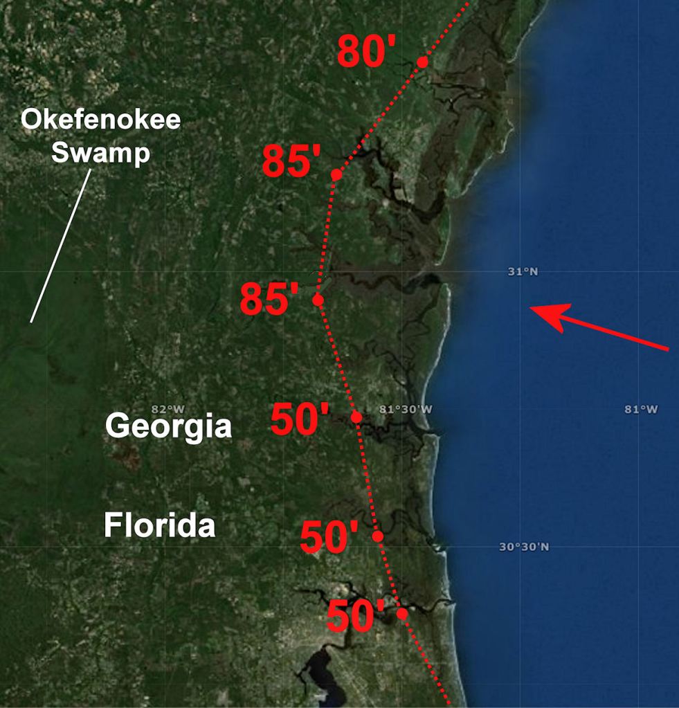
As a young boy, growing up in Waycross in Southeast Georgia, I remember distinctly a tall ridge that seemingly rose out of nowhere, about 11 miles west of the edge of the tidal marshes at Darien, GA. While searching for the actual site of Fort Caroline (1564-1565) I sought a location that was 11 miles west of Altamaha River’s mouth and had a view of a “small mountain” as Fort Caroline’s Commander, Captain René de Laudonnière described. I discovered that a sandy ridge, 85 feet tall at Darien, extended from Savannah to south of Jacksonville, FL. The bluff on which Downtown Savannah is constructed was the tail end of the ridge. It was obviously a tsunami debris ridge, but not ONE geologist had ever noticed its existence . . . at least enough to discuss in writing.
Slightly over a thousand years ago the coasts of North America and Western Europe were devastated by the impact of an object or objects from space. Hundreds of thousands of people were killed by a combination of superheated steam and supersonic particles in North America, followed by sudden wall of water that came crashing down on communities in North America and Europe a few hours later.
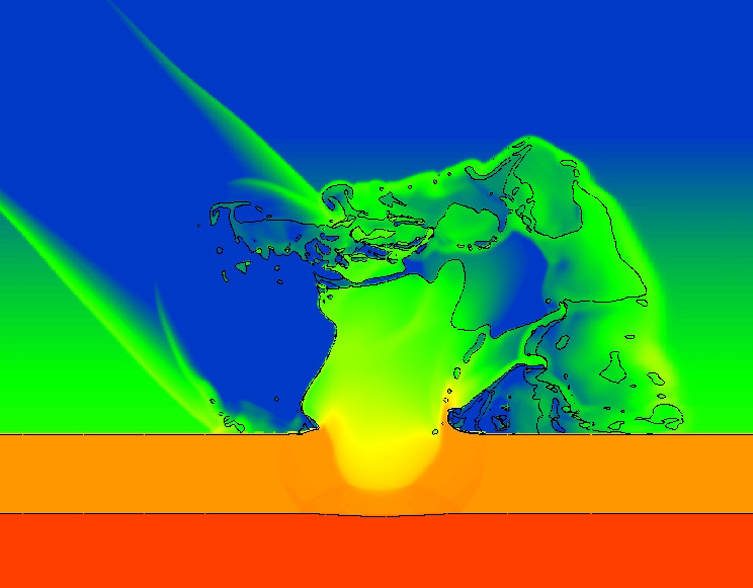
A recent computer simulation was carried out by the scientists of the Sandia National Laboratory in Albuquerque, New Mexico. It calculated the impact of a comet striking the North Atlantic Ocean at a speed up to 150,000 mph (241,401 km/h). All humans living near the coast from Newfoundland to Florida would have been exterminated.
In Georgia, the tidal surge would have pushed up the Altamaha River to the Fall Line. The large lakes near the Fall Line, seen by early explorers of South Carolina and Georgia, probably were 500 year old vestiges of a massive comet strike in 1014.

Geologists have recently discovered evidence that an earlier comet strike and tsunami in 539 AD, combined with volcanic eruptions, probably had an even more catastrophic impact on the world. The natural disaster brought down several civilizations in the Americas and triggered the Dark Ages in Europe.

Evidence in Europe
European scholars have always known about the records of a massive wave of water that swept up the rivers and estuaries of northwestern Europe on September 28, 1014. That would be September 22 in the calendar used today. Historians in each country affected probably assumed that the tsunami was a local phenomenon until recent years, when they began comparing notes. There was no mention of earthquakes prior to the tidal wave. They suspected that something extremely large or a cluster of large objects struck the North Atlantic Ocean, but initially couldn’t prove it.
Dr. Simon Haslett, a geology professor at the University of Wales has been studying the accumulating evidence produced by other geologists, and also historians. In 2012 he found evidence of tsunami damage along the coasts all continents that adjoin the Atlantic. He also found absolute proof both in geological and historical records of a smaller tsunami that killed thousands of people along the coasts of Cornwall, Wales and Ireland on January 20, 1606 AD.
The Anglo-Saxon Chronicle tells us that in England 1014 AD, on the night of St. Michael’s day (September 28, 1014) “came the great sea-flood, which spread wide over this land, and ran so far up as it never did before, overwhelming many towns, and an innumerable multitude of people.” It is estimated that about 80,000 people died in the British Isles from this wave. The numbers may have been higher, because Irish and Scottish geological records indicated even more catastrophic effects on their Atlantic coasts. However, there is less specific information about which towns and villages were destroyed. Several credible observers stated that there was a blue haze in the night time sky for many years after the tidal wave.
Other Medieval records confirm the geological evidence. William of Malmesbury in “The History of the English Kings” (vol. 1) states, “A tidal wave, of the sort which the Greeks call euripus, grew to an astonishing size such as the memory of man cannot parallel, so as to submerge villages many miles inland and overwhelm and drown their inhabitants.” A sea flood is also mentioned in the Chronicle of Quedlinburg Abbey (Saxony), where it states many people died as a result of the flood in the Low Countries (Jutland, Holstein, Friesland, the Netherlands and Belgium) in 1014.
The 1014 tsunami in North America
Now geologists in North America are finding solid evidence that the effects of the 1014 tsunami or a cluster of tsunamis in that year were even more catastrophic on the Atlantic Coast. The impact was so violent that extraterrestrial debris splattered inland along the coasts of Canada and the United States southward to the islands of the Caribbean.
Forensic geologist Dallas Abbott of the Lamont Doherty Earth Observatory at Columbia University has found evidence of a large meteor or comet strike in the middle of the Atlantic Ocean, which hurled extraterrestrial debris over 3800 km (2361 miles) to a bog in the Black Rock Forest in New York. The material was dated to around 1014 AD.
Abbot also found debris from a meteor or comet strike in the Lesser Antilles in the Caribbean Basin that also dated to 1014 AD. Evidence of such a mega-tsunami during the early 11th century in the Atlantic Ocean is undoubtedly also lurking along the coastlines of Virginia, South Carolina, Georgia and Florida.
In 2007 a team of North Carolina geologists, led by Stephen Culver, Kathleen Ferrell and Benjamin Horsea, published evidence that the coastline of their state had once been protected by a chain of barrier islands and tidal marshes such as those that shield the mainland of Georgia. Either a Class 5 hurricane or a tsunami had destroyed these islands in the 11th century.
The Outer Banks are the remnants of these islands, which were splashed back by the ripples of a tidal surge or tsunami. These geologists are further concerned that multiple fractures in the Continental Shelf could cause the Outer Banks to slide into the ocean, creating a mega-tsunami.
The scale of this 1014 disaster would have had a major cultural impact on the indigenous peoples of the Americas. There are stone inscriptions of a great flood along the coast of Mexico and Central America in the early 11th century AD. It is possible that the Aztec legend of the death of the Fourth Sun originated in the cataclysmic events of 1014 AD.
Since the late 20th century archaeologists have known that many new communities appeared in what is now the Southeastern United States in the period between 1000 AD and 1050 AD. They cultivated several crops indigenous to Mesoamerica and South America. They introduced much more sophisticated architecture and town planning concepts. Newcomers also appeared at a thriving village near the confluence of the Mississippi and Ohio Rivers, now called Cahokia, during that era. By 1050 AD the newcomers were razing the original village and building a city on a grand scale. Was massive destruction along the Gulf Coast and in the Caribbean Basin associated with these stark changes?
Currently, the earliest radiocarbon date for the Track Rock Terrace Complex in the Georgia Mountains is c. 1018 AD. It is undoubtedly no coincidence that the construction of that particular terrace followed the tsunami and multiple meteor strikes. What better location to avoid a wall of ocean water coming at you?
Research into the 1014 AD disaster reveals an earlier one
Once ice cores in Greenland and Iceland had revealed a massive spike of atmospheric ammonia levels in 1014, scientists decided to go further into the past. It has been known since 2010 that massive volcanic eruptions during the 530s AD in Mexico and Iceland left large level of trace minerals in the Arctic ice sheet. This caused the scientists to originally miss something else going on in 539 AD.
In 2013, Dr. Robert Dull of the Environmental Science Institute at the University of Texas in Austin announced results of tests, which indicated that the Ilopango volcano in El Salvador kicked off a period of cooling in the world’s climate. In 536 at least two large volcanoes also erupted in Iceland. For decades afterward a bluish haze over the northern hemisphere and tropics caused famines and probably a horrific plague. A strain of bubonic plague began in China and by 540 AD wiped out somewhere between 30% and 50% of the population of the old Roman Empire. This “Little Ice Age” ushered in the Dark Age of Europe and made the Eastern Roman Empire far more vulnerable to future invasions by Islamic armies.
In 2009, Dallas Abbot of Columbia University found nodules associated with a major asteroid or comet strike at the “500s AD level” of the Greenland Ice Shelf. She insisted that either a comet or asteroid played a role in the climatic catastrophe. In 2010 a Greek archaeologist, Dr. Amand Laoupi, reinforced Abbot’s theories by revealing a second ammonia spike in the Arctic ice shelf in 539 AD. The spike was clearly unrelated to Icelandic volcanic activity.
When a large meteor, asteroid or comets strikes the ocean, intense heat and mechanical energy, plus several gases are released into the atmosphere. These gases are trapped in the Arctic and Antarctic ice caps. Volcanic eruptions leave several chemical traces in the ice caps; primarily sulfates. There was an enormous ammonia spike in 1014 AD. Volcanoes do not emit ammonia.
In 2013 two scientists in Japan, Haruna Sugahara and Koichi Mimura, finally answered the question of whether the catastrophic strikes in 539 AD and 1014 AD were meteors or comets. It was already known that comets were essentially dirty ice balls that contained the type of debris which could become the type of nodules that Dallas Abbot had found in several locations along the Atlantic Coast.
In 1994 chunks from the Shoemaker-Levy Comet crashed into Jupiter, creating massive explosions, visible on earth. The largest explosion was the width of the planet Earth. The Japanese scientists’ analyzed the electro-magnetic waves emitted by these explosions. Shoemaker-Levy contains large amounts of frozen ammonia. A super-sized comet striking the Atlantic Ocean could have both caused gargantuan shock waves and filled the atmosphere with ammonia.
The recent computer simulations by the Sandia National Laboratory found that superheated steam, ammonia and the solid particles within a comet would be ejected at sub-orbital velocities into the edge of the exosphere (space.) This would cause them to be more equally spread around the globe than the pollution from volcanoes. The combined effect of both the comet and the volcanoes would be sufficient to cause a Little Ice Age on earth AND chemically disrupt the photosynthesis of plants for many decades. The presence of ammonia high in the atmosphere would explain the blue haze that enveloped Earth for several years after the 1014 AD.
Cultural collapse in Eastern North America
The decline of the Hopewell Culture in the late 400s AD is widely known. Construction at Hopewell sites outside Ohio is believed to have halted a little later by 500 AD. However, the precise date of the last Hopewell construction has never been fixed. The disappearance of the Hopewell Culture has been linked to a series of volcanic eruptions in Mexico and Central America that rapidly cooled the climate of that part of the world.
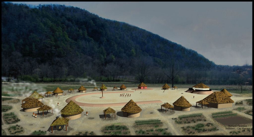
The sudden decline in the mid-500s AD of the Swift Creek Culture . . . an advanced, Native American society of town builders in the Lower Southeast is less well known. These people lived in towns with large mounds unlike the Hopewell People, who lived in transient villages. The Swift Creek towns were generally located in or near fertile river bottom lands. This suggests that they were seriously into farming. The best known Swift Creek towns are today called Leake Mounds, near Cartersville, GA (northwest mountains) and Kolomoki Mounds, near Blakely, GA (Gulf Coastal Plain.)
Unlike the Hopewell Culture, the Southeastern towns and villages seemed to be thriving up until the early 500s. Something caused the sudden abandonment of the villages below the Fall Line.
During that same period, people in Kolomoki Mounds began living in underground homes, known as keyhole houses. The Gulf Coastal Plain has a humid, sub-tropical climate. Before and after the keyhole house period, Native Americans in the region lived in lightly structured huts that were designed for ventilation. These lightly structured houses left very few traces for archaeologists to uncover. Burrowing into the ground is something one does to say warm when it is cold outside.
Three hundred miles to the north at the Leake Mounds near Cartersville, GA, archaeologists did not find any keyhole houses, but the population dropped suddenly. Many villages and towns that had been occupied since 200 BC-100 BC were abandoned in that region.
Architectural evidence suggests that the climate in the Scioto River Basin of Ohio became so bitterly cold during the late 400s and early 500s AD that humans had no time or energy to maintain ceremonial earthworks. Three hundred and seventy miles southward in northwest Georgia, the climate chilled to the point that agriculture was not possible, so people dispersed into hunter-gatherer villages. Three hundred miles farther south in Southwest Georgia, gardening was still possible, but winters were like those normally seen in the Great Lakes Region.

What was the ethnicity of the immigrant Swift Creek potters?

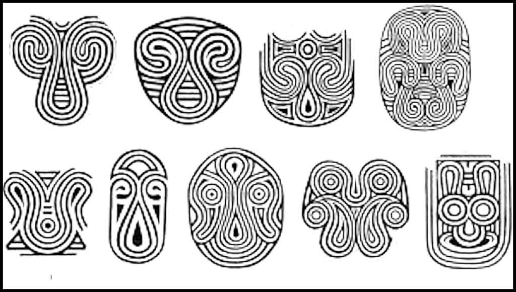
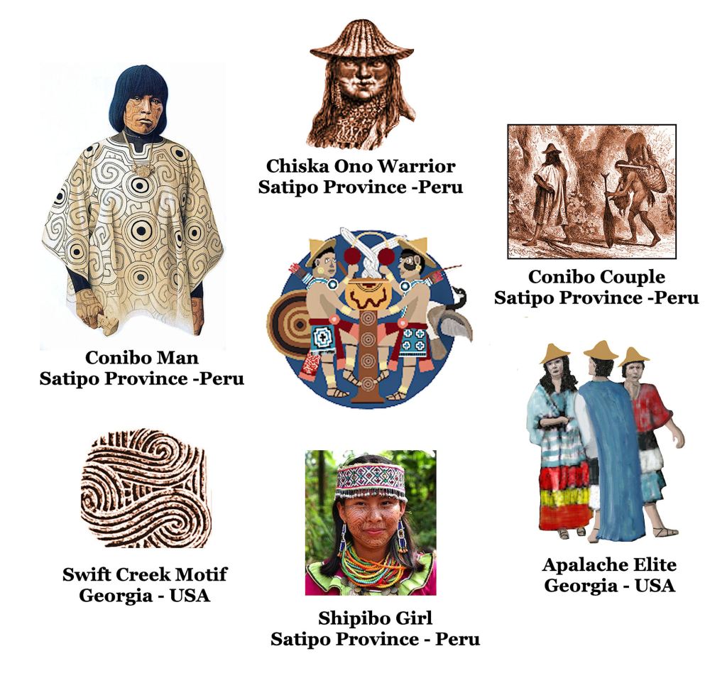
The seemingly difficult question turned out to be quite easy to solve, once I knew that South Americans immigrated to eastern North America and that my family was part Panoan, from Peru. As you can see below, even today the Conibo People of Eastern Peru make clothing in which designs absolutely identical to Georgia’s Swift Creek pottery are stamped onto the cloth or painted onto their faces.
The closely related Shipibo People create clothing and paint geometric designs on their faces, which are identical to the Napier Pottery Style, which followed the Swift Creek Style. The names of both tribes appear as place names in northern Georgia, eastern Tennessee and western North Carolina. There is no doubt about it.
And now you know!

It’s amazing the clues that are left of civilizations on each layer of earth. It’s like a timeline of events. It’s the 🌍 memory box. These natural disasters were undoubtedly catastrophic for it to affect several continents and would explain why all of a sudden entire villages would abandon their homes and commence elsewhere. It am sure it also took many to think outside the box and compare evidence to determine the outcome of these disasters on the people affected and the ones that survived. Thanks for sharing!
LikeLiked by 2 people
My goodness Richard, you have certainly done some research for this post. I was particularly interested in the pottery because this is mostly what I studied in the archaeology.finds. The impact from floods and maybe comets you talk about are quite scary,as a matter of fact only this week we have had 2 earth tremors here on Crete and not far from us The pottery plates and other articles on my dresser shook quite strongly but fortunately didn’t fall and break. Thanks for this very interesting post.
LikeLiked by 1 person
The comets or asteroids are a fact. Granules from the 1014 AD impact are endemic on Manhattan Island in New York City. Northwest Georgia even has craters filled with water, where pieces from the object struck further along on its trajectory.
LikeLiked by 2 people
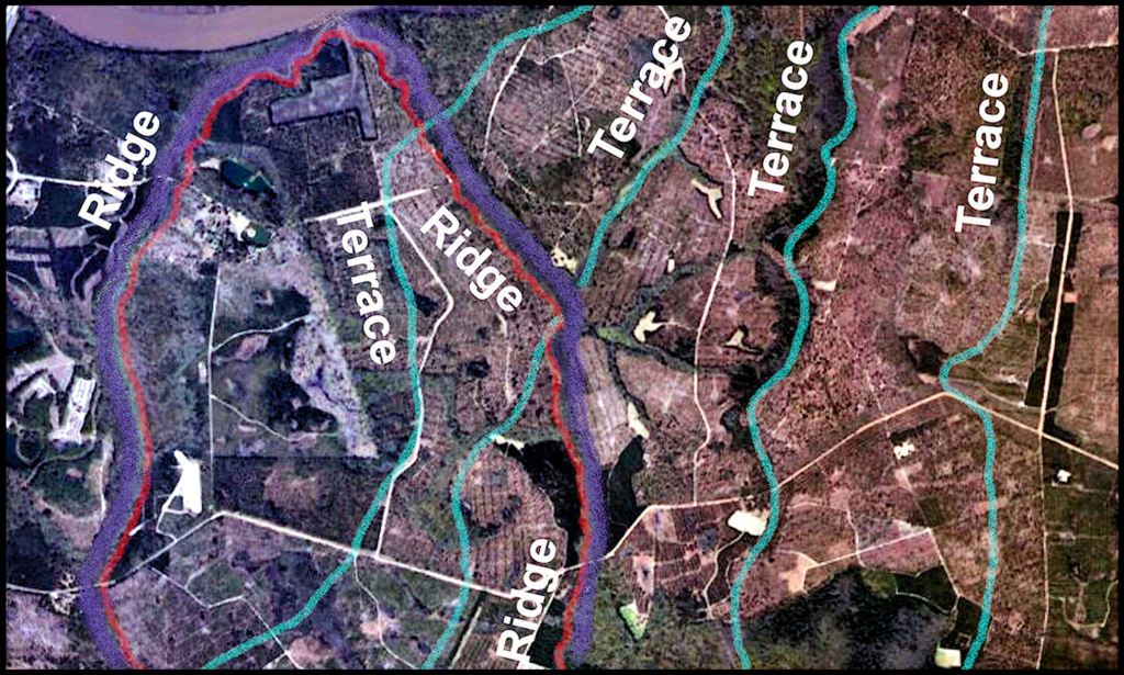
Richard what is the hexagonal shaper dark soil in the kelly picture? Don McMahon ________________________________
LikeLike
It was really not a hexagon, but asymmetrical in shape. The dark material in the soil marks the location of several huts, one built on the site of another.
LikeLiked by 1 person