The Tennessee River had a pure Maya name until 1789. The Holston River had a pure Peruvian name until 1764. The State of Tennessee has erased the Chickasaw.
The Origins of the Chickasaw and Creek Peoples – Part 12
by Richard L. Thornton, Architect and City Planner
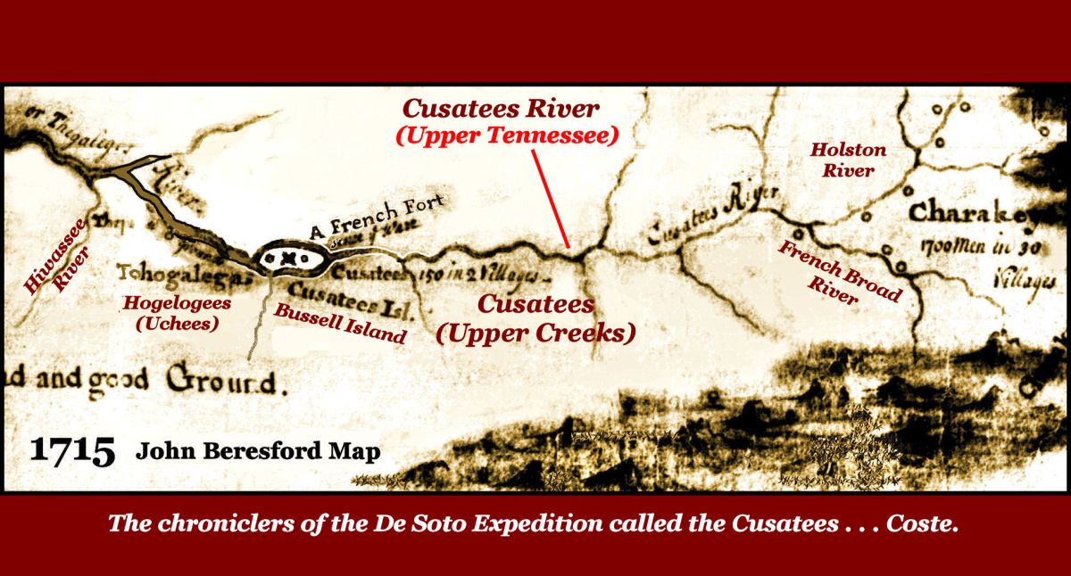
Map Above: The Beresford Map was drawn in 1715 by John and Richard Beresford, officers of the Carolina Militia, at the onset of the Yamasee War. Initially, all the major tribes north of Florida and south of the Ohio (including the Cherokees) declared war on the Province of Carolina. There was no North and South Carolina at that time. The purpose of the map was to enumerate how many Native American warriors would be fighting British forces and their precise location. This map showed garrisoned French forts on the Tennessee River in Tennessee and the Coosa River in SE Alabama. However, all published and internet references other than “The Americas Revealed” do not mention the larger Tennessee fort and state that Fort Toulouse in Alabama was built in 1717, This is obviously not the case, if the British military knew the fort’s specific location in 1715.
The French Fort on Bussell Island, where the Tennessee and Little Tennessee Rivers join, was actually excavated by two Smithsonian Institute archaeologists in the mid-1880s. Even though the large, sawn log fort had blockhouse towers on its corners and contained a strata, thickly populated by European domestic artifacts, such as chinaware and kitchen utensils, they interpreted it as a “fortified Cherokee village.” There is no known Cherokee village with a log palisade around it. Their findings were published by the Smithsonian, but not considered when TVA archaeologists briefly worked on the site during the late 1930s.

Official Tennessee history is somewhat better
The new Official Tennessee State History textbook is a vast improvement over the one being used in 2006, when the People of One Fire was founded. The former book didn’t mention the Chickasaw or the Uchee, who occupied about 75% of the future state for many centuries. The former book falsely stated that Cherokees greeted Spanish explorers such as Hernando de Soto and Juan Pardo. The former book barely mentioned the hundreds of mounds built by ancestors of the Creek and Chickasaw Indians and even incorrectly gave credit to the Cherokees for building the mounds in eastern Tennessee.
However, as seen in the map above, the new book still has some glaring errors. Take a look at this passage from the new textbook, which you can also read on line.
“Some of the indigenous or native peoples, such as the Yuchi, remained, but they were driven out in the early eighteenth century by the Cherokee, who apparently migrated into the region after it was emptied by disease. There is evidence of a large-scale massacre at the Yuchi town of Chestowee in 1714. Cherokee hostility probably caused the Yuchi to abandon eastern Tennessee and settle further south in Georgia. The Yuchi people were one of the early tribes of eastern Tennessee. “Tanasi,” which gave its name to the state, may have originally been a Yuchi word.”
The authors intentionally left out the names of other major Native American tribes! The Chickasaw occupied most of Tennessee for at least a thousand years!
The book falsely state that no other tribes lived in Tennessee after around 1714. The Chickasaw once occupied most of Tennessee and were living in western Tennessee until 1818. The Upper Creeks lived in Eastern Tennessee until 1795! There were Uchees living in the mountains of extreme SE Tennessee until the early 1920s, when their land was acquired by the US Forest Service.
The textbook still uses an alternate spelling of Uchee that originated on the Tennessee Frontier and places their homeland in Tennessee. When Georgia was founded in 1733, Uchee territory in Georgia was significantly larger than the real territory of the Cherokees. The Uchee Migration Legend says that they migrated across the Atlantic Ocean and first settled at the mouth of the Savannah River.
In 2006 and 2007 Cherokee officials and professors from North Carolina drove down to Etowah Mounds in Cartersville, GA and demanded that all references to the Creek Indians be removed from the museum. Georgia officials refused the demand, but as a compromise uninvited a group of top Oklahoma Creek officials to be speakers at the annual Barbicoa Dinner and replaced them with Cherokee officials. This occurred two weeks before the event!
Apparently, Tennessee academicians realized that they would have to stop saying that the Cherokee were living in Tennessee in the 1500s, because it grossly conflicted with the archaeological record. However, in order to avoid offending the Cherokee, they left out the names of all indigenous tribes of Tennessee.
Note on the map above that two years AFTER the Uchee were supposedly massacred in Tennessee, they were still living on the Tennessee within French-protected territory . . . just downstream from a French fort and Upper Creek villages. All of the upper Tennessee River was Creek territory. Cherokee villages were limited to the Holston and lower French Broad Rivers. The actual Uchee village massacred was in Georgia on the west side of the Hiwassee River. The survivors of Choestoe then moved a few miles southward to the headwaters of the Nottely River, where the Choestoe Community is located today.
Tennessee school children are still being taught lies and an incomplete history.
Meaning of the word Tennessee
Tennessee is the Anglicization of the Cherokee-nization of the Creek word Taeno-si. The name originally applied to one town on the lower end of the Little Tennessee River, which was occupied by Taino Arawaks. Until 1789, the Little Tennessee River in Georgia, North Carolina and Tennessee was called the Tanosi River. The lower section of the Little Tennessee River was called the Tellico River by the Cherokee.
The Upper Tennessee River was then called the Cusate or Hogeloge River. The remainder of the Tennessee River was called the Callemako River (see below). When the Tennessee Territory was created in 1789, lawmakers used the frontier English pronunciation of the Creek word Taenosi as the name of the main river and the territory. The Saticoa River, which flows into the Little Tennessee River near the Cherokee village of Tellico, was renamed the Tellico River.

Meaning of old names for Callemako River and Chickamauga Creek
Callemako is a Yucateca Maya word that means “House of the King.”
Chickamauga is the Anglicization of the Cherokee-nization of the Itza Maya word, Chiki Mako, which means house of the king.
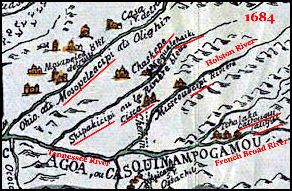
Original name for the Holston River
As seen on the 1684 French map, the original name of the Holston River was the Shipaki-sipi. This is a Panoan-Southern Arawak word from eastern Peru, which means “Shipa People River.” The Shipi or Shipibo were and are a large tribe in eastern Peru and the western edge of the Amazon River Basin in Brazil. Shipi actually means “monkey.”

Richard, This is getting into my home territory now and I’m trying to get oriented to the 1755 map. The word Pellisippi is prominent here, so I’m wondering if the river marked Pelisipi is our beautiful Clinch River which flows into the Tennessee west of Knoxville.
LikeLiked by 2 people
Yes, it is. Pelisipi is a Peruvian word – sipi means river.
LikeLiked by 3 people