
Origins of the Chickasaws and Creeks – Part 15
by Richard L. Thornton, Architect and City Planner

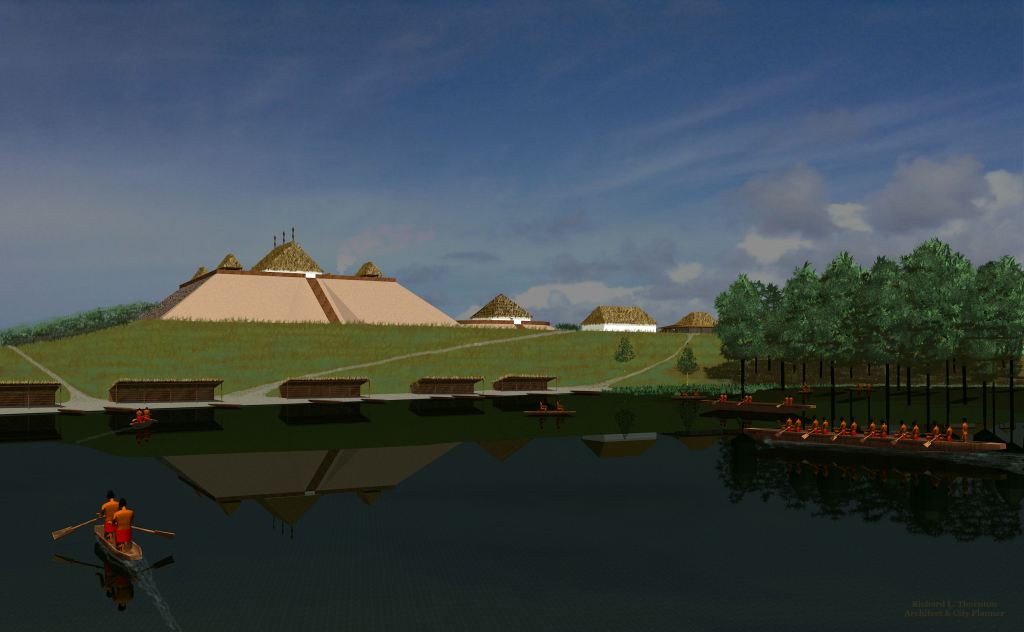
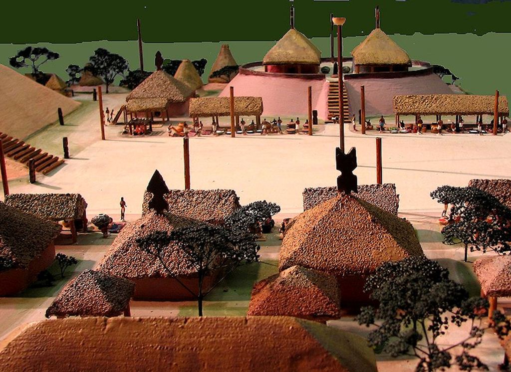
In the 1930s Dr. Arthur Kelly determined that the initial occupation of the Ocmulgee acropolis was defined by asymmetrical clusters of 35 feet (10.7 m), teepee like houses, which are typical of northern South America – but Kelly did not realize that. Kelly did not know anything about South American indigenous architecture and radiocarbon dating had not been invented. He interpreted them as oversized Caddo houses, which were typically about 12 feet in diameter. Nevertheless, this archaeological fact was recorded in the project’s journal, but was concealed by the Midwestern archaeologists, who in the late 1940s and early 1950s planned the Ocmulgee Museum and wrote its original guidebook.
The presence of the large round houses at the bottom level of Ocmulgee’s acropolis was confirmed by a remote sensing project in 2012. This is highly significant. In recent years, I have discovered that most of the cultural traditions that define the Creek Indians from other North American tribes originated in eastern Peru. These include several basic words in the Creek languages, the Creek Square, the Stomp Dance, traditional Creek clothing and head attire, plus the consumption of tea, brewed from the yaupon holly . . . aka the Sacred Black Drink.
Archaeological surveys on the west side of the Ocmulgee River and in the Bond Swamp in the southern part of the Ocmulgee National Historic Park, since 2012, have also radically changed the understanding of indigenous occupation of the region. What is now Downtown Macon, once contained several large towns that were occupied in the Woodland Period and continued to be occupied after construction began on the Acropolis. Occupation continued at many locations on the west side of the river and Lamar Village on the east side until the mid-1700s. Some large town sites, such as at Amerson Park and Riverside Park continued until 1814.

The Bond Swamp, south of the Acropolis and immediately north of Brown’s Mount, was a district of very intensive agricultural activity, with farmsteads scattered throughout. Its intensive occupation seems to have coincided with the development of the Acropolis. However, indigenous humans continued to live and farm there until the early 1800s.
The Ocmulgee Acropolis apparently began as a vacant tract of land on the periphery of a cluster of towns, which was assigned to new immigrants from the south. It is now known that rather than being a short-lived, “out parcel” of advanced indigenous culture in the middle of nowhere, as defined by many books published by Midwestern archaeologists, Ocmulgee was a massive megapolis, stretching about 46 miles along the Ocmulgee River. It contained many ethnic groups, whose languages and customs blended. It was indeed, the Mother Town of advanced indigenous culture in Eastern North America.

Daniel Bigman’s dissertation
In 2012, while I was shaking up the anthropological apple cart with research reports on my Itza Maya ancestors, Dr. Daniel Bigman, was making extraordinary discoveries at what was then Ocmulgee National Monument. Using remote sensing technology, he surveyed the acropolis of Ocmulgee as part of his research for his dissertation. That research provides a radical new understanding of Ocmulgee’s architectural history that still is not reflected in the exhibits at Ocmulgee or the professional literature.
It is unfortunate that I was not on his dissertation committee, because the University of Georgia faculty members, who were, obviously were not familiar with the powerful tools that remote sensing technologies have become for archaeologists, working in Mesoamerica or South America. Actually, they also have become important tools for land surveyors, historic preservation architects and civil engineers.
Rather than completing his array of remote sensing tools with a LIDAR scan, Bigman was required to enumerate 75-80 year-old boxes of potsherds, vaguely assigned to various sections of the Ocmulgee archaeological dig. Under these conditions, it was impossible for Bigman to carry out any real scientific examination of the potsherds that might affect his primary focus – architecture and site planning. There was no information as to where exactly – in terms of depth and x-y coordinates – the pottery was found!
Like Dr. Kelly, seven decades earlier, the dissertation committee was unaware that the large circular houses were indigenous to northern South America. Yes, these houses were also built by the people in the Florida Panhandle that the Spanish incorrectly labeled “Apalache.” However, Florida anthropologists have never bothered to translate the recorded names of the Apalache villages. They are Southern Arawak words from Peru!
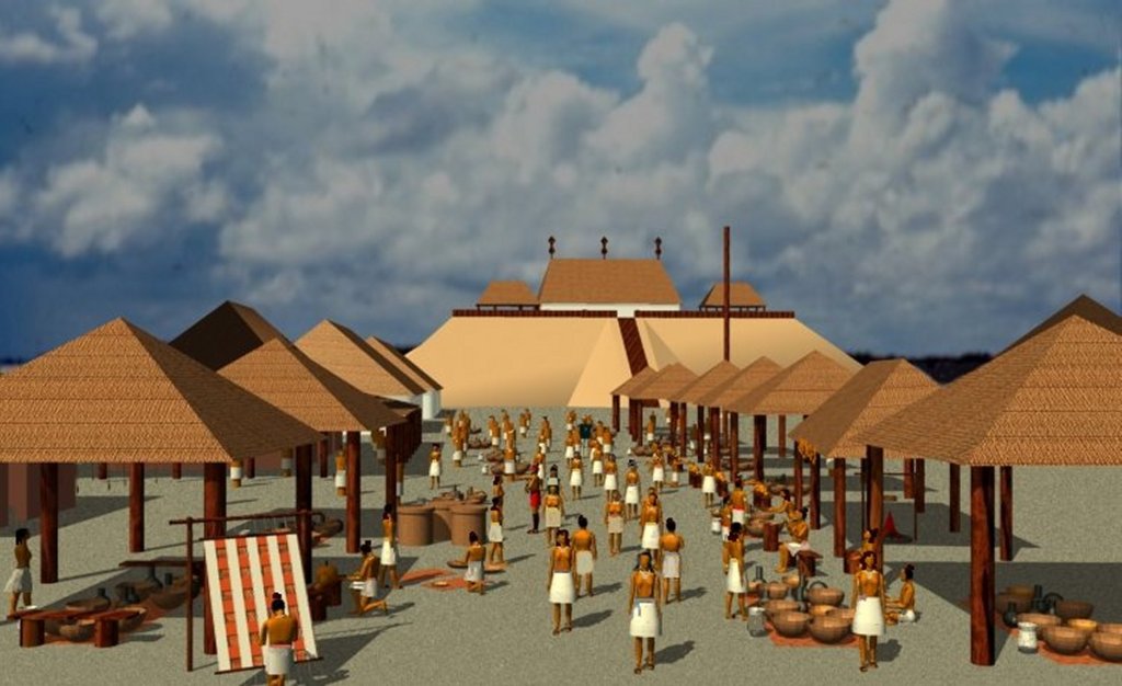
Bigman was allowed to carry out radiocarbon dating of the house footprints. The house footprints contained a significant percentage of ashes and charcoal in the vicinity of hearths. The earliest houses dated from the late 800s AD. Round houses continued to be the only architectural style on the acropolis until around 1000 AD or slightly later. Then large square houses, about 30-35 feet on a side, began to appear. At the same time, the acropolis plan changed from a random arrangement of clustered round houses to a formal arrangement with a rectangular plaza . . . a Mesoamerican planning tradition.
By about 1100 AD, all houses on the acropolis were square. However, in some suburban neighborhoods, round houses of about 15-20 feet diameter continued to be constructed. These neighborhoods originally produced Swift Creek style pottery, but by the end of the acropolis occupation, stamped pottery was rare.
Large, square houses were not typical of most branches of the Mayas. Typical Maya and Totonac houses were rectangular with a side wall t0 end wall ration of about 3:1. Large, square houses were typical of wealthy Chontal Maya merchants of the Gulf Coast, plus the Zoque (Sokee) and other former participants in the Olmec Civilization of western Tabasco, northern Chiapas and southern Veracruz. In our first orientation meeting, Dr. Román Piña-Chan, Curator of the Museo Nacional de Antropologia de México, stated that the only cultures with copper-working skills approaching those of the Indians of Georgia, lived in the mountains of the southern tip of Veracruz, NE Oaxaca and NW Chiapas. This, of course, is where many branches of the Creek Indians came from.
Mixing of peoples results in blended cultural memories
During this era, Panoans from Peru established the boundaries of what 1200 years later would be called the “Creek Indians.” The ancestors of the Chickasaw spread eastward until they reached the Savannah River . . . thus depositing a cultural memory in the future hybrid people that would be called Creeks of an eastward journey from the Mississippi River, which most of their ancestors never took. Meanwhile, the Arawaks in the North Carolina Mountains absorbed cultural influences from the Hopewell Culture, but soon would be influenced by the arrival of Shawnee from the north and Itza Mayas from the south.
From the early 1800s onward, both historians and frontiersmen in the Southeastern United States had an astonishing misperception. They assumed that all of the Southeastern tribes, except those exterminated by the Spanish in Florida and Coastal Georgia, had been living in the same place for hundreds or thousands of years. The real story is one of peoples from many different places constantly mixing then bands constantly breaking off and forming new tribes.
When tribes stated that they did not know who built the abandoned mounds near their villages, it was popularly believed that white men had built them. The truth is that they had moved to the location after the mound builders had moved somewhere else. Particularly in Georgia and Alabama, the majority of the new white settlers were from the Carolinas and Virginia. They had little direct knowledge of the Native peoples, who had lived there before them. These settlers made up fanciful stories to explain indigenous place names and long abandoned mounds. Their descendants in the Southern Highlands have made these myths into a religion. Far too often, archaeologists took these myths as the basis for interpreting their digs.
In the late 20th century, archaeologists in the United States recognized that the vast quantities of attapulgite and mica used by the Teotihuacano, Totonac and Maya civilizations far exceeded the available deposits in Mexico. They therefore adopted as a semi-fact that these minerals came from over 5,000 miles away in eastern Brazil. Georgia’s mica and attapulgite deposits are a fifth of the distance and directly adjacent to the Chattahoochee River. Both minerals are far more abundant in Georgia than in Brazil, but to admit Pre-Columbian trade between Mexico and the Southeastern United States would force the Gringos to admit that there were close encounters of a third kind between the Southeastern Indians, Mesoamerica, the Caribbean Basin and South America. That would have been a fate far worse than death.
The most accurate understanding of the cultural history of the Lower Southeast, before the 21st century, can be found in its first anthropologist, Charles C. Jones, Jr. He was an attorney and later mayor in Savannah, but his ancestors had deep Colonial Era roots in Liberty County, Georgia. He knew that the Creeks, Chickasaws and Uchees had once occupied all of Georgia and most of Alabama. His ancestors also considered the Creeks to be a civilized people.
Therefore, Jones assumed that all mounds in the state, including areas most recently occupied by the Cherokees had been built by the ancestors of the Creeks. Jone’s undergraduate degree in history was from Princeton, while his law degree was from Harvard. However, contemporary archaeologists label him an “amateur,” while the self-styled archaeologists, who followed him, had less education and no college credentials in history, anthropology, archaeology or ethnology.
Ten years after Jones wrote his landmark book on the Southeastern Indians in 1873, the Smithsonian Institute sent a team of self-styled archeologists with no professional credentials to the Lower Southeast to excavate its mounds. In most cases, the actual supervisors of these digs had no advanced education and no special skills, but were hired because they were Union Veterans.
The Smithsonian employees ignored maps of Georgia before the American Revolution and Jones’ books. In the process they created many of the ethnological and historical myths that now appear on state historical markers in that region of the country. A consistent trait from 1883 until the 1980s was that they believed that the Indian Tribes had always lived where they were living at the close of the American Revolution.
Anthropologists and botanists long assumed that about 1500 years ago, maize kernels miraculously jumped from Central Mexico to Cahokia, Illinois then were carried by Northern missionaries to the ignorant savages of the Southeast. However, it is now known that maize (Indian corn) was being grown on raised beds at Fort Center near Lake Okeechobee, FL by 800 BC and 3200-year-old maize pollen has been found in southeastern Alabama.
The biggest surprise occurred in 2017, geneticists discovered that Indian corn, grown in the eastern 2/3 of the United States and all modern hybrid varieties in the United States are descended from a hybrid maize developed in the eastern foothills of the Andes in South America . . . not Central Mexico! This is the exact same origin where the Panoan Peoples live until this day. They include the Conibo, Shipibo, Kaushibo and Chiska Peoples.
Evolving understanding of the Swift Creek Culture
While he was in charge of the federally-funded archaeological digs in Georgia, Dr. Arthur Kelly believed that the Swift Creek peoples were Caddo immigrants from Texas, his home states. From the early 1950s to the late 1960s, visitors to Ocmulgee National Monument were told that the Swift Creek People immigrated to central Georgia from New England. There is nothing in New England, which resembles the Swift Creek Culture.
By 1950, Arthur Kelly theorized that the culture initially believed that the Swift Creek People came from Florida, but in 1959 he found the oldest known Swift Creek pottery at the Mandeville Site on the Lower Chattahoochee River just above where it is joined by the Flint River. It was dated to around 100 AD and was more sophisticated than later Swift Creek pottery. Initially, Swift Creek style represented about 1% of the pottery produced at Mandeville, but within a century characterized almost all the pottery at Mandeville. The Swift Creek Culture was well established in Georgia before it was being made in Florida.
During the past 80 years, none of the experts on the Swift Creek Culture and Swift Creek pottery have noticed a very significant fact. To this day the patterns and motifs of the clothing worn by the Conibo People of Satipo Province, Peru contain designs, identical to the motifs on Swift Creek pottery. There is a connection.
The Creeks and the Panoans of Satipo Province, Peru use the same words for yaupon holly/Black Drink (ase), canoe (pira), village chief (orata), priest (joana), sweet potato (aho), beans (talako), tobacco (heche), pumpkin (chasi) and High King (paracusa). Some future members of the Creek Confederacy also used the Panoan word for a provincial king (uriwa), but most used the Itza word for that position. There are probably many other words that we have not had time to identify.
The Florida Apalachee
The Weeden Island Culture (200 AD-900 AD in Florida ~ 350 AD-750 AD in SW Georgia) – First near the Gulf Coast above Tampa Bay then in the eastern part of the Florida Panhandle then in extreme Southwest Georgia and Southeast Alabama, a distinctive ceramics style appeared in towns that were making Swift Creek style pottery. It strongly resembled the ceramics in the coastal regions of present-day Colombia and Venezuela. The territory eventually occupied by the Weeden Island Culture exactly matched the territory occupied by the Apalachee, when they were first contacted by Spanish officials in St. Augustine. It extended up the Chattahoochee River to just south of the Mandeville town site.
As a college student and young professional, I assumed that everything that Florida anthropology professors said about the Florida Apalachee was accurate. They were supposedly Muskogeans and spoke an extinct language that was labeled “Southern Muskogean.” Unlike most branches of the Creeks, the Apalachee were polytheistic and worshiped a pantheon of deities.
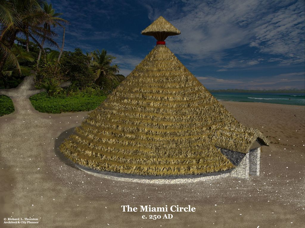
Even then, one thing bothered me. The Apalachee houses were large cone shaped structures for extended families. The Apalachee communal structures were rectangular. That was just the opposite of the architecture of other Muskogean peoples. The Chickasaw council houses were square, not rectangular, but their houses were identical to the Maya houses in Campeche. Of course, just as the members of the Society for Georgia Archaeology were fond of saying in 2012 . . . I was just an architect.
Marilyn Rae’s discovery of Charles de Rochefort’s book in the Brown University Library, completely changed my perception of the Southeast’s past. In fact, his eyewitness description of Proto-Creek culture in present day Georgia was so radically different than what was said in archaeology books, I initially assumed it to be mostly fiction. However, his detailed and accurate descriptions of 17th century Creek houses, fortifications and public buildings convinced me to fact-check him. Much of the information he wrote was not known to archaeologists until the latter half of the 20th century. However, one by one, every detail of De Rochefort’s descriptions checked out.
Keep in mind that this book was written in 1658! De Rochefort stated that Apalache was not the real name of the people in Florida, who the Spanish had named Apalache. One of the first villages, which Hernando de Soto visited in northwest Florida was named Apalachen, which is the plural of Apalache. He said that the commoners of this province had arrived in Florida from the south several centuries before Apalache established colonies there. A queen of the Apalache directed the construction of the Great White Path (road) through the colony, which connected the Tallasee (Little Tennessee) River with the Gulf of Mexico. This road is now the route of US Highway 129.

The real Apalache colonists established a colony next to a large lake in the Florida Panhandle. The colonists called themselves Talahalwasee, which means “Colony of the Highland Towns.” This is the origin of the name of Tallahassee, Florida . . . not the Muskogee words for “Old Town.” De Rochefort went on to say that over time, the true Apalache intermarried so much with the commoners that their hybrid language became unintelligible to the Highland Apalache. However, the two peoples remained on friendly terms and traded often.
Apalache Creeks would have had no trouble understanding the languages spoken at the San Luis de Talimale and San Martin de Tomale. Those were Itsate Creek newcomers from Southeast Georgia, who had converted to Catholicism.
So, what language did the commoners speak in the Florida Panhandle? The principal town of the “Florida Apalachee” when De Soto stayed there was named Anihaica. That is definitely not a Muskogean word. It also was not a Middle Arawak or “Timucua” word. However, in a Ashininka-Southern Arawak Dictionary from Peru, it translates as “Elite-Place of.” Bingo!
DNA confirms Southern Arawak roots
Towns County is located on the northern edge of Northeast Georgia. The Hiwassee River begins at its southern edge, just across Unicoi Gap from the origin of the Chattahoochee River. The river flows northwestward across the county until it flows into North Carolina near Brasstown, NC.
I first became aware of a distinct Indian tribe, unknown to academicians, in Towns County in June 2010. After being constantly harassed in western North Carolina by a wacko US Forest Service Law Enforcement Officer from Florida, I fled across the state line into Towns County, GA. The USFS LEO wore a cowboy hat and cowboy hat. He liked to drive around the mountains with teenage boys in the front seat of his SUV. He was also good friends with the High Priestess of a witch cult that had recently moved to the Murphy, NC area from California. (Yes, really!)
Just before closing time, I stopped by a supermarket in Hiawassee to stock up with food for my campsite near Brasstown Bald Mountain. The two young women at the only open check out counter looked like Florida Seminoles. I assumed that their families had a summer cabin nearby. As it came my turn at the cash register, I remarked, “Bet you two love getting out of that South Florida heat and humidity.” They looked confused and responded, “We live here all the time.”
Here is a summary of our conversation. Their people had lived in the Upper Hiwassee River Valley for many centuries before the Cherokees arrived and stole their best farm lands. Their real name was the Hiwassee, but most folks now called them the Towns County Indians. When I told them that Hiawassee is the Creek word for “Highlanders,” they responded that it made sense. They had often wondered who they really were, but seemed to have a lot in common with the Creeks.
Both young women emphasized that they were not Cherokees, but some of their people had been put on the rolls of the Eastern Band of Cherokee Indians. One gal mentioned that her brother had been formerly married to a North Carolina Cherokee. She did not get along with their family at all. She was constantly going into rages, when she didn’t get her way. He finally divorced her and moved to Atlanta. He is now married to a lady from Louisiana, who was a member of some tribe there. Everybody in their family really likes her.
The gals said that the soldiers captured some of their people during the Trail of Tears roundup, but since they were not Cherokees and lived outside the boundaries of the Cherokee Nation, their names were not on the “pickup list.” Most of their people were able to hide out in the mountains north of the Nacoochee Valley in Georgia. The soldiers hired the famous Cherokee leader, Junaluska to lead a band of Cherokee men to capture them, but Georgia whites would let the heavily armed Cherokee bounty hunters cross the state line.*
*Did you know that it was a firing squad of Junaluska’s bounty hunters, who actually executed “Tsali” – the famous “Cherokee” hero. The version of his life as portrayed in the Cherokee outdoor drama, “Unto These Hills” is mostly fiction. His real name was Tchali Uchee. He was a Creek-and-English-speaking Uchee Indian and citizen of the State of Georgia, living far outside the Cherokee Nation. His farmstead was in the Dillard Valley on Bettys Creek near where Rabun Gap-Nacoochee School is now located. He was angry because the soldiers were forcing his family on the Cherokee Removal, when in fact, his family should have not been disturbed. However, the soldiers didn’t believe his English protests and assumed him to be Cherokee, because he looked like an Indian.
Nowhere, have I been able to find a discussion of the Town County Indians in anthropological texts or Georgia history books, but they really exist and are eligible for federal recognition as a separate tribe. Their DNA is proof that Hiawassee Indians are a distinct indigenous ethnic group.
You see . . . in 2012 and 2013, several Towns County Indians sent me emails that confirmed what the two young ladies had told me, plus they attached their DNA test reports. Several had as much as 25% Native American DNA, which is high for even “full-blooded” American Indians in the USA. None carried DNA markers typical of North American Indians. Their American Indian DNA was either a single Peruvian tribe, such as the Ashaninka, mixture of Peruvian tribes (mostly Southern Arawak and Panoan) or a mixture of Peruvian with Maya DNA markers.
It is quite probable that the Hiawassee or Towns Creek Indians are descended from the same South American people or peoples, who first lived at the Ocmulgee Acropolis. In fact, they may be the descendants of the occupants of the acropolis, who migrated northward when Mesoamerican refugees settled in and around Ocmulgee’s acropolis.
Shipibo Music and Dancing
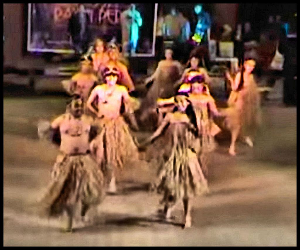
The traditional, syncopated music of the Creek People was extremely similar to that of the Shipibo, Conibo and Kaushibo Peoples of Eastern Peru. Creeks, who play boom-boom-boom music at pow-wows are practicing fake heritage.
These peoples played the same musical instruments. The men wore long shirts in cooler weather, while the women wore short skirts and traditionally went topless in the summer. They all danced the Stomp Dance and drank the Sacred Black Drink (yaupon tea). What initially struck me about this video is how closely the young women of Creek descent in eastern and central Georgia resemble these young women. This is not as much the case for Muskogee-Creek women. In fact, one of the prettiest dancers is almost identical to a mixed-heritage Creek girl from Middle Georgia, who I dated my freshman year at Georgia Tech.

It’s marvelous what is being discovered with all the new technology available. Love the dances Richard.
LikeLiked by 1 person