National Native American Heritage Month
by Richard L. Thornton, Architect and City Planner
Background
For those of you, who have not seen my videos on Mexico . . . I was the recipient of the first Barrett Fellowship from Georgia Tech. The architecture professors were quite antsy about trusting a young man, who would be turning 21, while in Mexico, to plan a complex travel study in a foreign country. They obtained the services of a travel agency that regularly handled travel for Georgia Tech administrators to plan my journey.
In my first orientation meeting with my Mexican fellowship coordinator, Dr. Román Piña-Chan, Curator of the Museo Nacional de Antropologia, it was immediately clear that he did not like the Georgia Tech faculty’s syllabus and travel itinerary. I had been booked a few package tours to major tourist attractions. For example, the Teotihuacan tour only allowed four hours at the massive metropolis, when he wanted me to spend at least five days there.
He asked me if I wanted to be a typical Gringo turisto or learn about Mexico’s Pre-Columbian heritage and how to restore ancient structures. I answered . . . “the latter.” He dumped the Tech syllabus in the trash can and asked Alejandria, one of his graduate assistants, who had graduated from a Texas university, to prepare a new syllabus.
Alejandria’s approach was to immerse me into the Mexican people via first, second and third class busses, while staying at inexpensive posadas, inns and hotels, frequented by the Mexican middle class. That worked fine until I got to Campeche. Alejandra had assumed that Campeche’s state highways were paved and that public busses passed by the majority of archaeological zones. That was not the case at all. None of the major archaeological zones in Campeche were served by public busses because the narrow dirt roads, called states highways, were extremely dangerous for large buses!

I eventually found a man in Campeche City, whose company provided logistic support for scientific and archaeological expeditions for universities . . . primarily universities in the Southeastern United States and Texas. He suggested that during the afternoon I visit to Chontal Maya village sites on the coast, which were served by Second Class busses. I was invited to evening dinner to discuss the details of my needs.

For a nominal fee, he offered to provide his daughter (a university student two weeks older than me) as a guide, plus her jeep for a week. It was going to be an ordeal for me to be her companion for for a week, but I eventually (like in about two seconds) agreed. The experience turned into an unforgettable romantic journey and I ended up spending 10 days with Ana.
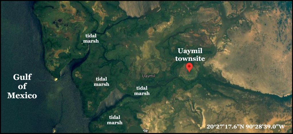
However, the entry in my journal about the two coastal sites that first afternoon was very brief. Both sites had single, modest earthen mounds, overgrown with vegetation. Neither site had been significantly studied by archaeologists. Neither site had educational signage. Pak Mul was next to a beach. Uaymil was identical to the tidal marshes along the Georgia Coast. The nature path led one from brine water tidal marshes to an island within freshwater marshes. There were some crude carved stones on the island.

Satellite imagery changes my understanding of Uaymil
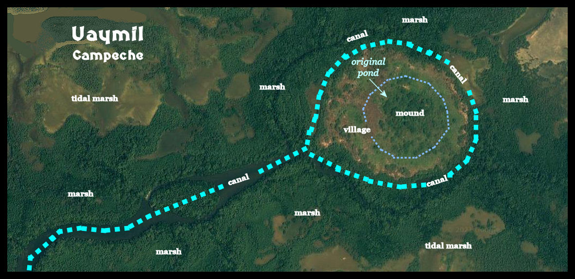
I had completely forgotten my visit to Uaymil until finally reading my Mexican journal . . . 50 years later. The site still did not seem worth mentioning until I looked at Google Maps. What I had actually visited in August 1970, was an archaeological zone quite similar to the Bilbo Mound in Savannah. Uaymil has received very little attention from archaeologists, but I was able to get some information from Spanish language articles on the web. It sounds almost identical to the archaeological description of the Bilbo Site in Savannah.
Anonymous maritime fishers-hunters-gatherers lived at this location for thousands of years. At some time before the rise of the Olmec Civilization, a mound was begun in the middle of a marsh, fed by a large, freshwater spring. It is probably one of the oldest mounds in Mexico, but no radiocarbon date was provided. A permanent village developed in and around the edge of the freshwater marsh. There was no discussion about this being a platform village, but as stated before, there has been very little archaeological excavation at the site. However, the fact that the location, just like Bilbo, is subject to high tides and flooding from storms, so it would make sense.

Eventually, the pond filled with sediment and detritus from the village. This dark sediment is still visible today on satellite imagery. Around 1400 years ago, Yokot’an Peoples (Chontal Maya) began establishing villages farther north from their original Tabasco Tidal Marshes homeland. More urbanized branches of the Maya avoided living near the ocean. Thus, there were unoccupied lands available to the Yokot’ an.
The Yokat’an excavated a broad circular canal then widened the canal to the ocean . . . creating a 15 acre village site, protected by a moat . . . which also functioned as a storm drain during hurricanes. This village developed into a major Chontal Maya seaport that served the cities within the interior. It was occupied until a smallpox plague in 1500 AD, introduced by the third Columbus voyage, wiped out most of the coastal Yokat’an population . . . including this town.

Timber pile houses on Florida’s Gulf Coast
While preparing HABS drawings (Library of Congress) for Camp Pinchot near Fort Walton Beach, Florida, I was required to show submerged mounds on the edge of Garnier Bayou. These were to be denoted on the site plan. The archaeological report for the mounds stated that the shores of Garnier and Perdido Bay was lined with mounds, which probably were not submerged during low tide, when constructed. Within the mounds were well-preserved cypress posts, which supported these houses.

