
by Richard L. Thornton, Architect and City Planner
The robust technological skills of a Historic Preservation Architect, in particular . . . infrared analysis, structural mechanics, soil mechanics and computer modeling, can be applied to ancient structures and town sites to discern extraordinary information about the past. You will be fascinated what I learned about the Nikwasi Mound and surrounding Native American town site . . . without disturbing its soil in any way.
A more detailed description of the Nikwasi Architectural Analysis will soon be posted as a video on the People of One Fire Youtube Channel.
Franklin, NC is located on the southern edge of western North Carolina along the Little Tennessee River. It is 58 miles (93.3 km) from the northern edge of the Atlanta, GA SMSA . . . 68 miles (109.4 km) from Asheville, NC and 130 miles (209 km) from Downtown Atlanta. The city was first settled in 1820.
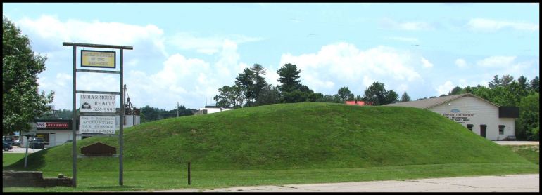
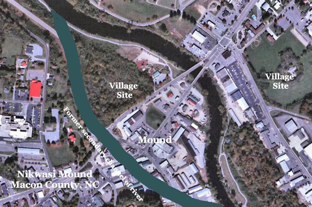
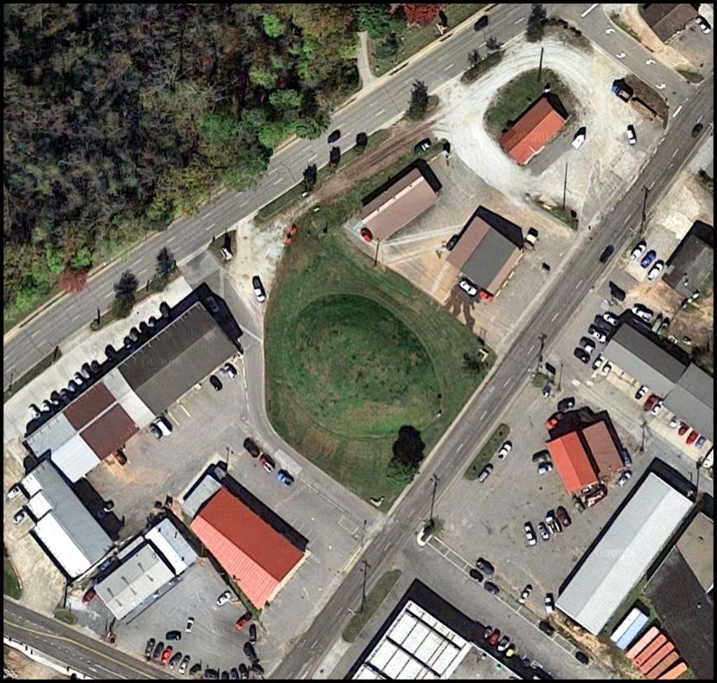
The Nikwasi Mound is located in the edge of the Franklin Central Business District and today, completely surrounded by low density urban development. From 1946 to 2019 the mound was owned by the City of Franklin. It is now owned by a non-profit foundation, The Blue Ridge Initiative.
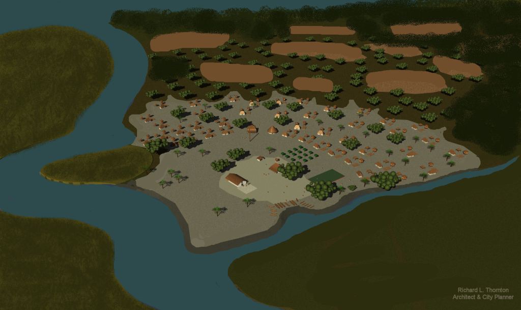
In 1776, members of the Cherokee tribe, living near the Nikwasi Mound, told explorer, William Bartram, that many peoples had constructed the Nikwasi Mound over a long period of time. The Cherokees’ statements has been confirmed by architectural analysis. At least three distinctly different forms of mounds are superimposed on each other. It is highly likely that one or more Woodland Period burial mounds are hidden beneath the mound visible today.
Etymology
Nikwasi is the Cherokee-nization of Nikase . . . the name that is used for this town in European archives until 1725. It is pronounced Nē : kä : shē. Nikase is the word for a bear cub in Eastern Creek, Itsate Creek and Apalachete Creek.
Alternative spellings of the town were Nokose and Nukose. Nokose is the Creek word for bear and is pronounced, Nō : kō : shē. Nikase also can mean a colony established by the large Creek town of Nokose (Nacoochee in English) on Dukes Creek near the Nacoochee Valley of Georgia.
Up until the creation of the Southwest Territory in 1790, the Little Tennessee River was generally known as the Tanasi River and the Tennessee River was known as the Callemaco River. Tanasi is an Anglicization of the Creek word that means “Taeno – descendants of.” Taeno meant the Taino Arawaks of Caribbean Basin, who also occupied significant areas of central and western Georgia. The Taino also occupied Jekyll Island, GA. Callemaco is the Anglicization of the Itza Maya words, Kalle-Mako, which mean “Mansion of the king.”
Individual sections of the Little Tennessee River also carried the names of the peoples living upon it. The Upper Tanasi in Georgia through the Itsate Pass was called the Itsate River. Itsate means “Itza People” in the Itza Maya language.
From present day Franklin down to the confluence with the Tuckasegee River was called the Konoste (Itsate Creek) or Konosawgi (Muskogee Creek) River. The words have the same meaning . . . Konos People. They were from the Konos Province of Peru, but became a major division of the prototypical Creek Confederacy. Tuckasegee is the Anglicization of the Muskogee Creek words, meaning “Freckled -descendants of – People.”
Below the Tuckasegee down to the confluence with what is now called the Tellico River, was called the Chiaha River. Chiaha is also Itza Maya and means “Salvia River.” According to the De Soto Chronicles, the people in that region grew massive fields of salvia along the rivers.
From the Tellico down to the confluence with the Callemaco River, the Little Tennessee was called either the Tallasee River or the Tanasi River. Talasee is the Anglicization of the Itsate word, Tulasi, which means “colony of Etula (Etowah Mounds.)

Analytical Methodology
Infrared image analysis is a powerful tool for historic preservation architects. I was one of the pioneers in the non-military use of infrared imagery during the late 1980s . . . with the extensive assistance of the National Park Service archaeologists from the NPS Harpers Ferry Center, who were working at my Shenandoah Valley farm. They were able to obtain a military quality, high resolution, infrared satellite image of my farm in an era, when such things were not available to the general public.
There is a distinctive difference between military and archaeological uses of infrared technology. In military uses, one is looking for objects that are generating infrared energy . . . typically humans or machinery. However, historic preservation architects are looking for differences in the way inanimate objects ABSORB infrared energy. On old farms and Native American town sites, I look for decayed wood/vegetative matter, decomposed human/animal remains, decomposed fecal matter and the general detritus of human occupation.
Stone shows up on these USGS images as a substance that absorbs less infrared energy. That is useful, though. Outbuildings on my farm, which were burned during the Battle of Toms Brook (Oct. 9, 1864) showed up as lightly tinted fieldstone islands in a sea of black charcoal.
There are numerous frequencies or spectrums of infrared energy. Each has its own analytical characteristics, which are especially important to intelligence analysts. Thus, a device used for detecting human intruders or wildlife might not be the best device for finding the footprint of a thousand-year-old house.
As I began applying my new technology to the restoration of other Colonial and Federal Period farms in northern Virginia, I found that Near Visible Light Infrared Images were the most successful in capturing the footprints of ancient structures in pastures or lawns. The reason is that this spectrum also detects the color of the grass. A concentration of decomposed organic matter around an ancient Native American house or farm building will make the grass greener.
- After receiving special training by the National Park Service in the history and preservation of earthen fortifications in 1996, I began applying infrared technology to the detection of lost fortifications.
- In 2003, I began applying the experiences, learned with Civil War earthworks, to the detection and analysis of Native American earthworks. This was done in conjunction with the application of French virtual reality software to the study and modeling of Native American architecture.
- At the time, this was a revolutionary idea, which resulted in a program about my work on the Architecture Channel in the United Kingdom.
- In 2006, I used infrared imagery, provided by the USGS in Reston, VA to create a plan of the town of Etula (Etowah Mounds) around 1375 AD then build a 6 feet by 8 feet model of the town, which is now on display in the Muscogee Creek Capitol, under the Great Seal of the tribe. In the process of analyzing the soils and topography, I realized that until around 1200 AD, the Etowah River flowed around the north side of the town . . . where the museum is now. Archaeologists missed this important information. It radically changes our understanding of the town sites.
- In 2008, I used infrared imagery to create site plans and architecture drawings of Mission Santa Catalina de Guale on St. Catherines Island. My client was the American Museum of Natural History in NYC. The part of the assignment involving re-creation of the Guale town site prior to the mission, would have been impossible without infrared imagery.
- Currently, I am using infrared and LIDAR to relocate over 130 stone and earthen structures that were first discovered either by Smithsonian archaeologists Cyrus Thomas in 1886 or WPA archaeologist, Robert Wauchope, in 1939. Both men provided very vague descriptions of the site locations.

Introduction to the Nikwasi or Noquisi Mound
Always considered an important landmark in western North Carolina, the Nikwasi Mound is an ideal candidate for infrared analysis, since it has never been excavated by professional archaeologists, only amateur artifact collectors. In my analysis of the earthen structure, I also utilized visible light satellite imagery, image enhancing software, a laser measuring device, a 3D compass and a magnetometer.
A 1937 survey of the mound at Nikwasi measured its dimensions as 30 meters wide ( 98.5 ft) and 50 meters ( 164 feet) long and six meters (19.75 ft.) tall. It has slightly decreased in height since then. In the early 1700s, it was probably around 7.6 meters (25 ft) tall. Due to erosion, the Nikwasi Mound is currently about 4.6 meters (15 ft) tall.
In 1776, a Wataree (Watagi (Cherokee) ~ Watauga (Tennessee) chief, living in Cowee, slightly north of present-day Franklin, told explorer William Bartram that many peoples at lived at the site of the Nikwasi Mound. Each had added onto the mound and even changed its shape. That is important information, which conflicts with the current claim by some North Carolina archaeologists that the Cherokee have lived at the mound site, since the arrival of humans in the Americas. These academicians really, really have not done their homework! They get an F.
Historical Timeline and Analysis
1540 AD & 1567 AD – Spanish Expeditions: During 2010, while I was living in a tent in western North Carolina, former National Park Service Director, Roger Kennedy, funded my intensive search for the real routes, used by Hernando de Soto and Juan Pardo. During the 1980s, several of the professors, involved with the search for the route of De Soto, came to my office in Asheville City Hall, armed with North Carolina highway maps, adorned with masking tape to show the routes of De Soto and Pardo.
In addition to foolishly assuming that the two expeditions took the same routes, they assumed that Guaxule was a three feet high mound in a cow pasture on the Biltmore Estate. Two state archaeologists told them that their site was Woodland Period and that there were no Mississippian towns in the French Broad River Valley during the mid-1500s. They ignored us . . . gave a press conference stating that De Soto came through Asheville and picked up large checks from the Chamber of Commerce and the Biltmore Estate. An Appalachian State University archaeological dig in 2000-2001 proved us right, but the fake route for De Soto is still in Wikipedia.
After camping and hoofing it all over western North Carolina, I am convinced that both De Soto and Pardo came past the Nikwasi Mound, but they arrived on entirely different trails, plus were going in different directions.
1653 – Richard Brigstock: Richard Brigstock, a Barbados planter, was the guest of the High King of Apalache during most of 1653. The capitol was in the Nacoochee Valley. Some men, working at the new Spanish trading post, located where the pasture for Chattahoochee Stables in Sautee now is, suggested that he might enjoy seeing some gem miners. He traveled for three days in a northerly direction to a river that flowed northward. Franklin is 50 miles ( 80.5 km) north of the Nacoochee Valley.
Brigstock found numerous Spanish-speaking and Apalachete (Creek) gem miners working the river and streams and indeed, finding valuable gems. This certainly does sound like the Franklin, NC area. There were also some Spanish-speaking gold miners near the capital. The Spanish-speaking men were friendly with Brigstock. By then, Brigstock was able to at least communicate with the Apalachete men. There were no other Indian tribes in the region. In other words, there were no Cherokees.
1700 – Guillaume De L’Isle Map of Louisiana and La Florida: This map shows specific names of towns and tribes along the Little Tennessee River. Most of the towns are Creek tribal names. However, western North Carolina as a whole is labeled, Pays de Chouenon (Land of the Shawnee). There is no word similar to Cherokee on the map.
1715 – John & Richard Beresford Map: This is the first map of Southeastern North America that mentions the Cherokees. They are shown to be living in extreme northeastern Tennessee and along the headwaters tributaries of the Savannah River. They are not shown to be in North Carolina.
1721 – Francis Varnod Census: This census enumerated in 1721 as part of a survey of Cherokee towns for the Anglican Society for Propagation of the Gospel, found the native population of Nikwasi to be 142 . . . 53 men, 50 women, and 59 children. Nikwasi was hardly the “Great Mother Town” of the Cherokees as recent websites state. It was a small village, during Cherokee times . . . at best.
1721 – John Barnwell Map: Nagoosee (NC) is on the map, but Noogochee (GA) is not!
1725 – John Herbert Map: Noogoochee (Georgia) is shown on the map. There is no village in North Carolina named Nocoochee, Nikwasee, Noogoochee or any similar word.
1727 – John Herbert Treaty Conference: (p. 13) “We went Over to Nequisey; to meet the head men in order to talk with: them Out of the following Towns were head men at the meeting. . . I told them that I was sorry that there was so few men at the meeting to hear the English talk but that I was sensible of the reason of it, there people being out a hunting & that I should have expected more of them had they not been out a hunting.”
1730 – Arthur Cuming Conference: Following the Cherokee signing of the treaty with South Carolina, a self-appointed royal ambassador, Alexander Cuming, was hosted at the town from April 3 to 4, 1730. During the negotiations with the Cherokee, Cuming had met with Uku (or “First Beloved Man”) Moytoy (known also as Ama-edohi).Cuming “appointed” Moytoy as “Emperor” of the Cherokee and secured a dubious pledge of allegiance of all the Cherokee peoples to King George II from him. It was dubious because each local division of the Cherokee Alliance acted independently and was not bound by the decisions of the “emperor.”
1755 – John Mitchell Map: This map spells the village’s name as Naquaisee. It also confirms that in the autumn of 1754, an army dispatched solely by the Coweta Creeks, captured and burned most of the Lower Cherokee villages in lands the Creeks occupied prior to 1716 and executed 32 Cherokee chiefs in revenge for 32 Creek leaders being murdered in their sleep at the Tugaloo Conference in December 1715. This forced the Cherokees to sign a surrender treaty in December 1754, ending the 40 year long Creek-Cherokee War. The Mitchell map shows that Nikwasi was not burned by the Coweta Creeks.
1761 – Anglo-Cherokee War: During the summer of 1761, the Nikwasi townhouse was used as a field hospital by members of a punitive English expedition against the Cherokee. The village was burned by the British soldiers, but later rebuilt.
1776 – American Revolution: During the Rutherford Light Horse expedition, rebel forces burned the the village on September 10, 1776 in retaliation for bloody raids on the South Carolina frontier. The village was rebuilt again.
1818 – Land cessions: The Cherokees and Creeks ceded all their lands in extreme northeast Georgia and in North Carolina, east of the 84th parallel. The region around the Nikwasi Mound was opened up the settlement.
In Part Two, we will first present to you, what various “Cherokee History” websites are saying about the Nikwasi Mound then fact check them. We will then show you images of Colonial Period maps that provide important information about the history of the region around Franklin, NC.

Howdy, Great article. I also use maps in my interpretation of rock finds.
On Sat, Dec 25, 2021 at 9:52 AM The Americas Revealed wrote:
> alekmountain posted: ” by Richard L. Thornton, Architect and City Planner > The robust technological skills of a Historic Preservation Architect, in > particular . . . infrared analysis, structural mechanics, soil mechanics > and computer modeling, can be applied to ancient struc” >
LikeLiked by 2 people
Hey Richard. Off topic. What do you know of the Moytoy fam? They keep showing up in peoples trees who are DNA matches to my mother. Whether or not factually accurate I do not know, but it’s prevalent. Moytoy is a curious surname and I guess anglicized.
Regards, Mau, your friend who frequents Guatemala.
Sent from my iPhone
>
LikeLiked by 2 people
Lee, I don’t know anymore about Moytoy than what one can read in Wikipedia. I have my hands full trying to figure out all these ancient stone ruins and petroglyphs in North Georgia. I do warn people, who think that they are Cherokee descendants that Cherokee women could have several husbands in one year. Lt. Henry Timberlake talked about that in his book about his time with the Overhill Cherokee. I do not think that the Cherokee genealogies on the web are very accurate. Half the state of Tennessee clamis to be descended from Moytoy and Nancy Ward. There is very little resemblance between the real life of Nancy Ward . . . who actually lived in Georgia until the late 1790s, and the one in the play named after her.
LikeLiked by 2 people
Thank you for the way this article is written. Your explanations and backstories make it understandable for those just starting to learn about this, i.e some of my children. 😆
On Sat, Dec 25, 2021, 7:52 AM The Americas Revealed wrote:
> alekmountain posted: ” by Richard L. Thornton, Architect and City Planner > The robust technological skills of a Historic Preservation Architect, in > particular . . . infrared analysis, structural mechanics, soil mechanics > and computer modeling, can be applied to ancient struc” >
LikeLiked by 1 person
Well, for most of my adult life, my primary occupation was explaining construction documents to construction workers. Quite often, that had to be done in Spanish . . . no demands for explaining in Swedish. LOL
LikeLiked by 1 person