Part Two of “Chiaha . . . an Itza Maya Province in Western North Carolina“
by Richard L. Thornton, Architect & City Planner
Despite continually advertising their PhD’s in Anthropology or History, the consortium of Southeastern academicians, who claimed to have determined the routes of these Spanish expeditions never bothered to translate the Native American words in those chronicles. This would be an unthinkable omission among Latin American and European scholars, but the consortium got away with it. In fact, the archaeology professors of the De Soto Route Consortium, who came to my office in Asheville, NC during the early 1980s, couldn’t even pronounce the Spanish words! The etymologies of those Native American words radically change the orthodox understanding of the Southeastern Indigenous Peoples that were unfortunately fossilized in the 20th century.
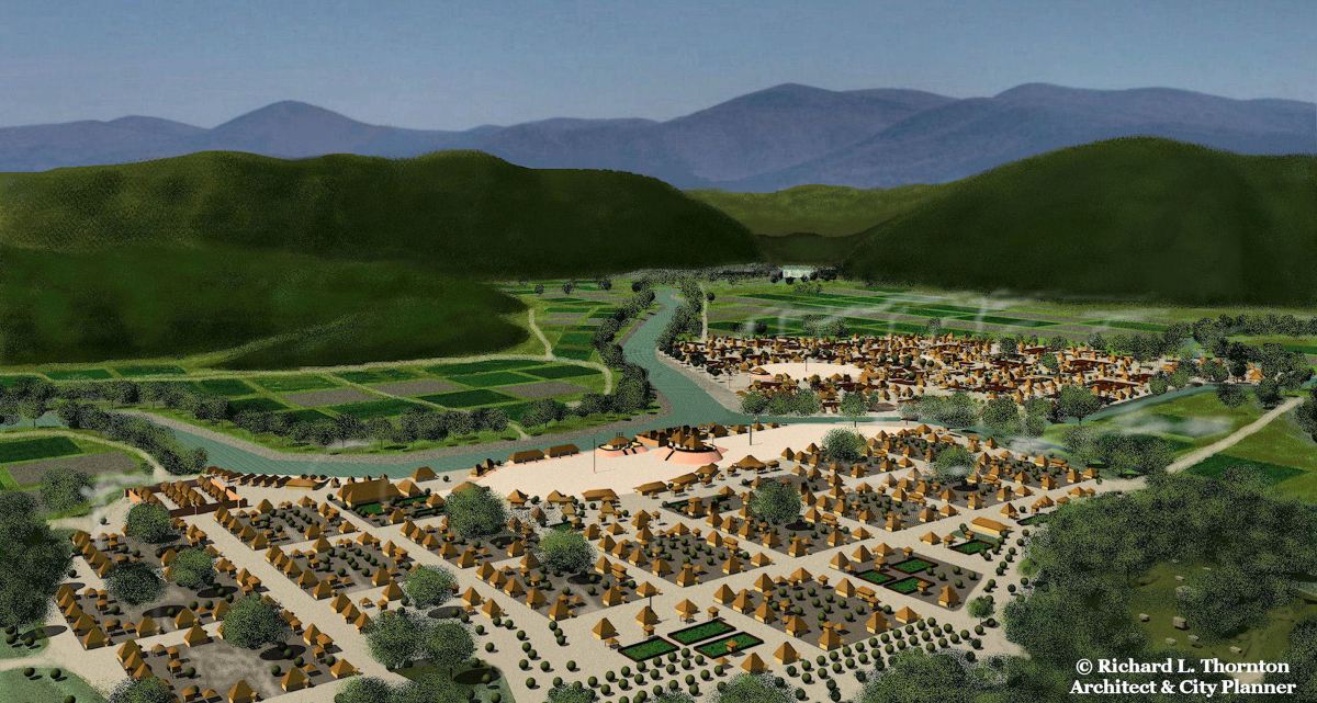
Image Above: Birdseye view of Kusa in the summer of 1540
Chiaha was the name of a Native American province in the Southern Appalachians. Ichiaha (Ychiaja in Spanish) was the name of its capital. Both place names are pure Itza Maya etymology and grammar. In Itza and Itsate Creek, placing an “I or E” in front or at the end of a proper noun made it the principal place or capital. Chiaha means “Salvia River.” The name of the Mexican State of Chiapas means “Salvia – Place of.”
The De Soto Chronicles refer to large fields of salvia growing along the rivers as they approached the capital. They also mention indigenous honey bees, which the Itza Mayas of Chiapas domesticated!
That we even know that Chiaha existed in the Southern Appalachians as a province during the 1500s is due to the chronicles of the De Soto (1539-1544) and Juan Pardo Expeditions (1567-1569). By the time that the Province of Georgia was founded in 1733, Chiaha was a large town in what would become the southwestern section of the State of Georgia and a member of the Creek Confederacy. Thus, any information provided on the original geographical location of the province is dependent on what these 16th century Spaniards wrote.
A map was produced of what is now the Southeastern United States to accompany the 1544 report to the Spanish king on the De Soto Expedition. Other important sources of information on the province of Chiaha’s location may be found on 17th century French maps.
The towns of Ichiaha, Cusate (Coste) and Tasqui. are the only ones definitely visited by both the De Soto and Pardo Expeditions. Some academicians think that Cofitachequi may have gone by a different name, twenty years after the De Soto Expedition . . . and thus been visited also by Pardo. Chiaha was at the bottom of a deep river gorge in high mountains. Cusate and Tasqui were on islands in the Tennessee River. Cusate was west of Ichiaha and near the mouth of a deep gorge that connected the two towns.

Etymology and pronunciation guide
Apparently, the late 20th century, Southeastern university anthropology professors, who “determined” the routes of Spanish explorers through the present-day Georgia, Carolinas, Tennessee and Alabama, were ignorant of the Spanish, Muskogean and Itza Maya languages. They mispronounced and/or misinterpreted most of the indigenous words, recorded in the De Soto and Pardo Chronicles. Thus, when PBS’s “Secrets of the Dead” filmed a documentary on the Pardo Exhibition, entitled, “The Secrets of Spanish Florida (2017), the script writers assumed that PhD’s in Anthropology knew the correct pronunciation of these words, so then passed them on to the nation. The professors also told the scriptwriters that “De Soto and Pardo came through Asheville” fable, even though it had been thoroughly disproven 17 years earlier. It’s a jungle out there in Native American history!
The 15 languages of the Iberian Peninsula do not utilize a letter W, unless writing a foreign word. During the Renaissance, there were several combination of Roman letters, which were used by licensiados (notaries) in these expeditions to portray the English/Germanic and Native America “W” sound.
Like their relatives in southern Mexico, the Creeks had several S sounds. The most common ones in English phonetics were (sh), (jzh) (ts) and (s). The majority were an “sh” sound. Whereas English uses an “sh” and French uses a “ç”, Renaissance era Spanish licensiados and authors in the Iberian Peninsula sometimes use an “x” . . . sometimes a “ç” . . . and sometimes an “s” to portray an “sh” sound. Thus, Suale or Xuale should pronounced Jzhū : ä : lē.
1 – Cofitachequi was a powerful province in the Coastal Plain of present-day South Carolina that was at war with the Okvte Creeks on the Oconee River in present-day Georgia. The De Soto Chronicles state that the Spaniards traveled toward the rising sun from Ocute ( Okvte) to Cofitachequi, which in March 1540, would have been a South-Southeasterly direction. The actual Muskogee-Creek word is Kofitvshiki and means “Descendants of Mixed Race-People.” Interestingly enough, we now know that the tribal name Maskoke (Muskogee) originated in the 18th century as a hybrid of the Sephardic Jewish word, masko, which means “mixed race” and the Muskogee-Creek suffix for “people or tribe” . . . “ki”
To this day, North Carolina academicians argue that Cofitachequi was Cherokee, while South Carolina academicians contend that it was Catawba. Obviously, neither batch of scholars know the meaning of the word.
Cofitachequi was described as being two days march from the Atlantic Ocean (+/- 30 miles or 48 km). South Carolina members of the De Soto Expedition Academic Consortium pressured the group to adopt a former Native American town on the Mulberry Plantation, near Camden, SC, as the location of Cofitachequi, even though it was 100.83 mi (162.26 km) from the Atlantic Ocean.
2 – Xuale or Suale was a town at the edge of the Blue Ridge Mountain Escarpment. It is both a Shawnee and Creek word, which means “vulture or buzzard.” The word is pronounced, Jzhwä : lē.
The Xuale were a culturally advanced Shawnee-speaking tribe in northern West Virginia, who were mound builders. Their mortuary cult religion seems very similar to that of the Hopewell Culture, so they may well have been descendants of the Hopewell Culture.
None of the authors of the De Soto Chronicles (1995) were aware that the town of Xuale was merely a colony of a very large tribe in West Virginia, which was arch-enemies of the Cherokee. Most of these professors called Xuale a Cherokee village.
3 – Guaxuli/Guasile/Guasale is pronounced Wä : shäw : lĭ. It is Creek word, not the name of “the Ancient capital of the Cherokee Nation.” The Anglicized version of the word would be Washawle, meaning “Washaw People.” The Washaw lived on Wassaw Island, GA . . . along the Savannah River up to the Little Tennessee River . . . plus, in Lancaster County, SC and Union County, NC, near the Catawba River. The most likely place for the Guaxule, visited by De Soto, is at the headwaters of the Little Tennessee River or the headwaters of the French Broad River, since the village was described as being at the foot of the mountains.
4 – Conasaga was a village on the river between Guaxule and Chiaha and associated with the Conas People, mentioned in the Pardo Chronicles. It is pronounced Kō : nä : shäu : gē. It was a Muskogee-Creek-speaking village. Conas tribal villages, which spoke Itsate Creek were called Conasate. They are also mentioned in the Spanish chronicles.
Charles Hudson changed the spelling to Conasagua in his books, thinking that the change would make the word look more “Cherokee.” Actually, the “gua” suffix in Middle Arawak, not Cherokee
5 – Coste is the Spanish spelling of a large town on an island, downstream from Chiaha. It was an Upper Creek town, which was occupied until at least 1715, because it is displayed on the John and Richard Beresford 1715 Map.
The actual word in Itsate Creek is Kawsete and are Itza Maya words, meaning, “Descendants of Eagle – People.” The English spelling is Kusate or Cusate and is pronounced, Kü : shä : tē. The word Cusate or Coushatta came to mean all Upper Creeks.
6 – Tasqui was a large town on Hiwassee Island, Tennessee, which was about 90 miles (145 km) downstream from Bussell Island, where the town of Coste (Kusate) was located. The Creek word is tvske and means “piliated woodpecker.” The main concentration of Tvske villages was originally in the Nantahala Mountains of North Carolina in what is now Cherokee, Clay and Macon Counties. They were alternatively called Tvskete (Itsate Creek) or Tvskegi (Muskogee Creek).
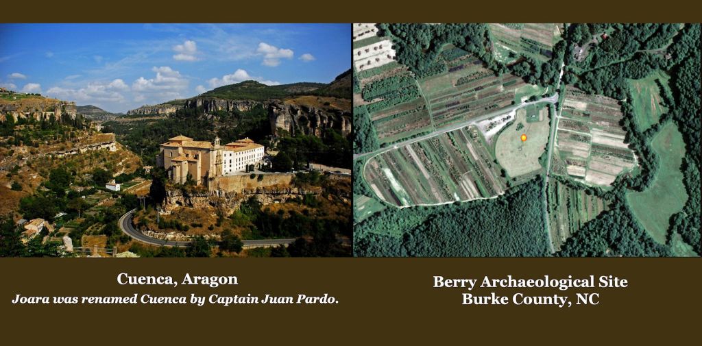
7- Joara was a large, politically powerful town in a gorge at the edge of the Blue Ridge Mountains Escarpment with many temples, plazas and streets. It was adjacent to a river and downstream from the convergence of four fast running rivers. It was subscribed by Juan Pardo as looking like his hometown of Cuenca, Spain.
As a Spanish spelling of an indigenous word, it is pronounced, “hō : ä : [r]ä . . . not Joe – are – uh as everyone in the Carolinas is pronouncing it. Joara is not at all the same word as Xuale, as speculated by Charles Hudson . . . and now parroted in the 21st century by many academicians. It is also okay to use the Anglicized form of Joara, Wara, which is actually closer to the indigenous word. Wara is probably a word of South American origin, an English R sound does not occur in the Creek, Maya or Cherokee languages.
9 – Ajo was a village in the Coastal Plain of South Carolina, which specialized in growing sweet potatoes [Pardo Chronicles]. It is pronounced Ä : hō and means “sweet potato” in Creek and Southern Arawak.
10 – Chalique, Chilique or Chiloque – This was a tribe of hunters and gatherers in the South Carolina Piedmont. Chiliki means “barbarians” in Totonac, Itza Maya and Creek.
11 – Chalohuma was a town in the mountains of North Carolina, mentioned by the Pardo Chronicles. It is an Alibaama word meaning “red fox.”
12 – Satipo was a town on the Tellico River in the North Carolina and Tennessee Mountains. It is also the name of a city and province in Peru. The word is Panoan from Peru and means “Colonists-Place of.” Santee (as in the river) had the same meaning as “sati.”
13 – Tali was a town on the Little Tennessee River, mentioned in the De Soto Chronicles. It’s name is probably their interpretation of the Creek pronunciation of Itza Maya (Itsate) word Tula-e, which means “Principal Town.” Alternatively, tauli is the Itza Maya, Creek, Chickasaw and Choctaw word for a stone.
14 – Coça was the Spanish name for a great town in northwestern Georgia in which the De Soto Expedition stayed several weeks. Coça was the way that the Spanish chroniclers portrayed the sounds of the indigenous sounds, Kăw : shē. English-speakers typically write the word as Coosa or Kusa.
The word has two possible etymologies. They may have been used simultaneously. Kawshe means “Eagle – descendants of” in Itza Maya and Itzate Creek. Kaushe means “strong or elite” in the Panoan languages of Peru. There was a Panoan tribe named the Kaushebo, who became know as Cusabo in South Carolina.
15 – Talamachuse was a new town near Coça, mentioned by the De Soto Chronicles. It is the Spanish interpretation of Tula-machuse, which means “town-new” in Itza Maya and Itsate Creek.
16 – TocaE was an ethnic name, used in the Pardo Chronicles, for a tribe living in the mountains north of Joara. There are numerous place names in NE Georgia and NW South Carolina, which are derived from this word, but it is actually the name of the capital of the Tokah or Tokahle People. This indisputable ethnic fact totally negates the Berry Site as the location of Joara. Tokahle now means “freckled or spotted skin” today in Muskogee Creek. Descendants of the Tokahle included the Creek town of Tuckabatchee and the Tokasee Creeks, who eventually relocated to Florida and joined the Seminole Confederacy. The Tokah definitely were NOT Cherokees as now claimed in several Wikipedia articles.
17 – Katapa was the Spanish spelling of the name of two towns, mentioned by the Pardo Chronicles. The word is never used as tribe. Kataw’pa is Itza Maya and means “Crown – place of.” Apparently, Southeastern anthropologists look at historic maps.
Look at the pre-Revolutionary maps of Georgia . . . for example, John Mitchell’s 1755 map of North America. The area between present-day Atlanta and Gainesville is labeled, “Kataapa.” That’s the real Katapa Tribe. They were Itsate Creeks. The Catawbas of the Carolinas were evidently a confederation of primarily Siouian-speaking tribes, headed by two Katawpa Creek towns in South Carolina.
18 – Heneha was described in the Pardo Chronicles as a judge, who traveled from village to village to hear court cases. They were siblings of the Great Sun (High King). Today, it is the official title of the Second Chief of the Muskogee-Creek Nation. The original words were Hene ahaw (Itza Maya) and mean “Sun Lords.” Like in the Pardo Chronicles, they were siblings of the high king and functioned as traveling judges and representatives of the High King.
19 – Orata or Olata (French) – This is term used in the Pardo Chronicles for a village chief. The word is Panoan from Peru and means the same. When I found the Panoan origin of this word in 2012, I realized that there had been a substantial presence of Peruvian immigrants in the Southeast, which had been missed by 20th century anthropologists. The word is used today in Muskogee-Creek to denote a neighborhood leader, foreman or chief of a hamlet.
20 – Uriwa is the word for “king” in Panoan and several Pre-Columbian languages in South Carolina and Georgia’s Coastal Plain.
21 – Talimeco is the title of the leader of many towns visited by De Soto. It is the Spanish interpretation of Tulai-meco, which means Town – King (chief). Meco or mikko is derived from the Itza word, mako, and literally means “great.”
22 – Olameco or Ulameco was a title for a king of a province. It roughly means “leader of kings” and is derived from the Itza Maya title, Ulamako.
23 – Cacique or casica is used in many passages of the De Soto and Pardo Chronicles to denote a village chief. A cacique (Latin American Spanish: [kaˈsike]; feminine form: cacica) translates to “king” of an indigenous group, derived from the Taíno word kasike for the pre-Columbian tribal chiefs in the Bahamas, the Greater Antilles, and the northern Lesser Antilles.
Although there were definitely Tainos living on Jekyll Island, GA and probably in some villages, elsewhere in the Lower Southeast, the term was probably being used generically. In the colonial era, Spaniards extended the word as a title for the leaders of practically all indigenous groups that they encountered in the Western Hemisphere.
Video on the Berry Site
In this short video, you will see three archaeologists with PhD’s from the University of North Carolina-Chapel Hill repeatedly mispronouncing Joara. They either say Joe-ara or Jora. Jora was the English name of a briefly occupied Cherokee village in eastern Tennessee. Neither “Jo” or “ra” are sounds in the Cherokee language. North Carolina academicians, who obviously didn’t know the correct pronunciation of Joara equated the two names to “prove” that Joara was a Cherokee village.
One speaker mentioned the gold rush in North Carolina. He then described a theoretical triangle of Pardo Forts, which form a triangle with Charlotte at its center. Only trouble is that one of those points is a location for Chiaha, which was disproven two decades ago and the other point is theoretical. Apparently, he didn’t know his own North Carolina geology. Burke County, where this site is located, is the primary gold-mining county in North Carolina today. He may have found a 16th century or early 17th century gold mining venture.
A three feet tall mound does not denote “a major center of Mississippian Culture” as the film claims. However, there is no doubt that a small village at the Berry Site contains Creek-style houses . . . typical of the suburbs of Chichen Itza before 1000 AD, the first phase of Etowah Mounds occupation and later on, in the Tennessee Valley. They have apparently identified a burned European fort and some 16th century European artifacts.
That being said, the location bears no resemblance to the description of Joara in the Pardo Chronicles. The archaeologists make the viewer think that every they are saying are absolute facts. It may well be one of the other forts, constructed by Juan Pardo, but may also be something else. Native American scholars call that “smoke and mirrors” archaeology.
